

Surf Forecasts:

La Derecha del Cartel surf forecast from 3 Aug 2026:
- Best quality surf: Thursday 6 Aug, 1PM (local time) - 5.5ft (1.7m), 6s period, NE swell with glassy winds.
- Most powerful swell: Thursday 6 Aug, 1PM (local time) - 5.5ft (1.7m), 6s period, NE swell with 216 kJ wave energy.
- Next surfable swell (1★+): Tuesday 4 Aug, 1AM (local time) - 4.5ft (1.3m), 6s period with NE swell.
Best Forecast Surf Conditions for La Derecha del Cartel this week:
The surf forecast for La Derecha del Cartel over the next 16 days: The first swell (rated 1 star or higher) is forecast to arrive on Tuesday (Aug 04) at 1AM. The primary swell is predicted to be 1.3m and 6s period. The wind is predicted to be cross-offshore as the swell arrives.
The most powerful waves expected at La Derecha del Cartel in the next 16 days are 1.7m 6s and forecast to arrive on Thursday (Aug 06) at 1PM. Winds are predicted to be glassy at the time the swell arrives. The largest open ocean swell (not directed at the beach) is 1.6m 6s period and expected on Monday (Aug 03) at 4PM.
| Wave Type | Time (WEST) & Date | Wave Height & Period |
|---|---|---|
| Next good surf (1 star+) | 1AM (Tue 4th Aug) | 4.5ft (1.3m) 6s |
| Best Surf | 1PM (Thu 6th Aug) | 5.5ft (1.7m) 6s |
| Most Powerful | 1PM (Thu 6th Aug) | 5.5ft (1.7m) 6s |
Table - best surf conditions forecast for La Derecha del Cartel over the next 16 days.
The Lowdown
Alright, Rusty here. Let's talk about what's coming up at La Derecha del Cartel.
We're looking at a classic case of patience being a virtue. The start of the period is a total write-off. Monday, the 3rd of August, has a tiny 1ft swell with a weak 21 units of energy. It’s just not happening. That pretty much sets the tone for the next several days. We're staring down a gap of about five days of flat to near-flat conditions, with nothing worth paddling out for. The first real sign of life doesn't show up until Thursday afternoon, the 6th of August.
That Thursday afternoon is when things finally kick off. The swell jumps to 5ft from the NE, with a short period of 6 seconds. The energy reads at a moderate 202 units, and with a clean offshore wind from the SE, it’s going to be a fun, punchy session. That’s the first standout, but it's a bite-sized window.
The real gem, and the one I'm circling on the calendar, is the stretch from Monday the 17th of August through Tuesday the 18th. This is the best the forecast has to offer. On Monday morning, we’ve got a 4ft NE swell, a period stretching to 8 seconds, and a solid 219 units of energy. The wind is glassy, dead calm. That afternoon sees 5ft swell with 250 units of energy and glassy conditions. It’s going to be clean, lined up, and absolutely perfect for that reef. Then Tuesday keeps the momentum with 4ft NE swell, the period pushing out to 9 seconds, and energy hitting 280 units under glassy conditions. That’s the pick of the fortnight. Keep in mind this is a long-range call, so it’s a promising prospect, not a guarantee, but it looks fantastic.
Now, before that, we get another window. Tuesday afternoon, the 11th of August, sees a 6ft NE swell, but it's a short 6-second period. The energy is a strong 299 units, and the wind is a clean cross-offshore from the S. That’s a solid wave, but that size and short period can make it a bit of a handful and maybe a bit messy. Still, it’s worth a look. The following days, the 12th and 13th, have consistent 4ft to 5ft NE swell with moderate energy, but the wind is variable, and the quality is just "ordinary" rather than excellent.
The water temp is sitting at 73°F, which is basically bang on average for this time of year, so no surprises there.
The entire second week is a bit of a mixed bag. After that Tuesday the 11th highlight, the swell stays around 4ft to 5ft, but the wind gets messy, mostly onshore from the NW, which will make it a bumpy, blown-out affair. Avoid the 14th, 15th, and 16th of August. The wind is just wrong for this spot.
For the true standout, you’re looking at the 17th and 18th of August. Clear skies, glassy conditions, and a solid, moderate swell with good energy. That’s the one.
Rusty.
Short Range ForecastMostly dry. Warm (max 32°C on Tue morning, min 27°C on Wed night). Wind will be generally light. | Days 4-6 Weather SummaryMostly dry. Warm (max 29°C on Thu morning, min 24°C on Thu night). Wind will be generally light. | ||||||||||||||||||||
Monday 3 | Tuesday 4 | Wednesday 5 | Thursday 6 | Friday 7 | Saturday 8 | Sunday 9 | |||||||||||||||
AM | PM | Night | AM | PM | Night | AM | PM | Night | AM | PM | Night | AM | PM | Night | AM | PM | Night | AM | PM | Night | |
Swell Height Map |  |  | 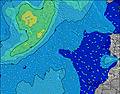 | 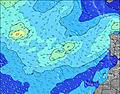 | 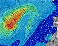 | 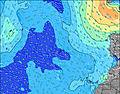 | 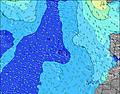 | ||||||||||||||
Wave Height (m) Direction Period (s) | NE 5 | NW 9 | NE 6 | NW 9 | NW 9 | NE 6 | WNW 9 | NW 10 | NW 10 | NW 10 | NE 6 | NE 7 | NE 7 | WNW 9 | NE 8 | WNW 8 | NW 5 | NW 4 | NW 4 | NW 4 | NE 6 |
Wave Graph | |||||||||||||||||||||
65 | 21 | 100 | 20 | 19 | 131 | 17 | 27 | 24 | 24 | 181 | 140 | 121 | 8 | 142 | 7 | 7 | 5 | 3 | 7 | 136 | |
Wind (km/h) | |||||||||||||||||||||
Wind State on-shore cross-onshore cross-shore cross-offshore off-shore glassy | glassy | glassy | cross-off | cross-off | cross | cross | cross-off | glassy | glassy | off | off | off | on | glassy | on | on | glassy | glassy | glassy | glassy | glassy |
High Tide | 4:48PM1.79m | 5:15AM1.60m | 5:28PM1.69m | 6:01AM1.53m | 6:19PM1.56m | 6:59AM1.45m | 7:27PM1.44m | 8:17AM1.41m | 8:58PM1.38m | 9:48AM1.45m | 10:32PM1.42m | 11:06AM1.58m | 11:45PM1.54m | ||||||||
Low Tide | 10:31AM0.28m | 11:03PM0.24m | 11:11AM0.36m | 11:44PM0.32m | 12:00PM0.45m | 00:36AM0.42m | 1:05PM0.54m | 1:46AM0.52m | 2:35PM0.58m | 3:17AM0.55m | 4:14PM0.51m | 4:44AM0.48m | 5:32PM0.36m | ||||||||
7:30 | — | — | 7:30 | — | — | 7:31 | — | — | 7:31 | — | — | 7:31 | — | — | 7:31 | — | — | 7:33 | — | — | |
— | 8:54 | — | — | 8:54 | — | — | 8:53 | — | — | 8:52 | — | — | 8:52 | — | — | 8:52 | — | — | 8:51 | — | |
mm | — | — | — | — | — | — | — | — | — | — | — | — | — | — | — | — | — | — | — | — | — |
Temp °C | 31 | 30 | 30 | 32 | 32 | 31 | 30 | 29 | 28 | 29 | 27 | 25 | 26 | 26 | 26 | 27 | 27 | 26 | 26 | 26 | 25 |
Feels °C | 32 | 32 | 28 | 32 | 31 | 32 | 30 | 31 | 28 | 30 | 28 | 26 | 27 | 28 | 27 | 27 | 29 | 27 | 28 | 28 | 27 |
Swell 1 Height (m) Direction Period (s) | ENE 5 | ENE 6 | ENE 6 | SSW 12 | SSW 14 | ENE 5 | SSW 13 | SSW 13 | NW 10 | ENE 6 | ENE 6 | ENE 8 | ENE 8 | ENE 7 | ENE 8 | ENE 7 | ENE 6 | ENE 6 | ENE 7 | ENE 5 | ENE 6 |
28 | 60 | 34 | 47 | 41 | 46 | 34 | 57 | 24 | 66 | 85 | 58 | 34 | 43 | 35 | 30 | 37 | 22 | 25 | 21 | 29 | |
Swell 2 Height (m) Direction Period (s) | SSW 12 | S 12 | SSW 12 | NW 9 | SSW 12 | SSW 14 | WNW 9 | NW 10 | SSW 12 | NW 10 | WNW 9 | WNW 9 | WNW 9 | NW 5 | NW 5 | NW 5 | NW 5 | NW 4 | NW 4 | NW 4 | NW 4 |
50 | 77 | 49 | 20 | 27 | 40 | 17 | 27 | 29 | 24 | 17 | 17 | 16 | 4 | 7 | 3 | 7 | 5 | 3 | 7 | 3 | |
Swell 3 Height (m) Direction Period (s) | WNW 9 | NW 9 | NW 9 | NW 4 | NW 9 | NW 8 | SSW 11 | NNW 5 | NW 5 | SSW 12 | NW 5 | SSW 11 | NW 5 | WNW 9 | WNW 9 | WNW 8 | SSW 12 | SSW 12 | S 12 | SSW 12 | SSW 11 |
16 | 21 | 22 | 1 | 19 | 10 | 12 | 2 | 4 | 29 | 4 | 25 | 4 | 8 | 8 | 7 | 30 | 29 | 11 | 27 | 12 | |
Wind waves Height (m) Direction Period (s) | NE 5 | NE 6 | NE 6 | ENE 6 | ENE 6 | NE 6 | ENE 6 | ENE 6 | ENE 6 | NE 6 | NE 6 | NE 7 | NE 7 | NE 7 | NE 8 | — | NE 6 | NE 6 | NE 5 | NE 5 | NE 6 |
65 | 171 | 100 | 93 | 74 | 131 | 154 | 127 | 60 | 175 | 181 | 140 | 121 | 126 | 142 | — | 129 | 56 | 35 | 74 | 136 | |
Nearest Offshore or Glassy | |||||||||||||||||||||
Distance (km) | 0 | 1 | 0 | 1 | 1 | 1 | 1 | 1 | 1 | 1 | 0 | 0 | 79 | 79 | 515 | 515 | 19 | 529 | 79 | 79 | 0 |
Best forecast wave conditions in Tenerife | |||||||||||||||||||||
Best forecast wave conditions in Spain (Africa) | |||||||||||||||||||||
Header Global | |||||||||||||||||||||
- Map Icons:
 Break
Break Live Wave Height (m)
 Live Wind Speed (km/h)
 Surf Rating (10 Max)
 Ocean Swells (m)
- Wind Speed (km/h)
Latest Updates


FREE! Surf-Forecast.com widget for your website
The surf report / weather widget below is available to embed on third party websites free of charge and provides a summary of our La Derecha del Cartel surf forecast. Simply grab the html code snippet that we provide and paste it into your own site. You can choose your preferred language and metric/imperial units for the surf forecast feed to suit users of your site. Click here to get the code.
Information about the La Derecha del Cartel Surf forecast
The above surf forecast table for La Derecha del Cartel provides essential information for determining whether the surfing conditions will be good over the next 16 days. A general guide to surfing at La Derecha del Cartel can be found by selecting the local surf guide option on the grey menu. Our La Derecha del Cartel surf forecast is unique since it includes wave energy (power) that defines the real feel of the surf rather than just the height or the period. If you surf the same spot (La Derecha del Cartel) regularly then make a mental note of the wave energy from the surf forecast table each time you go. Very soon you may start to choose your surf days based on the wave energy alone combined with our forecast of favourable offshore wind conditions. Our star ratings will help here and of course you will also find the usual wave height and period predictions on our surf forecasts as well as a full break down of the swell components under our advanced users option (to reveal that, click the little Einstein character under the tide times).
Further information to help with frequently asked questions about our surf forecast for La Derecha del Cartel may be found under the help tab on the top menu and also by moving your mouse over the question marks on the surf forecast table itself. Please always bear in mind that the forecast is for near-shore open water and local factors at each surf break influence the actual breaking wave height, such as the beach / reef profile, water depths offshore and shelter.
La Derecha del Cartel is 7 km (4 miles) from the city of Adeje. If you plan a holiday in Tenerife, look for hotels and other accommodation in Adeje. Adeje has rooms for a wide range of budgets as well as car hire and transport links.
 Nearest