

Surf Forecasts:

Mosca Point surf forecast from 8 Jul 2026:
- Best quality surf: Sunday 12 Jul, 7AM (local time) - 3.5ft (1.0m), 11s period, NNW swell with offshore winds.
- Most powerful swell: Sunday 12 Jul, 7AM (local time) - 3.5ft (1.0m), 11s period, NNW swell with 226 kJ wave energy.
- Next surfable swell (1★+): Sunday 12 Jul, 7AM (local time) - 3.5ft (1.0m), 11s period with NNW swell.
Best Forecast Surf Conditions for Mosca Point this week:
The surf forecast for Mosca Point over the next 16 days: The first swell (rated 1 star or higher) is forecast to arrive on Sunday (Jul 12) at 7AM. The primary swell is predicted to be 1.0m and 11s period with a secondary swell of 0.8m and 11s. The wind is predicted to be offshore as the swell arrives.
The most powerful waves expected at Mosca Point in the next 16 days are 1.0m 11s and forecast to arrive on Sunday (Jul 12) at 7AM. Winds are predicted to be offshore at the time the swell arrives. The largest open ocean swell (not directed at the beach) is 1.0m 5s period and expected on Thursday (Jul 09) at 4AM.
| Wave Type | Time (WEST) & Date | Wave Height & Period |
|---|---|---|
| Next good surf (1 star+) | 7AM (Sun 12th Jul) | 3.5ft (1.0m) 11s |
| Best Surf | 7AM (Sun 12th Jul) | 3.5ft (1.0m) 11s |
| Most Powerful | 7AM (Sun 12th Jul) | 3.5ft (1.0m) 11s |
Table - best surf conditions forecast for Mosca Point over the next 16 days.
G’day, Rusty here. We’ve got a long view ahead for Mosca Point, and I gotta be straight with you – it’s a slow burner. The first week or so is pretty flat and frustrating, but there’s a pulse building in the second week that could make things interesting for the crew willing to wait.
Right now, starting Wednesday the 8th, we’re lookin’ at tiny dribble. Swell heights barely a whisper at 0.3 ft from the north, with the combined energy sittin’ at a measly 1. That’s weak stuff. Winds are offshore, sure – a nice north breeze around 12 mph – but there’s just no water moving. This poor excuse for surf carries right through the 9th, 10th, and into the 11th. Saturday the 11th offers a tiny bump in period to 13 seconds on the afternoon, but swell height is still only 0.3 ft and the combined energy is just 6 – not enough to get excited about. You’re lookin’ at a solid 5-day gap of flatness before anything worthwhile shows.
Sunday the 12th morning is where we finally get a pulse. Swell jumps to 3 ft from the NNW, period 10 seconds, and combined energy hits 149 – that’s moderate energy, finally some push. Wind is offshore from the NNE at 12 mph, so it’s clean. The score might only be a 1, but this is the first surfable option in the whole run. Still, it’s very ordinary at best.
Monday 13th and Tuesday 14th drop back a notch – swell down to 2 ft and 2 ft, energy falling to 75 and 45 – nothing worth paddlin’ for. Wednesday 15th morning brings a fresh NNE breeze at 19 mph and a 2 ft swell – still poor.
Now here’s where it starts to get interesting. Friday the 17th – that’s over a week away – we see a big jump. Morning swell hits 5 ft from the NNE, period only 6 seconds though, and combined energy is 211 – moderate. Wind is offshore from the north at 19 mph. With that short period (under 8 seconds), the waves will be a bit weak and probably closey, but there’s size. By Saturday the 18th, it’s building: 6 ft to 6 ft from the NNE, energy up to 363–387, still with a fresh north wind. The swell’s gettin’ solid, but we’re still in “marginal” territory.
The real standout comes on Sunday the 21st through to Wednesday the 23rd of July. Sunday 21st has swell holding at 6 ft from the NNE, period 8 seconds, combined energy soaring to 492–528 – strong energy, that’s proper power. Wind is offshore, moderate breeze around 16 mph. The morning of Tuesday the 22nd is your top pick: 6 ft NNE swell, 8-second period, 519 combined energy, clean conditions with a north wind at 12 mph. It’s the first time we get a score of 2 in the whole run – expect good surf. This is the one to aim for. The optimum swell direction is N, and we’re getting NNE – close enough, and with that offshore flow, it should be clean and lined up.
Wednesday 23rd morning pushes up to 7 ft from the NNE, period 9 seconds, with energy at a big 751 – now we’re into strong to very strong wave energy. That’s a big, powerful swell, but it’s getting into expert territory (over 7 ft), so only the experienced crew should be out. Wind is a fresh 19 mph north breeze, offshore, so it’ll be clean and heavy.
Mosca Point is a beach and reef setup, sheltered from the north. It’s “fairly consistent” but for this stretch, the first week is a total write-off. Water temp is 71°F, which is about average for the time of year – anomaly is just 0.4°F, so no surprises there. Crowds can show up “sometimes,” so when that Sunday 21st run hits, expect a few others who’ve been waiting.
If you can hold out, the 21st through 23rd is where it’s at. Early week is a total flat spell – don’t bother. The big pulse late in the run is your ticket.
Rusty.
Short Range ForecastMostly dry. Warm (max 29°C on Wed afternoon, min 21°C on Thu night). Wind will be generally light. | Days 4-6 Weather SummaryMostly dry. Warm (max 24°C on Sat afternoon, min 19°C on Mon night). Wind will be generally light. | ||||||||||||||||||||
Wednesday 8 | Thursday 9 | Friday 10 | Saturday 11 | Sunday 12 | Monday 13 | Tuesday 14 | |||||||||||||||
AM | PM | Night | AM | PM | Night | AM | PM | Night | AM | PM | Night | AM | PM | Night | AM | PM | Night | AM | PM | Night | |
Swell Height Map |  |  | 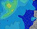 | 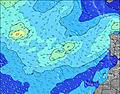 | 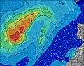 | 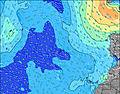 | 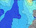 | ||||||||||||||
Wave Height (m) Direction Period (s) | N 8 | NNE 7 | NW 10 | NW 9 | NW 9 | NW 9 | NW 9 | NW 9 | NW 9 | NW 9 | NW 13 | NW 12 | NNW 10 | NNW 9 | NNW 8 | NNW 9 | NNW 9 | NNW 8 | NNW 8 | NNW 8 | N 9 |
Wave Graph | |||||||||||||||||||||
1 | 5 | 4 | 3 | 3 | 3 | 3 | 3 | 3 | 3 | 6 | 36 | 149 | 146 | 80 | 75 | 67 | 38 | 36 | 37 | 42 | |
Wind (km/h) | |||||||||||||||||||||
Wind State on-shore cross-onshore cross-shore cross-offshore off-shore glassy | off | off | off | off | off | off | off | off | off | off | cross-off | off | off | cross-off | off | off | cross-off | off | off | cross-off | off |
High Tide | 8:08PM1.66m | 8:59AM1.59m | 9:24PM1.64m | 10:11AM1.65m | 10:41PM1.68m | 11:19AM1.77m | 11:50PM1.77m | 12:18PM1.91m | 00:50AM1.87m | 1:12PM2.06m | 1:43AM1.95m | 2:01PM2.18m | 2:32AM1.99m | ||||||||
Low Tide | 1:47PM0.60m | 2:32AM0.48m | 3:05PM0.58m | 3:45AM0.46m | 4:24PM0.50m | 4:56AM0.41m | 5:35PM0.36m | 5:59AM0.32m | 6:36PM0.21m | 6:54AM0.22m | 7:31PM0.07m | 7:44AM0.15m | 8:21PM-0.02m | ||||||||
7:11 | — | — | 7:11 | — | — | 7:11 | — | — | 7:13 | — | — | 7:13 | — | — | 7:13 | — | — | 7:13 | — | — | |
— | — | 9:00 | — | — | 9:00 | — | — | 9:00 | — | — | 9:00 | — | — | 9:00 | — | — | 9:00 | — | — | 9:00 | |
mm | — | — | — | — | — | — | — | — | — | — | — | — | — | — | — | — | — | — | — | — | — |
Temp °C | 28 | 29 | 27 | 26 | 25 | 23 | 24 | 24 | 22 | 23 | 24 | 23 | 23 | 23 | 22 | 23 | 23 | 21 | 23 | 23 | 21 |
Feels °C | 27 | 29 | 26 | 25 | 23 | 21 | 23 | 23 | 21 | 23 | 25 | 23 | 23 | 23 | 21 | 22 | 21 | 20 | 21 | 21 | 19 |
Swell 1 Height (m) Direction Period (s) | SW 16 | NNE 7 | SW 16 | SW 16 | SSW 16 | SSW 16 | SSW 15 | SSW 15 | SSW 15 | SSW 19 | SSW 14 | NW 12 | NNW 10 | NNW 9 | NNW 8 | NNW 9 | NNW 9 | NNW 8 | NNW 8 | NNW 8 | N 9 |
11 | 5 | 10 | 10 | 25 | 24 | 23 | 21 | 21 | 37 | 19 | 36 | 149 | 146 | 80 | 75 | 67 | 38 | 36 | 37 | 42 | |
Swell 2 Height (m) Direction Period (s) | N 8 | SW 16 | NW 10 | NW 9 | NW 9 | NW 9 | NW 9 | NW 9 | NW 9 | SSW 14 | SSW 19 | SSW 14 | SSW 18 | SSW 13 | SSW 16 | SSW 16 | SSW 15 | SSW 15 | SSW 14 | SSW 13 | NNW 8 |
1 | 10 | 4 | 3 | 3 | 3 | 3 | 3 | 3 | 20 | 37 | 18 | 61 | 17 | 51 | 25 | 43 | 21 | 20 | 18 | 7 | |
Swell 3 Height (m) Direction Period (s) | — | NE 6 | W 7 | — | — | — | S 12 | S 21 | SW 21 | NW 9 | NW 13 | SSW 18 | SSW 13 | SSW 17 | SSW 13 | SSW 12 | SSW 12 | SSW 12 | SSW 12 | N 10 | SSW 13 |
— | 2 | 1 | — | — | — | 3 | 9 | 18 | 3 | 6 | 31 | 18 | 29 | 16 | 15 | 14 | 13 | 14 | 8 | 17 | |
Wind waves Height (m) Direction Period (s) | N 4 | N 4 | N 5 | N 5 | N 5 | NNE 6 | NNE 5 | NNE 5 | NNE 5 | N 5 | N 5 | N 4 | N 4 | N 6 | NNE 4 | NNE 4 | NNE 4 | NNE 4 | NNE 4 | NNE 4 | NNE 5 |
26 | 20 | 34 | 55 | 59 | 65 | 60 | 50 | 36 | 19 | 12 | 15 | 10 | 1 | 5 | 9 | 11 | 16 | 11 | 16 | 36 | |
Nearest Offshore or Glassy | |||||||||||||||||||||
Distance (km) | 132 | 1465 | 132 | 132 | 123 | 123 | 27 | 17 | 17 | 17 | 17 | 20 | 0 | 20 | 20 | 20 | 20 | 27 | 20 | 27 | 123 |
Best forecast wave conditions in Gran Canaria | |||||||||||||||||||||
Best forecast wave conditions in Spain (Africa) | |||||||||||||||||||||
Header Global | |||||||||||||||||||||
- Map Icons:
 Break
Break Live Wave Height (m)
 Live Wind Speed (km/h)
 Surf Rating (10 Max)
 Ocean Swells (m)
- Wind Speed (km/h)


FREE! Surf-Forecast.com widget for your website
The surf report / weather widget below is available to embed on third party websites free of charge and provides a summary of our Mosca Point surf forecast. Simply grab the html code snippet that we provide and paste it into your own site. You can choose your preferred language and metric/imperial units for the surf forecast feed to suit users of your site. Click here to get the code.
Information about the Mosca Point Surf forecast
The above surf forecast table for Mosca Point provides essential information for determining whether the surfing conditions will be good over the next 16 days. A general guide to surfing at Mosca Point can be found by selecting the local surf guide option on the grey menu. Our Mosca Point surf forecast is unique since it includes wave energy (power) that defines the real feel of the surf rather than just the height or the period. If you surf the same spot (Mosca Point) regularly then make a mental note of the wave energy from the surf forecast table each time you go. Very soon you may start to choose your surf days based on the wave energy alone combined with our forecast of favourable offshore wind conditions. Our star ratings will help here and of course you will also find the usual wave height and period predictions on our surf forecasts as well as a full break down of the swell components under our advanced users option (to reveal that, click the little Einstein character under the tide times).
Further information to help with frequently asked questions about our surf forecast for Mosca Point may be found under the help tab on the top menu and also by moving your mouse over the question marks on the surf forecast table itself. Please always bear in mind that the forecast is for near-shore open water and local factors at each surf break influence the actual breaking wave height, such as the beach / reef profile, water depths offshore and shelter.
Are you planning a holiday in Gran Canaria? If you are looking for accommodation near Mosca Point, camping, hotels and holiday cottages in Gran Canaria, consider staying in Aguimes which is 9 km (6 miles) away. Other places in and around Gran Canaria where you can find information about places to rent, and car hire include Ingenio which is 10 km (6 miles) away, Santa Lucia, Playa del Ingles and Telde.
 Nearest