

Surf Forecasts:

Nuns Beach surf forecast from 3 Aug 2026:
- Best quality surf: Monday 3 Aug, 11PM (local time) - 3.5ft (1.1m), 7s period, SSE swell with cross-offshore winds.
- Most powerful swell: Monday 3 Aug, 5PM (local time) - 5ft (1.6m), 8s period, S swell with 341 kJ wave energy.
- Next surfable swell (1★+): Monday 3 Aug, 11PM (local time) - 3.5ft (1.1m), 7s period with SSE swell.
Best Forecast Surf Conditions for Nuns Beach this week:
The surf forecast for Nuns Beach over the next 16 days: The first swell (rated 1 star or higher) is forecast to arrive on Monday (Aug 03) at 11PM. The primary swell is predicted to be 1.1m and 7s period. The wind is predicted to be cross-offshore as the swell arrives.
The most powerful waves expected at Nuns Beach in the next 16 days are 1.6m 8s and forecast to arrive on Monday (Aug 03) at 5PM. Winds are predicted to be cross-shore at the time the swell arrives. The largest open ocean swell (not directed at the beach) is 0.6m 4s period and expected on Wednesday (Aug 05) at 8AM.
| Wave Type | Time (EDT) & Date | Wave Height & Period |
|---|---|---|
| Next good surf (1 star+) | 11PM (Mon 3rd Aug) | 3.5ft (1.1m) 7s |
| Best Surf | 11PM (Mon 3rd Aug) | 3.5ft (1.1m) 7s |
| Most Powerful | 5PM (Mon 3rd Aug) | 5ft (1.6m) 8s |
Table - best surf conditions forecast for Nuns Beach over the next 16 days.
The Lowdown
Alright, Rusty here. Let's face it, this outlook is a tough one to write. We're looking at a 16-day window for the region, and to be blunt, it's a flat spell. There are no good surf options on offer. The first record kicks off on Monday, August 3rd, and straight away we see waves that are small and a mess. The whole period is filled with "poor surf conditions" and scores that tell the same story. It's the kind of dry run that can happen here, so don't lose hope – forecasts can always change.
Let's start with Monday the 3rd. We've got a sloppy 5ft swell from the SSE, with a short 8-second period, which gives us a weak wave energy (250). The wind is howling out of the SSW at 12 mph, cross-on and choppy. It's just not inviting. Tuesday the 4th is even worse, with the swell dropping to 2ft and the same onshore wind. This pattern of weak, short-period swell and rubbish cross-onshore wind sticks around for the first week. The combined energy rarely gets above three digits, and when it does, like at 102 on Wednesday afternoon, the wind is still ruining it.
We get a few windows of cleaner conditions, like on Saturday the 8th morning with a light cross-offshore breeze from the WSW, but the swell is a pathetic 2ft. Same story on Tuesday the 11th and Wednesday the 12th – the wind goes light offshore, but with swell heights barely reaching 2ft and energy numbers in the teens and twenties, you're better off doing something else. The second week is more of the same: tiny waves, mostly from the S or SSE, and the wind is either onshore or direction that doesn't help. Even Friday the 14th picks up a little to 3ft from the S, but it's still a short 6-second period and onshore wind.
Look, the standout moment, if you can call it that, is Saturday the 15th. We have a breeze from the WSW at 19 mph which gives us a cross-offshore wind, keeping the surface clean. The swell is small, only 3ft from the SSE, and the period is short at 7 seconds (66 combined energy). It's a clean but tiny wave. For beginners at Nuns Beach – a fairly consistent sandbar that's best with wind from the NW – this is probably the only window where the conditions aren't actively working against you. But don't get your hopes up.
This run ends on Tuesday the 18th with a tiny 2ft SSW swell and light onshore wind. It's a long, flat, and frustrating outlook. The setup looks more interesting for a session on a kite than a paddle board right now.
Rusty.
Short Range ForecastHeavy rain (total 49mm), heaviest during Mon afternoon. Warm (max 26°C on Mon night, min 22°C on Mon night). Winds decreasing (fresh winds from the SSW on Sun night, light winds from the WNW by Mon night). | Days 5-7 Weather SummaryModerate rain (total 12mm), heaviest on Sat afternoon. Warm (max 30°C on Fri afternoon, min 25°C on Wed night). Mainly fresh winds. | ||||||||||||||||||
Monday 3 | Tuesday 4 | Wednesday 5 | Thursday 6 | Friday 7 | Saturday 8 | ||||||||||||||
Night | AM | PM | Night | AM | PM | Night | AM | PM | Night | AM | PM | Night | AM | PM | Night | AM | PM | Night | |
Swell Height Map |  |  |  |  | 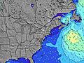 |  |  | ||||||||||||
Wave Height (m) Direction Period (s) | S 7 | SSE 8 | S 8 | SSE 7 | SSE 7 | SSE 7 | SE 7 | SSE 7 | SSE 7 | S 6 | SSE 6 | S 5 | S 6 | S 6 | S 4 | S 6 | S 6 | SSE 7 | S 6 |
Wave Graph | |||||||||||||||||||
200 | 250 | 341 | 101 | 44 | 32 | 143 | 91 | 96 | 88 | 48 | 95 | 123 | 49 | 33 | 49 | 26 | 57 | 91 | |
Wind (km/h) | |||||||||||||||||||
Wind State on-shore cross-onshore cross-shore cross-offshore off-shore glassy | cross-on | cross-on | cross | cross-off | cross-on | cross-on | on | cross | cross-on | cross | cross-on | cross-on | cross | cross | cross-on | cross | cross-off | cross-on | cross-off |
High Tide | 11:16PM1.32m | 11:49AM1.31m | 00:02AM1.26m | 12:35PM1.34m | 00:54AM1.20m | 1:26PM1.37m | 1:51AM1.15m | 2:22PM1.39m | 2:54AM1.12m | 3:24PM1.41m | 4:04AM1.11m | 4:33PM1.44m | |||||||
Low Tide | 5:43AM0.02m | 6:08PM0.18m | 6:18AM0.05m | 6:58PM0.22m | 7:02AM0.09m | 8:05PM0.24m | 7:59AM0.13m | 9:22PM0.23m | 9:12AM0.15m | 10:34PM0.18m | 10:25AM0.13m | 11:38PM0.11m | |||||||
— | 6:01 | — | — | 6:01 | — | — | 6:01 | — | — | 6:03 | — | — | 6:03 | — | — | 6:05 | — | — | |
8:08 | — | 8:07 | — | — | 8:07 | — | — | 8:06 | — | — | 8:05 | — | — | 8:04 | — | — | 8:02 | — | |
mm | 13 | 10 | 12 | 8 | — | — | 3 | 1 | 2 | 2 | — | — | — | — | — | 2 | — | 8 | 12 |
Temp °C | 25 | 25 | 25 | 26 | 24 | 24 | 24 | 24 | 26 | 26 | 27 | 28 | 27 | 29 | 30 | 27 | 28 | 29 | 27 |
Feels °C | 26 | 26 | 26 | 29 | 23 | 22 | 26 | 24 | 28 | 27 | 28 | 28 | 27 | 31 | 30 | 26 | 31 | 31 | 27 |
Swell 1 Height (m) Direction Period (s) | — | — | — | SSE 7 | SSE 7 | SSE 7 | — | SSE 7 | E 10 | — | — | E 11 | E 11 | S 6 | E 11 | E 10 | S 6 | E 9 | S 6 |
— | — | — | 101 | 44 | 32 | — | 91 | 2 | — | — | 2 | 2 | 49 | 2 | 2 | 26 | 1 | 50 | |
Swell 2 Height (m) Direction Period (s) | — | — | — | — | — | E 8 | NE 4 | E 8 | E 12 | E 13 | E 9 | E 11 | E 11 | E 11 | E 10 | E 10 | SE 8 | E 9 | SE 8 |
— | — | — | — | — | 1 | 5 | 1 | 3 | 3 | 2 | 2 | 2 | 2 | 2 | 2 | 16 | 1 | 9 | |
Swell 3 Height (m) Direction Period (s) | — | — | — | — | — | — | — | E 9 | E 8 | — | — | — | — | — | — | — | E 9 | — | E 8 |
— | — | — | — | — | — | — | 1 | 1 | — | — | — | — | — | — | — | 2 | — | 1 | |
Wind waves Height (m) Direction Period (s) | S 7 | SSE 8 | S 8 | — | ENE 4 | ENE 4 | SE 7 | WSW 4 | SSE 7 | S 6 | SSE 6 | S 5 | S 6 | — | S 4 | S 6 | — | SSE 7 | S 6 |
200 | 250 | 341 | — | 26 | 18 | 143 | 10 | 96 | 88 | 48 | 95 | 123 | — | 33 | 49 | — | 57 | 91 | |
Nearest Offshore or Glassy | |||||||||||||||||||
Distance (km) | 1040 | 1179 | 159 | 0 | 217 | 257 | 257 | 39 | 38 | 20 | 159 | 362 | 172 | 146 | 362 | 3 | 0 | 38 | 0 |
Best forecast wave conditions in New Jersey | |||||||||||||||||||
Best forecast wave conditions in United States | |||||||||||||||||||
Header Global | |||||||||||||||||||
- Map Icons:
 Break
Break Live Wave Height (m)
 Live Wind Speed (km/h)
 Surf Rating (10 Max)
 Ocean Swells (m)
- Wind Speed (km/h)
Latest Updates


FREE! Surf-Forecast.com widget for your website
The surf report / weather widget below is available to embed on third party websites free of charge and provides a summary of our Nuns Beach surf forecast. Simply grab the html code snippet that we provide and paste it into your own site. You can choose your preferred language and metric/imperial units for the surf forecast feed to suit users of your site. Click here to get the code.
Information about the Nuns Beach Surf forecast
The above surf forecast table for Nuns Beach provides essential information for determining whether the surfing conditions will be good over the next 16 days. A general guide to surfing at Nuns Beach can be found by selecting the local surf guide option on the grey menu. Our Nuns Beach surf forecast is unique since it includes wave energy (power) that defines the real feel of the surf rather than just the height or the period. If you surf the same spot (Nuns Beach) regularly then make a mental note of the wave energy from the surf forecast table each time you go. Very soon you may start to choose your surf days based on the wave energy alone combined with our forecast of favourable offshore wind conditions. Our star ratings will help here and of course you will also find the usual wave height and period predictions on our surf forecasts as well as a full break down of the swell components under our advanced users option (to reveal that, click the little Einstein character under the tide times).
Further information to help with frequently asked questions about our surf forecast for Nuns Beach may be found under the help tab on the top menu and also by moving your mouse over the question marks on the surf forecast table itself. Please always bear in mind that the forecast is for near-shore open water and local factors at each surf break influence the actual breaking wave height, such as the beach / reef profile, water depths offshore and shelter.
Nuns Beach is 33 km (20 miles) from Ocean City. If you plan a vacation in New Jersey, look for hotels and other accommodation in Ocean City. Ocean City has rooms for a wide range of budgets as well as car hire and transport links.
 Nearest