

Surf Forecasts:

How big are the waves at Tuckerman's today (02 Aug):
- Morning surf: Morning surf (02 Aug, local time) - 1.5ft (0.5m), 7s period with S swell.
- Afternoon surf: Afternoon surf (02 Aug, local time) - 1.5ft (0.4m), 7s period with S swell.
- Evening surf: Evening surf (02 Aug, local time) - 1.5ft (0.4m), 7s period with S swell.
The current surf forecast for Tuckerman's at 7PM is: 0.4m 7s primary swell from a South direction and 0.4m 7s secondary swell from a Southeast direction, 0.5m 4s secondary swell from a South direction (forecast issued at 01:00pm August 02). The wind direction is predicted to be cross-onshore.
| Time (EDT) & Date | Wave Height | Wave Period |
|---|---|---|
| Morning (02 Aug) | 1.5ft (0.5m) | 7s |
| Afternoon (02 Aug) | 1.5ft (0.4m) | 7s |
| Evening (02 Aug) | 1.5ft (0.4m) | 7s |
Table - waves today at Tuckerman's. (Swell directed towards the surf break)
Short Range ForecastHeavy rain (total 38mm), heaviest during Mon afternoon. Warm (max 25°C on Tue afternoon, min 21°C on Mon night). Winds decreasing (fresh winds from the SSW on Mon morning, calm by Tue morning). | |||||||||||||||||||||
Sun 2 | Monday 3 | Tuesday 4 | |||||||||||||||||||
11 AM | 2 PM | 5 PM | 8 PM | 11 PM | 2 AM | 5 AM | 8 AM | 11 AM | 2 PM | 5 PM | 8 PM | 11 PM | 2 AM | 5 AM | 8 AM | 11 AM | 2 PM | 5 PM | 8 PM | 11 PM | |
Swell Height Map | 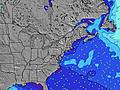 |  |  | 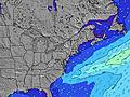 |  |  | 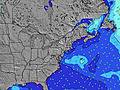 |  | |||||||||||||
Wave Height (m) Direction Period (s) | S 7 | S 7 | S 7 | S 7 | S 7 | S 5 | S 6 | S 7 | S 7 | S 9 | S 9 | S 9 | SSW 8 | S 8 | S 8 | S 8 | S 8 | S 8 | S 8 | S 7 | S 7 |
Wave Graph | |||||||||||||||||||||
25 | 15 | 15 | 14 | 15 | 24 | 64 | 124 | 242 | 470 | 440 | 487 | 864 | 266 | 187 | 127 | 99 | 94 | 72 | 69 | 51 | |
Wind (km/h) | |||||||||||||||||||||
Wind State on-shore cross-onshore cross-shore cross-offshore off-shore glassy | on | on | on | cross-on | on | on | on | on | cross-on | cross-on | cross-on | cross-on | glassy | off | off | off | glassy | on | on | on | cross-on |
High Tide | 10:53AM1.01m | 11:10PM0.99m | 11:37AM1.03m | 11:58PM0.95m | 12:25PM1.05m | ||||||||||||||||
Low Tide | 4:44PM0.10m | 4:59AM0.02m | 5:26PM0.12m | 5:36AM0.03m | 6:15PM0.16m | ||||||||||||||||
— | — | — | — | — | — | 5:41 | — | — | — | — | — | — | — | 5:41 | — | — | — | — | — | — | |
— | — | — | 8:00 | — | — | — | — | — | — | — | 8:00 | — | — | — | — | — | — | 7:59 | — | — | |
mm | — | — | — | — | — | 2 | 3 | 2 | 3 | 15 | 7 | 2 | 3 | — | — | — | — | — | — | — | — |
Temp °C | 24 | 24 | 24 | 23 | 23 | 23 | 23 | 23 | 23 | 22 | 22 | 22 | 23 | 21 | 21 | 21 | 24 | 25 | 24 | 24 | 23 |
Feels °C | 24 | 24 | 25 | 24 | 25 | 24 | 24 | 22 | 20 | 20 | 22 | 22 | 26 | 20 | 20 | 20 | 24 | 23 | 22 | 22 | 23 |
Swell 1 Height (m) Direction Period (s) | S 7 | S 7 | S 7 | S 7 | S 7 | S 6 | — | — | — | S 9 | — | — | S 9 | S 8 | S 8 | S 8 | S 8 | S 8 | S 8 | S 7 | S 7 |
25 | 15 | 15 | 14 | 14 | 7 | — | — | — | 470 | — | — | 377 | 266 | 187 | 127 | 99 | 94 | 72 | 69 | 51 | |
Swell 2 Height (m) Direction Period (s) | S 9 | S 9 | SE 7 | — | — | — | — | — | — | — | — | — | — | — | — | — | — | SE 7 | — | — | — |
2 | 2 | 12 | — | — | — | — | — | — | — | — | — | — | — | — | — | — | 37 | — | — | — | |
Swell 3 Height (m) Direction Period (s) | S 9 | S 9 | — | — | — | — | — | — | — | — | — | — | — | — | — | — | — | — | — | — | — |
2 | 2 | — | — | — | — | — | — | — | — | — | — | — | — | — | — | — | — | — | — | — | |
Wind waves Height (m) Direction Period (s) | S 4 | S 4 | S 4 | S 4 | S 4 | S 5 | S 6 | S 7 | S 7 | — | S 9 | S 9 | SSW 8 | — | — | — | — | — | — | — | — |
6 | 6 | 9 | 9 | 15 | 24 | 64 | 124 | 242 | — | 440 | 487 | 864 | — | — | — | — | — | — | — | — | |
Nearest Offshore or Glassy | |||||||||||||||||||||
Distance (km) | 1762 | 1613 | 1586 | 1541 | 155 | 1240 | 1352 | 254 | 1573 | 1573 | 43 | 109 | 0 | 0 | 0 | 0 | 0 | 43 | 19 | 19 | 19 |
Best forecast wave conditions in Rhode Island | |||||||||||||||||||||
Best forecast wave conditions in United States | |||||||||||||||||||||
Header Global | |||||||||||||||||||||
- Map Icons:
 Break
Break Live Wave Height (m)
 Live Wind Speed (km/h)
 Surf Rating (10 Max)
 Ocean Swells (m)
- Wind Speed (km/h)
Latest Updates


FREE! Surf-Forecast.com widget for your website
The surf report / weather widget below is available to embed on third party websites free of charge and provides a summary of our Tuckerman's surf forecast. Simply grab the html code snippet that we provide and paste it into your own site. You can choose your preferred language and metric/imperial units for the surf forecast feed to suit users of your site. Click here to get the code.
 Nearest