

Surf Forecasts:

Breachway surf forecast from 30 Jul 2026:
- Best quality surf: Wednesday 29 Jul, 11PM (local time) - 4ft (1.2m), 7s period, SSE swell with cross-offshore winds.
- Most powerful swell: Thursday 30 Jul, 2PM (local time) - 4ft (1.2m), 8s period, SSE swell with 176 kJ wave energy.
- Next surfable swell (1★+): Wednesday 29 Jul, 11PM (local time) - 4ft (1.2m), 7s period with SSE swell.
Best Forecast Surf Conditions for Breachway this week:
The surf forecast for Breachway over the next 16 days: The first swell (rated 1 star or higher) is forecast to arrive on Wednesday (Jul 29) at 11PM. The primary swell is predicted to be 1.2m and 7s period with a secondary swell of 0.4m and 5s. The wind is predicted to be cross-offshore as the swell arrives.
The most powerful waves expected at Breachway in the next 16 days are 1.2m 8s and forecast to arrive on Thursday (Jul 30) at 2PM. Winds are predicted to be offshore at the time the swell arrives. The largest open ocean swell (not directed at the beach) is 0.5m 5s period and expected on Thursday (Jul 30) at 5AM.
| Wave Type | Time (EDT) & Date | Wave Height & Period |
|---|---|---|
| Next good surf (1 star+) | 11PM (Wed 29th Jul) | 4ft (1.2m) 7s |
| Best Surf | 11PM (Wed 29th Jul) | 4ft (1.2m) 7s |
| Most Powerful | 2PM (Thu 30th Jul) | 4ft (1.2m) 8s |
Table - best surf conditions forecast for Breachway over the next 16 days.
The Lowdown
Alright, this is Rusty. Let’s get real about what’s coming up for Breachway. Looking at this whole 16-day stretch into mid-August, I gotta be straight with you – it’s a flat, frustrating run. There’s nothing that screams “get in the water now.” We’re looking at a long gap of small, weak, and messy conditions with barely a pulse.
The first real chance of anything is on Wednesday afternoon, July 29th, but it’s a tough sell. A small SSE swell is pushing in at 4 ft, but the period is a short, weak 6 seconds. The combined energy is a meager 133, and with a risk of thunderstorms and a southerly wind blowing onshore, it’s already choppy and junky. The water is sitting at 68°, which is a bit colder than usual for this time of year. Honestly, that afternoon is a write-off.
Thursday morning, July 30th, offers a glimmer of hope, but it’s a short window. The swell drops slightly to 3 ft from the SSE, still 8 seconds. The combined energy is 188. But the key here is a northerly offshore wind at 9 mph, making conditions clean. It’s surfable, but very ordinary. That offshore holds into the afternoon, picking up to 16 mph from the north, keeping things clean but the swell is already fading. That Thursday morning session is the only thing worth paddling out for.
Then we hit a grim patch. From Friday, July 31st, all the way through to the end of the outlook on Thursday, August 13th, it’s pretty much useless. Swell heights barely scrape 4 ft on a couple of days, but with dreadful 6-second period windswell, onshore and cross-onshore winds, and energy readings that mostly sit below 100 or just barely over it, it’s just not happening. A few days like Monday, August 3rd, have a spike in energy at 293, but it’s attached to a 5 ft, 6-second windswell and a cross-shore wind, which just means messy, lumpy lines. There’s nothing clean or powerful.
The last few days, August 10th into August 11th, get glassy or have light offshore winds, but the swell is practically gone—2 ft and 2 ft with energy in the 30s and 40s. You could float around but not surf.
So, to keep it simple: the only real window is Thursday morning, July 30th. That’s your one chance for a few barely surfable waves with clean conditions. Everything else in this 16-day forecast is a flat, windy, or choppy mess. Don’t get your hopes up.
Rusty.
Short Range ForecastModerate rain (total 17mm), heaviest on Wed afternoon. Warm (max 24°C on Sat morning, min 18°C on Thu morning). Wind will be generally light. | Days 5-7 Weather SummaryLight rain (total 9mm), mostly falling on Mon afternoon. Warm (max 25°C on Sat afternoon, min 19°C on Mon night). Wind will be generally light. | |||||||||||||||||||
Wed 29 | Thursday 30 | Friday 31 | Saturday 1 | Sunday 2 | Monday 3 | Tuesday 4 | ||||||||||||||
PM | Night | AM | PM | Night | AM | PM | Night | AM | PM | Night | AM | PM | Night | AM | PM | Night | AM | PM | Night | |
Swell Height Map | 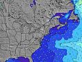 | 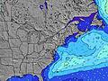 | 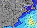 | 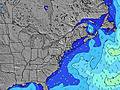 | 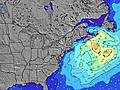 | 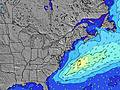 | 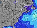 | |||||||||||||
Wave Height (m) Direction Period (s) | SSE 6 | SSE 7 | SSE 8 | S 8 | SSE 8 | SSE 8 | SSE 8 | S 8 | S 9 | S 8 | SSE 10 | S 8 | S 7 | S 7 | S 6 | S 7 | S 7 | S 7 | S 7 | S 7 |
Wave Graph | ||||||||||||||||||||
97 | 135 | 150 | 134 | 85 | 96 | 90 | 82 | 99 | 63 | 31 | 72 | 54 | 131 | 102 | 170 | 121 | 100 | 78 | 59 | |
Wind (km/h) | ||||||||||||||||||||
Wind State on-shore cross-onshore cross-shore cross-offshore off-shore glassy | on | cross-off | off | off | off | cross | on | cross-on | cross-on | on | cross-on | on | on | on | cross-on | cross | cross-off | cross | cross-on | cross |
High Tide | 9:23PM0.86m | 9:42AM0.78m | 9:57PM0.86m | 10:18AM0.80m | 10:33PM0.86m | 10:57AM0.82m | 11:12PM0.84m | 11:39AM0.83m | 11:56PM0.81m | 12:23PM0.84m | 00:44AM0.78m | 1:11PM0.86m | 1:35AM0.75m | |||||||
Low Tide | 3:06PM0.06m | 3:56AM0.05m | 3:48PM0.05m | 4:28AM0.03m | 4:27PM0.05m | 4:58AM0.02m | 5:05PM0.06m | 5:28AM0.01m | 5:45PM0.07m | 6:00AM0.02m | 6:27PM0.09m | 6:37AM0.02m | 7:16PM0.12m | |||||||
— | — | 5:39 | — | — | 5:41 | — | — | 5:41 | — | — | 5:43 | — | — | 5:43 | — | — | 5:45 | — | — | |
8:07 | — | — | 8:06 | — | — | 8:05 | — | — | 8:04 | — | — | 8:02 | — | — | 8:01 | — | — | 8:00 | — | |
mm | 6 | 4 | 6 | 1 | — | — | — | — | — | — | — | — | — | 1 | 3 | 5 | — | — | — | — |
Temp °C | 22 | 21 | 19 | 18 | 18 | 22 | 22 | 22 | 24 | 25 | 22 | 23 | 23 | 23 | 23 | 23 | 23 | 24 | 25 | 24 |
Feels °C | 23 | 23 | 19 | 17 | 16 | 22 | 21 | 22 | 24 | 25 | 22 | 23 | 23 | 24 | 23 | 24 | 24 | 23 | 22 | 22 |
Swell 1 Height (m) Direction Period (s) | SSE 6 | SSE 7 | SSE 8 | S 8 | SSE 8 | SSE 8 | SSE 8 | S 8 | S 9 | S 8 | S 8 | S 8 | S 7 | SE 9 | S 7 | S 7 | S 7 | S 7 | S 7 | S 7 |
97 | 135 | 150 | 134 | 85 | 96 | 90 | 82 | 99 | 63 | 28 | 72 | 54 | 3 | 10 | 123 | 121 | 100 | 78 | 59 | |
Swell 2 Height (m) Direction Period (s) | SSW 6 | E 5 | S 7 | E 5 | E 6 | E 6 | E 6 | E 6 | SE 9 | SE 9 | SSE 10 | SE 9 | SE 9 | — | — | — | — | SE 8 | SE 8 | SE 8 |
25 | 9 | 34 | 2 | 2 | 1 | 1 | 1 | 3 | 3 | 31 | 3 | 3 | — | — | — | — | 3 | 3 | 10 | |
Swell 3 Height (m) Direction Period (s) | E 5 | — | S 8 | — | E 6 | — | E 6 | SE 10 | E 6 | E 5 | SE 7 | ESE 9 | SE 9 | — | — | — | — | — | — | — |
11 | — | 4 | — | 3 | — | 3 | 4 | 1 | 1 | 8 | 8 | 3 | — | — | — | — | — | — | — | |
Wind waves Height (m) Direction Period (s) | — | — | ENE 6 | N 3 | NNE 4 | — | SW 2 | SW 3 | — | S 4 | S 4 | — | S 4 | S 7 | S 6 | SSW 6 | — | — | SW 3 | SSW 4 |
— | — | 6 | 4 | 2 | — | 1 | 2 | — | 6 | 8 | — | 4 | 131 | 102 | 170 | — | — | 2 | 11 | |
Nearest Offshore or Glassy | ||||||||||||||||||||
Distance (km) | 10 | 0 | 0 | 0 | 0 | 1 | 10 | 10 | 10 | 778 | 26 | 778 | 1492 | 10 | 205 | 26 | 0 | 1 | 10 | 1 |
Best forecast wave conditions in Rhode Island | ||||||||||||||||||||
Best forecast wave conditions in United States | ||||||||||||||||||||
Header Global | ||||||||||||||||||||
- Map Icons:
 Break
Break Live Wave Height (m)
 Live Wind Speed (km/h)
 Surf Rating (10 Max)
 Ocean Swells (m)
- Wind Speed (km/h)


FREE! Surf-Forecast.com widget for your website
The surf report / weather widget below is available to embed on third party websites free of charge and provides a summary of our Breachway surf forecast. Simply grab the html code snippet that we provide and paste it into your own site. You can choose your preferred language and metric/imperial units for the surf forecast feed to suit users of your site. Click here to get the code.
Information about the Breachway Surf forecast
The above surf forecast table for Breachway provides essential information for determining whether the surfing conditions will be good over the next 16 days. A general guide to surfing at Breachway can be found by selecting the local surf guide option on the grey menu. Our Breachway surf forecast is unique since it includes wave energy (power) that defines the real feel of the surf rather than just the height or the period. If you surf the same spot (Breachway) regularly then make a mental note of the wave energy from the surf forecast table each time you go. Very soon you may start to choose your surf days based on the wave energy alone combined with our forecast of favourable offshore wind conditions. Our star ratings will help here and of course you will also find the usual wave height and period predictions on our surf forecasts as well as a full break down of the swell components under our advanced users option (to reveal that, click the little Einstein character under the tide times).
Further information to help with frequently asked questions about our surf forecast for Breachway may be found under the help tab on the top menu and also by moving your mouse over the question marks on the surf forecast table itself. Please always bear in mind that the forecast is for near-shore open water and local factors at each surf break influence the actual breaking wave height, such as the beach / reef profile, water depths offshore and shelter.
Breachway is 9 km (6 miles) from Westerly. If you plan a vacation in Rhode Island, look for hotels and other accommodation in Westerly. Westerly has rooms for a wide range of budgets as well as car hire and transport links.
 Nearest