

Surf Forecasts:

Tourmaline surf forecast from 9 Jul 2026:
- Best quality surf: Thursday 9 Jul, 5AM (local time) - 3.5ft (1.0m), 16s period, SW swell with glassy winds.
- Most powerful swell: Thursday 9 Jul, 2AM (local time) - 3.5ft (1.0m), 16s period, SW swell with 527 kJ wave energy.
- Next surfable swell (1★+): Thursday 9 Jul, 5AM (local time) - 3.5ft (1.0m), 16s period with SW swell.
Best Forecast Surf Conditions for Tourmaline this week:
The surf forecast for Tourmaline over the next 16 days: The first swell (rated 1 star or higher) is forecast to arrive on Thursday (Jul 09) at 5AM. The primary swell is predicted to be 1.0m and 16s period with a secondary swell of 1.1m and 8s. The wind is predicted to be glassy as the swell arrives.
The most powerful waves expected at Tourmaline in the next 16 days are 1.0m 16s and forecast to arrive on Thursday (Jul 09) at 2AM. Winds are predicted to be onshore at the time the swell arrives.
| Wave Type | Time (PDT) & Date | Wave Height & Period |
|---|---|---|
| Next good surf (1 star+) | 5AM (Thu 9th Jul) | 3.5ft (1.0m) 16s |
| Best Surf | 5AM (Thu 9th Jul) | 3.5ft (1.0m) 16s |
| Most Powerful | 2AM (Thu 9th Jul) | 3.5ft (1.0m) 16s |
Table - best surf conditions forecast for Tourmaline over the next 16 days.
Alright folks, Rusty here, and I’ve been staring at the charts for our local lineup. Let’s be real – it’s a bit of a slow start. We’ve got a long stretch of marginal conditions coming up, but there’s a pulse of proper energy lurking way out in the back half of the forecast that’s got my attention for the patient ones.
The pattern starts off quiet. We’re looking at Tourmaline, which is our only option on the cards, and for the first week and a half, it’s pretty grim. The water is sitting at 70°F at the start, which is much warmer than usual for this time of year, so at least you won’t need a thick suit.
The first window of anything worth paddling out for looks like it’s going to be a bit of a long shot. From Wednesday afternoon, July 8th, through the following week, we’re stuck with weak, messy conditions. Wave heights are tiny, mostly around 3 feet, and the wind is cross-on or onshore. The combined energy is weak, staying in the low hundreds (557), and the period is either too short or just not organized. The reports are all "poor" or "marginal" – it’s just not worth getting wet.
We hit a bit of a dead zone. The mornings and afterdays from July 9th through July 18th are all rated poorly. There’s a short period on July 14th afternoon where the wind goes cross-shore, but the swell is a pathetic 2 feet with a high period of 18 seconds, which will just slide past without any push. That’s a kite-surfing kind of day, not for a paddle.
Now, hold on, because the end of the run is where it gets interesting. On Sunday, July 19th, we finally see some grunt. The swell jumps up, with the morning seeing 4 feet from the South and the afternoon building to 5 feet. The combined energy goes through the roof – 1071 in the morning and a massive 1567 in the afternoon. That’s a solid pulse of energy. The period is a long 16 seconds, which is proper groundswell. The wind is light and cross-onshore, so it’s not perfect, but it’s rideable.
The standout moment is the afternoon of July 19th. Tourmaline is a reef break, and with that 5-foot South swell and 16-second period, it’s going to get some nice lines. The wind is light, so it’ll be a bit lumpy but not blown out. Keep in mind, with a long period like that, the sets will be slower and more powerful, and the reef will handle it better than a beach break. Crowds are often here, so expect company.
The energy carries into Monday, July 20th. The swell holds at 6 feet with a 14-second period, but the combined energy drops to 1153. It’s still a solid size, but it might be pushing the limits for beginners. The wind looks a bit better in the morning (light onshore), but by afternoon the cross-onshore comes up and makes it choppy.
After that, it fades fast. Tuesday, July 21st, the swell drops back to 3 feet, and the energy is back to weak (640). The rest of the week into July 23rd is just small, weak, and not worth the drive.
So, the bottom line: The first 11 days are a bust. Don’t bother. The best bet is the afternoon of July 19th at Tourmaline. That’s your standout. The morning of July 20th is also a good call for the bigger swell, but it’s a bit more raw. For the rest of the run, save your wax.
Rusty.
Short Range ForecastMostly dry. Warm (max 21°C on Fri afternoon, min 17°C on Wed night). Wind will be generally light. | Days 5-7 Weather SummaryMostly dry. Warm (max 22°C on Mon morning, min 19°C on Sat night). Wind will be generally light. | ||||||||||||||||||||
Thursday 9 | Friday 10 | Saturday 11 | Sunday 12 | Monday 13 | Tuesday 14 | Wed 15 | |||||||||||||||
Night | AM | PM | Night | AM | PM | Night | AM | PM | Night | AM | PM | Night | AM | PM | Night | AM | PM | Night | AM | PM | |
Swell Height Map |  |  |  |  |  |  |  | 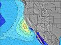 | |||||||||||||
Wave Height (m) Direction Period (s) | SW 16 | SW 16 | SW 16 | SW 16 | SW 15 | SW 15 | SW 15 | SW 15 | SW 15 | SW 14 | SSW 14 | SSW 14 | SSW 14 | SSW 13 | SW 13 | SW 13 | SSW 12 | SW 18 | SW 18 | WNW 9 | W 9 |
Wave Graph | |||||||||||||||||||||
527 | 432 | 421 | 489 | 322 | 309 | 309 | 314 | 318 | 288 | 362 | 367 | 318 | 309 | 140 | 183 | 136 | 154 | 194 | 129 | 165 | |
Wind (km/h) | |||||||||||||||||||||
Wind State on-shore cross-onshore cross-shore cross-offshore off-shore glassy | on | cross-on | on | cross-on | cross-on | on | cross-on | cross-on | cross-on | glassy | on | cross-on | glassy | cross-on | cross-on | glassy | on | cross-on | cross-on | cross-on | on |
High Tide | 5:56AM0.90m | 5:23PM1.78m | 7:26AM0.96m | 6:18PM1.93m | 8:29AM1.06m | 7:12PM2.07m | 9:18AM1.16m | 8:04PM2.17m | 10:01AM1.23m | 8:55PM2.23m | 10:42AM1.30m | 9:43PM2.21m | 11:22AM1.36m | ||||||||
Low Tide | 00:14AM0.28m | 10:42AM0.63m | 1:19AM0.04m | 11:53AM0.71m | 2:12AM-0.19m | 1:00PM0.72m | 3:01AM-0.37m | 2:00PM0.68m | 3:46AM-0.49m | 2:55PM0.62m | 4:30AM-0.53m | 3:48PM0.57m | 5:12AM-0.50m | 4:39PM0.53m | |||||||
— | 5:48 | — | — | 5:48 | — | — | 5:48 | — | — | 5:48 | — | — | 5:50 | — | — | 5:50 | — | — | 5:50 | — | |
8:00 | — | 8:00 | — | — | 7:59 | — | — | 7:59 | — | — | 7:59 | — | — | 7:58 | — | — | 7:58 | — | — | 7:58 | |
mm | — | — | — | — | — | — | — | — | — | — | — | — | — | — | — | — | — | — | — | — | 2 |
Temp °C | 18 | 19 | 20 | 19 | 20 | 21 | 19 | 20 | 20 | 19 | 20 | 21 | 21 | 22 | 21 | 21 | 21 | 22 | 22 | 23 | 23 |
Feels °C | 18 | 18 | 19 | 20 | 18 | 20 | 19 | 19 | 19 | 20 | 20 | 21 | 22 | 22 | 20 | 22 | 22 | 22 | 23 | 23 | 24 |
Swell 1 Height (m) Direction Period (s) | W 8 | W 9 | W 9 | SW 16 | SW 15 | SW 15 | SW 15 | SW 15 | SW 15 | SW 14 | SSW 14 | SSW 14 | SSW 14 | SSW 13 | SW 13 | SW 13 | SSW 12 | SW 13 | W 8 | WNW 9 | W 9 |
117 | 186 | 136 | 489 | 322 | 309 | 309 | 314 | 318 | 288 | 362 | 367 | 318 | 309 | 140 | 183 | 136 | 79 | 46 | 129 | 165 | |
Swell 2 Height (m) Direction Period (s) | SW 16 | SW 16 | SW 16 | W 9 | W 8 | W 9 | W 9 | W 9 | W 9 | W 8 | WNW 8 | WNW 9 | WNW 9 | WNW 9 | S 14 | SW 19 | WNW 8 | W 9 | SW 18 | WSW 18 | SSW 12 |
527 | 432 | 421 | 87 | 92 | 85 | 59 | 42 | 57 | 33 | 24 | 16 | 26 | 16 | 101 | 133 | 23 | 41 | 194 | 120 | 57 | |
Swell 3 Height (m) Direction Period (s) | — | S 9 | S 10 | — | — | S 21 | — | SSW 20 | S 20 | SSW 18 | W 24 | SW 21 | WSW 21 | SW 21 | WNW 9 | WNW 9 | SW 19 | SW 18 | SSW 13 | SW 13 | SW 16 |
— | 2 | 2 | — | — | 9 | — | 37 | 7 | 60 | 11 | 18 | 45 | 18 | 17 | 27 | 93 | 154 | 113 | 83 | 130 | |
Wind waves Height (m) Direction Period (s) | — | — | — | — | — | — | — | — | — | — | — | — | — | — | — | — | — | — | — | — | — |
— | — | — | — | — | — | — | — | — | — | — | — | — | — | — | — | — | — | — | — | — | |
Nearest Offshore or Glassy | |||||||||||||||||||||
Distance (km) | 15 | 7 | 63 | 63 | 6 | 129 | 7 | 7 | 63 | 62 | 6 | 7 | 112 | 0 | 16 | 16 | 1 | 16 | 16 | 5 | 16 |
Best forecast wave conditions in San Diego County | |||||||||||||||||||||
Best forecast wave conditions in United States | |||||||||||||||||||||
Header Global | |||||||||||||||||||||
- Map Icons:
 Break
Break Live Wave Height (m)
 Live Wind Speed (km/h)
 Surf Rating (10 Max)
 Ocean Swells (m)
- Wind Speed (km/h)


FREE! Surf-Forecast.com widget for your website
The surf report / weather widget below is available to embed on third party websites free of charge and provides a summary of our Tourmaline surf forecast. Simply grab the html code snippet that we provide and paste it into your own site. You can choose your preferred language and metric/imperial units for the surf forecast feed to suit users of your site. Click here to get the code.
Information about the Tourmaline Surf forecast
The above surf forecast table for Tourmaline provides essential information for determining whether the surfing conditions will be good over the next 16 days. A general guide to surfing at Tourmaline can be found by selecting the local surf guide option on the grey menu. Our Tourmaline surf forecast is unique since it includes wave energy (power) that defines the real feel of the surf rather than just the height or the period. If you surf the same spot (Tourmaline) regularly then make a mental note of the wave energy from the surf forecast table each time you go. Very soon you may start to choose your surf days based on the wave energy alone combined with our forecast of favourable offshore wind conditions. Our star ratings will help here and of course you will also find the usual wave height and period predictions on our surf forecasts as well as a full break down of the swell components under our advanced users option (to reveal that, click the little Einstein character under the tide times).
Further information to help with frequently asked questions about our surf forecast for Tourmaline may be found under the help tab on the top menu and also by moving your mouse over the question marks on the surf forecast table itself. Please always bear in mind that the forecast is for near-shore open water and local factors at each surf break influence the actual breaking wave height, such as the beach / reef profile, water depths offshore and shelter.
Tourmaline is 9 km (6 miles) from San Diego. If you plan a vacation in San Diego County, look for hotels and other accommodation in San Diego. San Diego has rooms for a wide range of budgets as well as car hire and transport links.
 Nearest