

Surf Forecasts:

Montauk Point - Turtles surf forecast from 2 Aug 2026:
- Best quality surf: Tuesday 4 Aug, 2AM (local time) - 6.5ft (2.0m), 8s period, S swell with cross-offshore winds.
- Most powerful swell: Monday 3 Aug, 2PM (local time) - 10ft (3.0m), 8s period, S swell with 1,046 kJ wave energy.
- Next surfable swell (1★+): Tuesday 4 Aug, 2AM (local time) - 6.5ft (2.0m), 8s period with S swell.
Best Forecast Surf Conditions for Montauk Point - Turtles this week:
The surf forecast for Montauk Point - Turtles over the next 16 days: The first swell (rated 1 star or higher) is forecast to arrive on Tuesday (Aug 04) at 2AM. The primary swell is predicted to be 2.0m and 8s period. The wind is predicted to be cross-offshore as the swell arrives.
The most powerful waves expected at Montauk Point - Turtles in the next 16 days are 3.0m 8s and forecast to arrive on Monday (Aug 03) at 2PM. Winds are predicted to be cross-shore at the time the swell arrives. The largest open ocean swell (not directed at the beach) is 0.4m 3s period and expected on Tuesday (Aug 04) at 5AM.
| Wave Type | Time (EDT) & Date | Wave Height & Period |
|---|---|---|
| Next good surf (1 star+) | 2AM (Tue 4th Aug) | 6.5ft (2.0m) 8s |
| Best Surf | 2AM (Tue 4th Aug) | 6.5ft (2.0m) 8s |
| Most Powerful | 2PM (Mon 3rd Aug) | 10ft (3.0m) 8s |
Table - best surf conditions forecast for Montauk Point - Turtles over the next 16 days.
The Lowdown
Alright folks, Rusty here. Let’s have a look at what’s on the menu for Montauk Point – Turtles. This is a reef setup that needs a good southerly angle to fire, and it’s exposed to the open ocean. The water is running a bit colder than normal for this time of year, sitting at 68°, so you might want a spring suit if you’re heading out.
The first half of this 16-day window is a tough slog. From Sunday the 2nd right through to the end of the first week, we’re looking at a whole lot of nothing. The wind is mostly cross or cross-onshore, gusty, and the swell is either tiny, short-period, or just plain messy. The combined swell energy is weak, often under 100. It’s a write-off.
We finally get a brief window of hope on Tuesday morning, the 4th. The wind swings around to the northwest, glassy as can be, and the swell comes up to 5 ft from the south with a period of 8 seconds. The combined energy hits 247, which is moderate. This is the standout moment. The water will be clean, the waves will have some shape, and the crowd factor is there, but with conditions this good, you’ll be happy to share the lineup. This is the best on offer.
After that, the wind shifts back onshore or cross-shore again, and the swell drops off. The 8th of August morning shows a small clean window with 3 ft swell and light offshore wind, but the energy is low. It’s surfable, but it’s not going to get your heart racing.
The second week is a bit of a mixed bag. The 11th has a morning with clean conditions and 4 ft swell, but the period is short and the energy is only 151. The 15th and 16th have some swell, but the wind is onshore or cross, making it messy. For the most part, the energy stays low, and the quality is poor. There’s a small window on the 16th morning with 4 ft swell and clean conditions, but it’s nothing special.
In short, you’ve got one real shot: Tuesday the 4th, early morning. Get there before the wind turns. Otherwise, it’s a long wait for the next decent swell.
Rusty.
Short Range ForecastModerate rain (total 17mm), heaviest on Sun night. Warm (max 25°C on Mon morning, min 21°C on Mon night). Winds decreasing (strong winds from the SSW on Mon morning, calm by Tue morning). | Days 4-6 Weather SummaryModerate rain (total 12mm), heaviest on Fri night. Warm (max 26°C on Fri morning, min 23°C on Wed morning). Mainly fresh winds. | ||||||||||||||||||||
Sunday 2 | Monday 3 | Tuesday 4 | Wednesday 5 | Thursday 6 | Friday 7 | Saturday 8 | |||||||||||||||
AM | PM | Night | AM | PM | Night | AM | PM | Night | AM | PM | Night | AM | PM | Night | AM | PM | Night | AM | PM | Night | |
Swell Height Map | 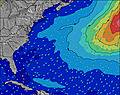 | 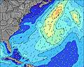 | 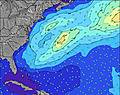 | 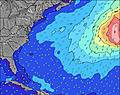 | 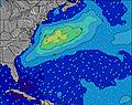 | 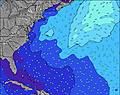 | 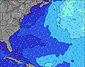 | ||||||||||||||
Wave Height (m) Direction Period (s) | S 7 | SSW 7 | S 5 | S 8 | S 9 | S 8 | S 8 | S 8 | SSW 7 | SSW 7 | SSW 7 | SSW 6 | SSW 6 | SSW 6 | SSW 7 | SSW 7 | SSW 6 | SSW 6 | SSW 6 | SSW 6 | SSW 6 |
Wave Graph | |||||||||||||||||||||
25 | 17 | 57 | 806 | 993 | 546 | 247 | 163 | 71 | 65 | 158 | 85 | 145 | 182 | 316 | 171 | 140 | 127 | 85 | 68 | 71 | |
Wind (km/h) | |||||||||||||||||||||
Wind State on-shore cross-onshore cross-shore cross-offshore off-shore glassy | cross-on | cross-on | cross-on | cross-on | cross | cross-off | glassy | cross | cross-on | cross-on | cross | cross | cross | cross | cross | cross | cross | cross | cross-off | cross | cross |
High Tide | 10:47AM0.84m | 10:53PM0.80m | 11:24AM0.86m | 11:36PM0.76m | 12:08PM0.87m | 00:24AM0.72m | 12:59PM0.88m | 1:20AM0.68m | 1:59PM0.89m | 2:26AM0.65m | 3:09PM0.90m | 3:44AM0.66m | 4:31PM0.93m | ||||||||
Low Tide | 4:38PM0.11m | 4:55AM0.03m | 5:27PM0.13m | 5:36AM0.05m | 6:22PM0.15m | 6:22AM0.07m | 7:27PM0.17m | 7:17AM0.09m | 8:46PM0.17m | 8:21AM0.10m | 10:10PM0.14m | 9:33AM0.09m | 11:19PM0.09m | ||||||||
5:43 | — | — | 5:43 | — | — | 5:45 | — | — | 5:46 | — | — | 5:47 | — | — | 5:48 | — | — | 5:48 | — | — | |
— | 8:02 | — | — | 8:00 | — | — | 8:00 | — | — | 7:59 | — | — | 7:58 | — | — | 7:57 | — | — | 7:54 | — | |
mm | — | — | 6 | 3 | 4 | 4 | — | — | — | 4 | — | — | — | — | 1 | — | — | 7 | — | — | — |
Temp °C | 23 | 24 | 24 | 25 | 24 | 23 | 23 | 25 | 25 | 25 | 24 | 24 | 24 | 25 | 25 | 26 | 26 | 24 | 24 | 25 | 25 |
Feels °C | 23 | 24 | 25 | 21 | 22 | 21 | 23 | 23 | 22 | 25 | 23 | 23 | 24 | 25 | 25 | 27 | 26 | 27 | 27 | 26 | 25 |
Swell 1 Height (m) Direction Period (s) | S 7 | SSW 7 | SE 9 | — | — | S 8 | S 8 | S 8 | SSW 7 | SSW 7 | S 7 | SE 7 | E 10 | E 11 | SE 8 | SE 8 | SE 8 | SE 8 | SSW 6 | SE 8 | SE 7 |
25 | 15 | 3 | — | — | 546 | 247 | 163 | 71 | 65 | 138 | 17 | 2 | 2 | 9 | 9 | 10 | 23 | 85 | 31 | 14 | |
Swell 2 Height (m) Direction Period (s) | SE 7 | SE 7 | — | — | — | — | — | — | SE 7 | SE 7 | E 10 | E 10 | — | E 10 | E 9 | — | E 9 | E 9 | SE 8 | E 8 | E 8 |
16 | 16 | — | — | — | — | — | — | 36 | 36 | 2 | 2 | — | 2 | 2 | — | 2 | 2 | 31 | 1 | 1 | |
Swell 3 Height (m) Direction Period (s) | S 9 | S 8 | — | — | — | — | — | — | E 12 | E 10 | — | — | — | — | — | — | — | — | E 8 | — | — |
6 | 1 | — | — | — | — | — | — | 3 | 2 | — | — | — | — | — | — | — | — | 1 | — | — | |
Wind waves Height (m) Direction Period (s) | S 4 | S 4 | S 5 | S 8 | S 9 | — | — | — | — | — | SSW 7 | SSW 6 | SSW 6 | SSW 6 | SSW 7 | SSW 7 | SSW 6 | SSW 6 | — | SSW 6 | SSW 6 |
13 | 17 | 57 | 806 | 993 | — | — | — | — | — | 158 | 85 | 145 | 182 | 316 | 171 | 140 | 127 | — | 68 | 71 | |
Nearest Offshore or Glassy | |||||||||||||||||||||
Distance (km) | 791 | 1660 | 1202 | 192 | 192 | 0 | 0 | 2 | 0 | 658 | 645 | 30 | 645 | 30 | 192 | 30 | 30 | 26 | 0 | 375 | 30 |
Best forecast wave conditions in Long Island New York | |||||||||||||||||||||
Best forecast wave conditions in United States | |||||||||||||||||||||
Header Global | |||||||||||||||||||||
- Map Icons:
 Break
Break Live Wave Height (m)
 Live Wind Speed (km/h)
 Surf Rating (10 Max)
 Ocean Swells (m)
- Wind Speed (km/h)
Latest Updates


FREE! Surf-Forecast.com widget for your website
The surf report / weather widget below is available to embed on third party websites free of charge and provides a summary of our Montauk Point - Turtles surf forecast. Simply grab the html code snippet that we provide and paste it into your own site. You can choose your preferred language and metric/imperial units for the surf forecast feed to suit users of your site. Click here to get the code.
Information about the Montauk Point - Turtles Surf forecast
The above surf forecast table for Montauk Point - Turtles provides essential information for determining whether the surfing conditions will be good over the next 16 days. A general guide to surfing at Montauk Point - Turtles can be found by selecting the local surf guide option on the grey menu. Our Montauk Point - Turtles surf forecast is unique since it includes wave energy (power) that defines the real feel of the surf rather than just the height or the period. If you surf the same spot (Montauk Point - Turtles) regularly then make a mental note of the wave energy from the surf forecast table each time you go. Very soon you may start to choose your surf days based on the wave energy alone combined with our forecast of favourable offshore wind conditions. Our star ratings will help here and of course you will also find the usual wave height and period predictions on our surf forecasts as well as a full break down of the swell components under our advanced users option (to reveal that, click the little Einstein character under the tide times).
Further information to help with frequently asked questions about our surf forecast for Montauk Point - Turtles may be found under the help tab on the top menu and also by moving your mouse over the question marks on the surf forecast table itself. Please always bear in mind that the forecast is for near-shore open water and local factors at each surf break influence the actual breaking wave height, such as the beach / reef profile, water depths offshore and shelter.
Montauk Point - Turtles is 34 km (21 miles) from Westerly. If you plan a vacation in Long Island New York, look for hotels and other accommodation in Westerly. Westerly has rooms for a wide range of budgets as well as car hire and transport links.
 Nearest