

Surf Forecasts:

Cocoa Beach Pier surf forecast from 5 Jul 2026:
- Best quality surf: Thursday 9 Jul, 11AM (local time) - 1.5ft (0.5m), 9s period, ESE swell with glassy winds.
- Most powerful swell: Saturday 11 Jul, 2AM (local time) - 2.5ft (0.8m), 8s period, ESE swell with 84 kJ wave energy.
- Next surfable swell (1★+): Thursday 9 Jul, 11AM (local time) - 1.5ft (0.5m), 9s period with ESE swell.
Best Forecast Surf Conditions for Cocoa Beach Pier this week:
The surf forecast for Cocoa Beach Pier over the next 16 days: The first swell (rated 1 star or higher) is forecast to arrive on Thursday (Jul 09) at 11AM. The primary swell is predicted to be 0.5m and 9s period with a secondary swell of 0.4m and 4s. The wind is predicted to be glassy as the swell arrives.
The most powerful waves expected at Cocoa Beach Pier in the next 16 days are 0.8m 8s and forecast to arrive on Saturday (Jul 11) at 2AM. Winds are predicted to be cross-shore at the time the swell arrives. The largest open ocean swell (not directed at the beach) is 0.3m 3s period and expected on Monday (Jul 06) at 5AM.
| Wave Type | Time (EDT) & Date | Wave Height & Period |
|---|---|---|
| Next good surf (1 star+) | 11AM (Thu 9th Jul) | 1.5ft (0.5m) 9s |
| Best Surf | 11AM (Thu 9th Jul) | 1.5ft (0.5m) 9s |
| Most Powerful | 2AM (Sat 11th Jul) | 2.5ft (0.8m) 8s |
Table - best surf conditions forecast for Cocoa Beach Pier over the next 16 days.
Updates in hr min s Forecast update imminent
Alright folks, Rusty here. Let me be straight with you – it’s gonna be a quiet stretch for Cocoa Beach Pier. For the next 16 days starting from now, there’s really nothing to get excited about.
Water temps are hanging around `85°F`, which is a touch warmer than average for this time of year, but with no real swell pushing through, that’s just comfort for a swim, not a surf.
The whole 16-day window is pretty much a write-off. We’re looking at wave heights consistently under `2ft` and mostly coming from the ESE or E with short periods of `8 to 10 seconds`. The combined swell energy barely cracks double digits, sitting mostly between `7` and `70` – that’s weak energy, no way around it. It’s just not enough to push anything rideable.
There are a few mornings where the wind turns offshore or even goes glassy – like on Tuesday 7th July morning with a `3 mph` glassy wind, or Thursday 9th July morning with that same glassy feel. The surf will look clean, but at `1.0ft` to `2ft`, it’s barely a ripple. You’d be fighting for any kind of glide, and honestly, it’s more of a paddleboard or swim kind of day.
Because the swell is so weak and the period is short, this isn’t even really a beginner wave – it’s just flat. If you’re desperate for any time on the water, a longboard or a foil might keep you amused, but for a proper surf? Not this week, and not the next.
Overall, the whole 16 days is a blank run. For Cocoa Beach Pier, this kind of flat spell is pretty normal when the summer pattern stalls out. Forecasts can always change, but right now, there’s nothing on the table.
Stay patient, keep the board waxed, and wait for the next pulse.
– Rusty
Short Range ForecastHeavy rain (total 27mm), heaviest during Sun afternoon. Warm (max 31°C on Mon afternoon, min 26°C on Mon morning). Wind will be generally light. | Days 5-7 Weather SummaryModerate rain (total 15mm), heaviest on Wed night. Warm (max 30°C on Wed afternoon, min 25°C on Sat morning). Wind will be generally light. | ||||||||||||||||||||
Sun 5 | Monday 6 | Tuesday 7 | Wednesday 8 | Thursday 9 | Friday 10 | Saturday 11 | |||||||||||||||
PM | Night | AM | PM | Night | AM | PM | Night | AM | PM | Night | AM | PM | Night | AM | PM | Night | AM | PM | Night | AM | |
Swell Height Map | 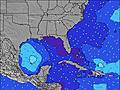 | 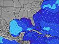 | 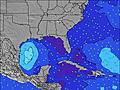 | 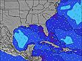 | 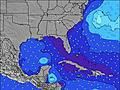 | 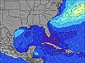 | 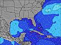 | 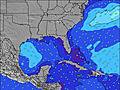 | |||||||||||||
Wave Height (m) Direction Period (s) | ESE 8 | E 8 | ESE 8 | ESE 8 | E 8 | E 9 | ESE 9 | ESE 8 | E 8 | E 8 | ESE 9 | ESE 9 | ESE 9 | ESE 9 | ESE 8 | E 8 | ESE 8 | ESE 8 | ESE 8 | ESE 8 | ESE 8 |
Wave Graph | |||||||||||||||||||||
13 | 11 | 13 | 21 | 11 | 14 | 25 | 22 | 37 | 37 | 28 | 47 | 64 | 25 | 24 | 35 | 84 | 37 | 21 | 35 | 20 | |
Wind (km/h) | |||||||||||||||||||||
Wind State on-shore cross-onshore cross-shore cross-offshore off-shore glassy | cross-on | cross-off | off | cross-on | cross-off | glassy | cross-on | cross | cross-off | cross-on | cross-off | glassy | cross-on | cross | cross | cross-on | cross | glassy | cross-on | cross-off | off |
High Tide | 00:33AM1.02m | 1:08PM0.94m | 1:18AM0.97m | 1:59PM1.01m | 2:06AM0.92m | 2:57PM1.09m | 3:02AM0.88m | 4:00PM1.17m | 4:06AM0.86m | 5:00PM1.25m | 5:06AM0.87m | 5:56PM1.32m | 6:05AM0.89m | ||||||||
Low Tide | 6:16PM0.14m | 6:53AM0.02m | 7:12PM0.16m | 7:36AM-0.03m | 8:09PM0.16m | 8:22AM-0.07m | 9:12PM0.16m | 9:14AM-0.11m | 10:19PM0.13m | 10:11AM-0.15m | 11:21PM0.09m | 11:09AM-0.19m | 00:21AM0.05m | 12:06PM-0.22m | |||||||
— | — | 6:30 | — | — | 6:31 | — | — | 6:31 | — | — | 6:31 | — | — | 6:31 | — | — | 6:33 | — | — | 6:33 | |
8:22 | — | — | 8:22 | — | — | 8:22 | — | — | 8:22 | — | — | 8:22 | — | — | 8:22 | — | — | 8:22 | — | 8:22 | |
mm | 11 | 2 | — | 3 | 3 | — | 1 | 7 | — | 3 | 7 | — | — | 4 | — | — | 1 | — | — | 1 | — |
Temp °C | 29 | 29 | 27 | 31 | 30 | 28 | 30 | 30 | 28 | 30 | 29 | 28 | 30 | 29 | 28 | 30 | 28 | 28 | 30 | 29 | 29 |
Feels °C | 32 | 30 | 30 | 33 | 32 | 32 | 33 | 32 | 32 | 33 | 30 | 32 | 33 | 30 | 33 | 33 | 30 | 33 | 33 | 31 | 32 |
Swell 1 Height (m) Direction Period (s) | ESE 8 | SE 4 | SE 4 | ESE 8 | E 8 | E 9 | ESE 9 | ESE 8 | E 8 | E 8 | ESE 9 | ESE 9 | E 12 | ESE 9 | ESE 4 | E 11 | ESE 8 | ESE 8 | ESE 8 | ESE 8 | ESE 8 |
13 | 4 | 3 | 21 | 11 | 14 | 25 | 22 | 37 | 37 | 28 | 47 | 3 | 25 | 8 | 2 | 38 | 37 | 21 | 35 | 20 | |
Swell 2 Height (m) Direction Period (s) | NE 6 | E 8 | ESE 8 | E 7 | E 6 | ESE 4 | E 7 | — | — | — | E 13 | SSE 4 | E 12 | NE 11 | ESE 8 | SSE 5 | E 10 | E 11 | E 10 | NE 10 | E 9 |
1 | 11 | 13 | 1 | 1 | 2 | 1 | — | — | — | 3 | 5 | 3 | 5 | 24 | 4 | 2 | 2 | 2 | 4 | 2 | |
Swell 3 Height (m) Direction Period (s) | NE 6 | E 5 | E 5 | — | — | E 7 | E 7 | — | — | — | — | E 12 | — | — | E 11 | ENE 11 | E 7 | NE 7 | NE 7 | NE 7 | NE 9 |
1 | 1 | 1 | — | — | 1 | 1 | — | — | — | — | 3 | — | — | 2 | 12 | 1 | 2 | 2 | 2 | 3 | |
Wind waves Height (m) Direction Period (s) | — | S 3 | — | — | SSE 4 | — | ESE 2 | SSE 3 | — | SE 2 | SE 4 | — | ESE 9 | SE 4 | — | E 8 | ESE 8 | — | SE 3 | — | — |
— | 3 | — | — | 10 | — | 1 | 5 | — | 2 | 14 | — | 64 | 12 | — | 35 | 84 | — | 2 | — | — | |
Nearest Offshore or Glassy | |||||||||||||||||||||
Distance (km) | 566 | 218 | 409 | 506 | 944 | 953 | 1504 | 166 | 42 | 493 | 16 | 0 | 1843 | 16 | 42 | 981 | 9 | 16 | 630 | 16 | 235 |
Best forecast wave conditions in North Florida | |||||||||||||||||||||
Best forecast wave conditions in United States | |||||||||||||||||||||
Header Global | |||||||||||||||||||||
- Map Icons:
 Break
Break Live Wave Height (m)
 Live Wind Speed (km/h)
 Surf Rating (10 Max)
 Ocean Swells (m)
- Wind Speed (km/h)


FREE! Surf-Forecast.com widget for your website
The surf report / weather widget below is available to embed on third party websites free of charge and provides a summary of our Cocoa Beach Pier surf forecast. Simply grab the html code snippet that we provide and paste it into your own site. You can choose your preferred language and metric/imperial units for the surf forecast feed to suit users of your site. Click here to get the code.
Information about the Cocoa Beach Pier Surf forecast
The above surf forecast table for Cocoa Beach Pier provides essential information for determining whether the surfing conditions will be good over the next 16 days. A general guide to surfing at Cocoa Beach Pier can be found by selecting the local surf guide option on the grey menu. Our Cocoa Beach Pier surf forecast is unique since it includes wave energy (power) that defines the real feel of the surf rather than just the height or the period. If you surf the same spot (Cocoa Beach Pier) regularly then make a mental note of the wave energy from the surf forecast table each time you go. Very soon you may start to choose your surf days based on the wave energy alone combined with our forecast of favourable offshore wind conditions. Our star ratings will help here and of course you will also find the usual wave height and period predictions on our surf forecasts as well as a full break down of the swell components under our advanced users option (to reveal that, click the little Einstein character under the tide times).
Further information to help with frequently asked questions about our surf forecast for Cocoa Beach Pier may be found under the help tab on the top menu and also by moving your mouse over the question marks on the surf forecast table itself. Please always bear in mind that the forecast is for near-shore open water and local factors at each surf break influence the actual breaking wave height, such as the beach / reef profile, water depths offshore and shelter.
Cocoa Beach Pier is 12 km (7 miles) from Rockledge. If you plan a vacation in North Florida, look for hotels and other accommodation in Rockledge. Rockledge has rooms for a wide range of budgets as well as car hire and transport links.
 Nearest