

Surf Forecasts:

Malaking Gasang (Baler) surf forecast from 29 Jul 2026:
- Best quality surf: Wednesday 5 Aug, 2AM (local time) - 4.5ft (1.3m), 18s period, E swell with cross-offshore winds.
- Most powerful swell: Wednesday 5 Aug, 8PM (local time) - 4.5ft (1.3m), 19s period, ENE swell with 1,247 kJ wave energy.
- Next surfable swell (1★+): Wednesday 29 Jul, 11PM (local time) - 2.5ft (0.7m), 5s period with ENE swell.
Best Forecast Surf Conditions for Malaking Gasang (Baler) this week:
The surf forecast for Malaking Gasang (Baler) over the next 16 days: The first swell (rated 1 star or higher) is forecast to arrive on Wednesday (Jul 29) at 11PM. The primary swell is predicted to be 0.7m and 5s period with a secondary swell of 0.4m and 5s. Another secondary swell of 0.2m and 10s is also forecast. The wind is predicted to be glassy as the swell arrives.
The most powerful waves expected at Malaking Gasang (Baler) in the next 16 days are 1.3m 19s and forecast to arrive on Wednesday (Aug 05) at 8PM. Winds are predicted to be cross-offshore at the time the swell arrives.
| Wave Type | Time (PST) & Date | Wave Height & Period |
|---|---|---|
| Next good surf (1 star+) | 11PM (Wed 29th Jul) | 2.5ft (0.7m) 5s |
| Best Surf | 2AM (Wed 5th Aug) | 4.5ft (1.3m) 18s |
| Most Powerful | 8PM (Wed 5th Aug) | 4.5ft (1.3m) 19s |
Table - best surf conditions forecast for Malaking Gasang (Baler) over the next 16 days.
The Lowdown
Alright crew, Rusty here with the lowdown on Malaking Gasang (Baler).
It's gonna be a bit of a slow start. Early on we got nothing worth paddling for — tiny, weak waves under a couple feet and poor conditions across the board. Don’t even bother waxing up. That quiet spell lasts through the first few days of the month.
Things start whispering to life on the afternoon of Monday, August 3rd. Wave energy gets up to moderate with a 0.5m (2ft) swell from the east, but a long 18-second period means the sets are gonna be spaced out. Glassy though, so your eyes will be peeled for what's coming.
Now, here’s where it gets real. Circle August 5th and 6th. The morning of Wednesday the 5th is your best bet. 1.4m (5ft) of clean, powerful east-northeast swell with a long 18-second period. That 1234 energy reading is serious. The wind is offshore and clean from the SSW. This is a reef break for the advanced crew, and at 5ft it’s got punch without being crazy. Water temp is running 87°F, a touch warmer than usual. Thursday the 6th keeps that quality rolling with another 1.4m (5ft) morning from the ENE and offshore wind from the WSW. Same power, same shape.
After that pulse, it fades fast. By Friday the 7th we’re back under a meter (3ft) and the energy drops off a cliff. It stays small and ordinary for the rest of the month, with just tiny, clean dribble but nothing to get excited about.
The standout moment? Without question, the mornings of August 5th and 6th. Get out there early for that east-northeast groundswell with the offshore breeze. That’s your window.
Rusty out.
Short Range ForecastModerate rain (total 13mm), heaviest on Wed afternoon. Warm (max 31°C on Fri afternoon, min 25°C on Wed night). Wind will be generally light. | Days 5-7 Weather SummaryHeavy rain (total 26mm), heaviest during Sat night. Warm (max 31°C on Sun morning, min 25°C on Sat night). Wind will be generally light. | |||||||||||||||||||
Wed 29 | Thursday 30 | Friday 31 | Saturday 1 | Sunday 2 | Monday 3 | Tuesday 4 | ||||||||||||||
PM | Night | AM | PM | Night | AM | PM | Night | AM | PM | Night | AM | PM | Night | AM | PM | Night | AM | PM | Night | |
Swell Height Map | 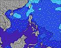 | 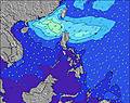 | 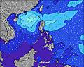 | 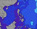 | 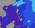 | 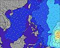 | 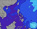 | |||||||||||||
Wave Height (m) Direction Period (s) | ESE 10 | ENE 5 | E 6 | E 6 | E 6 | E 6 | E 9 | ESE 9 | E 8 | E 10 | E 9 | E 16 | E 18 | E 16 | E 15 | E 18 | E 16 | E 16 | E 18 | E 18 |
Wave Graph | ||||||||||||||||||||
10 | 37 | 31 | 17 | 11 | 17 | 7 | 8 | 6 | 8 | 6 | 21 | 24 | 81 | 153 | 155 | 422 | 590 | 509 | 1063 | |
Wind (km/h) | ||||||||||||||||||||
Wind State on-shore cross-onshore cross-shore cross-offshore off-shore glassy | glassy | glassy | cross-on | glassy | glassy | cross-on | glassy | glassy | cross-on | glassy | cross-off | cross-on | glassy | glassy | cross | glassy | cross-off | cross | glassy | cross-off |
High Tide | 6:18PM1.54m | 5:50AM1.75m | 6:46PM1.59m | 6:25AM1.78m | 7:14PM1.64m | 7:00AM1.77m | 7:41PM1.67m | 7:35AM1.73m | 8:10PM1.68m | 8:13AM1.66m | 8:40PM1.68m | 8:55AM1.56m | 9:14PM1.65m | |||||||
Low Tide | 11:51PM0.62m | 12:23PM0.15m | 00:24AM0.55m | 12:53PM0.16m | 00:58AM0.50m | 1:22PM0.19m | 1:32AM0.47m | 1:52PM0.26m | 2:09AM0.44m | 2:23PM0.36m | 2:49AM0.44m | 2:57PM0.47m | 3:37AM0.45m | |||||||
— | — | 5:33 | — | — | 5:33 | — | — | 5:33 | — | — | 5:35 | — | — | 5:35 | — | — | 5:35 | — | — | |
6:25 | — | — | 6:24 | — | — | 6:24 | — | — | 6:24 | — | — | 6:23 | — | — | 6:23 | — | — | 6:22 | — | |
mm | 4 | 4 | 2 | 1 | 2 | — | — | — | — | 5 | 10 | — | 3 | 4 | — | 1 | 3 | — | 5 | 5 |
Temp °C | 27 | 26 | 28 | 30 | 26 | 30 | 31 | 27 | 31 | 30 | 26 | 31 | 30 | 26 | 31 | 31 | 27 | 31 | 31 | 26 |
Feels °C | 33 | 31 | 33 | 34 | 32 | 34 | 35 | 33 | 34 | 35 | 32 | 35 | 35 | 31 | 35 | 35 | 33 | 34 | 36 | 31 |
Swell 1 Height (m) Direction Period (s) | ESE 10 | E 5 | E 6 | E 6 | E 6 | E 6 | E 6 | E 6 | E 6 | E 6 | E 9 | E 9 | E 9 | E 16 | E 15 | E 14 | E 16 | E 16 | E 14 | E 18 |
10 | 13 | 16 | 17 | 11 | 11 | 7 | 3 | 3 | 2 | 6 | 6 | 14 | 81 | 153 | 103 | 422 | 590 | 338 | 1063 | |
Swell 2 Height (m) Direction Period (s) | E 4 | ESE 10 | ESE 10 | ESE 10 | E 9 | E 9 | E 9 | ESE 9 | E 8 | E 10 | E 5 | E 16 | E 18 | E 9 | E 9 | E 18 | ENE 8 | E 10 | E 18 | E 10 |
1 | 9 | 9 | 9 | 6 | 6 | 6 | 8 | 6 | 8 | 2 | 21 | 24 | 14 | 14 | 155 | 14 | 2 | 509 | 2 | |
Swell 3 Height (m) Direction Period (s) | E 10 | E 9 | E 9 | E 9 | ESE 10 | SE 10 | SE 10 | E 8 | SE 9 | SE 9 | SE 9 | E 5 | SE 9 | E 12 | SE 9 | E 9 | E 8 | ENE 8 | E 10 | — |
7 | 7 | 6 | 6 | 9 | 4 | 4 | 5 | 3 | 3 | 3 | 1 | 3 | 3 | 3 | 13 | 1 | 22 | 2 | — | |
Wind waves Height (m) Direction Period (s) | ENE 4 | ENE 5 | E 6 | — | — | E 6 | — | — | — | — | — | — | — | — | — | — | — | — | — | — |
6 | 37 | 31 | — | — | 17 | — | — | — | — | — | — | — | — | — | — | — | — | — | — | |
Nearest Offshore or Glassy | ||||||||||||||||||||
Distance (km) | 1981 | 0 | 254 | 254 | 201 | 1413 | 675 | 991 | 1541 | 1266 | 201 | 19 | 0 | 0 | 19 | 0 | 0 | 18 | 0 | 0 |
Best forecast wave conditions in West Luzon | ||||||||||||||||||||
Best forecast wave conditions in Philippines | ||||||||||||||||||||
Header Global | ||||||||||||||||||||
- Map Icons:
 Break
Break Live Wave Height (m)
 Live Wind Speed (km/h)
 Surf Rating (10 Max)
 Ocean Swells (m)
- Wind Speed (km/h)


FREE! Surf-Forecast.com widget for your website
The surf report / weather widget below is available to embed on third party websites free of charge and provides a summary of our Malaking Gasang (Baler) surf forecast. Simply grab the html code snippet that we provide and paste it into your own site. You can choose your preferred language and metric/imperial units for the surf forecast feed to suit users of your site. Click here to get the code.
Information about the Malaking Gasang (Baler) Surf forecast
The above surf forecast table for Malaking Gasang (Baler) provides essential information for determining whether the surfing conditions will be good over the next 16 days. A general guide to surfing at Malaking Gasang (Baler) can be found by selecting the local surf guide option on the grey menu. Our Malaking Gasang (Baler) surf forecast is unique since it includes wave energy (power) that defines the real feel of the surf rather than just the height or the period. If you surf the same spot (Malaking Gasang (Baler)) regularly then make a mental note of the wave energy from the surf forecast table each time you go. Very soon you may start to choose your surf days based on the wave energy alone combined with our forecast of favourable offshore wind conditions. Our star ratings will help here and of course you will also find the usual wave height and period predictions on our surf forecasts as well as a full break down of the swell components under our advanced users option (to reveal that, click the little Einstein character under the tide times).
Further information to help with frequently asked questions about our surf forecast for Malaking Gasang (Baler) may be found under the help tab on the top menu and also by moving your mouse over the question marks on the surf forecast table itself. Please always bear in mind that the forecast is for near-shore open water and local factors at each surf break influence the actual breaking wave height, such as the beach / reef profile, water depths offshore and shelter.
 Nearest