

Surf Forecasts:

Anna Maria Island surf forecast from 3 Aug 2026:
- Most powerful swell: Monday 3 Aug, 8AM (local time) - 2.5ft (0.7m), 6s period, WSW swell with 37 kJ wave energy.
Best Forecast Surf Conditions for Anna Maria Island this week:
The most powerful waves expected at Anna Maria Island in the next 16 days are 0.7m 6s and forecast to arrive on Monday (Aug 03) at 8AM. Winds are predicted to be cross-offshore at the time the swell arrives. The largest open ocean swell (not directed at the beach) is 0.6m 3s period and expected on Friday (Aug 07) at 2AM.
| Wave Type | Time (EDT) & Date | Wave Height & Period |
|---|---|---|
| Next good surf (1 star+) | - | - |
| Best Surf | - | - |
| Most Powerful | 8AM (Mon 3rd Aug) | 2.5ft (0.7m) 6s |
Table - best surf conditions forecast for Anna Maria Island over the next 16 days.
The Lowdown
Hey folks, Rusty here. Let's talk about Anna Maria Island. I've gotta be straight with you – the next couple of weeks are looking pretty grim for a paddle. The water is sitting at a warm 87°, which is about 1° above normal for this time of year, so it's feeling like a warm bath out there.
The whole 16-day window is basically a write-off for decent surf. We're looking at a long stretch of tiny, weak waves, if any at all. The combined energy of the swells is barely registering, often hitting single-digit numbers. For the first week, from Monday, August 3rd through to Sunday, August 9th, we're stuck with ankle-snappers. Monday morning kicks off with a weak 2ft swell from the WSW, but it's bumpy with a 12 mph cross-shore wind and a short 6-second period, making for a total mess. The energy is a paltry 24. Tuesday through Sunday is even worse, with waves dropping to 1ft or 0.7ft, and most readings showing zero energy. There are a few cleaner moments here and there, like Tuesday afternoon with a gentle cross-offshore breeze, but the swell is just too small to do anything with.
The second week doesn't get any better. From Monday, August 10th through to Tuesday, August 18th, it's the same story. We see a few patches of glassy or offshore wind, like on Wednesday morning, August 12th, when it's completely flat and glassy, or Tuesday morning, August 18th, with a light offshore and a clean 1ft wave. That 1ft on the 18th has the highest energy we'll see in the whole period, sitting at 10, but that's still weak. It's a WNW swell with a 4-second period, so it's just not going to have any push.
With the swell being so small and the breaks here being inconsistent, the best I can say is that if you're an absolute beginner, the very cleanest, flattest days might be okay for sitting on a foamie, but you won't be riding anything. For anyone else, this is a kiteboarding window if the wind picks up properly. For surfers, it's a blank run. Don't get too down though – it tends not to stay this poor for long, and forecasts can change. Until then, keep the board in the car, but don't hold your breath.
Rusty.
Short Range ForecastLight rain (total 8mm), mostly falling on Mon morning. Warm (max 30°C on Wed afternoon, min 26°C on Wed morning). Wind will be generally light. | Days 4-6 Weather SummaryHeavy rain (total 37mm), heaviest during Thu night. Warm (max 33°C on Fri afternoon, min 26°C on Thu morning). Wind will be generally light. | ||||||||||||||||||||
Monday 3 | Tuesday 4 | Wednesday 5 | Thursday 6 | Friday 7 | Saturday 8 | Sunday 9 | |||||||||||||||
AM | PM | Night | AM | PM | Night | AM | PM | Night | AM | PM | Night | AM | PM | Night | AM | PM | Night | AM | PM | Night | |
Swell Height Map |  |  |  | 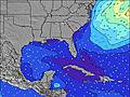 | 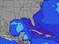 | 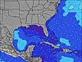 | 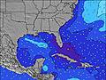 | ||||||||||||||
Wave Height (m) Direction Period (s) | WSW 6 | WSW 6 | W 6 | W 5 | W 5 | W 5 | W 5 | W 5 | — | SE 3 | S 4 | S 6 | ESE 3 | S 6 | E 3 | SE 3 | S 5 | SE 3 | SSE 3 | S 5 | S 4 |
Wave Graph | |||||||||||||||||||||
24 | 26 | 17 | 9 | 5 | 4 | 2 | 2 | 0 | 0 | 2 | 1 | 0 | 1 | 0 | 0 | 2 | 0 | 0 | 2 | 2 | |
Wind (km/h) | |||||||||||||||||||||
Wind State on-shore cross-onshore cross-shore cross-offshore off-shore glassy | cross | cross-on | cross-off | cross-on | cross-off | off | cross-off | cross-on | cross-off | cross-off | on | cross-off | cross-off | cross-off | cross-off | cross-off | on | off | off | cross-on | off |
High Tide | 3:53PM0.60m | 4:02AM0.68m | 5:03PM0.52m | 4:34AM0.73m | 6:33PM0.45m | 5:13AM0.77m | 6:05AM0.80m | 7:15AM0.83m | 8:33AM0.85m | ||||||||||||
Low Tide | 9:42AM0.21m | 9:40PM0.24m | 10:46AM0.16m | 9:59PM0.31m | 12:02PM0.12m | 10:07PM0.38m | 1:27PM0.07m | 2:54PM0.01m | 4:12PM-0.05m | 5:13PM-0.09m | |||||||||||
6:54 | — | — | 6:54 | — | — | 6:56 | — | — | 6:56 | — | — | 6:56 | — | — | 6:56 | — | — | 6:58 | — | — | |
— | 8:17 | — | — | 8:17 | — | — | 8:16 | — | — | 8:15 | — | — | 8:15 | — | — | 8:15 | — | — | 8:14 | — | |
mm | 3 | 1 | 1 | 1 | — | — | — | — | 2 | — | 2 | 17 | 4 | 5 | 3 | — | 1 | 5 | — | — | — |
Temp °C | 29 | 29 | 28 | 29 | 29 | 29 | 27 | 30 | 29 | 28 | 31 | 30 | 29 | 33 | 31 | 28 | 30 | 28 | 28 | 30 | 30 |
Feels °C | 30 | 30 | 30 | 31 | 30 | 32 | 29 | 32 | 31 | 30 | 34 | 33 | 30 | 36 | 33 | 31 | 33 | 31 | 31 | 34 | 33 |
Swell 1 Height (m) Direction Period (s) | — | — | W 6 | — | W 5 | W 5 | W 5 | W 5 | — | — | S 4 | — | — | — | — | — | S 5 | — | — | S 5 | S 4 |
— | — | 17 | — | 5 | 4 | 2 | 2 | — | — | 2 | — | — | — | — | — | 2 | — | — | 2 | 2 | |
Swell 2 Height (m) Direction Period (s) | — | — | S 4 | — | — | — | — | — | — | — | — | S 6 | — | S 6 | — | — | — | — | — | — | — |
— | — | 1 | — | — | — | — | — | — | — | — | 1 | — | 1 | — | — | — | — | — | — | — | |
Swell 3 Height (m) Direction Period (s) | — | — | — | — | — | — | — | — | — | — | — | — | — | — | — | — | — | — | — | — | — |
— | — | — | — | — | — | — | — | — | — | — | — | — | — | — | — | — | — | — | — | — | |
Wind waves Height (m) Direction Period (s) | WSW 6 | WSW 6 | — | W 5 | — | — | — | — | — | SE 3 | — | E 3 | ESE 3 | — | E 3 | SE 3 | — | SE 3 | SSE 3 | — | — |
24 | 26 | — | 9 | — | — | — | — | — | 2 | — | 8 | 3 | — | 5 | 3 | — | 6 | 4 | — | — | |
Nearest Offshore or Glassy | |||||||||||||||||||||
Distance (km) | 283 | 248 | 1151 | 227 | 244 | 227 | 283 | 251 | 1491 | 297 | 1693 | 1471 | 1147 | 636 | 842 | 732 | 732 | 242 | 244 | 1432 | 244 |
Best forecast wave conditions in Gulf Coast, Florida | |||||||||||||||||||||
Best forecast wave conditions in United States | |||||||||||||||||||||
Header Global | |||||||||||||||||||||
- Map Icons:
 Break
Break Live Wave Height (m)
 Live Wind Speed (km/h)
 Surf Rating (10 Max)
 Ocean Swells (m)
- Wind Speed (km/h)
Latest Updates


FREE! Surf-Forecast.com widget for your website
The surf report / weather widget below is available to embed on third party websites free of charge and provides a summary of our Anna Maria Island surf forecast. Simply grab the html code snippet that we provide and paste it into your own site. You can choose your preferred language and metric/imperial units for the surf forecast feed to suit users of your site. Click here to get the code.
Information about the Anna Maria Island Surf forecast
The above surf forecast table for Anna Maria Island provides essential information for determining whether the surfing conditions will be good over the next 16 days. A general guide to surfing at Anna Maria Island can be found by selecting the local surf guide option on the grey menu. Our Anna Maria Island surf forecast is unique since it includes wave energy (power) that defines the real feel of the surf rather than just the height or the period. If you surf the same spot (Anna Maria Island) regularly then make a mental note of the wave energy from the surf forecast table each time you go. Very soon you may start to choose your surf days based on the wave energy alone combined with our forecast of favourable offshore wind conditions. Our star ratings will help here and of course you will also find the usual wave height and period predictions on our surf forecasts as well as a full break down of the swell components under our advanced users option (to reveal that, click the little Einstein character under the tide times).
Further information to help with frequently asked questions about our surf forecast for Anna Maria Island may be found under the help tab on the top menu and also by moving your mouse over the question marks on the surf forecast table itself. Please always bear in mind that the forecast is for near-shore open water and local factors at each surf break influence the actual breaking wave height, such as the beach / reef profile, water depths offshore and shelter.
Anna Maria Island is 17 km (11 miles) from Bradenton. If you plan a vacation in Gulf Coast, Florida, look for hotels and other accommodation in Bradenton. Bradenton has rooms for a wide range of budgets as well as car hire and transport links.
 Nearest