

Anna Maria Island Surf Guide
Anna Maria Island in Gulf Coast, Florida is an exposed beach break that has inconsistent surf. Winter is the best time of year for surfing here. The best wind direction is from the southeast. Usually gets local windswells, but groundswells do happen and the best wave direction is from the west southwest. The beach breaks favour lefts. It's sometimes crowded here. Watch out for - Rips / undertow - Localism.
Anna Maria Island Spot Info
| Type: | Rating: | Reliability: | Todays Sea Temp*: |
|---|---|---|---|
| inconsistent | 30.0°C*ocean temperature recorded from satellite |
Surfing Anna Maria Island:
The best conditions reported for surf at Anna Maria Island occur when a West-southwest swell combines with an offshore wind direction from the Southeast.
What's the best time of year to surf Anna Maria Island (for consistent clean waves)?
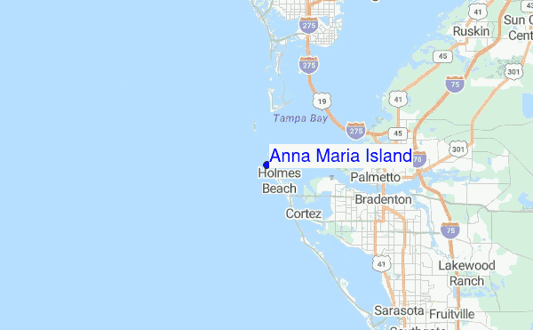
Explore Anna Maria Island Location Map
Interactive Anna Maria Island surf break location map. View information about nearby surf breaks, their wave consistency and rating compared to other spots in the region. Current swell conditions from local buoys are shown along with live wind speed and direction from nearby weather stations. Click icons on the map for more detail. The closest passenger airport to Anna Maria Island is Albert Whitted (St. Petersburg) Airport (SPG) in USA, 28 km (17 miles) away (directly). The second nearest airport to Anna Maria Island is Macdill Afb (Tampa) Airport (MCF), also in USA, 41 km (25 miles) away.
- Map Icons:
 Break
Break Live Wave Height (m)
 Live Wind Speed (km/h)
 Surf Rating (10 Max)
 Ocean Swells (m)
- Wind Speed (km/h)
Sunday, 21 June 2026, 10:07 Local Time
| Sunday 21 | ||||
| 11AM | 2PM | 5PM | 8PM | |
| Wave (m) | ||||
| Period (s) | 5 | 5 | 5 | 5 |
| Wind (km/h) | ||||
| Wind State | cross- on |
cross- on |
cross- on |
cross- on |
Tides at Anna Maria Island
| NEXT | IS AT (local time) | remaining |
|---|---|---|
| high tide | ||
| low tide |
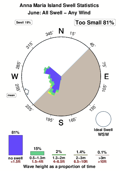
Swell History at Anna Maria Island
Surf stats for Anna Maria Island, see the swell variation by month or season on the history page here.

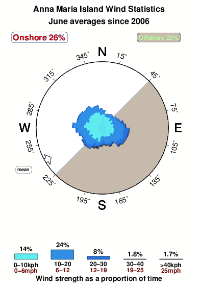
Wind History at Anna Maria Island
Wind stats for Anna Maria Island, see the variation in direction and stength by month or season on the history page here.
Anna Maria Island Reviews:
Interactive Porthcawl Point location map. View nearby buoy information, live wind conditions and surrounding roads, paths and locations to help find new breaks. Click the buoys or wind icon to view more information.
- Overall:
 2.0
2.0 - Quality on a good day:2.3
- Consistency of Surf:
 2.7
2.7 - Difficulty Level:1.8
- Wind and Kite Surfing:
 4.0
4.0 - Crowds:3.3
I would like if website would display in increments of less than .5 feet.
More importantly is the accuracy. Drove out here today, the surf is pretty high, perhaps well over 1 ft, the beach flag is yellow, yet the website is showing blank, which I have interpreted as zero. Truly disappointed.
Thank you
[Editor replies. Angelina, this site is really designed only for surfers and so we do not report things that are of no interest to them like very small waves that are close together. To view everything our model predicts about the sea state, including the small details of more interest to swimmers, look here instead: tide-forecast.com and look for Anna-Maria-Key-Bradenton-Beach-Tampa-Bay-Florida. I think that forecast was about right for Friday]”
Other Nearby Breaks Closest To:
Discover surf breaks near Anna Maria Island. Click below to view there surf guides.
 Nearest