

Surf Forecasts:

How big are the waves at S-Turns today (03 Aug):
- Morning surf: Morning surf (03 Aug, local time) - 7ft (2.2m), 7s period with S swell.
- Afternoon surf: Afternoon surf (03 Aug, local time) - 6ft (1.9m), 7s period with S swell.
- Evening surf: Evening surf (03 Aug, local time) - 5.5ft (1.7m), 7s period with S swell.
The current surf forecast for S-Turns at 5AM is: 2.2m 8s primary swell from a South direction and 0.1m 13s secondary swell from a East direction (forecast issued at 01:00am August 03). The wind direction is predicted to be cross-offshore.
| Time (EDT) & Date | Wave Height | Wave Period |
|---|---|---|
| Morning (03 Aug) | 7ft (2.2m) | 7s |
| Afternoon (03 Aug) | 6ft (1.9m) | 7s |
| Evening (03 Aug) | 5.5ft (1.7m) | 7s |
Table - waves today at S-Turns. (Swell directed towards the surf break)
Short Range ForecastHeavy rain (total 91mm), heaviest during Mon afternoon. Warm (max 28°C on Wed afternoon, min 24°C on Mon morning). Winds decreasing (strong winds from the SSW on Tue afternoon, light winds from the SSW by Wed morning). | ||||||||||||||||||||||||
Monday 3 | Tuesday 4 | Wednesday 5 | ||||||||||||||||||||||
2 AM | 5 AM | 8 AM | 11 AM | 2 PM | 5 PM | 8 PM | 11 PM | 2 AM | 5 AM | 8 AM | 11 AM | 2 PM | 5 PM | 8 PM | 11 PM | 2 AM | 5 AM | 8 AM | 11 AM | 2 PM | 5 PM | 8 PM | 11 PM | |
Swell Height Map | 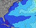 | 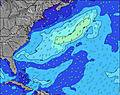 | 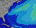 | 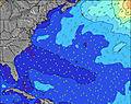 | 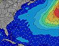 | 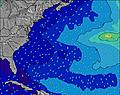 | 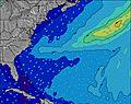 | 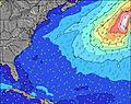 | 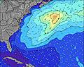 | |||||||||||||||
Wave Height (m) Direction Period (s) | SSE 8 | S 8 | S 7 | S 7 | S 7 | S 7 | S 7 | S 7 | S 8 | SSW 8 | S 7 | S 7 | S 7 | S 6 | S 6 | S 6 | S 6 | SE 7 | SE 7 | SE 7 | SE 6 | SE 7 | S 6 | S 6 |
Wave Graph | ||||||||||||||||||||||||
607 | 551 | 578 | 483 | 397 | 371 | 295 | 271 | 566 | 534 | 246 | 159 | 113 | 139 | 157 | 109 | 91 | 60 | 55 | 44 | 51 | 47 | 39 | 50 | |
Wind (km/h) | ||||||||||||||||||||||||
Wind State on-shore cross-onshore cross-shore cross-offshore off-shore glassy | cross-off | cross-off | cross-off | cross-off | cross-off | cross-off | cross-off | cross-off | cross-off | cross-off | cross-off | cross | cross-off | cross-off | cross-off | cross-off | cross-off | cross-off | cross-off | cross-off | cross-off | cross-off | cross-off | cross-off |
High Tide | 1:37AM0.25m | 2:28PM0.21m | 2:09AM0.25m | 3:22PM0.22m | 2:46AM0.25m | 4:18PM0.22m | ||||||||||||||||||
Low Tide | 9:12AM0.11m | 8:01PM0.13m | 9:10AM0.10m | 8:38PM0.14m | 9:36AM0.09m | 9:23PM0.14m | ||||||||||||||||||
— | 6:11 | — | — | — | — | — | — | — | 6:11 | — | — | — | — | — | — | — | 6:11 | — | — | — | — | — | — | |
— | — | — | — | — | — | 8:04 | — | — | — | — | — | — | — | 8:02 | — | — | — | — | — | — | — | 8:01 | — | |
mm | 1 | 1 | 4 | 10 | 18 | 4 | 2 | 1 | 4 | 5 | 5 | 3 | 6 | 13 | 2 | 1 | 2 | 2 | 3 | 1 | 1 | — | — | 1 |
Temp °C | 28 | 28 | 25 | 24 | 25 | 25 | 26 | 26 | 26 | 25 | 25 | 25 | 24 | 25 | 25 | 26 | 26 | 27 | 27 | 27 | 27 | 28 | 27 | 27 |
Feels °C | 25 | 25 | 22 | 23 | 24 | 24 | 26 | 26 | 27 | 26 | 25 | 25 | 22 | 22 | 23 | 25 | 25 | 27 | 28 | 29 | 28 | 29 | 28 | 28 |
Swell 1 Height (m) Direction Period (s) | E 14 | E 13 | E 13 | E 13 | E 13 | E 13 | E 13 | SSE 7 | S 8 | S 8 | E 14 | ESE 8 | SE 7 | ESE 7 | SE 7 | ESE 7 | SE 7 | SE 7 | SE 7 | SE 7 | SE 6 | SE 7 | SE 7 | ESE 7 |
4 | 4 | 4 | 4 | 3 | 3 | 3 | 232 | 358 | 396 | 4 | 37 | 51 | 30 | 25 | 36 | 38 | 55 | 55 | 44 | 51 | 47 | 37 | 32 | |
Swell 2 Height (m) Direction Period (s) | — | — | — | — | — | — | — | E 13 | E 13 | E 13 | — | E 14 | — | E 12 | E 12 | E 12 | N 6 | NNE 5 | NNE 5 | NNE 5 | NNE 5 | NNE 5 | NNE 5 | NE 5 |
— | — | — | — | — | — | — | 3 | 4 | 3 | — | 4 | — | 3 | 3 | 3 | 1 | 3 | 3 | 3 | 3 | 2 | 2 | 1 | |
Swell 3 Height (m) Direction Period (s) | — | — | — | — | — | — | — | — | — | E 9 | E 9 | E 12 | — | E 8 | — | E 12 | E 12 | E 12 | E 12 | E 9 | E 12 | E 9 | E 9 | E 11 |
— | — | — | — | — | — | — | — | — | 2 | 2 | 3 | — | 1 | — | 3 | 3 | 3 | 3 | 2 | 3 | 2 | 2 | 2 | |
Wind waves Height (m) Direction Period (s) | SSE 8 | S 8 | S 7 | S 7 | S 7 | S 7 | S 7 | S 7 | S 8 | SSW 8 | S 7 | S 7 | S 7 | S 6 | S 6 | S 6 | S 6 | S 6 | S 6 | S 6 | S 6 | S 6 | S 6 | S 6 |
607 | 551 | 578 | 483 | 397 | 371 | 295 | 271 | 566 | 534 | 246 | 159 | 113 | 139 | 157 | 109 | 91 | 60 | 46 | 32 | 31 | 41 | 39 | 50 | |
Nearest Offshore or Glassy | ||||||||||||||||||||||||
Distance (km) | 637 | 808 | 637 | 327 | 327 | 327 | 301 | 61 | 38 | 19 | 52 | 92 | 284 | 138 | 137 | 154 | 137 | 137 | 137 | 321 | 61 | 152 | 152 | 397 |
Best forecast wave conditions in North Carolina | ||||||||||||||||||||||||
Best forecast wave conditions in United States | ||||||||||||||||||||||||
Header Global | ||||||||||||||||||||||||
- Map Icons:
 Break
Break Live Wave Height (m)
 Live Wind Speed (km/h)
 Surf Rating (10 Max)
 Ocean Swells (m)
- Wind Speed (km/h)
Latest Updates


FREE! Surf-Forecast.com widget for your website
The surf report / weather widget below is available to embed on third party websites free of charge and provides a summary of our S-Turns surf forecast. Simply grab the html code snippet that we provide and paste it into your own site. You can choose your preferred language and metric/imperial units for the surf forecast feed to suit users of your site. Click here to get the code.
 Nearest