

Surf Forecasts:

Playa del Hombre surf forecast from 11 Jul 2026:
- Most powerful swell: Saturday 18 Jul, 10AM (local time) - 6.5ft (2.0m), 8s period, NNE swell with 541 kJ wave energy.
Best Forecast Surf Conditions for Playa del Hombre this week:
The most powerful waves expected at Playa del Hombre in the next 16 days are 2.0m 8s and forecast to arrive on Saturday (Jul 18) at 10AM. Winds are predicted to be cross-shore at the time the swell arrives. The largest open ocean swell (not directed at the beach) is 0.3m 19s period and expected on Saturday (Jul 11) at 1PM.
| Wave Type | Time (WEST) & Date | Wave Height & Period |
|---|---|---|
| Next good surf (1 star+) | - | - |
| Best Surf | - | - |
| Most Powerful | 10AM (Sat 18th Jul) | 6.5ft (2.0m) 8s |
Table - best surf conditions forecast for Playa del Hombre over the next 16 days.
Alright folks, Rusty here. Let’s talk about what’s coming up for Playa del Hombre over the next couple of weeks.
Right off the bat, I’m not gonna sugarcoat it – the first week is a tough one. The boys in the water are gonna be quiet. We’ve got a nasty run of poor surf conditions from the start. The wind is mostly cross or cross-onshore, and it’s blowing a moderate to fresh breeze most days, which is just chopping everything up. The swell is there, but it’s not doing us any favours with the wind state.
The first real hint of something happening doesn’t come until the 16th of July, Thursday. The swell bumps up to 5 ft from the NNE, but the period is short at 6-7 seconds, and the wind is still a fresh cross-shore. The wave energy is moderate (204-263), but the conditions are labelled as poor, so it’s not worth getting excited about.
Things actually get a bit bigger as we head into the 18th and 19th of July. Swell pushes 7 ft to 7 ft from the NNE, with a period of 8 seconds. The energy is starting to get strong (541-606), but the wind is still a fresh cross-shore, creating lumpy, cross-chop conditions. It’s still rated as poor surf.
Now, the standout moment comes much later. On the 25th of July (Saturday), we finally see some potential. The swell ramps up to 10 ft from the NNE in the morning, with a period of 9 seconds. The combined wave energy is very strong (1232). That’s a lot of water moving. The wind is cross-onshore in the morning, which is still a bit messy, but by the afternoon it shifts to a cross-shore, and the wave comment upgrades to "marginal". The swell drops to 8 ft, but it’s the closest we get to a proper window. That’s the pick of the bunch, but it’s only for the experienced crew – 8 ft+ is expert territory, especially with the wind being tricky. The water temp is sitting at 71°F which is about average for this time of year.
The rest of the window, right through to the 26th of July, is a write-off with the same story: solid swell (7 ft to 8 ft) but a persistent onshore or cross-shore breeze that’s keeping the surface chopped and bumpy. The wave energy is strong (900-1200 range), but it’s not translating into clean surf.
So, to be honest, there’s no real need to rush down there for the first ten days. If you’re desperate for a paddle, the 25th of July is the only date that might offer something for the experts, but don’t expect perfection. The rest of the time, the setup is more interesting for a kite surfer than a paddle surfer.
Rusty.
Short Range ForecastMostly dry. Warm (max 24°C on Sat morning, min 19°C on Sun night). Wind will be generally light. | Days 4-6 Weather SummaryMostly dry. Warm (max 23°C on Tue afternoon, min 20°C on Tue night). Mainly fresh winds. | ||||||||||||||||||||
Saturday 11 | Sunday 12 | Monday 13 | Tuesday 14 | Wednesday 15 | Thursday 16 | Friday 17 | |||||||||||||||
AM | PM | Night | AM | PM | Night | AM | PM | Night | AM | PM | Night | AM | PM | Night | AM | PM | Night | AM | PM | Night | |
Swell Height Map |  |  | 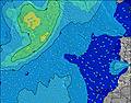 | 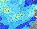 | 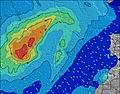 | 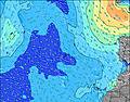 | 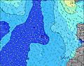 | ||||||||||||||
Wave Height (m) Direction Period (s) | N 5 | N 5 | N 5 | NNW 8 | NNW 10 | NNW 9 | NNW 10 | NNW 9 | NNW 9 | NNW 8 | NNW 8 | NE 5 | NE 5 | NNE 5 | NNE 6 | NNE 6 | NNE 7 | NNE 7 | NNE 8 | NNE 8 | NNE 8 |
Wave Graph | |||||||||||||||||||||
19 | 13 | 29 | 118 | 157 | 153 | 150 | 113 | 67 | 54 | 54 | 34 | 31 | 61 | 119 | 167 | 263 | 353 | 428 | 456 | 527 | |
Wind (km/h) | |||||||||||||||||||||
Wind State on-shore cross-onshore cross-shore cross-offshore off-shore glassy | cross | cross | cross | cross-on | cross-on | cross-on | cross-on | cross-on | cross-on | cross-on | cross-on | cross-on | cross-on | cross-on | cross | cross | cross | cross | cross | cross | cross |
High Tide | 11:28AM1.86m | 00:00AM1.86m | 12:28PM2.01m | 1:00AM1.96m | 1:22PM2.16m | 1:53AM2.04m | 2:11PM2.28m | 2:42AM2.08m | 2:58PM2.36m | 3:29AM2.08m | 3:44PM2.37m | 4:14AM2.03m | 4:28PM2.31m | ||||||||
Low Tide | 5:45PM0.38m | 6:09AM0.33m | 6:46PM0.22m | 7:04AM0.23m | 7:40PM0.08m | 7:54AM0.15m | 8:31PM-0.01m | 8:40AM0.11m | 9:18PM-0.04m | 9:25AM0.11m | 10:04PM-0.01m | 10:08AM0.16m | 10:48PM0.08m | ||||||||
7:11 | — | — | 7:13 | — | — | 7:13 | — | — | 7:13 | — | — | 7:13 | — | — | 7:15 | — | — | 7:15 | — | — | |
— | — | 9:00 | — | — | 9:00 | — | — | 9:00 | — | — | 9:00 | — | 8:59 | — | — | 8:59 | — | — | 8:59 | — | |
mm | — | — | — | — | — | — | — | — | — | — | — | — | — | — | — | — | — | — | — | — | — |
Temp °C | 24 | 23 | 22 | 23 | 23 | 21 | 22 | 23 | 21 | 22 | 23 | 21 | 23 | 23 | 21 | 23 | 23 | 21 | 23 | 24 | 21 |
Feels °C | 25 | 23 | 21 | 22 | 21 | 20 | 20 | 22 | 20 | 21 | 22 | 21 | 22 | 21 | 19 | 21 | 21 | 19 | 21 | 22 | 18 |
Swell 1 Height (m) Direction Period (s) | N 5 | N 5 | SSW 14 | NNW 8 | NNW 10 | NNW 9 | NNW 10 | NNW 9 | NNW 9 | NNW 8 | NNW 8 | N 8 | NNW 8 | SSW 13 | NW 8 | NE 7 | NW 9 | SW 13 | S 12 | SW 19 | SW 19 |
19 | 13 | 18 | 118 | 157 | 153 | 150 | 113 | 67 | 54 | 54 | 34 | 21 | 16 | 2 | 37 | 3 | 7 | 3 | 15 | 14 | |
Swell 2 Height (m) Direction Period (s) | SSW 19 | SSW 14 | SSW 18 | SSW 18 | SSW 13 | SSW 16 | SSW 16 | SSW 15 | SSW 15 | SSW 14 | SSW 13 | SSW 13 | SW 13 | NW 8 | S 12 | SW 15 | SW 14 | NW 8 | S 20 | SW 12 | S 11 |
37 | 19 | 31 | 61 | 17 | 51 | 50 | 43 | 21 | 20 | 17 | 17 | 7 | 3 | 3 | 8 | 8 | 3 | 8 | 6 | 2 | |
Swell 3 Height (m) Direction Period (s) | SSW 14 | SSW 19 | NNW 10 | SSW 13 | SSW 17 | SSW 13 | SSW 12 | SSW 12 | SSW 12 | SSW 12 | SW 11 | SW 11 | SW 11 | S 16 | S 15 | NW 7 | — | S 21 | S 20 | NW 8 | — |
20 | 37 | 9 | 18 | 29 | 16 | 15 | 14 | 13 | 14 | 5 | 4 | 5 | 5 | 4 | 2 | — | 9 | 8 | 3 | — | |
Wind waves Height (m) Direction Period (s) | — | NW 5 | N 5 | — | N 10 | NNE 4 | NNE 3 | ENE 4 | NNE 4 | NE 4 | NE 4 | NE 5 | NE 5 | NNE 5 | NNE 6 | NNE 6 | NNE 7 | NNE 7 | NNE 8 | NNE 8 | NNE 8 |
— | 3 | 29 | — | 121 | 13 | 6 | 1 | 5 | 4 | 6 | 31 | 31 | 61 | 119 | 167 | 263 | 353 | 428 | 456 | 527 | |
Nearest Offshore or Glassy | |||||||||||||||||||||
Distance (km) | 34 | 34 | 36 | 36 | 36 | 19 | 19 | 19 | 19 | 19 | 40 | 126 | 40 | 134 | 134 | 546 | 147 | 40 | 95 | 132 | 132 |
Best forecast wave conditions in Gran Canaria | |||||||||||||||||||||
Best forecast wave conditions in Spain (Africa) | |||||||||||||||||||||
Header Global | |||||||||||||||||||||
- Map Icons:
 Break
Break Live Wave Height (m)
 Live Wind Speed (km/h)
 Surf Rating (10 Max)
 Ocean Swells (m)
- Wind Speed (km/h)


FREE! Surf-Forecast.com widget for your website
The surf report / weather widget below is available to embed on third party websites free of charge and provides a summary of our Playa del Hombre surf forecast. Simply grab the html code snippet that we provide and paste it into your own site. You can choose your preferred language and metric/imperial units for the surf forecast feed to suit users of your site. Click here to get the code.
Information about the Playa del Hombre Surf forecast
The above surf forecast table for Playa del Hombre provides essential information for determining whether the surfing conditions will be good over the next 16 days. A general guide to surfing at Playa del Hombre can be found by selecting the local surf guide option on the grey menu. Our Playa del Hombre surf forecast is unique since it includes wave energy (power) that defines the real feel of the surf rather than just the height or the period. If you surf the same spot (Playa del Hombre) regularly then make a mental note of the wave energy from the surf forecast table each time you go. Very soon you may start to choose your surf days based on the wave energy alone combined with our forecast of favourable offshore wind conditions. Our star ratings will help here and of course you will also find the usual wave height and period predictions on our surf forecasts as well as a full break down of the swell components under our advanced users option (to reveal that, click the little Einstein character under the tide times).
Further information to help with frequently asked questions about our surf forecast for Playa del Hombre may be found under the help tab on the top menu and also by moving your mouse over the question marks on the surf forecast table itself. Please always bear in mind that the forecast is for near-shore open water and local factors at each surf break influence the actual breaking wave height, such as the beach / reef profile, water depths offshore and shelter.
 Nearest