

Surf Forecasts:

La Santa - The Slab surf forecast from 22 Jul 2026:
- Best quality surf: Sunday 26 Jul, 4AM (local time) - 10ft (3.0m), 8s period, NNE swell with cross-offshore winds.
- Most powerful swell: Sunday 26 Jul, 10AM (local time) - 10ft (3.0m), 8s period, NNE swell with 1,134 kJ wave energy.
- Next surfable swell (1★+): Sunday 26 Jul, 4AM (local time) - 10ft (3.0m), 8s period with NNE swell.
Best Forecast Surf Conditions for La Santa - The Slab this week:
The surf forecast for La Santa - The Slab over the next 16 days: The first swell (rated 1 star or higher) is forecast to arrive on Sunday (Jul 26) at 4AM. The primary swell is predicted to be 3.0m and 8s period with a secondary swell of 0.1m and 10s. The wind is predicted to be cross-offshore as the swell arrives.
The most powerful waves expected at La Santa - The Slab in the next 16 days are 3.0m 8s and forecast to arrive on Sunday (Jul 26) at 10AM. Winds are predicted to be cross-offshore at the time the swell arrives. The largest open ocean swell (not directed at the beach) is 0.6m 10s period and expected on Sunday (Jul 26) at 4AM.
| Wave Type | Time (WEST) & Date | Wave Height & Period |
|---|---|---|
| Next good surf (1 star+) | 4AM (Sun 26th Jul) | 10ft (3.0m) 8s |
| Best Surf | 4AM (Sun 26th Jul) | 10ft (3.0m) 8s |
| Most Powerful | 10AM (Sun 26th Jul) | 10ft (3.0m) 8s |
Table - best surf conditions forecast for La Santa - The Slab over the next 16 days.
The Lowdown
Alright, let me tell you how it's lookin' for the coming weeks here in this spot. It's gonna be a real test of patience, that's for sure.
We're looking at a long, dry spell to start. There are days and days where it just ain't worth paddling out. We're talkin' a pretty big gap with no real surf on offer from now, pretty much right through the end of the month. The only flicker of light in this whole 16-day window for a stand-out session lands on Sunday the 26th.
Now, the one and only true standout here is La Santa - The Slab. It's an exposed reef set-up, and it's an expert-only wave, no doubt about it. The water's sitting at 72°F, which is pretty much normal for the time of year. The waiting game finally pays off on the morning of Sunday, the 26th of July. We've got a solid 10ft swell churning in from the NNE. That's big. The wind is a strong cross-offshore breeze, so it'll be clean, but trust me, with that size and on a slabby reef, this is strictly for the pros. The combined energy is strong (1144). It's a bomb, but you'd better know what you're doin'.
Beyond that brief moment, the rest of the forecast is a struggle. The swell sticks around but the conditions just aren't there. A lot of cross-shore winds and lumpy chop ruin the shape, or the swell direction doesn't match what the slab needs to work. There are no other breaks on the cards to save the day. It's a long stretch of "poor surf conditions" or "marginal" calls right through to the 6th of August.
So, keep an eye on that Sunday the 26th if you're an absolute charger. Otherwise, it's a waiting game. Forecasts can change, but this one's lookin' bleak.
Rusty.
Short Range ForecastMostly dry. Warm (max 21°C on Wed morning, min 19°C on Wed night). Mainly strong winds. | Days 4-6 Weather SummaryMostly dry. Warm (max 22°C on Sun afternoon, min 20°C on Sat morning). Winds decreasing (strong winds from the NNE on Sat afternoon, moderate winds from the N by Mon night). | ||||||||||||||||||||
Wednesday 22 | Thursday 23 | Friday 24 | Saturday 25 | Sunday 26 | Monday 27 | Tuesday 28 | |||||||||||||||
AM | PM | Night | AM | PM | Night | AM | PM | Night | AM | PM | Night | AM | PM | Night | AM | PM | Night | AM | PM | Night | |
Swell Height Map |  |  |  | 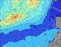 | 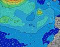 | 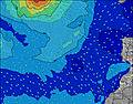 | 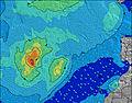 | ||||||||||||||
Wave Height (m) Direction Period (s) | NNE 7 | NNE 7 | NNE 7 | NNE 7 | NNE 7 | NNE 7 | NNE 8 | NNE 8 | NNE 8 | NNE 8 | NNE 8 | NNE 8 | NNE 8 | NNE 8 | NNE 8 | N 8 | N 8 | N 8 | N 8 | N 8 | N 8 |
Wave Graph | |||||||||||||||||||||
335 | 310 | 277 | 352 | 373 | 448 | 526 | 555 | 654 | 908 | 933 | 956 | 1134 | 1003 | 807 | 659 | 476 | 377 | 295 | 245 | 221 | |
Wind (km/h) | |||||||||||||||||||||
Wind State on-shore cross-onshore cross-shore cross-offshore off-shore glassy | cross-off | cross-off | cross-off | cross-off | cross-off | cross-off | cross-off | cross-off | cross-off | cross-off | cross-off | cross-off | cross-off | cross-off | cross-off | cross-off | cross | cross | cross | cross | cross |
High Tide | 8:56PM1.71m | 9:38AM1.71m | 10:14PM1.64m | 10:51AM1.74m | 11:27PM1.67m | 11:53AM1.82m | 00:23AM1.76m | 12:42PM1.94m | 1:07AM1.86m | 1:23PM2.08m | 1:45AM1.97m | 2:00PM2.20m | 2:20AM2.06m | ||||||||
Low Tide | 2:34PM0.81m | 3:08AM0.81m | 3:56PM0.85m | 4:23AM0.84m | 5:13PM0.80m | 5:31AM0.79m | 6:13PM0.70m | 6:23AM0.69m | 6:59PM0.58m | 7:06AM0.57m | 7:38PM0.47m | 7:42AM0.46m | 8:13PM0.36m | ||||||||
7:09 | — | — | 7:09 | — | — | 7:09 | — | — | 7:09 | — | — | 7:11 | — | — | 7:11 | — | — | 7:11 | — | — | |
— | 8:52 | — | — | 8:52 | — | — | 8:51 | — | — | 8:51 | — | — | 8:50 | — | — | 8:50 | — | — | 8:49 | — | |
mm | — | — | — | — | — | — | — | — | — | — | — | — | — | — | — | — | — | — | — | — | — |
Temp °C | 21 | 21 | 20 | 21 | 21 | 20 | 21 | 21 | 20 | 21 | 21 | 20 | 21 | 22 | 21 | 22 | 22 | 21 | 22 | 22 | 20 |
Feels °C | 18 | 18 | 17 | 18 | 17 | 16 | 17 | 17 | 16 | 16 | 15 | 15 | 17 | 18 | 18 | 20 | 20 | 21 | 20 | 20 | 19 |
Swell 1 Height (m) Direction Period (s) | WNW 10 | NW 10 | NW 9 | NW 9 | NW 9 | NW 9 | NW 8 | WNW 8 | WNW 8 | WNW 8 | — | — | WNW 10 | WNW 10 | WNW 9 | WNW 9 | WNW 9 | WNW 9 | N 12 | N 12 | NNW 10 |
38 | 24 | 22 | 21 | 21 | 20 | 18 | 7 | 6 | 7 | — | — | 10 | 9 | 8 | 8 | 8 | 8 | 12 | 23 | 35 | |
Swell 2 Height (m) Direction Period (s) | S 12 | WNW 8 | S 11 | — | — | — | — | — | — | — | — | — | — | — | — | — | — | N 14 | WNW 8 | WNW 8 | WNW 12 |
3 | 6 | 2 | — | — | — | — | — | — | — | — | — | — | — | — | — | — | 4 | 7 | 7 | 14 | |
Swell 3 Height (m) Direction Period (s) | — | S 12 | — | — | — | — | — | — | — | — | — | — | — | — | — | — | — | — | W 13 | NW 13 | NW 8 |
— | 3 | — | — | — | — | — | — | — | — | — | — | — | — | — | — | — | — | 3 | 6 | 3 | |
Wind waves Height (m) Direction Period (s) | NNE 7 | NNE 7 | NNE 7 | NNE 7 | NNE 7 | NNE 7 | NNE 8 | NNE 8 | NNE 8 | NNE 8 | NNE 8 | NNE 8 | NNE 8 | NNE 8 | NNE 8 | N 8 | N 8 | N 8 | N 8 | N 8 | N 8 |
335 | 310 | 277 | 352 | 373 | 448 | 526 | 555 | 654 | 908 | 933 | 956 | 1134 | 1003 | 807 | 659 | 476 | 377 | 295 | 245 | 221 | |
Nearest Offshore or Glassy | |||||||||||||||||||||
Distance (km) | 321 | 321 | 321 | 321 | 321 | 322 | 322 | 514 | 322 | 321 | 321 | 322 | 322 | 322 | 322 | 249 | 223 | 32 | 223 | 223 | 32 |
Best forecast wave conditions in Lanzarote | |||||||||||||||||||||
Best forecast wave conditions in Spain (Africa) | |||||||||||||||||||||
Header Global | |||||||||||||||||||||
- Map Icons:
 Break
Break Live Wave Height (m)
 Live Wind Speed (km/h)
 Surf Rating (10 Max)
 Ocean Swells (m)
- Wind Speed (km/h)


FREE! Surf-Forecast.com widget for your website
The surf report / weather widget below is available to embed on third party websites free of charge and provides a summary of our La Santa - The Slab surf forecast. Simply grab the html code snippet that we provide and paste it into your own site. You can choose your preferred language and metric/imperial units for the surf forecast feed to suit users of your site. Click here to get the code.
Information about the La Santa - The Slab Surf forecast
The above surf forecast table for La Santa - The Slab provides essential information for determining whether the surfing conditions will be good over the next 16 days. A general guide to surfing at La Santa - The Slab can be found by selecting the local surf guide option on the grey menu. Our La Santa - The Slab surf forecast is unique since it includes wave energy (power) that defines the real feel of the surf rather than just the height or the period. If you surf the same spot (La Santa - The Slab) regularly then make a mental note of the wave energy from the surf forecast table each time you go. Very soon you may start to choose your surf days based on the wave energy alone combined with our forecast of favourable offshore wind conditions. Our star ratings will help here and of course you will also find the usual wave height and period predictions on our surf forecasts as well as a full break down of the swell components under our advanced users option (to reveal that, click the little Einstein character under the tide times).
Further information to help with frequently asked questions about our surf forecast for La Santa - The Slab may be found under the help tab on the top menu and also by moving your mouse over the question marks on the surf forecast table itself. Please always bear in mind that the forecast is for near-shore open water and local factors at each surf break influence the actual breaking wave height, such as the beach / reef profile, water depths offshore and shelter.
La Santa - The Slab is 13 km (8 miles) from Teguise. If you plan a holiday in Lanzarote, look for hotels and other accommodation in Teguise. Teguise has rooms for a wide range of budgets as well as car hire and transport links.
 Nearest