
Surf Forecasts:

Fortunes Rocks Beach surf forecast from 2 Aug 2026:
- Best quality surf: Tuesday 4 Aug, 2PM (local time) - 2.5ft (0.8m), 8s period, SSE swell with cross-offshore winds.
- Most powerful swell: Monday 3 Aug, 8PM (local time) - 7ft (2.1m), 8s period, S swell with 504 kJ wave energy.
- Next surfable swell (1★+): Tuesday 4 Aug, 2PM (local time) - 2.5ft (0.8m), 8s period with SSE swell.
Best Forecast Surf Conditions for Fortunes Rocks Beach this week:
The surf forecast for Fortunes Rocks Beach over the next 16 days: The first swell (rated 1 star or higher) is forecast to arrive on Tuesday (Aug 04) at 2PM. The primary swell is predicted to be 0.8m and 8s period with a secondary swell of 0.4m and 3s. The wind is predicted to be cross-offshore as the swell arrives.
The most powerful waves expected at Fortunes Rocks Beach in the next 16 days are 2.1m 8s and forecast to arrive on Monday (Aug 03) at 8PM. Winds are predicted to be cross-offshore at the time the swell arrives. The largest open ocean swell (not directed at the beach) is 0.5m 3s period and expected on Monday (Aug 03) at 11PM.
| Wave Type | Time (EDT) & Date | Wave Height & Period |
|---|---|---|
| Next good surf (1 star+) | 2PM (Tue 4th Aug) | 2.5ft (0.8m) 8s |
| Best Surf | 2PM (Tue 4th Aug) | 2.5ft (0.8m) 8s |
| Most Powerful | 8PM (Mon 3rd Aug) | 7ft (2.1m) 8s |
Table - best surf conditions forecast for Fortunes Rocks Beach over the next 16 days.
The Lowdown
Alright, grab your wettie and listen up. This one’s a bit of a heartbreaker for the next couple weeks. We’re looking at a long, flat stretch ahead, but there’s a tiny blip of something on the horizon that might just save the month.
Honestly, for the first week and a half, you can leave the board in the car. It’s looking pretty grim. We’ve got weak, short-period wind swell bumping in from the SSE, and the winds are mostly going to be on it or cross-onshore, chopping everything up. The water is sitting around 63.5°, which is about 1.3° colder than normal for this time of year, so it’s pretty much what you’d expect. A few mornings will clean up with a light offshore, like Tuesday the 4th, but the swell is just too tiny and weak – we’re talking 2.6ft of knee-high mush. The energy in the water is in the 70s (72), which is nothing to get excited about. It’s just not worth the paddle.
We’ll have a run of days with almost nothing on offer. From the 5th through to the 14th, the swell just dies on its feet. You’ll see days with 0.7ft, 1.3ft, and 1.6ft of slop, and the energy readings are in the single digits to low twenties. There’s a clean, glassy morning on the 12th, but there’s literally no swell to ride. It’s just a flat, shimmering lake. This is the kind of blank run that gets a surfer checking the forecast obsessively.
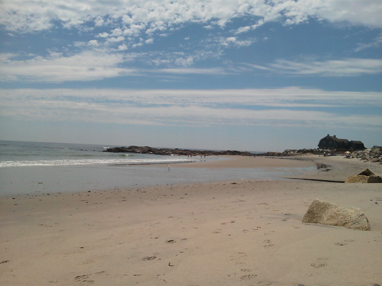
Now, here’s the one true standout in the whole window. It’s a bit of a distant promise, but on Saturday the 15th, the swell finally decides to show up. We’re looking at a jump to 3.9ft on the Saturday morning, pushing to 4.3ft by the afternoon. The direction is S, and while the period is a wonky 6 seconds at first, the energy jumps into the 100s and 200s (108), which tells you there’s finally some push behind it. The winds are light from the SE, so it won’t be perfect, but it’s the only time in this whole 16-day window where you’ll have waves with any sort of size. The break remains Fortunes Rocks Beach, a sandbar setup that’s fairly consistent but isn’t exactly a secret. It’s exposed and can get a bit jumbled, but with that size, it’s a go.
Keep in mind that 4.3ft with that short period is going to be a bit soft and maybe a little bumpy, but it’s about as good as it gets. It’s promising, but with it being so far out, you have to take it with a grain of salt. The long-range calls are just less certain. After that, it fades back down to nothing on the 16th and 17th.
So, there you have it. A long, thirsty wait, and then a chance to wet the whistle on the 15th. But the outlook is mostly about patience. With a sandbar setup and this kind of inconsistency, you just have to bank on the next pulse. Forecasts can change, so keep your eye on it, but don’t hold your breath for the next week.
Stay stoked.
Short Range ForecastHeavy rain (total 22mm), heaviest during Mon afternoon. Warm (max 30°C on Tue afternoon, min 18°C on Mon night). Wind will be generally light. | Days 4-6 Weather SummaryModerate rain (total 12mm), heaviest on Wed afternoon. Warm (max 32°C on Fri afternoon, min 21°C on Wed morning). Wind will be generally light. | ||||||||||||||||||||
Sunday 2 | Monday 3 | Tuesday 4 | Wednesday 5 | Thursday 6 | Friday 7 | Saturday 8 | |||||||||||||||
AM | PM | Night | AM | PM | Night | AM | PM | Night | AM | PM | Night | AM | PM | Night | AM | PM | Night | AM | PM | Night | |
Swell Height Map | 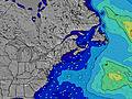 | 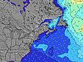 | 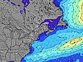 | 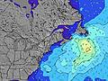 | 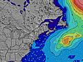 | 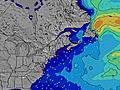 | 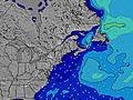 | ||||||||||||||
Wave Height (m) Direction Period (s) | S 5 | SSE 5 | SSE 6 | SSE 5 | SSE 7 | SSE 8 | SSE 8 | SSE 8 | SSE 7 | SSE 7 | SSE 7 | SSE 6 | SSE 6 | SSE 5 | S 6 | SSE 6 | S 6 | SSE 6 | SSE 6 | SE 8 | SE 8 |
Wave Graph | |||||||||||||||||||||
25 | 67 | 65 | 41 | 330 | 243 | 92 | 71 | 18 | 31 | 26 | 23 | 37 | 35 | 153 | 51 | 47 | 18 | 10 | 16 | 9 | |
Wind (km/h) | |||||||||||||||||||||
Wind State on-shore cross-onshore cross-shore cross-offshore off-shore glassy | cross-on | on | on | cross-on | cross-on | cross | cross-off | cross-off | cross-off | cross-on | on | cross | cross-on | cross-on | cross-on | cross | cross-off | cross-off | cross-on | on | cross |
High Tide | 2:23PM2.74m | 2:36AM2.80m | 3:02PM2.81m | 3:20AM2.74m | 3:45PM2.86m | 4:10AM2.65m | 4:33PM2.89m | 5:05AM2.55m | 5:27PM2.91m | 6:07AM2.47m | 6:27PM2.93m | 7:15AM2.44m | 7:33PM2.97m | ||||||||
Low Tide | 8:03AM0.03m | 8:20PM0.17m | 8:41AM0.05m | 9:04PM0.14m | 9:22AM0.09m | 9:54PM0.12m | 10:09AM0.16m | 10:49PM0.12m | 11:01AM0.23m | 11:49PM0.12m | 12:00PM0.29m | 00:56AM0.09m | 1:05PM0.31m | 2:05AM0.03m | |||||||
5:31 | — | — | 5:31 | — | — | 5:33 | — | — | 5:33 | — | — | 5:35 | — | — | 5:37 | — | — | 5:37 | — | — | |
— | 8:02 | — | — | 8:00 | — | — | 8:00 | — | — | 7:59 | — | — | 7:58 | — | — | 7:55 | — | — | 7:54 | — | |
mm | — | — | — | 4 | 17 | 1 | — | — | — | — | 6 | 5 | — | — | — | — | — | 1 | — | — | 1 |
Temp °C | 24 | 24 | 23 | 21 | 23 | 22 | 26 | 30 | 29 | 24 | 22 | 23 | 23 | 28 | 28 | 30 | 32 | 27 | 25 | 26 | 23 |
Feels °C | 23 | 22 | 21 | 20 | 23 | 20 | 22 | 26 | 27 | 23 | 21 | 25 | 24 | 29 | 28 | 30 | 32 | 29 | 26 | 26 | 24 |
Swell 1 Height (m) Direction Period (s) | SE 7 | ESE 9 | SE 9 | SE 9 | — | SSE 8 | SSE 8 | SSE 8 | SSE 5 | SSE 7 | SSE 7 | SSE 6 | E 9 | SE 8 | SSE 6 | SSE 6 | S 6 | SSE 6 | SSE 6 | SE 8 | SE 8 |
13 | 8 | 3 | 3 | — | 243 | 92 | 71 | 15 | 31 | 26 | 23 | 2 | 3 | 119 | 51 | 27 | 18 | 10 | 16 | 9 | |
Swell 2 Height (m) Direction Period (s) | ESE 9 | — | SSE 9 | — | — | — | — | — | SSE 7 | E 10 | — | — | — | E 9 | — | — | — | SSE 8 | SE 8 | SSE 6 | SSE 5 |
8 | — | 8 | — | — | — | — | — | 18 | 2 | — | — | — | 2 | — | — | — | 6 | 10 | 6 | 6 | |
Swell 3 Height (m) Direction Period (s) | SE 9 | — | S 7 | — | — | — | — | — | E 10 | — | — | — | — | — | — | — | — | — | — | — | S 3 |
3 | — | 1 | — | — | — | — | — | 2 | — | — | — | — | — | — | — | — | — | — | — | 1 | |
Wind waves Height (m) Direction Period (s) | S 5 | SSE 5 | SSE 6 | SSE 5 | SSE 7 | — | WSW 3 | WSW 3 | — | — | — | — | SSE 6 | SSE 5 | S 6 | WSW 3 | S 6 | — | — | — | — |
25 | 67 | 65 | 41 | 330 | — | 1 | 1 | — | — | — | — | 37 | 35 | 153 | 4 | 47 | — | — | — | — | |
Nearest Offshore or Glassy | |||||||||||||||||||||
Distance (km) | 569 | 1949 | 1287 | 447 | 448 | 60 | 27 | 27 | 245 | 448 | 934 | 27 | 934 | 261 | 27 | 261 | 261 | 225 | 234 | 651 | 261 |
Best forecast wave conditions in Maine | |||||||||||||||||||||
Best forecast wave conditions in United States | |||||||||||||||||||||
Header Global | |||||||||||||||||||||
- Map Icons:
 Break
Break Live Wave Height (m)
 Live Wind Speed (km/h)
 Surf Rating (10 Max)
 Ocean Swells (m)
- Wind Speed (km/h)
Latest Updates


FREE! Surf-Forecast.com widget for your website
The surf report / weather widget below is available to embed on third party websites free of charge and provides a summary of our Fortunes Rocks Beach surf forecast. Simply grab the html code snippet that we provide and paste it into your own site. You can choose your preferred language and metric/imperial units for the surf forecast feed to suit users of your site. Click here to get the code.
Information about the Fortunes Rocks Beach Surf forecast
The above surf forecast table for Fortunes Rocks Beach provides essential information for determining whether the surfing conditions will be good over the next 16 days. A general guide to surfing at Fortunes Rocks Beach can be found by selecting the local surf guide option on the grey menu. Our Fortunes Rocks Beach surf forecast is unique since it includes wave energy (power) that defines the real feel of the surf rather than just the height or the period. If you surf the same spot (Fortunes Rocks Beach) regularly then make a mental note of the wave energy from the surf forecast table each time you go. Very soon you may start to choose your surf days based on the wave energy alone combined with our forecast of favourable offshore wind conditions. Our star ratings will help here and of course you will also find the usual wave height and period predictions on our surf forecasts as well as a full break down of the swell components under our advanced users option (to reveal that, click the little Einstein character under the tide times).
Further information to help with frequently asked questions about our surf forecast for Fortunes Rocks Beach may be found under the help tab on the top menu and also by moving your mouse over the question marks on the surf forecast table itself. Please always bear in mind that the forecast is for near-shore open water and local factors at each surf break influence the actual breaking wave height, such as the beach / reef profile, water depths offshore and shelter.
Fortunes Rocks Beach is 9 km (6 miles) from Biddeford. If you plan a vacation in Maine, look for hotels and other accommodation in Biddeford. Biddeford has rooms for a wide range of budgets as well as car hire and transport links.
 Nearest