

Surf Forecasts:

Flynns Reef surf forecast from 3 Aug 2026:
- Best quality surf: Monday 10 Aug, 7PM (local time) - 10ft (3.0m), 16s period, SW swell with cross-offshore winds.
- Most powerful swell: Monday 10 Aug, 7AM (local time) - 10ft (3.0m), 18s period, SW swell with 5,466 kJ wave energy.
- Next surfable swell (1★+): Friday 7 Aug, 4PM (local time) - 4ft (1.2m), 15s period with SW swell.
Best Forecast Surf Conditions for Flynns Reef this week:
The surf forecast for Flynns Reef over the next 16 days: The first swell (rated 1 star or higher) is forecast to arrive on Friday (Aug 07) at 4PM. The primary swell is predicted to be 1.2m and 15s period with a secondary swell of 0.7m and 6s. The wind is predicted to be glassy as the swell arrives.
The most powerful waves expected at Flynns Reef in the next 16 days are 3.0m 18s and forecast to arrive on Monday (Aug 10) at 7AM. Winds are predicted to be cross-onshore at the time the swell arrives. The largest open ocean swell (not directed at the beach) is 0.5m 3s period and expected on Saturday (Aug 08) at 7AM.
| Wave Type | Time (AEST) & Date | Wave Height & Period |
|---|---|---|
| Next good surf (1 star+) | 4PM (Fri 7th Aug) | 4ft (1.2m) 15s |
| Best Surf | 7PM (Mon 10th Aug) | 10ft (3.0m) 16s |
| Most Powerful | 7AM (Mon 10th Aug) | 10ft (3.0m) 18s |
Table - best surf conditions forecast for Flynns Reef over the next 16 days.
The Lowdown
G’day, Rusty here. Look, I’ll level with you – this 16-day window for Flynns Reef is a real mixed bag, and honestly, a tough one to call. There’s plenty of swell on the way, but the wind is going to be a persistent problem for most of it. We’ve got a long stretch of poor conditions, but there’s one very brief, golden window that stands out as the only real option for a clean wave.
The pattern sets in early with a solid pulse of SW groundswell. The first few days, from Monday the 3rd right through the rest of that week, are a write-off. Strong winds, mostly cross-onshore, and lumpy, choppy conditions dominate. The swell is there, but it’s just not surfable. By Thursday the 6th, the energy drops right off (combined energy of all swells directed here: 235), and we’re stuck with messy, weak waves. It’s a frustrating start.
The one standout, the only real chance to get a clean one, arrives on Friday the 7th of August. The morning is a bit of a gamble with a light cross-onshore breeze and marginal surf, but the afternoon is where it’s at. The wind swings to a glassy WSW at just 3 mph, turning the 4 ft SW swell (period 15 seconds) into what we all chase. The forecast says “expect very good surf conditions”. With a 15-second period, this is proper groundswell, full of energy (combined energy of all swells directed here: 898), and with that glassy surface, Flynns Reef will be offering up some clean, lined-up waves. This is for the advanced crew, as it’s a reef break and can get a bit tricky, but it’s the best moment on offer. The water temperature is sitting at 56°, which is about normal for this time of year.
After that brief tease, the long-range forecast from the 8th of August onward is a grim story. The swell gets huge, with waves over 8 ft and even 12 ft from the 10th onwards, but the wind continues to howl. We’re talking near-gale force cross-shore and onshore winds, making it blown-out and dangerous. The combined energy values spike massively (like 8532 and 6450), but it’s all raw, unrideable power. A few days in the second week, like Thursday the 13th and Friday the 14th, have bone-rattling 31-34 mph winds. This setup looks more interesting for kite surfing than paddle surfing through that period. There’s a glimmer on Tuesday the 18th with a drop in size to 4 ft, but it’s still cross-onshore and choppy. Don’t plan your life around it.
So, to sum it up: the one and only true standout is Friday afternoon, the 7th of August. Glassy conditions, clean 4 ft groundswell, and that’s your window. The rest of the 16 days is a long, windy gap.
Rusty.
Short Range ForecastModerate rain (total 18mm), heaviest on Mon night. Very mild (max 13°C on Mon afternoon, min 9°C on Mon night). Mainly strong winds. | Days 5-7 Weather SummaryLight rain (total 7mm), mostly falling on Sun morning. Very mild (max 14°C on Sat morning, min 9°C on Fri night). Winds increasing (calm on Fri afternoon, near gales from the N by Sat night). | |||||||||||||||||||
Mon 3 | Tuesday 4 | Wednesday 5 | Thursday 6 | Friday 7 | Saturday 8 | Sunday 9 | ||||||||||||||
PM | Night | AM | PM | Night | AM | PM | Night | AM | PM | Night | AM | PM | Night | AM | PM | Night | AM | PM | Night | |
Swell Height Map |  |  |  | 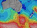 | 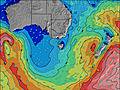 | 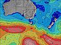 | 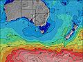 | |||||||||||||
Wave Height (m) Direction Period (s) | SW 15 | SW 14 | SW 11 | SW 12 | SW 10 | SW 20 | SW 19 | SW 18 | SW 12 | SW 16 | SW 18 | SW 16 | SW 15 | SW 14 | SW 16 | SW 16 | SW 15 | SW 15 | WSW 14 | SW 13 |
Wave Graph | ||||||||||||||||||||
1120 | 1058 | 423 | 946 | 392 | 1804 | 2017 | 150 | 93 | 239 | 311 | 773 | 631 | 459 | 844 | 909 | 542 | 492 | 2518 | 1003 | |
Wind (km/h) | ||||||||||||||||||||
Wind State on-shore cross-onshore cross-shore cross-offshore off-shore glassy | on | on | cross-on | cross-on | on | cross-on | on | on | cross-on | cross-on | on | cross-on | glassy | cross-off | cross-off | cross | cross | cross | on | on |
High Tide | 3:24AM2.10m | 3:38PM2.33m | 4:07AM2.18m | 4:09PM2.33m | 4:50AM2.23m | 4:43PM2.32m | 5:36AM2.25m | 5:19PM2.29m | 6:26AM2.24m | 6:01PM2.26m | 7:22AM2.21m | 6:49PM2.20m | ||||||||
Low Tide | 9:23PM0.53m | 9:24AM0.52m | 9:57PM0.40m | 10:03AM0.58m | 10:32PM0.29m | 10:44AM0.65m | 11:10PM0.20m | 11:26AM0.75m | 11:53PM0.14m | 12:12PM0.85m | 00:41AM0.12m | 1:05PM0.96m | 1:36AM0.14m | |||||||
— | — | 7:18 | — | — | 7:16 | — | — | 7:16 | — | — | 7:15 | — | — | 7:13 | — | — | 7:13 | — | — | |
5:30 | — | — | 5:31 | — | — | 5:32 | — | — | 5:34 | — | — | 5:35 | — | — | 5:36 | — | — | 5:36 | — | |
mm | — | 4 | 2 | 2 | 7 | 2 | 1 | — | — | 1 | — | — | — | — | — | — | 3 | 3 | 1 | 3 |
Temp °C | 13 | 10 | 11 | 12 | 12 | 12 | 12 | 12 | 9 | 13 | 12 | 10 | 13 | 11 | 14 | 14 | 13 | 11 | 11 | 12 |
Feels °C | 6 | 4 | 3 | 5 | 8 | 7 | 4 | 6 | 3 | 7 | 4 | 7 | 11 | 6 | 7 | 7 | 3 | 0 | 1 | 3 |
Swell 1 Height (m) Direction Period (s) | SW 15 | SW 18 | SW 11 | — | SW 10 | WSW 11 | SW 19 | SW 6 | SW 5 | SW 16 | SW 18 | SW 16 | SW 15 | SW 14 | SW 16 | SW 16 | SW 15 | SW 15 | — | SW 13 |
1120 | 12 | 423 | — | 392 | 101 | 175 | 69 | 41 | 239 | 311 | 773 | 631 | 459 | 844 | 909 | 542 | 492 | — | 1003 | |
Swell 2 Height (m) Direction Period (s) | — | SSW 18 | SW 13 | — | SW 21 | SW 20 | SSW 19 | SW 13 | SW 12 | SW 5 | SW 14 | SW 6 | SSW 6 | SW 18 | — | — | WSW 18 | — | — | SW 19 |
— | 30 | 320 | — | 69 | 186 | 36 | 136 | 93 | 13 | 130 | 58 | 33 | 307 | — | — | 127 | — | — | 925 | |
Swell 3 Height (m) Direction Period (s) | — | — | — | — | SW 20 | SW 14 | — | SW 18 | SW 16 | SW 20 | WSW 11 | — | SW 19 | SSW 6 | — | — | — | — | — | — |
— | — | — | — | 16 | 93 | — | 150 | 93 | 15 | 47 | — | 234 | 15 | — | — | — | — | — | — | |
Wind waves Height (m) Direction Period (s) | NW 4 | SW 14 | NW 4 | SW 12 | — | SW 20 | SW 19 | SW 6 | NW 4 | NW 3 | SW 7 | WSW 7 | — | — | NNW 3 | NNW 4 | NNW 4 | WNW 5 | WSW 14 | NW 5 |
13 | 1058 | 19 | 946 | — | 1804 | 2017 | 116 | 8 | 5 | 140 | 82 | — | — | 3 | 5 | 44 | 118 | 2518 | 63 | |
Nearest Offshore or Glassy | ||||||||||||||||||||
Distance (km) | 102 | 70 | 100 | 84 | 10 | 73 | 73 | 4 | 10 | 32 | 10 | 2 | 0 | 7 | 9 | 22 | 94 | 531 | 531 | 457 |
Best forecast wave conditions in Phillip Island | ||||||||||||||||||||
Best forecast wave conditions in Australia | ||||||||||||||||||||
Header Global | ||||||||||||||||||||
- Map Icons:
 Break
Break Live Wave Height (m)
 Live Wind Speed (km/h)
 Surf Rating (10 Max)
 Ocean Swells (m)
- Wind Speed (km/h)
Latest Updates


FREE! Surf-Forecast.com widget for your website
The surf report / weather widget below is available to embed on third party websites free of charge and provides a summary of our Flynns Reef surf forecast. Simply grab the html code snippet that we provide and paste it into your own site. You can choose your preferred language and metric/imperial units for the surf forecast feed to suit users of your site. Click here to get the code.
Information about the Flynns Reef Surf forecast
The above surf forecast table for Flynns Reef provides essential information for determining whether the surfing conditions will be good over the next 16 days. A general guide to surfing at Flynns Reef can be found by selecting the local surf guide option on the grey menu. Our Flynns Reef surf forecast is unique since it includes wave energy (power) that defines the real feel of the surf rather than just the height or the period. If you surf the same spot (Flynns Reef) regularly then make a mental note of the wave energy from the surf forecast table each time you go. Very soon you may start to choose your surf days based on the wave energy alone combined with our forecast of favourable offshore wind conditions. Our star ratings will help here and of course you will also find the usual wave height and period predictions on our surf forecasts as well as a full break down of the swell components under our advanced users option (to reveal that, click the little Einstein character under the tide times).
Further information to help with frequently asked questions about our surf forecast for Flynns Reef may be found under the help tab on the top menu and also by moving your mouse over the question marks on the surf forecast table itself. Please always bear in mind that the forecast is for near-shore open water and local factors at each surf break influence the actual breaking wave height, such as the beach / reef profile, water depths offshore and shelter.
Flynns Reef is 32 km (20 miles) from Mornington. If you plan a holiday in Phillip Island, look for hotels and other accommodation in Mornington. Mornington has rooms for a wide range of budgets as well as car hire and transport links.
 Nearest