

Surf Forecasts:

Blue Bowls surf forecast from 1 Aug 2026:
- Most powerful swell: Wednesday 5 Aug, 8AM (local time) - 4.5ft (1.3m), 19s period, SSW swell with 1,085 kJ wave energy.
Best Forecast Surf Conditions for Blue Bowls this week:
The most powerful waves expected at Blue Bowls in the next 16 days are 1.3m 19s and forecast to arrive on Wednesday (Aug 05) at 8AM. Winds are predicted to be cross-onshore at the time the swell arrives. The largest open ocean swell (not directed at the beach) is 1.0m 11s period and expected on Sunday (Aug 02) at 5AM.
| Wave Type | Time (+05) & Date | Wave Height & Period |
|---|---|---|
| Next good surf (1 star+) | - | - |
| Best Surf | - | - |
| Most Powerful | 8AM (Wed 5th Aug) | 4.5ft (1.3m) 19s |
Table - best surf conditions forecast for Blue Bowls over the next 16 days.
The Lowdown
Alright folks, Rusty here. Let’s take a look at what’s cooking at Blue Bowls over the next couple of weeks.
Right off the bat, I gotta be honest with you – the start of this run is a bit of a struggle. We’ve got waves, but the wind is mostly cross-onshore, which is messing with the surface. The tide and the overall conditions are just feeling a bit off for the first few days. The wait for some proper clean surf is going to be a real test of patience.
Sunday the 2nd and Monday the 3rd see some small, long-period swell rolling in from the SSW, around 4ft to 4ft with a period of 16 seconds – that’s proper groundswell energy. The combined energy is sitting at 503 to 962, which is moderate to strong. But the light cross-onshore breeze is putting a cap on the quality. It’s surfable, but it’s not going to be pretty.
Tuesday the 4th is pretty similar, with the swell dropping a touch to 3ft. Same story with the wind and the tide issues. We’re just marking time here.
The mid-week period from Wednesday the 5th through to Friday the 7th looks a bit more promising on the size front. The swell bumps up to 5ft to 6ft, with a shorter period, around 10-11 seconds, coming from the SSE. The combined energy is strong, hitting values like 1286 and 1183. But here’s the kicker – the wind is still cross-onshore, and by Thursday the 6th and Friday the 7th, we’re reading “poor surf conditions” with a score of zero. That’s a big red flag. The waves will be there, but it’s going to be choppy and messy. Not what you want.
Saturday the 8th through Monday the 11th is a real write-off, to be honest. The swell sticks around 5ft to 6ft, but the winds are up and the entire period is flagged as “poor surf conditions.” It’s a lot of wind for not a lot of payoff. At this stage, the setup looks more interesting for kite surfing than paddle surfing.
Now, finally, we get to the light at the end of the tunnel. Around Thursday the 13th, something shifts. The wind swings to the west, going cross-offshore. That’s the magic word: clean. The swell is smaller, around 5ft in the morning, but the conditions are “clean.” The combined energy is moderate at 606. It’s a morning worth checking for a surfer who knows the rock.
But the real standout – the one you want to circle on your calendar – is Friday the 14th of August. This is the best on offer. The morning brings a clean 4ft SE swell with a 10-second period, but the wind is a light, cross-offshore breeze from the west. The combined energy is 658. The afternoon is even better: a 3ft SSW swell with a 16-second period (more of that lovely groundswell energy) and a light 6 mph cross-offshore wind. The report says “expect very good surf conditions.” This is the day. The crowds are “sometimes” an issue here, but for conditions this clean, you’ll want to be in the water. The water temperature is about average for the time of year.
After the Friday high, the weekend tails off. Saturday the 15th has a small 3ft SSW swell, but the wind goes back onshore, and by Sunday the 16th, it’s another poor run. The last day, Monday the 17th, keeps the trend of small, poor-quality surf.
So, to sum it up: the first week is a grind with messy wind and poor conditions. The second week starts to clean up, with Thursday the 13th being a glimmer of hope, and Friday the 14th being the absolute standout. Make a plan for that Friday.
Rusty.
Short Range ForecastLight rain (total 4mm), mostly falling on Sun night. Warm (max 28°C on Sat night, min 27°C on Sun night). Wind will be generally light. | Days 5-7 Weather SummaryMostly dry. Warm (max 28°C on Tue night, min 27°C on Tue night). Wind will be generally light. | ||||||||||||||||||
Sunday 2 | Monday 3 | Tuesday 4 | Wednesday 5 | Thursday 6 | Friday 7 | ||||||||||||||
Night | AM | PM | Night | AM | PM | Night | AM | PM | Night | AM | PM | Night | AM | PM | Night | AM | PM | Night | |
Swell Height Map |  | 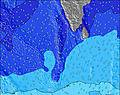 | 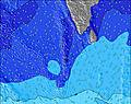 | 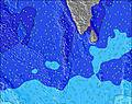 | 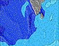 | 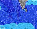 | 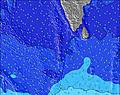 | ||||||||||||
Wave Height (m) Direction Period (s) | SSW 14 | SE 9 | SSW 16 | SSW 16 | SSW 16 | SSW 16 | SSW 15 | SSW 15 | SSW 15 | S 20 | SSW 18 | SSW 17 | SSW 16 | SSE 10 | SSE 9 | SSE 10 | SSE 11 | SSE 11 | SSE 10 |
Wave Graph | |||||||||||||||||||
338 | 281 | 627 | 612 | 761 | 733 | 661 | 405 | 405 | 485 | 972 | 813 | 540 | 471 | 495 | 518 | 745 | 798 | 637 | |
Wind (km/h) | |||||||||||||||||||
Wind State on-shore cross-onshore cross-shore cross-offshore off-shore glassy | cross-on | cross-on | cross-on | on | on | cross-on | cross-on | cross | cross-on | cross | cross-on | cross-on | cross-on | on | cross-on | cross-on | cross-on | cross-on | cross-on |
High Tide | 3:26AM0.98m | 3:40PM1.10m | 4:00AM0.97m | 4:04PM1.05m | 4:38AM0.95m | 4:28PM0.99m | 5:21AM0.90m | 4:54PM0.91m | 6:19AM0.83m | 5:22PM0.82m | 7:56AM0.77m | 5:58PM0.73m | |||||||
Low Tide | 9:27PM0.19m | 9:22AM0.18m | 9:54PM0.17m | 9:53AM0.24m | 10:24PM0.17m | 10:26AM0.32m | 10:56PM0.17m | 11:03AM0.41m | 11:35PM0.20m | 11:48AM0.51m | 00:28AM0.24m | 1:05PM0.61m | 1:53AM0.27m | ||||||
— | 6:09 | — | — | 6:09 | — | — | 6:09 | — | — | 6:09 | — | — | 6:09 | — | — | 6:09 | — | — | |
— | — | 6:16 | — | — | 6:16 | — | — | 6:15 | — | — | 6:15 | — | — | 6:15 | — | — | 6:15 | — | |
mm | — | — | — | 1 | — | — | 2 | — | 1 | — | — | — | — | — | — | — | — | — | — |
Temp °C | 28 | 28 | 28 | 28 | 28 | 28 | 28 | 27 | 28 | 28 | 27 | 28 | 28 | 27 | 28 | 27 | 27 | 28 | 28 |
Feels °C | 30 | 30 | 31 | 31 | 31 | 31 | 32 | 30 | 31 | 31 | 29 | 30 | 30 | 29 | 30 | 28 | 30 | 30 | 30 |
Swell 1 Height (m) Direction Period (s) | SE 9 | SE 9 | SE 9 | SE 9 | SSW 16 | SSW 16 | SSW 15 | SSW 15 | SSW 15 | SSW 15 | SSW 18 | SSE 9 | SSE 10 | SSE 10 | SSE 9 | SSE 10 | SSE 11 | SSE 11 | SSE 10 |
338 | 281 | 249 | 293 | 761 | 733 | 661 | 405 | 405 | 461 | 972 | 301 | 443 | 471 | 495 | 518 | 745 | 798 | 637 | |
Swell 2 Height (m) Direction Period (s) | NW 11 | NW 11 | SSW 16 | SSW 16 | SE 8 | SSE 8 | SE 8 | S 8 | S 9 | S 10 | SE 9 | SSW 17 | SSW 16 | SSW 15 | SSW 14 | S 18 | S 17 | S 16 | S 18 |
224 | 194 | 627 | 612 | 201 | 179 | 82 | 58 | 99 | 164 | 155 | 813 | 540 | 360 | 276 | 308 | 371 | 343 | 294 | |
Swell 3 Height (m) Direction Period (s) | SSW 14 | SSW 13 | NW 11 | NW 10 | WNW 9 | NW 9 | NW 8 | SSW 18 | SE 9 | S 20 | S 10 | NW 7 | ESE 8 | NW 7 | S 19 | SSW 14 | SSW 13 | NW 8 | S 13 |
290 | 222 | 169 | 145 | 108 | 81 | 70 | 280 | 62 | 485 | 159 | 26 | 44 | 13 | 173 | 195 | 67 | 18 | 128 | |
Wind waves Height (m) Direction Period (s) | — | — | — | — | — | — | — | — | — | — | — | — | — | — | — | — | — | — | — |
— | — | — | — | — | — | — | — | — | — | — | — | — | — | — | — | — | — | — | |
Nearest Offshore or Glassy | |||||||||||||||||||
Distance (km) | 1051 | 175 | 175 | 175 | 175 | 58 | 58 | 58 | 58 | 58 | 58 | 1066 | 1051 | 1201 | 1201 | 175 | 175 | 1201 | 1208 |
Best forecast wave conditions in Huvadhoo Atoll | |||||||||||||||||||
Best forecast wave conditions in Maldives | |||||||||||||||||||
Header Global | |||||||||||||||||||
- Map Icons:
 Break
Break Live Wave Height (m)
 Live Wind Speed (km/h)
 Surf Rating (10 Max)
 Ocean Swells (m)
- Wind Speed (km/h)
Latest Updates


FREE! Surf-Forecast.com widget for your website
The surf report / weather widget below is available to embed on third party websites free of charge and provides a summary of our Blue Bowls surf forecast. Simply grab the html code snippet that we provide and paste it into your own site. You can choose your preferred language and metric/imperial units for the surf forecast feed to suit users of your site. Click here to get the code.
Information about the Blue Bowls Surf forecast
The above surf forecast table for Blue Bowls provides essential information for determining whether the surfing conditions will be good over the next 16 days. A general guide to surfing at Blue Bowls can be found by selecting the local surf guide option on the grey menu. Our Blue Bowls surf forecast is unique since it includes wave energy (power) that defines the real feel of the surf rather than just the height or the period. If you surf the same spot (Blue Bowls) regularly then make a mental note of the wave energy from the surf forecast table each time you go. Very soon you may start to choose your surf days based on the wave energy alone combined with our forecast of favourable offshore wind conditions. Our star ratings will help here and of course you will also find the usual wave height and period predictions on our surf forecasts as well as a full break down of the swell components under our advanced users option (to reveal that, click the little Einstein character under the tide times).
Further information to help with frequently asked questions about our surf forecast for Blue Bowls may be found under the help tab on the top menu and also by moving your mouse over the question marks on the surf forecast table itself. Please always bear in mind that the forecast is for near-shore open water and local factors at each surf break influence the actual breaking wave height, such as the beach / reef profile, water depths offshore and shelter.
Blue Bowls is 102 km (63 miles) from the city of Gan. If you plan a holiday in Huvadhoo Atoll, look for hotels and other accommodation in Gan. Gan has rooms for a wide range of budgets as well as car hire and transport links.
 Nearest