

Surf Forecasts:

Colas (Cokes) surf forecast from 29 Jul 2026:
- Best quality surf: Saturday 1 Aug, 5PM (local time) - 3ft (0.9m), 15s period, SSW swell with cross-offshore winds.
- Most powerful swell: Wednesday 5 Aug, 5PM (local time) - 3.5ft (1.1m), 18s period, SSW swell with 762 kJ wave energy.
- Next surfable swell (1★+): Saturday 1 Aug, 11AM (local time) - 2.5ft (0.8m), 16s period with SSW swell.
Best Forecast Surf Conditions for Colas (Cokes) this week:
The surf forecast for Colas (Cokes) over the next 16 days: The first swell (rated 1 star or higher) is forecast to arrive on Saturday (Aug 01) at 11AM. The primary swell is predicted to be 0.8m and 16s period with a secondary swell of 0.9m and 10s. The wind is predicted to be cross-offshore as the swell arrives.
The most powerful waves expected at Colas (Cokes) in the next 16 days are 1.1m 18s and forecast to arrive on Wednesday (Aug 05) at 5PM. Winds are predicted to be cross-offshore at the time the swell arrives. The largest open ocean swell (not directed at the beach) is 2.5m 6s period and expected on Friday (Jul 31) at 5PM.
| Wave Type | Time (+05) & Date | Wave Height & Period |
|---|---|---|
| Next good surf (1 star+) | 11AM (Sat 1st Aug) | 2.5ft (0.8m) 16s |
| Best Surf | 5PM (Sat 1st Aug) | 3ft (0.9m) 15s |
| Most Powerful | 5PM (Wed 5th Aug) | 3.5ft (1.1m) 18s |
Table - best surf conditions forecast for Colas (Cokes) over the next 16 days.
The Lowdown
Alright, let’s talk in feet and Fahrenheit for the imperial crew.
Colas is a reef, exposed, and it’s looking for swell from the SE. Water temp is about 86°, which is a hair warmer than normal for this time of year.
The surf starts slow on Wednesday, July 29th. A tiny 2ft SSW swell with a long 18-second period. Wind is cross-off from the W at 16 mph, keeping it clean. The energy is moderate (538). It’s a marginal one. Thursday and Friday are not much better, with small cross-off swell and stronger wind.
The first real window to get excited about is Saturday, August 1st. Light breeze, cross-off, with a 3ft SSW swell at 15 seconds. The energy is moderate (579), and the conditions are looking very good. That’s the best of the early days.
Sunday, August 2nd afternoon, the wind goes offshore from the NW at 9 mph, with a 3ft S swell. The period drops to 8 seconds, so it’s weaker, but that offshore wind will make it glassy. The energy is lower (213), but it’s a fun little session.
The second week builds. On Wednesday, August 12th, the swell jumps to 7ft from the SSE with an 11-second period. The energy is strong (1386). The wind is cross-off from the WSW at 16 mph, so it’s clean. That’s a big, powerful swell for the reef—this is for experts only. Thursday, August 13th morning holds similar size, 7ft from the SSE, with even higher energy (1448).
The absolute standout is Thursday, August 13th afternoon. The swell drops to 4ft, but it’s a long-period S swell at 18 seconds. The energy is very strong (1636). That kind of long, clean groundswell on the reef will produce some beautiful, long, peeling waves. The wind is cross-off from the W at 16 mph. That’s the one to wait for. It’s over a week out, so it’s a long-range promise, but if it delivers, it’s the best of the whole 16 days.
Rusty, signing off.
Short Range ForecastHeavy rain (total 81mm), heaviest during Fri night. Warm (max 28°C on Wed afternoon, min 24°C on Fri night). Winds decreasing (near gales from the W on Fri night, light winds from the W by Sat morning). | Days 5-7 Weather SummaryModerate rain (total 11mm), heaviest on Sun morning. Warm (max 28°C on Sat afternoon, min 26°C on Sun morning). Wind will be generally light. | |||||||||||||||||||
Wed 29 | Thursday 30 | Friday 31 | Saturday 1 | Sunday 2 | Monday 3 | Tuesday 4 | ||||||||||||||
PM | Night | AM | PM | Night | AM | PM | Night | AM | PM | Night | AM | PM | Night | AM | PM | Night | AM | PM | Night | |
Swell Height Map |  | 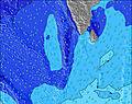 | 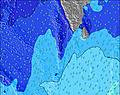 | 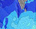 | 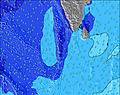 | 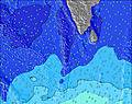 |  | |||||||||||||
Wave Height (m) Direction Period (s) | SSW 18 | SSW 18 | SSW 16 | SE 10 | SE 10 | SSW 18 | SE 10 | SSW 16 | SSW 16 | SSW 15 | SSW 14 | SSW 14 | SE 9 | S 9 | SSW 15 | SSW 17 | SSW 16 | SSW 16 | SSW 15 | SSW 15 |
Wave Graph | ||||||||||||||||||||
292 | 360 | 302 | 192 | 200 | 491 | 204 | 532 | 277 | 372 | 321 | 243 | 107 | 181 | 240 | 563 | 505 | 506 | 468 | 339 | |
Wind (km/h) | ||||||||||||||||||||
Wind State on-shore cross-onshore cross-shore cross-offshore off-shore glassy | cross-off | cross-off | cross-off | cross-off | cross-off | cross-off | cross-off | cross-off | cross-off | cross-off | cross-off | cross-off | off | cross-off | cross-off | cross-off | cross-off | cross-off | cross-off | cross-off |
High Tide | 1:23AM0.65m | 2:03PM0.93m | 1:57AM0.70m | 2:26PM0.95m | 2:30AM0.74m | 2:48PM0.95m | 3:03AM0.77m | 3:10PM0.92m | 3:38AM0.79m | 3:31PM0.88m | 4:16AM0.78m | 3:51PM0.82m | 4:59AM0.76m | |||||||
Low Tide | 7:57PM0.26m | 7:16AM0.10m | 8:19PM0.23m | 7:47AM0.11m | 8:42PM0.19m | 8:18AM0.14m | 9:05PM0.16m | 8:49AM0.18m | 9:29PM0.14m | 9:21AM0.24m | 9:54PM0.12m | 9:54AM0.30m | 10:23PM0.11m | |||||||
— | — | 6:01 | — | — | 6:01 | — | — | 6:01 | — | — | 6:01 | — | — | 6:01 | — | — | 6:01 | — | — | |
6:21 | — | — | 6:21 | — | — | 6:21 | — | — | 6:20 | — | — | 6:20 | — | — | 6:20 | — | — | 6:20 | — | |
mm | 5 | 2 | 4 | 2 | 7 | 10 | 10 | 38 | 3 | 2 | — | 5 | — | 2 | 2 | — | — | — | — | 3 |
Temp °C | 28 | 28 | 28 | 28 | 28 | 27 | 26 | 26 | 27 | 28 | 28 | 27 | 27 | 28 | 28 | 28 | 28 | 28 | 28 | 28 |
Feels °C | 28 | 29 | 29 | 29 | 28 | 28 | 27 | 24 | 27 | 30 | 30 | 30 | 28 | 30 | 31 | 29 | 29 | 30 | 29 | 29 |
Swell 1 Height (m) Direction Period (s) | WNW 9 | SE 10 | WNW 8 | WNW 8 | WNW 8 | SE 10 | SE 10 | W 8 | NW 9 | SSW 15 | NW 10 | NW 11 | WNW 9 | WNW 10 | SSE 8 | SSE 8 | SSW 16 | SSW 16 | SSW 15 | WNW 9 |
190 | 213 | 140 | 125 | 142 | 204 | 204 | 573 | 328 | 372 | 471 | 408 | 288 | 246 | 190 | 157 | 505 | 506 | 468 | 116 | |
Swell 2 Height (m) Direction Period (s) | SE 10 | WNW 8 | SE 10 | SE 10 | SE 10 | SSW 18 | S 10 | SSW 16 | SE 10 | SE 10 | SSW 14 | S 8 | S 8 | S 9 | NW 9 | NW 8 | WNW 10 | WNW 9 | WNW 9 | SSW 15 |
246 | 157 | 188 | 192 | 200 | 491 | 98 | 532 | 154 | 148 | 321 | 111 | 107 | 181 | 170 | 158 | 164 | 148 | 164 | 339 | |
Swell 3 Height (m) Direction Period (s) | SSW 18 | SSW 18 | SSW 16 | S 11 | S 11 | S 10 | S 10 | SE 10 | SSW 16 | S 9 | SE 10 | SSW 14 | SE 9 | SSW 13 | SSW 15 | SSW 17 | SSE 8 | SSE 8 | S 7 | S 8 |
292 | 360 | 302 | 125 | 149 | 131 | 96 | 151 | 277 | 59 | 117 | 243 | 106 | 116 | 240 | 563 | 109 | 104 | 54 | 40 | |
Wind waves Height (m) Direction Period (s) | — | — | — | — | — | WNW 8 | WSW 6 | — | WSW 8 | NW 10 | — | — | — | — | — | — | — | — | W 3 | WNW 3 |
— | — | — | — | — | 191 | 564 | — | 151 | 587 | — | — | — | — | — | — | — | — | 1 | 4 | |
Nearest Offshore or Glassy | ||||||||||||||||||||
Distance (km) | 262 | 1082 | 262 | 262 | 406 | 948 | 948 | 949 | 0 | 0 | 11 | 3 | 0 | 0 | 0 | 262 | 262 | 262 | 262 | 262 |
Best forecast wave conditions in North Male Atoll | ||||||||||||||||||||
Best forecast wave conditions in Maldives | ||||||||||||||||||||
Header Global | ||||||||||||||||||||
- Map Icons:
 Break
Break Live Wave Height (m)
 Live Wind Speed (km/h)
 Surf Rating (10 Max)
 Ocean Swells (m)
- Wind Speed (km/h)


FREE! Surf-Forecast.com widget for your website
The surf report / weather widget below is available to embed on third party websites free of charge and provides a summary of our Colas (Cokes) surf forecast. Simply grab the html code snippet that we provide and paste it into your own site. You can choose your preferred language and metric/imperial units for the surf forecast feed to suit users of your site. Click here to get the code.
Information about the Colas (Cokes) Surf forecast
The above surf forecast table for Colas (Cokes) provides essential information for determining whether the surfing conditions will be good over the next 16 days. A general guide to surfing at Colas (Cokes) can be found by selecting the local surf guide option on the grey menu. Our Colas (Cokes) surf forecast is unique since it includes wave energy (power) that defines the real feel of the surf rather than just the height or the period. If you surf the same spot (Colas (Cokes)) regularly then make a mental note of the wave energy from the surf forecast table each time you go. Very soon you may start to choose your surf days based on the wave energy alone combined with our forecast of favourable offshore wind conditions. Our star ratings will help here and of course you will also find the usual wave height and period predictions on our surf forecasts as well as a full break down of the swell components under our advanced users option (to reveal that, click the little Einstein character under the tide times).
Further information to help with frequently asked questions about our surf forecast for Colas (Cokes) may be found under the help tab on the top menu and also by moving your mouse over the question marks on the surf forecast table itself. Please always bear in mind that the forecast is for near-shore open water and local factors at each surf break influence the actual breaking wave height, such as the beach / reef profile, water depths offshore and shelter.
Are you planning a holiday in North Male Atoll? If you are looking for accommodation near Colas, camping, hotels and holiday cottages in North Male Atoll, consider staying in Male which is 50 km (31 miles) away.
 Nearest