

Surf Forecasts:

Castaways surf forecast from 4 Jul 2026:
- Best quality surf: Thursday 9 Jul, 11AM (local time) - 4ft (1.2m), 14s period, SSW swell with glassy winds.
- Most powerful swell: Saturday 11 Jul, 11PM (local time) - 4.5ft (1.3m), 14s period, S swell with 613 kJ wave energy.
- Next surfable swell (1★+): Monday 6 Jul, 11AM (local time) - 2.5ft (0.8m), 15s period with SSW swell.
Best Forecast Surf Conditions for Castaways this week:
The surf forecast for Castaways over the next 16 days: The first swell (rated 1 star or higher) is forecast to arrive on Monday (Jul 06) at 11AM. The primary swell is predicted to be 0.8m and 15s period with a secondary swell of 1.3m and 9s. The wind is predicted to be cross-offshore as the swell arrives.
The most powerful waves expected at Castaways in the next 16 days are 1.3m 14s and forecast to arrive on Saturday (Jul 11) at 11PM. Winds are predicted to be glassy at the time the swell arrives. The largest open ocean swell (not directed at the beach) is 0.5m 4s period and expected on Sunday (Jul 05) at 5AM.
| Wave Type | Time (+05) & Date | Wave Height & Period |
|---|---|---|
| Next good surf (1 star+) | 11AM (Mon 6th Jul) | 2.5ft (0.8m) 15s |
| Best Surf | 11AM (Thu 9th Jul) | 4ft (1.2m) 14s |
| Most Powerful | 11PM (Sat 11th Jul) | 4.5ft (1.3m) 14s |
Table - best surf conditions forecast for Castaways over the next 16 days.
Updates in hr min s Forecast update imminent
G’day, Rusty here. Let’s talk about Castaways, the only wave on the radar for the next couple weeks. It’s an advanced, exposed reef break that works best with a SSW swell. It breaks fairly consistently, but this isn’t a beginner spot – you need to know what you’re doing.
The forecast kicks off a bit flat and sloppy. Sunday July 5 is nothing to write home about: morning has a small 3ft SSW groundswell with a very long 16-second period, but a cross-off breeze keeps it average. Afternoon gets a little bigger at 4ft from the SE, but shorter period and moderate wave energy (563). Tide might mess with you too.
Then things clean up. Monday July 6 through Wednesday July 8 start to glass off nicely. Monday morning is glassy with 3ft SSW swell, 15-second periods, wave energy at 656 (moderate). Tuesday is even better: both sessions are glassy, winds nearly zero, swell stays around 3–3ft from the SSW, period 14 seconds, energy 560–625. Clean, fun, small but lined up.
The real standout is Thursday July 9. Both morning and afternoon are dead calm, glassy, with a solid 4ft SSW swell, 14-second period, and wave energy climbing over 1000 (1035 in the morning, 1028 afternoon). That’s strong, quality energy hitting the reef from the ideal direction. Water temp is about normal for the season. Get out early, you might have it to yourself – crowds are only sometimes a problem. The long period will make it run nicely down the reef.
Friday and Saturday, July 10 and 11, continue with glassy conditions, swell around 4–4ft from the SSW (and a brief NW shift Friday morning). Energy stays solid (913 Friday morning). Still fun, but Thursday was the best.
Sunday July 12 sees a S swell building to 5ft, 13-second period, glassy wind, energy at 863. That’s getting into more serious territory – experienced surfers only. That holds into Monday July 13, with 4ft from the S, glassy morning.
Then it turns ugly. From Tuesday July 14 afternoon, it gets cross-on. Wednesday July 15 is onshore S wind at 10 km/h, making it choppy and marginal. Thursday July 16 through Sunday July 19 is a mess: SE wind at 20–25 km/h, cross-on, short-period swell, wave energy dropping, and lumpy conditions. On Monday July 20, a bigger 6ft SSE swell (11 seconds) arrives, but with that strong cross-on wind, it’s just a choppy, poor surf day – more for kite riding than paddle surfing.
Bottom line: if you can make it out on Thursday July 9, that’s your day. Tuesday July 14 afternoon might offer a glassy window with a long period SSW swell, but it’s not as strong. After that, expect a week of poor conditions. Take the good ones while they’re here.
Rusty.
Short Range ForecastMostly dry. Warm (max 28°C on Sat night, min 27°C on Sun night). Wind will be generally light. | Days 5-7 Weather SummaryMostly dry. Warm (max 28°C on Tue night, min 27°C on Tue night). Wind will be generally light. | ||||||||||||||||||||
Sunday 5 | Monday 6 | Tuesday 7 | Wednesday 8 | Thursday 9 | Friday 10 | Sat 11 | |||||||||||||||
Night | AM | PM | Night | AM | PM | Night | AM | PM | Night | AM | PM | Night | AM | PM | Night | AM | PM | Night | AM | PM | |
Swell Height Map | 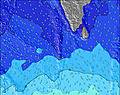 | 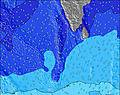 | 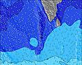 | 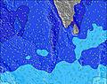 | 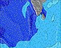 | 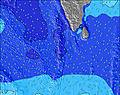 | 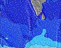 | 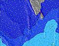 | |||||||||||||
Wave Height (m) Direction Period (s) | SW 16 | SSW 16 | SE 9 | SSE 9 | SSW 15 | SSW 16 | SSW 15 | SSW 14 | SSW 14 | S 14 | SSW 13 | SSW 14 | SSW 14 | SSW 14 | SSW 14 | SSW 13 | NW 11 | SSW 13 | SSW 12 | SSW 12 | SSW 11 |
Wave Graph | |||||||||||||||||||||
264 | 306 | 258 | 276 | 291 | 382 | 344 | 299 | 236 | 264 | 303 | 459 | 373 | 527 | 549 | 475 | 414 | 431 | 211 | 306 | 314 | |
Wind (km/h) | |||||||||||||||||||||
Wind State on-shore cross-onshore cross-shore cross-offshore off-shore glassy | cross-off | cross-off | cross-off | cross-off | cross-off | cross-off | cross-off | glassy | glassy | glassy | glassy | cross | glassy | glassy | glassy | glassy | glassy | glassy | glassy | glassy | glassy |
High Tide | 4:14AM0.84m | 4:38PM1.01m | 4:59AM0.82m | 5:07PM0.96m | 5:53AM0.81m | 5:40PM0.89m | 7:04AM0.79m | 6:20PM0.82m | 8:41AM0.79m | 7:18PM0.74m | 10:22AM0.84m | 8:51PM0.69m | 11:38AM0.91m | ||||||||
Low Tide | 10:25PM0.29m | 10:08AM0.25m | 11:00PM0.29m | 10:46AM0.33m | 11:39PM0.28m | 11:31AM0.42m | 00:25AM0.27m | 12:32PM0.51m | 1:23AM0.26m | 2:06PM0.58m | 2:38AM0.23m | 4:18PM0.58m | 4:00AM0.19m | 5:52PM0.53m | |||||||
— | 6:07 | — | — | 6:07 | — | — | 6:07 | — | — | 6:07 | — | — | 6:07 | — | — | 6:07 | — | — | 6:07 | — | |
— | — | 6:15 | — | — | 6:15 | — | — | 6:15 | — | — | 6:15 | — | — | 6:15 | — | — | 6:15 | — | — | 6:15 | |
mm | — | — | — | — | — | — | — | — | — | — | — | — | — | — | — | — | — | — | — | — | — |
Temp °C | 28 | 28 | 28 | 28 | 28 | 28 | 28 | 27 | 28 | 28 | 27 | 28 | 28 | 27 | 28 | 28 | 27 | 28 | 28 | 27 | 28 |
Feels °C | 28 | 29 | 29 | 29 | 30 | 30 | 30 | 30 | 31 | 31 | 31 | 31 | 32 | 31 | 33 | 32 | 31 | 32 | 33 | 32 | 33 |
Swell 1 Height (m) Direction Period (s) | SE 10 | SE 10 | SE 9 | SSE 9 | SSE 9 | SSE 10 | SSE 9 | SSE 9 | SE 9 | SE 9 | SE 9 | SSW 14 | SE 10 | SE 10 | SSW 14 | NW 11 | NW 11 | NW 11 | NW 9 | SSW 12 | SSW 11 |
250 | 245 | 258 | 276 | 288 | 307 | 270 | 264 | 231 | 193 | 170 | 459 | 250 | 268 | 549 | 437 | 414 | 361 | 206 | 306 | 314 | |
Swell 2 Height (m) Direction Period (s) | SW 16 | SSW 16 | NW 9 | SW 14 | SSW 15 | SSW 16 | SSW 15 | SSW 14 | SSW 14 | NW 9 | SSW 13 | SE 9 | SSW 14 | SSW 14 | NW 10 | SSW 13 | SSW 13 | SSW 13 | SSW 12 | NW 9 | NW 9 |
264 | 306 | 79 | 214 | 291 | 382 | 344 | 299 | 236 | 119 | 303 | 178 | 373 | 527 | 262 | 475 | 367 | 431 | 211 | 132 | 107 | |
Swell 3 Height (m) Direction Period (s) | NW 9 | SSW 10 | SW 15 | SSW 8 | NW 9 | NW 9 | NW 9 | NW 9 | NW 9 | S 14 | NW 9 | NW 10 | NW 10 | NW 10 | SE 9 | SE 9 | SE 9 | SE 8 | S 13 | SE 8 | SE 8 |
43 | 19 | 226 | 14 | 77 | 61 | 65 | 62 | 93 | 264 | 147 | 167 | 188 | 240 | 217 | 156 | 132 | 84 | 168 | 64 | 61 | |
Wind waves Height (m) Direction Period (s) | W 4 | WNW 9 | — | NW 9 | — | — | — | — | — | — | — | — | — | — | — | — | — | — | — | — | — |
7 | 101 | — | 95 | — | — | — | — | — | — | — | — | — | — | — | — | — | — | — | — | — | |
Nearest Offshore or Glassy | |||||||||||||||||||||
Distance (km) | 65 | 65 | 65 | 65 | 0 | 0 | 0 | 0 | 0 | 0 | 0 | 10 | 0 | 0 | 0 | 0 | 0 | 0 | 0 | 0 | 0 |
Best forecast wave conditions in Huvadhoo Atoll | |||||||||||||||||||||
Best forecast wave conditions in Maldives | |||||||||||||||||||||
Header Global | |||||||||||||||||||||
- Map Icons:
 Break
Break Live Wave Height (m)
 Live Wind Speed (km/h)
 Surf Rating (10 Max)
 Ocean Swells (m)
- Wind Speed (km/h)


FREE! Surf-Forecast.com widget for your website
The surf report / weather widget below is available to embed on third party websites free of charge and provides a summary of our Castaways surf forecast. Simply grab the html code snippet that we provide and paste it into your own site. You can choose your preferred language and metric/imperial units for the surf forecast feed to suit users of your site. Click here to get the code.
Information about the Castaways Surf forecast
The above surf forecast table for Castaways provides essential information for determining whether the surfing conditions will be good over the next 16 days. A general guide to surfing at Castaways can be found by selecting the local surf guide option on the grey menu. Our Castaways surf forecast is unique since it includes wave energy (power) that defines the real feel of the surf rather than just the height or the period. If you surf the same spot (Castaways) regularly then make a mental note of the wave energy from the surf forecast table each time you go. Very soon you may start to choose your surf days based on the wave energy alone combined with our forecast of favourable offshore wind conditions. Our star ratings will help here and of course you will also find the usual wave height and period predictions on our surf forecasts as well as a full break down of the swell components under our advanced users option (to reveal that, click the little Einstein character under the tide times).
Further information to help with frequently asked questions about our surf forecast for Castaways may be found under the help tab on the top menu and also by moving your mouse over the question marks on the surf forecast table itself. Please always bear in mind that the forecast is for near-shore open water and local factors at each surf break influence the actual breaking wave height, such as the beach / reef profile, water depths offshore and shelter.
Castaways is 97 km (60 miles) from the city of Gan. If you plan a holiday in Huvadhoo Atoll, look for hotels and other accommodation in Gan. Gan has rooms for a wide range of budgets as well as car hire and transport links.
 Nearest