

Surf Forecasts:

Kadu surf forecast from 19 Jul 2026:
- Best quality surf: Saturday 25 Jul, 8PM (local time) - 4.5ft (1.3m), 10s period, SE swell with cross-offshore winds.
- Most powerful swell: Sunday 26 Jul, 11PM (local time) - 4.5ft (1.3m), 11s period, SE swell with 422 kJ wave energy.
- Next surfable swell (1★+): Monday 20 Jul, 5PM (local time) - 2.5ft (0.7m), 16s period with SSW swell.
Best Forecast Surf Conditions for Kadu this week:
The surf forecast for Kadu over the next 16 days: The first swell (rated 1 star or higher) is forecast to arrive on Monday (Jul 20) at 5PM. The primary swell is predicted to be 0.7m and 16s period with a secondary swell of 0.9m and 8s. The wind is predicted to be cross-offshore as the swell arrives.
The most powerful waves expected at Kadu in the next 16 days are 1.3m 11s and forecast to arrive on Sunday (Jul 26) at 11PM. Winds are predicted to be cross-offshore at the time the swell arrives. The largest open ocean swell (not directed at the beach) is 1.1m 9s period and expected on Monday (Jul 20) at 5AM.
| Wave Type | Time (+05) & Date | Wave Height & Period |
|---|---|---|
| Next good surf (1 star+) | 5PM (Mon 20th Jul) | 2.5ft (0.7m) 16s |
| Best Surf | 8PM (Sat 25th Jul) | 4.5ft (1.3m) 10s |
| Most Powerful | 11PM (Sun 26th Jul) | 4.5ft (1.3m) 11s |
Table - best surf conditions forecast for Kadu over the next 16 days.
The Lowdown
Alright, let’s talk about what’s coming. It’s been a bit quiet, but there’s a run of quality surf heading our way from Monday morning, July 20th, all the way through to the end of the month. Don’t expect much right now, but by the time you’re reading this, the waves are about to turn on.
We’ll start at Kadu, a reef break that’s open to the south. The swell is small but sweet to start, with a 2ft SSW swell running on Monday morning, but the wind is a bit cross. The afternoon cleans up though, with a 2ft SSW swell, light cross-off breeze, and a very long 16-second period. That’s proper groundswell energy, and the water temp is about average for the time of year. The combined energy is moderate (336), so it’s not a powerhouse, but it’s clean. The real standout will be Tuesday, July 21st. Glassy conditions in the morning with a 2ft SSW swell, 14-second period – that’s a dreamy start. The afternoon stays clean with a 3ft swell. The energy is still moderate (310-323), but the glassy dawn patrol is the best on offer early on. Crowds are sometimes a thing here, so get in early.
Wednesday the 22nd brings a slight shift. The swell drops to 4ft from the SSE with a shorter 9-second period, but with clear skies and light cross-off winds, it’s still clean and fun. The energy builds a little (227-242). Thursday and Friday, July 23rd and 24th, are where it gets better. We’re seeing offshore winds from the NW, 4-4ft SSE swell, and the energy climbs into the moderate range (336-376). The morning sessions are going to be clean, lined up, and easy to paddle into. The 9-second period keeps it punchy, but it’s not too wild.
Now, here’s the big stretch. Saturday, July 25th, through Sunday, July 26th, the swell really starts to ramp up. Saturday morning is 3ft SSW with a 13-second period, but the energy is already strong (413). By Saturday afternoon, we’re looking at a 4ft SE swell, 11-second period, and the energy jumps to 499 – that’s solid. Sunday the 26th is the standout. Clear skies, light cross-off wind, 4ft SE swell with a 10-second period, and the combined energy hits 655. That’s moderate to strong wave energy. The waves will have push, shape, and clean faces. This is the best of the run. If you only paddle out once, make it Sunday morning.
Monday the 27th is still good, but the wind goes a bit cross, making it a little bumpy. The swell holds at 4-4ft SE, but the conditions are a bit more marginal. By Tuesday the 28th, the wind stays cross, and the energy drops. From Wednesday the 29th onward, we’re into a different story. A very long-period 19-second S swell arrives on Wednesday afternoon, with a 3ft swell height but the energy jumps to 676. That’s a lot of energy for a small wave – it’s going to be a bit weird, maybe fat and walled up at reef breaks. The wind picks up to 12 mph, so it’s clean but choppy.
Thursday, July 30th, is a big one. A 5ft SSW swell with a 16-second period, and the combined energy is a massive 1681. That’s very strong. But the wind is 9-12 mph cross-off, so it’s clean. This swell is for experienced surfers only – that’s over 5ft and packing a lot of power. The long period will make it better at the reef, but it’s not for beginners. The rest of the week into August stays energetic, with swells around 4-4ft from the SSW, but the wind stays moderate, and the conditions are marginal. By August 3rd and 4th, the swell is still 4-5ft from the SSE, but winds are gusty and cross, and the risk of thunderstorms is there. The surf quality drops off.
Overall, the best windows are Tuesday morning, July 21st, for glassy perfection, and Sunday, July 26th, for the best combination of swell size, energy, and clean conditions. After that, it’s still surfable, but the quality is less consistent. The second week is more of a wait-and-see – the energy is there, but the wind and weather make it less reliable.
That’s your lot. Keep your eyes on the horizon, and the wax on your board.
Rusty
Short Range ForecastMostly dry. Warm (max 28°C on Sun night, min 27°C on Mon night). Wind will be generally light. | Days 5-7 Weather SummaryMostly dry. Warm (max 28°C on Wed night, min 27°C on Wed night). Wind will be generally light. | ||||||||||||||||||
Monday 20 | Tuesday 21 | Wednesday 22 | Thursday 23 | Friday 24 | Saturday 25 | ||||||||||||||
Night | AM | PM | Night | AM | PM | Night | AM | PM | Night | AM | PM | Night | AM | PM | Night | AM | PM | Night | |
Swell Height Map |  | 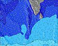 | 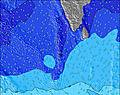 | 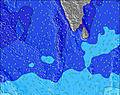 | 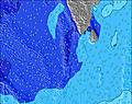 | 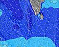 | 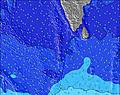 | ||||||||||||
Wave Height (m) Direction Period (s) | SSW 12 | SSE 8 | SSW 16 | SSE 9 | SSW 14 | SSW 14 | SSW 13 | SSE 9 | SSE 8 | SSE 8 | SSE 9 | SSE 9 | SSE 10 | SSE 9 | SSE 9 | SSE 9 | SSW 13 | SE 11 | SSW 14 |
Wave Graph | |||||||||||||||||||
113 | 113 | 223 | 154 | 183 | 220 | 151 | 168 | 160 | 194 | 212 | 232 | 264 | 193 | 193 | 138 | 227 | 334 | 346 | |
Wind (km/h) | |||||||||||||||||||
Wind State on-shore cross-onshore cross-shore cross-offshore off-shore glassy | cross | cross | cross-off | cross-off | glassy | cross-off | cross-off | cross-off | cross-off | cross-off | off | off | cross-off | off | cross-off | cross-off | cross-off | cross-off | cross-off |
High Tide | 4:57AM0.74m | 4:29PM0.81m | 5:46AM0.70m | 4:52PM0.73m | 6:44AM0.66m | 5:09PM0.65m | 8:10AM0.63m | 5:09PM0.58m | 10:12AM0.63m | 11:33AM0.68m | 9:58PM0.46m | ||||||||
Low Tide | 10:32PM0.14m | 10:23AM0.34m | 11:05PM0.16m | 10:59AM0.42m | 11:40PM0.19m | 11:42AM0.48m | 00:21AM0.22m | 12:57PM0.54m | 1:22AM0.25m | 3:01AM0.26m | 7:07PM0.44m | 4:34AM0.23m | |||||||
— | 6:01 | — | — | 6:01 | — | — | 6:01 | — | — | 6:01 | — | — | 6:01 | — | — | 6:01 | — | — | |
— | — | 6:22 | — | — | 6:22 | — | — | 6:22 | — | — | 6:22 | — | — | 6:22 | — | — | 6:22 | — | |
mm | — | — | — | — | — | — | — | — | — | — | — | — | — | — | — | — | — | — | — |
Temp °C | 28 | 28 | 28 | 28 | 27 | 28 | 28 | 28 | 28 | 28 | 27 | 28 | 28 | 28 | 28 | 28 | 28 | 28 | 28 |
Feels °C | 30 | 31 | 31 | 31 | 31 | 32 | 32 | 32 | 31 | 30 | 30 | 31 | 32 | 31 | 31 | 31 | 30 | 31 | 31 |
Swell 1 Height (m) Direction Period (s) | WNW 9 | WNW 9 | SSE 8 | SSE 9 | SSE 9 | SSE 8 | SSE 8 | SSE 9 | SSE 8 | SSE 8 | SSE 9 | SSE 9 | SSE 10 | SSE 9 | SSE 9 | SSE 9 | SE 9 | SE 11 | SE 10 |
201 | 143 | 113 | 154 | 127 | 103 | 101 | 168 | 160 | 194 | 212 | 232 | 264 | 193 | 193 | 138 | 186 | 334 | 290 | |
Swell 2 Height (m) Direction Period (s) | SSE 8 | SSE 8 | WNW 9 | WNW 8 | WNW 8 | SSW 14 | WNW 10 | WNW 9 | WNW 8 | WNW 8 | WNW 8 | SW 15 | SW 15 | SW 13 | SW 13 | SE 9 | SSW 13 | NW 10 | SSW 14 |
82 | 111 | 137 | 101 | 76 | 220 | 83 | 90 | 78 | 54 | 40 | 112 | 171 | 183 | 183 | 83 | 227 | 90 | 346 | |
Swell 3 Height (m) Direction Period (s) | SSW 12 | SSW 12 | SSW 16 | SSW 11 | SSW 14 | WNW 8 | SSW 13 | SSW 12 | SSW 12 | SSW 12 | SW 16 | WNW 8 | NW 7 | NW 7 | NNW 10 | SW 13 | NW 10 | SSW 14 | NW 10 |
113 | 113 | 223 | 73 | 183 | 75 | 151 | 59 | 82 | 54 | 124 | 33 | 27 | 25 | 41 | 136 | 98 | 165 | 127 | |
Wind waves Height (m) Direction Period (s) | — | — | — | — | — | — | — | — | — | — | — | — | — | — | — | — | — | — | SW 2 |
— | — | — | — | — | — | — | — | — | — | — | — | — | — | — | — | — | — | 1 | |
Nearest Offshore or Glassy | |||||||||||||||||||
Distance (km) | 7 | 7 | 0 | 0 | 0 | 0 | 0 | 0 | 0 | 0 | 0 | 0 | 0 | 0 | 0 | 0 | 0 | 0 | 0 |
Best forecast wave conditions in North Male Atoll | |||||||||||||||||||
Best forecast wave conditions in Maldives | |||||||||||||||||||
Header Global | |||||||||||||||||||
- Map Icons:
 Break
Break Live Wave Height (m)
 Live Wind Speed (km/h)
 Surf Rating (10 Max)
 Ocean Swells (m)
- Wind Speed (km/h)


FREE! Surf-Forecast.com widget for your website
The surf report / weather widget below is available to embed on third party websites free of charge and provides a summary of our Kadu surf forecast. Simply grab the html code snippet that we provide and paste it into your own site. You can choose your preferred language and metric/imperial units for the surf forecast feed to suit users of your site. Click here to get the code.
Information about the Kadu Surf forecast
The above surf forecast table for Kadu provides essential information for determining whether the surfing conditions will be good over the next 16 days. A general guide to surfing at Kadu can be found by selecting the local surf guide option on the grey menu. Our Kadu surf forecast is unique since it includes wave energy (power) that defines the real feel of the surf rather than just the height or the period. If you surf the same spot (Kadu) regularly then make a mental note of the wave energy from the surf forecast table each time you go. Very soon you may start to choose your surf days based on the wave energy alone combined with our forecast of favourable offshore wind conditions. Our star ratings will help here and of course you will also find the usual wave height and period predictions on our surf forecasts as well as a full break down of the swell components under our advanced users option (to reveal that, click the little Einstein character under the tide times).
Further information to help with frequently asked questions about our surf forecast for Kadu may be found under the help tab on the top menu and also by moving your mouse over the question marks on the surf forecast table itself. Please always bear in mind that the forecast is for near-shore open water and local factors at each surf break influence the actual breaking wave height, such as the beach / reef profile, water depths offshore and shelter.
Are you planning a holiday in North Male Atoll? If you are looking for accommodation near Kadu, camping, hotels and holiday cottages in North Male Atoll, consider staying in Male which is 34 km (21 miles) away.
 Nearest