

Surf Forecasts:

Douglas Point surf forecast from 2 Aug 2026:
- Best quality surf: Monday 10 Aug, 12AM (local time) - 18ft (5.5m), 18s period, WSW swell with cross-shore winds.
- Most powerful swell: Monday 10 Aug, 12AM (local time) - 18ft (5.5m), 18s period, WSW swell with 18,267 kJ wave energy.
- Next surfable swell (1★+): Wednesday 5 Aug, 6AM (local time) - 6ft (1.9m), 14s period with SW swell.
Best Forecast Surf Conditions for Douglas Point this week:
The surf forecast for Douglas Point over the next 16 days: The first swell (rated 1 star or higher) is forecast to arrive on Wednesday (Aug 05) at 6AM. The primary swell is predicted to be 1.9m and 14s period with a secondary swell of 1.2m and 19s. The wind is predicted to be cross-offshore as the swell arrives.
The most powerful waves expected at Douglas Point in the next 16 days are 5.5m 18s and forecast to arrive on Monday (Aug 10) at 12AM. Winds are predicted to be cross-shore at the time the swell arrives. The largest open ocean swell (not directed at the beach) is 2.5m 8s period and expected on Sunday (Aug 09) at 12AM.
| Wave Type | Time (ACST) & Date | Wave Height & Period |
|---|---|---|
| Next good surf (1 star+) | 6AM (Wed 5th Aug) | 6ft (1.9m) 14s |
| Best Surf | 12AM (Mon 10th Aug) | 18ft (5.5m) 18s |
| Most Powerful | 12AM (Mon 10th Aug) | 18ft (5.5m) 18s |
Table - best surf conditions forecast for Douglas Point over the next 16 days.
The Lowdown
Alright, Rusty here again. Let’s break it down in feet and miles.
The only spot in the game for the next 16 days is Douglas Point, a reef break. The first few days are a bust.
Monday the 3rd and Tuesday the 4th are a mess. We’ve got a 8ft to 13ft swell from the WSW, but the wind is a cross-shore at 22 mph, just tearing the surface up. The combined energy is moderate to strong (4294 to 6151), doesn’t matter; it’s lumpy.
Wednesday morning, the 5th, we get a break. The wind goes light cross-offshore from the WNW, and the swell drops to a clean 6ft from the SW, with a 14-second period. The energy is moderate (2404). For an intermediate surfer, this is a clean, fun window.
Thursday morning the 6th is a real gem. A clean 6ft SW swell, with a very long 16-second period, and the wind is pure offshore from the NNW at 12 mph. The energy is moderate (1867), but the conditions are pristine. A proper reef runner.
Friday the 7th is the big one. Clear skies, gentle offshore wind from the N at 9 mph. The swell is a solid 10ft from the SW, with a very long 17-second period. The combined energy is through the roof (8099). This is big, powerful, and clean. Water temps are about average for the season. For the experienced crew, this is the session of the week. The afternoon is just as good.
The weekend gets rough. Saturday the 8th has the same 10ft SW swell, but the wind is a fresh 22 mph offshore. It’s clean, but you’ll be fighting to get out. Sunday the 9th is a total washout: cross-shore wind and a messy 15ft W swell (7662 energy). Stay home.
Second week, things get huge. Monday the 10th sees a 18ft WSW swell with a 16-second period, and the energy is extreme (15015). The wind is okay, but the swell is predicted to be too big for the break. The 15th of August is another massive session: 23ft WSW swell, 19-second period, energy over 35,000. It’s an expert-only show, but it’s just too big.
The last standout is Monday morning the 17th. A 15ft SW swell, 15-second period, with a light cross-offshore breeze from the NE at 6 mph. The energy is very strong (8120), and the conditions are clean. A solid option for the pros.
The two true standouts to circle on your calendar are Friday the 7th and Monday the 17th. Everything else is either windy, too big, or messy. Crowds are a possibility at Douglas Point, so get there early.
Rusty, signing off.
Short Range ForecastModerate rain (total 10mm), heaviest on Sun night. Very mild (max 12°C on Sun night, min 10°C on Sun night). Winds decreasing (fresh winds from the WSW on Mon afternoon, light winds from the WNW by Wed morning). | Days 5-7 Weather SummaryLight rain (total 3mm), mostly falling on Thu afternoon. Very mild (max 16°C on Fri afternoon, min 9°C on Wed night). Winds increasing (light winds from the WNW on Thu night, strong winds from the N by Sat afternoon). | ||||||||||||||||||
Monday 3 | Tuesday 4 | Wednesday 5 | Thursday 6 | Friday 7 | Saturday 8 | ||||||||||||||
Night | AM | PM | Night | AM | PM | Night | AM | PM | Night | AM | PM | Night | AM | PM | Night | AM | PM | Night | |
Swell Height Map |  | 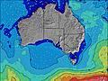 | 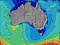 | 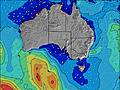 | 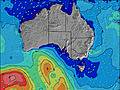 | 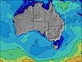 | 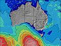 | ||||||||||||
Wave Height (m) Direction Period (s) | SW 15 | WSW 15 | WSW 14 | SW 12 | SW 12 | SW 11 | SW 10 | SW 14 | SW 13 | SW 16 | SW 16 | WSW 16 | SW 15 | SW 16 | SW 17 | SW 16 | SW 16 | SW 15 | SW 15 |
Wave Graph | |||||||||||||||||||
2562 | 2368 | 6151 | 4902 | 2977 | 2069 | 1111 | 1484 | 1102 | 865 | 1845 | 1953 | 2832 | 4306 | 5733 | 4314 | 3792 | 3307 | 2684 | |
Wind (km/h) | |||||||||||||||||||
Wind State on-shore cross-onshore cross-shore cross-offshore off-shore glassy | cross-off | cross | cross | cross-on | cross | cross-on | cross | cross-off | cross-off | off | off | cross-off | cross-off | off | off | off | off | off | off |
High Tide | 2:25AM0.83m | 2:46PM1.01m | 2:58AM0.86m | 2:55PM0.92m | 3:36AM0.88m | 2:54PM0.85m | 4:21AM0.87m | 2:36PM0.80m | 5:24AM0.84m | 1:42PM0.82m | 12:38PM0.90m | ||||||||
Low Tide | 8:18AM0.37m | 9:07PM0.41m | 8:50AM0.43m | 9:17PM0.36m | 9:21AM0.52m | 9:30PM0.31m | 9:47AM0.63m | 9:45PM0.26m | 9:57AM0.75m | 10:02PM0.23m | 10:22PM0.23m | ||||||||
— | 7:05 | — | — | 7:05 | — | — | 7:03 | — | — | 7:03 | — | — | 7:01 | — | — | 7:01 | — | — | |
— | — | 5:20 | — | — | 5:21 | — | — | 5:21 | — | — | 5:22 | — | — | 5:22 | — | — | 5:23 | — | |
mm | 7 | — | 1 | — | 1 | 1 | — | — | — | — | — | 1 | — | — | — | — | — | 2 | 11 |
Temp °C | 12 | 11 | 11 | 12 | 11 | 12 | 11 | 12 | 12 | 11 | 13 | 14 | 13 | 15 | 16 | 14 | 14 | 10 | 11 |
Feels °C | 6 | 3 | 3 | 5 | 5 | 6 | 7 | 7 | 8 | 7 | 8 | 11 | 11 | 12 | 12 | 8 | 5 | 1 | 3 |
Swell 1 Height (m) Direction Period (s) | SW 15 | WSW 15 | — | SW 17 | SW 12 | SW 21 | SW 10 | SW 14 | SW 13 | SW 16 | SW 16 | WSW 16 | SW 15 | SW 16 | SW 17 | SW 16 | SW 16 | SW 15 | SW 15 |
2562 | 2368 | — | 505 | 2977 | 154 | 1111 | 1484 | 1102 | 865 | 1845 | 1953 | 2832 | 4306 | 5733 | 4314 | 3792 | 3307 | 2684 | |
Swell 2 Height (m) Direction Period (s) | WSW 18 | SSW 14 | — | — | SW 16 | SW 21 | SW 20 | SW 19 | SW 18 | SW 13 | SSE 7 | WSW 20 | WSW 18 | SW 20 | SW 18 | — | — | WNW 8 | — |
768 | 886 | — | — | 90 | 109 | 660 | 920 | 710 | 464 | 10 | 485 | 997 | 1379 | 2366 | — | — | 81 | — | |
Swell 3 Height (m) Direction Period (s) | — | — | — | — | S 14 | S 13 | — | — | SSE 9 | SSE 8 | S 8 | SSE 8 | W 7 | SSE 8 | — | — | — | — | — |
— | — | — | — | 4 | 3 | — | — | 62 | 51 | 12 | 13 | 38 | 6 | — | — | — | — | — | |
Wind waves Height (m) Direction Period (s) | W 9 | W 9 | WSW 14 | SW 12 | — | SW 11 | — | — | — | — | — | — | — | — | — | N 4 | NNW 5 | NNW 7 | NW 8 |
1064 | 1040 | 6151 | 4902 | — | 2069 | — | — | — | — | — | — | — | — | — | 12 | 75 | 320 | 909 | |
Nearest Offshore or Glassy | |||||||||||||||||||
Distance (km) | 80 | 267 | 287 | 267 | 287 | 303 | 80 | 0 | 80 | 0 | 0 | 13 | 0 | 0 | 0 | 13 | 279 | 279 | 461 |
Best forecast wave conditions in South Australia - East Coast | |||||||||||||||||||
Best forecast wave conditions in Australia | |||||||||||||||||||
Header Global | |||||||||||||||||||
- Map Icons:
 Break
Break Live Wave Height (m)
 Live Wind Speed (km/h)
 Surf Rating (10 Max)
 Ocean Swells (m)
- Wind Speed (km/h)
Latest Updates


FREE! Surf-Forecast.com widget for your website
The surf report / weather widget below is available to embed on third party websites free of charge and provides a summary of our Douglas Point surf forecast. Simply grab the html code snippet that we provide and paste it into your own site. You can choose your preferred language and metric/imperial units for the surf forecast feed to suit users of your site. Click here to get the code.
Information about the Douglas Point Surf forecast
The above surf forecast table for Douglas Point provides essential information for determining whether the surfing conditions will be good over the next 16 days. A general guide to surfing at Douglas Point can be found by selecting the local surf guide option on the grey menu. Our Douglas Point surf forecast is unique since it includes wave energy (power) that defines the real feel of the surf rather than just the height or the period. If you surf the same spot (Douglas Point) regularly then make a mental note of the wave energy from the surf forecast table each time you go. Very soon you may start to choose your surf days based on the wave energy alone combined with our forecast of favourable offshore wind conditions. Our star ratings will help here and of course you will also find the usual wave height and period predictions on our surf forecasts as well as a full break down of the swell components under our advanced users option (to reveal that, click the little Einstein character under the tide times).
Further information to help with frequently asked questions about our surf forecast for Douglas Point may be found under the help tab on the top menu and also by moving your mouse over the question marks on the surf forecast table itself. Please always bear in mind that the forecast is for near-shore open water and local factors at each surf break influence the actual breaking wave height, such as the beach / reef profile, water depths offshore and shelter.
Douglas Point is 7 km (4 miles) from Allendale East. If you plan a holiday in South Australia - East Coast, look for hotels and other accommodation in Allendale East. Allendale East has rooms for a wide range of budgets as well as car hire and transport links.
 Nearest