

Surf Forecasts:

Chernobyl surf forecast from 3 Aug 2026:
- Best quality surf: Tuesday 4 Aug, 5AM (local time) - 2ft (0.6m), 8s period, E swell with cross-offshore winds.
- Most powerful swell: Friday 7 Aug, 5PM (local time) - 5ft (1.5m), 7s period, E swell with 217 kJ wave energy.
- Next surfable swell (1★+): Tuesday 4 Aug, 5AM (local time) - 2ft (0.6m), 8s period with E swell.
Best Forecast Surf Conditions for Chernobyl this week:
The surf forecast for Chernobyl over the next 16 days: The first swell (rated 1 star or higher) is forecast to arrive on Tuesday (Aug 04) at 5AM. The primary swell is predicted to be 0.6m and 8s period. The wind is predicted to be cross-offshore as the swell arrives.
The most powerful waves expected at Chernobyl in the next 16 days are 1.5m 7s and forecast to arrive on Friday (Aug 07) at 5PM. Winds are predicted to be onshore at the time the swell arrives. The largest open ocean swell (not directed at the beach) is 0.5m 6s period and expected on Friday (Aug 07) at 8PM.
| Wave Type | Time (EDT) & Date | Wave Height & Period |
|---|---|---|
| Next good surf (1 star+) | 5AM (Tue 4th Aug) | 2ft (0.6m) 8s |
| Best Surf | 5AM (Tue 4th Aug) | 2ft (0.6m) 8s |
| Most Powerful | 5PM (Fri 7th Aug) | 5ft (1.5m) 7s |
Table - best surf conditions forecast for Chernobyl over the next 16 days.
The Lowdown
Alright, this is Rusty. Let’s be straight with you. The next two weeks are going to be a real struggle for waves around here. The forecast is a long, flat, and messy stretch with very little to get excited about. We’re looking at a gap of several days with no real surf on offer to start.
The first glimmer of anything comes in on the morning of Monday, August 3rd, but even then it’s a tough call. The swell is tiny, only 2 ft coming from the east with a short period of 8 seconds. The combined energy is weak at 31. The wind is a cross-offshore from the southwest, which is okay, but the water is a bit colder than normal at 82°F, and it’s just labeled as “poor surf conditions.” It’s not worth paddling out for.
The pattern holds through the week. Tuesday morning, August 4th, sees a slightly bigger 2 ft from the east-southeast, but still with a short 8-second period. The wind is cross-off from the south-southwest, keeping it clean, but the combined energy is only 44. The file says “surfable waves but very ordinary conditions,” which is about as positive as it gets. Honestly, it’s still a flat day.
From Wednesday, August 5th, right through to the afternoon of Monday, August 17th, the story is the same: tiny swell, mostly under 2 ft, onshore or cross-onshore winds, and short periods. The combined energy stays below 100 for most of that time, indicating very weak wave energy. It’s a cruel, flat run. There is a brief spike on Friday, August 7th, with the swell hitting 5 ft to 5 ft from the east, and the energy jumping to 172 and 227, but it’s all onshore wind from the east at 12-15 mph, making it a complete mess. Not worth a look.
The only real standout, and I mean the *only* one, is a very brief moment on the morning of Monday, August 17th. The wind turns offshore from the west-northwest, blowing at 6 mph, which will clean things right up. The swell is still tiny at 1 ft from the east-southeast, with a period of 8 seconds and a combined energy of only 22. It’s not going to be a wave of consequence, but if you’re desperate for a clean, small-wave session on a longboard, that’s your window. For a beginner, the tiny size is actually fine, but the lack of power is the real issue.
To be clear, the best option on offer is Chernobyl, and it’s a bleak pick. It’s a beginner break that is fairly consistent, but the crowds are often there. The optimum swell direction is north-northeast, and we’re getting nothing but east and east-southeast. It’s exposed, but it’s not doing us any favors.
The break is a beginner spot, and if the swell were over 5 ft it might be too much, but that's not an issue here. The short periods (under 8 seconds) mean the waves will be weak and crumbly. The long period swells (over 15 seconds) are not forecast, so no caveats there.
So, there you have it. A long, flat period with a single, tiny window of clean conditions. Not a good outlook. If you’re a kite surfer, the high winds on Friday, August 7th, with that 5 ft messy swell, might look tempting, but for paddle surfing, it’s a write-off. It tends not to stay poor for long around here, so keep an eye on the forecasts.
Rusty.
Short Range ForecastHeavy rain (total 26mm), heaviest during Mon night. Warm (max 32°C on Mon afternoon, min 24°C on Mon night). Wind will be generally light. | Days 4-6 Weather SummaryModerate rain (total 12mm), heaviest on Thu night. Warm (max 28°C on Thu morning, min 27°C on Thu morning). Wind will be generally light. | ||||||||||||||||||||
Monday 3 | Tuesday 4 | Wednesday 5 | Thursday 6 | Friday 7 | Saturday 8 | Sunday 9 | |||||||||||||||
AM | PM | Night | AM | PM | Night | AM | PM | Night | AM | PM | Night | AM | PM | Night | AM | PM | Night | AM | PM | Night | |
Swell Height Map |  |  |  | 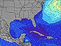 | 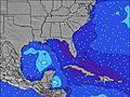 | 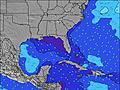 | 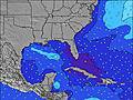 | ||||||||||||||
Wave Height (m) Direction Period (s) | E 8 | E 8 | E 8 | ESE 8 | E 8 | ESE 7 | E 7 | E 7 | E 7 | ESE 5 | ESE 5 | E 6 | E 7 | E 7 | E 8 | E 8 | E 8 | E 8 | E 8 | E 7 | E 7 |
Wave Graph | |||||||||||||||||||||
30 | 29 | 29 | 44 | 41 | 43 | 28 | 28 | 16 | 42 | 36 | 72 | 168 | 217 | 181 | 185 | 153 | 119 | 89 | 51 | 51 | |
Wind (km/h) | |||||||||||||||||||||
Wind State on-shore cross-onshore cross-shore cross-offshore off-shore glassy | cross-off | cross-on | cross-off | cross-off | on | glassy | cross-on | on | on | on | on | on | on | on | on | cross-on | on | cross-on | on | on | cross-on |
High Tide | 11:58AM0.35m | 00:07AM0.28m | 12:55PM0.36m | 1:01AM0.25m | 1:55PM0.37m | 2:00AM0.23m | 2:59PM0.39m | 3:05AM0.22m | 4:02PM0.41m | 4:10AM0.23m | 5:02PM0.44m | 5:13AM0.24m | 5:58PM0.47m | ||||||||
Low Tide | 6:09PM-0.27m | 6:23AM-0.37m | 7:09PM-0.26m | 7:17AM-0.37m | 8:14PM-0.24m | 8:15AM-0.37m | 9:21PM-0.25m | 9:17AM-0.38m | 10:26PM-0.27m | 10:19AM-0.39m | 11:27PM-0.29m | 11:20AM-0.41m | 00:22AM-0.33m | ||||||||
6:45 | — | — | 6:46 | — | — | 6:46 | — | — | 6:47 | — | — | 6:47 | — | — | 6:48 | — | — | 6:48 | — | — | |
— | 8:09 | — | — | 8:08 | — | — | 8:07 | — | — | 8:07 | — | — | 8:07 | — | — | 8:06 | — | — | 8:05 | — | |
mm | — | 2 | 19 | — | — | 2 | 1 | 1 | 1 | 1 | — | 6 | — | 2 | 1 | — | — | 2 | — | — | — |
Temp °C | 29 | 32 | 24 | 28 | 29 | 29 | 28 | 28 | 28 | 28 | 28 | 28 | 28 | 28 | 27 | 28 | 28 | 28 | 28 | 28 | 28 |
Feels °C | 32 | 33 | 28 | 31 | 32 | 31 | 31 | 32 | 31 | 30 | 30 | 31 | 29 | 29 | 29 | 31 | 30 | 31 | 31 | 30 | 32 |
Swell 1 Height (m) Direction Period (s) | E 8 | E 8 | E 8 | ESE 8 | E 8 | ESE 7 | E 7 | E 7 | E 7 | ESE 5 | E 7 | E 9 | NE 10 | ENE 10 | E 8 | E 8 | E 8 | E 8 | E 8 | E 7 | E 7 |
30 | 29 | 29 | 44 | 41 | 43 | 28 | 28 | 16 | 42 | 9 | 2 | 4 | 10 | 181 | 185 | 153 | 119 | 89 | 51 | 51 | |
Swell 2 Height (m) Direction Period (s) | — | — | SSE 4 | SSE 4 | SSE 4 | — | — | E 9 | — | E 10 | NE 10 | E 11 | — | — | SSE 5 | NE 9 | NE 9 | NE 9 | SSE 5 | SSE 4 | ENE 9 |
— | — | 6 | 2 | 1 | — | — | 2 | — | 2 | 4 | 2 | — | — | 11 | 14 | 13 | 13 | 8 | 2 | 8 | |
Swell 3 Height (m) Direction Period (s) | — | E 10 | — | S 4 | — | — | — | — | — | — | NE 10 | — | — | — | ENE 10 | — | NE 9 | — | NE 9 | ENE 9 | S 5 |
— | 2 | — | 1 | — | — | — | — | — | — | 4 | — | — | — | 9 | — | 13 | — | 14 | 8 | 2 | |
Wind waves Height (m) Direction Period (s) | S 4 | SSE 4 | — | — | — | SSE 3 | — | — | ESE 4 | — | ESE 5 | E 6 | E 7 | E 7 | — | SSE 5 | SSE 5 | SSE 5 | — | — | SSE 4 |
1 | 1 | — | — | — | 2 | — | — | 13 | — | 36 | 72 | 168 | 217 | — | 8 | 9 | 5 | — | — | 2 | |
Nearest Offshore or Glassy | |||||||||||||||||||||
Distance (km) | 214 | 65 | 1004 | 0 | 125 | 0 | 214 | 150 | 1333 | 233 | 1820 | 1340 | 1094 | 454 | 709 | 619 | 619 | 91 | 125 | 1303 | 125 |
Best forecast wave conditions in North Florida | |||||||||||||||||||||
Best forecast wave conditions in United States | |||||||||||||||||||||
Header Global | |||||||||||||||||||||
- Map Icons:
 Break
Break Live Wave Height (m)
 Live Wind Speed (km/h)
 Surf Rating (10 Max)
 Ocean Swells (m)
- Wind Speed (km/h)
Latest Updates


FREE! Surf-Forecast.com widget for your website
The surf report / weather widget below is available to embed on third party websites free of charge and provides a summary of our Chernobyl surf forecast. Simply grab the html code snippet that we provide and paste it into your own site. You can choose your preferred language and metric/imperial units for the surf forecast feed to suit users of your site. Click here to get the code.
Information about the Chernobyl Surf forecast
The above surf forecast table for Chernobyl provides essential information for determining whether the surfing conditions will be good over the next 16 days. A general guide to surfing at Chernobyl can be found by selecting the local surf guide option on the grey menu. Our Chernobyl surf forecast is unique since it includes wave energy (power) that defines the real feel of the surf rather than just the height or the period. If you surf the same spot (Chernobyl) regularly then make a mental note of the wave energy from the surf forecast table each time you go. Very soon you may start to choose your surf days based on the wave energy alone combined with our forecast of favourable offshore wind conditions. Our star ratings will help here and of course you will also find the usual wave height and period predictions on our surf forecasts as well as a full break down of the swell components under our advanced users option (to reveal that, click the little Einstein character under the tide times).
Further information to help with frequently asked questions about our surf forecast for Chernobyl may be found under the help tab on the top menu and also by moving your mouse over the question marks on the surf forecast table itself. Please always bear in mind that the forecast is for near-shore open water and local factors at each surf break influence the actual breaking wave height, such as the beach / reef profile, water depths offshore and shelter.
Chernobyl is 9 km (6 miles) from the city of Sebastian. If you plan a vacation in North Florida, look for hotels and other accommodation in Sebastian. Sebastian has rooms for a wide range of budgets as well as car hire and transport links.
 Nearest