

Surf Forecasts:

Boiler Bay surf forecast from 2 Aug 2026:
- Best quality surf: Thursday 6 Aug, 5AM (local time) - 4.5ft (1.4m), 8s period, NW swell with glassy winds.
- Most powerful swell: Sunday 2 Aug, 5PM (local time) - 6ft (1.8m), 9s period, WNW swell with 535 kJ wave energy.
- Next surfable swell (1★+): Thursday 6 Aug, 5AM (local time) - 4.5ft (1.4m), 8s period with NW swell.
Best Forecast Surf Conditions for Boiler Bay this week:
The surf forecast for Boiler Bay over the next 16 days: The first swell (rated 1 star or higher) is forecast to arrive on Thursday (Aug 06) at 5AM. The primary swell is predicted to be 1.4m and 8s period with a secondary swell of 0.4m and 14s. The wind is predicted to be glassy as the swell arrives.
The most powerful waves expected at Boiler Bay in the next 16 days are 1.8m 9s and forecast to arrive on Sunday (Aug 02) at 5PM. Winds are predicted to be onshore at the time the swell arrives. The largest open ocean swell (not directed at the beach) is 2.1m 7s period and expected on Monday (Aug 03) at 11PM.
| Wave Type | Time (PDT) & Date | Wave Height & Period |
|---|---|---|
| Next good surf (1 star+) | 5AM (Thu 6th Aug) | 4.5ft (1.4m) 8s |
| Best Surf | 5AM (Thu 6th Aug) | 4.5ft (1.4m) 8s |
| Most Powerful | 5PM (Sun 2nd Aug) | 6ft (1.8m) 9s |
Table - best surf conditions forecast for Boiler Bay over the next 16 days.
The Lowdown
G’day, it’s Rusty here.
Honestly, looking at the next couple weeks for our stretch, I gotta level with you: it’s pretty grim out there for a proper paddle. We’ve got a solid stretch of poor surf conditions, with the wind and the swell not playing nice at all. The water’s sitting at about 57°, which is a touch cooler than normal for this time of year—nothing crazy, but you’ll feel it.
The first real chance of anything even close to surfable is Thursday morning, the 6th. We’re looking at a junky 4ft of swell from the NW with a short 8-second period. The energy’s weak, only 270 in the combined reading. It’s a marginal call at best, with a light cross-onshore wind. Not exactly firing, but it’s the first thing on the board.
Then we hit a proper dead spell. From Friday the 7th through Tuesday the 11th, it’s mostly tiny, weak swell and onshore winds, with a few bigger, longer-period pulses (around 15-16 seconds) but they’re small—like 1ft to 2ft—and pretty much useless for this spot. The wind’s blowing on it, making it messy. You’re better off finding something else to do for a few days.
The next thing that even gets a pulse is Wednesday the 12th. We see a bit of a bump in the energy—around 523 in the morning—with 5ft of NW swell, but the wind is still cross-onshore, and the conditions are just marginal. It’s not clean, but it’s the best we’ve seen in a while. The period is still short at 8 seconds, so it’ll be a bit weak and crumbly.
After that, it’s another letdown for the rest of the week. More small, long-period swells and onshore winds on Thursday and Friday. By Saturday the 15th and Sunday the 16th, there’s a little more size in the water—5ft to 5ft—but the period drops back to 8 seconds, and the wind is just ruining it. The energy readings are moderate (up to 793 on Sunday afternoon), but it’s all for nothing with that wind chop.
The only other glimmer is Monday the 17th, but again, it’s a marginal morning with a cross-onshore breeze and a short-period swell. It’s not going to be good.
So, where’s the standout? Honestly, there isn’t one. The pick of the entire run is probably Wednesday the 12th morning if you’re desperate—it’s the first time the energy climbs into the moderate range (523), and the wind is a lighter 3 mph, which is the calmest we’ll see. But it’s still cross-onshore. For a spot like Boiler Bay, a reef break that needs a bit of direction, this whole NW swell with a cross-on wind is just a mess. The swell direction never gets close to the SW optimum we’d love to see.
I wouldn’t recommend a beginner anywhere near this; when it does get over 5ft, it’s already pushing it for most. And when the wind’s on it like this, it’s just a washing machine. Honestly, for the next couple of weeks, this setup looks way more interesting for a kite surfer than a paddle surfer. We’re in a proper dry spell, but these things don’t last forever. Forecasts can change. Keep your board ready, but don’t hold your breath.
Rusty, out.
Short Range ForecastMostly dry. Warm (max 22°C on Tue morning, min 11°C on Sun night). Mainly fresh winds. | Days 4-6 Weather SummaryMostly dry. Warm (max 21°C on Wed morning, min 14°C on Wed night). Wind will be generally light. | ||||||||||||||||||||
Sunday 2 | Monday 3 | Tuesday 4 | Wednesday 5 | Thursday 6 | Friday 7 | Saturday 8 | |||||||||||||||
AM | PM | Night | AM | PM | Night | AM | PM | Night | AM | PM | Night | AM | PM | Night | AM | PM | Night | AM | PM | Night | |
Swell Height Map | 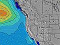 |  | 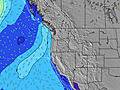 | 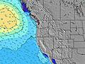 | 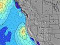 | 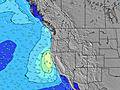 | 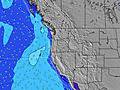 | ||||||||||||||
Wave Height (m) Direction Period (s) | WNW 9 | WNW 9 | NW 8 | NW 8 | NW 7 | NW 7 | NW 7 | NW 7 | NW 8 | NW 8 | NW 8 | NW 8 | NW 8 | NW 8 | NW 8 | NW 7 | SW 18 | SW 18 | SW 16 | NNW 6 | SW 17 |
Wave Graph | |||||||||||||||||||||
436 | 535 | 423 | 270 | 296 | 223 | 277 | 331 | 481 | 308 | 341 | 264 | 210 | 270 | 229 | 151 | 57 | 56 | 69 | 158 | 76 | |
Wind (km/h) | |||||||||||||||||||||
Wind State on-shore cross-onshore cross-shore cross-offshore off-shore glassy | cross-on | on | on | on | on | on | on | on | on | cross-on | cross-on | on | cross-on | cross-on | on | cross-on | on | on | on | on | on |
High Tide | 3:36PM2.30m | 3:25AM2.06m | 4:08PM2.36m | 4:19AM1.86m | 4:43PM2.41m | 5:26AM1.67m | 5:26PM2.45m | 6:51AM1.54m | 6:18PM2.47m | 8:29AM1.53m | 7:22PM2.50m | 9:55AM1.64m | 8:33PM2.57m | ||||||||
Low Tide | 9:06AM-0.06m | 9:37PM0.50m | 9:37AM0.15m | 10:29PM0.40m | 10:12AM0.40m | 11:27PM0.30m | 10:51AM0.66m | 00:34AM0.18m | 11:42AM0.91m | 1:48AM0.04m | 12:51PM1.10m | 3:00AM-0.14m | 2:16PM1.17m | 4:05AM-0.34m | |||||||
6:01 | — | — | 6:03 | — | — | 6:05 | — | — | 6:05 | — | — | 6:07 | — | — | 6:07 | — | — | 6:09 | — | — | |
— | 8:40 | — | — | 8:39 | — | — | 8:37 | — | — | 8:37 | — | — | 8:36 | — | — | 8:34 | — | — | 8:32 | — | |
mm | — | — | — | — | — | — | — | — | — | — | — | — | — | — | — | — | — | — | — | — | — |
Temp °C | 17 | 17 | 15 | 18 | 19 | 16 | 22 | 22 | 17 | 21 | 21 | 17 | 19 | 19 | 15 | 17 | 18 | 16 | 18 | 18 | 15 |
Feels °C | 14 | 13 | 11 | 15 | 14 | 13 | 20 | 19 | 14 | 20 | 19 | 16 | 19 | 18 | 14 | 15 | 15 | 13 | 15 | 14 | 11 |
Swell 1 Height (m) Direction Period (s) | WNW 9 | SW 13 | SW 13 | SW 13 | SW 13 | NW 7 | NW 7 | SW 16 | SW 15 | NW 8 | NW 8 | NW 8 | NW 8 | SW 13 | NW 8 | SW 13 | SW 13 | WNW 12 | WNW 11 | WNW 11 | WNW 10 |
436 | 63 | 62 | 27 | 27 | 223 | 277 | 63 | 56 | 308 | 341 | 264 | 210 | 63 | 229 | 60 | 57 | 46 | 47 | 45 | 63 | |
Swell 2 Height (m) Direction Period (s) | SW 14 | SW 18 | WSW 18 | WSW 18 | WSW 17 | WSW 16 | WSW 16 | SSW 12 | SW 12 | SW 15 | SW 14 | SW 14 | SW 14 | WSW 19 | SW 13 | WSW 18 | SW 18 | SW 13 | SW 12 | SW 13 | SW 17 |
64 | 13 | 31 | 30 | 28 | 25 | 25 | 14 | 6 | 54 | 53 | 50 | 48 | 37 | 61 | 31 | 50 | 56 | 54 | 41 | 76 | |
Swell 3 Height (m) Direction Period (s) | SW 19 | — | — | — | — | SW 13 | SW 12 | — | SW 12 | SSW 12 | W 21 | SW 11 | SSW 11 | W 16 | W 13 | W 15 | WNW 12 | SW 18 | SW 16 | SW 16 | SW 12 |
15 | — | — | — | — | 26 | 24 | — | 6 | 14 | 9 | 5 | 12 | 5 | 13 | 17 | 14 | 49 | 69 | 68 | 22 | |
Wind waves Height (m) Direction Period (s) | — | WNW 9 | NW 8 | NW 8 | NW 7 | N 7 | — | NW 7 | NW 8 | — | — | — | — | NW 8 | — | NW 7 | NNW 7 | NNW 7 | NNW 7 | NNW 6 | NNW 6 |
— | 535 | 423 | 270 | 296 | 168 | — | 331 | 481 | — | — | — | — | 270 | — | 151 | 264 | 250 | 175 | 158 | 150 | |
Nearest Offshore or Glassy | |||||||||||||||||||||
Distance (km) | 374 | 1215 | 10 | 225 | 396 | 10 | 103 | 342 | 11 | 160 | 282 | 103 | 230 | 1228 | 103 | 342 | 389 | 10 | 396 | 577 | 326 |
Best forecast wave conditions in North Oregon | |||||||||||||||||||||
Best forecast wave conditions in United States | |||||||||||||||||||||
Header Global | |||||||||||||||||||||
- Map Icons:
 Break
Break Live Wave Height (m)
 Live Wind Speed (km/h)
 Surf Rating (10 Max)
 Ocean Swells (m)
- Wind Speed (km/h)
Latest Updates


FREE! Surf-Forecast.com widget for your website
The surf report / weather widget below is available to embed on third party websites free of charge and provides a summary of our Boiler Bay surf forecast. Simply grab the html code snippet that we provide and paste it into your own site. You can choose your preferred language and metric/imperial units for the surf forecast feed to suit users of your site. Click here to get the code.
Information about the Boiler Bay Surf forecast
The above surf forecast table for Boiler Bay provides essential information for determining whether the surfing conditions will be good over the next 16 days. A general guide to surfing at Boiler Bay can be found by selecting the local surf guide option on the grey menu. Our Boiler Bay surf forecast is unique since it includes wave energy (power) that defines the real feel of the surf rather than just the height or the period. If you surf the same spot (Boiler Bay) regularly then make a mental note of the wave energy from the surf forecast table each time you go. Very soon you may start to choose your surf days based on the wave energy alone combined with our forecast of favourable offshore wind conditions. Our star ratings will help here and of course you will also find the usual wave height and period predictions on our surf forecasts as well as a full break down of the swell components under our advanced users option (to reveal that, click the little Einstein character under the tide times).
Further information to help with frequently asked questions about our surf forecast for Boiler Bay may be found under the help tab on the top menu and also by moving your mouse over the question marks on the surf forecast table itself. Please always bear in mind that the forecast is for near-shore open water and local factors at each surf break influence the actual breaking wave height, such as the beach / reef profile, water depths offshore and shelter.
Boiler Bay is 70 km (43 miles) from Corvallis. If you plan a vacation in North Oregon, look for hotels and other accommodation in Corvallis. Corvallis has rooms for a wide range of budgets as well as car hire and transport links.
 Nearest