

Surf Forecasts:

San Juan surf forecast from 3 Aug 2026:
- Most powerful swell: Thursday 6 Aug, 1PM (local time) - 8ft (2.4m), 8s period, NNE swell with 714 kJ wave energy.
Best Forecast Surf Conditions for San Juan this week:
The most powerful waves expected at San Juan in the next 16 days are 2.4m 8s and forecast to arrive on Thursday (Aug 06) at 1PM. Winds are predicted to be onshore at the time the swell arrives.
| Wave Type | Time (WEST) & Date | Wave Height & Period |
|---|---|---|
| Next good surf (1 star+) | - | - |
| Best Surf | - | - |
| Most Powerful | 1PM (Thu 6th Aug) | 8ft (2.4m) 8s |
Table - best surf conditions forecast for San Juan over the next 16 days.
The Lowdown
Alright folks, Rusty here. Let’s have a look at what’s coming up for San Juan. It’s a reef setup, expert-only, and it’s consistent, but we’re in for a rough stretch.
Right out of the gate, the news ain’t great. The whole 16-day window is looking pretty grim. We’ve got a lot of onshore wind, mainly from the NNE and N, blowing at 15 to 25 mph, and that’s making a mess of things. The swell is coming from the NNE and NE, which is okay, but the period is short – only 7 to 9 seconds – so it’s weak, wind-driven chop. The wave energy is moderate at best, sitting around 285 on Monday morning, and it just stays poor. We’re talking about a solid week of “poor surf conditions” with no score for any session. The winds are a constant moderate to fresh breeze, and that’s just not going to clean up the reef.
The first few days, from August 3rd through the 5th, you’re looking at 5ft to 7ft of messy, short-period swell, blown out by onshore winds. The combined energy climbs from 285 to 495, but it’s all junk. The water temp is about average for the time of year, so no surprises there. A surfer’s best bet is to stay home.
We get a bit of a bump in size from August 6th to the 8th, with swell heights hitting 8ft on Thursday morning, and the energy jumps to 754 on Thursday morning. But that’s a lot of power for a short-period swell, and with onshore-to-cross-onshore winds still blowing, it’s just going to be a washing machine. For a reef break that’s already expert-only, this is a no-go for anyone. It’s too big and messy for a paddle, and honestly, with that wind and chop, it looks more interesting for a kite session than a surf.
The second week, from August 9th onward, the swell drops back to 5ft to 3.5ft, but the wind stays stubbornly onshore from the N and NNE. The energy drops into the 200s and 100s by the end, meaning weak, weak waves. The period never gets above 9 seconds, so there’s no real groundswell to save us. The final session on August 18th has a swell of 3ft with a 9-second period, but the wind is a strong breeze at 25 mph. It’s a total write-off.
There is no standout day here. Not a single one. The best you could hope for is a tiny window on the 17th or 18th where the period stretches to 9 seconds, but the swell is too small and the wind is still on. Save your energy, lads. This is a flat spell for the reef.
Short Range ForecastMostly dry. Warm (max 23°C on Sun night, min 21°C on Sun night). Mainly fresh winds. | Days 4-6 Weather SummaryMostly dry. Warm (max 23°C on Sat afternoon, min 20°C on Thu night). Mainly strong winds. | ||||||||||||||||||||
Monday 3 | Tuesday 4 | Wednesday 5 | Thursday 6 | Friday 7 | Saturday 8 | Sunday 9 | |||||||||||||||
AM | PM | Night | AM | PM | Night | AM | PM | Night | AM | PM | Night | AM | PM | Night | AM | PM | Night | AM | PM | Night | |
Swell Height Map |  |  |  | 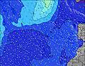 | 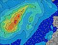 | 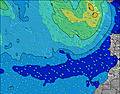 | 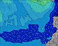 | ||||||||||||||
Wave Height (m) Direction Period (s) | NNE 7 | NNE 7 | NNE 6 | NE 7 | NE 7 | NNE 6 | NE 7 | NE 8 | NE 7 | NNE 8 | NNE 8 | NNE 8 | NNE 8 | NNE 8 | NNE 8 | NNE 8 | NNE 8 | N 7 | NNE 7 | NNE 7 | NNE 6 |
Wave Graph | |||||||||||||||||||||
224 | 165 | 209 | 330 | 227 | 253 | 456 | 407 | 452 | 714 | 541 | 464 | 520 | 485 | 473 | 485 | 395 | 311 | 254 | 212 | 156 | |
Wind (km/h) | |||||||||||||||||||||
Wind State on-shore cross-onshore cross-shore cross-offshore off-shore glassy | on | on | on | on | on | on | on | on | on | on | on | cross-on | on | cross-on | on | on | cross-on | cross-on | on | cross-on | on |
High Tide | 5:04AM2.14m | 5:18PM2.28m | 5:43AM2.07m | 5:59PM2.16m | 6:30AM1.98m | 6:50PM2.01m | 7:28AM1.89m | 7:59PM1.87m | 8:45AM1.84m | 9:27PM1.81m | 10:13AM1.88m | 10:57PM1.87m | 11:31AM2.04m | 00:09AM2.01m | |||||||
Low Tide | 11:01AM0.36m | 11:30PM0.32m | 11:41AM0.44m | 00:13AM0.42m | 12:30PM0.55m | 1:05AM0.54m | 1:34PM0.66m | 2:15AM0.65m | 3:01PM0.71m | 3:43AM0.69m | 4:36PM0.63m | 5:08AM0.61m | 5:54PM0.45m | ||||||||
7:15 | — | — | 7:16 | — | — | 7:16 | — | — | 7:16 | — | — | 7:16 | — | — | 7:18 | — | — | 7:18 | — | — | |
— | 8:45 | — | — | 8:44 | — | — | 8:43 | — | — | 8:42 | — | — | 8:40 | — | — | 8:40 | — | — | 8:39 | — | |
mm | — | — | — | — | — | — | — | — | — | — | — | — | — | — | — | — | — | — | — | — | — |
Temp °C | 23 | 23 | 21 | 23 | 23 | 21 | 22 | 22 | 21 | 21 | 22 | 20 | 22 | 22 | 21 | 22 | 23 | 21 | 22 | 23 | 21 |
Feels °C | 21 | 21 | 18 | 20 | 21 | 18 | 19 | 19 | 18 | 18 | 20 | 17 | 19 | 20 | 19 | 20 | 20 | 19 | 20 | 21 | 19 |
Swell 1 Height (m) Direction Period (s) | WNW 9 | WNW 9 | WNW 9 | WNW 9 | WNW 9 | WNW 8 | NW 8 | WNW 11 | WNW 10 | WNW 10 | WNW 10 | WNW 9 | WNW 9 | WNW 9 | WNW 9 | WNW 9 | NW 8 | NW 8 | NW 8 | NW 8 | NW 8 |
47 | 32 | 33 | 32 | 29 | 48 | 17 | 64 | 57 | 37 | 36 | 34 | 32 | 32 | 31 | 30 | 18 | 17 | 17 | 15 | 14 | |
Swell 2 Height (m) Direction Period (s) | N 9 | N 9 | N 8 | — | WNW 11 | — | WNW 10 | NNW 12 | NNW 11 | N 12 | N 12 | N 11 | W 9 | W 9 | — | — | — | — | N 10 | WNW 8 | N 12 |
14 | 13 | 12 | — | 12 | — | 20 | 14 | 40 | 3 | 3 | 9 | 2 | 2 | — | — | — | — | 18 | 6 | 3 | |
Swell 3 Height (m) Direction Period (s) | — | — | — | — | W 11 | — | N 11 | N 11 | — | — | — | — | — | — | — | — | — | — | — | — | — |
— | — | — | — | 2 | — | 2 | 2 | — | — | — | — | — | — | — | — | — | — | — | — | — | |
Wind waves Height (m) Direction Period (s) | NNE 7 | NNE 7 | NNE 6 | NE 7 | NE 7 | NNE 6 | NE 7 | NE 8 | NE 7 | NNE 8 | NNE 8 | NNE 8 | NNE 8 | NNE 8 | NNE 8 | NNE 8 | NNE 8 | N 7 | NNE 7 | NNE 7 | NNE 6 |
224 | 165 | 209 | 330 | 227 | 253 | 456 | 407 | 452 | 714 | 541 | 464 | 520 | 485 | 473 | 485 | 395 | 311 | 254 | 212 | 156 | |
Nearest Offshore or Glassy | |||||||||||||||||||||
Distance (km) | 38 | 38 | 38 | 259 | 38 | 276 | 259 | 259 | 259 | 259 | 259 | 259 | 231 | 231 | 392 | 331 | 259 | 392 | 38 | 259 | 38 |
Best forecast wave conditions in Lanzarote | |||||||||||||||||||||
Best forecast wave conditions in Spain (Africa) | |||||||||||||||||||||
Header Global | |||||||||||||||||||||
- Map Icons:
 Break
Break Live Wave Height (m)
 Live Wind Speed (km/h)
 Surf Rating (10 Max)
 Ocean Swells (m)
- Wind Speed (km/h)
Latest Updates


FREE! Surf-Forecast.com widget for your website
The surf report / weather widget below is available to embed on third party websites free of charge and provides a summary of our San Juan surf forecast. Simply grab the html code snippet that we provide and paste it into your own site. You can choose your preferred language and metric/imperial units for the surf forecast feed to suit users of your site. Click here to get the code.
Information about the San Juan Surf forecast
The above surf forecast table for San Juan provides essential information for determining whether the surfing conditions will be good over the next 16 days. A general guide to surfing at San Juan can be found by selecting the local surf guide option on the grey menu. Our San Juan surf forecast is unique since it includes wave energy (power) that defines the real feel of the surf rather than just the height or the period. If you surf the same spot (San Juan) regularly then make a mental note of the wave energy from the surf forecast table each time you go. Very soon you may start to choose your surf days based on the wave energy alone combined with our forecast of favourable offshore wind conditions. Our star ratings will help here and of course you will also find the usual wave height and period predictions on our surf forecasts as well as a full break down of the swell components under our advanced users option (to reveal that, click the little Einstein character under the tide times).
Further information to help with frequently asked questions about our surf forecast for San Juan may be found under the help tab on the top menu and also by moving your mouse over the question marks on the surf forecast table itself. Please always bear in mind that the forecast is for near-shore open water and local factors at each surf break influence the actual breaking wave height, such as the beach / reef profile, water depths offshore and shelter.
San Juan is 8 km (5 miles) from Teguise. If you plan a holiday in Lanzarote, look for hotels and other accommodation in Teguise. Teguise has rooms for a wide range of budgets as well as car hire and transport links.
 Nearest