

Surf Forecasts:

Kellys Beach surf forecast from 24 Jul 2026:
- Best quality surf: Friday 24 Jul, 5AM (local time) - 11ft (3.5m), 11s period, SW swell with cross-offshore winds.
- Most powerful swell: Friday 24 Jul, 2PM (local time) - 10ft (3.0m), 16s period, SSW swell with 4,129 kJ wave energy.
- Next surfable swell (1★+): Friday 24 Jul, 5AM (local time) - 11ft (3.5m), 11s period with SW swell.
Best Forecast Surf Conditions for Kellys Beach this week:
The surf forecast for Kellys Beach over the next 16 days: The first swell (rated 1 star or higher) is forecast to arrive on Friday (Jul 24) at 5AM. The primary swell is predicted to be 3.5m and 11s period with a secondary swell of 1.6m and 12s. Another secondary swell of 1.4m and 7s is also forecast. The wind is predicted to be cross-offshore as the swell arrives.
The most powerful waves expected at Kellys Beach in the next 16 days are 3.0m 16s and forecast to arrive on Friday (Jul 24) at 2PM. Winds are predicted to be cross-shore at the time the swell arrives. The largest open ocean swell (not directed at the beach) is 3.0m 9s period and expected on Friday (Jul 31) at 2AM.
| Wave Type | Time (SAST) & Date | Wave Height & Period |
|---|---|---|
| Next good surf (1 star+) | 5AM (Fri 24th Jul) | 11ft (3.5m) 11s |
| Best Surf | 5AM (Fri 24th Jul) | 11ft (3.5m) 11s |
| Most Powerful | 2PM (Fri 24th Jul) | 10ft (3.0m) 16s |
Table - best surf conditions forecast for Kellys Beach over the next 16 days.
The Lowdown
Alright folks, Rusty here. Let's take a look at what's on the menu for the next couple of weeks.
First up, we’ve got a bit of a wait on our hands. The early part of the forecast is a mess, so don't bother paddling out just yet. The real action, the stuff worth circling on the calendar, is a solid week and a half away.
Kellys Beach is our only option, and it's a real mixed bag. The water is running at 64°, which is a solid 4° colder than normal for this time of year, so you’ll be needing a thick wetsuit.
The one standout window is Friday, the 24th of July, in the morning. Now, this is a big one. We’re looking at a 10ft SSW groundswell rolling in with a very long period of 16 seconds. The combined energy is absolutely pumping at 4931, which is some serious juice. The wind is a light SW cross-off at 9 mph, so the faces are going to be clean. But here’s the kicker, and I gotta be straight with you: at 10ft, this is not for the faint of heart. This is a big, powerful wave. It's an exposed beginner-friendly break, but at this size, it's experts-only. The long period also means it might be a bit straight at the beach, but the energy is undeniable.
After that, the swell hangs around, but the wind gets messy. Saturday morning, the 25th of July, is worth a look. The swell drops to a much more manageable 5ft from the SSW with a 14-second period (1220 combined energy). The wind is glassy – absolute perfection for clean conditions. The forecast says it's excellent for experienced surfers, which makes sense. It's clean, punchy, but still a bit of a handful for the groms.
The rest of the first week and into the second is a write-off. We've got onshore winds, rain, and choppy conditions from the 26th through to the 4th of August. The waves are small, the wind is wrong, and it’s just not worth the drive.
But hold on, because the second week brings another promising pulse. Wednesday morning, the 5th of August, we get a 4ft SW swell with a 13-second period (961 combined energy) and a light N cross-off wind. It’s clean, and the energy is there. Then, Thursday, the 6th of August, we get another 10ft SE swell, but this time with a shorter 9-second period. The wind is light, but the size is massive again. This is another one for the big-wave crew only.
Finally, Friday morning, the 7th of August looks like a solid option. A 7ft ESE swell with a 9-second period (1212 combined energy) and a light N cross-off wind. The forecast says it’s excellent for experienced surfers, so expect some lined-up, clean waves.
So, to sum it up: the absolute best bet is that Friday morning, 24th of July window if you’re an expert. For everyone else, target Saturday morning, 25th of July for the cleanest, most manageable waves.
Rusty out.
Short Range ForecastHeavy rain (total 20mm), heaviest during Thu night. Warm (max 22°C on Sun afternoon, min 14°C on Thu night). Winds decreasing (fresh winds from the SW on Thu night, light winds from the SE by Fri afternoon). | Days 5-7 Weather SummaryHeavy rain (total 23mm), heaviest during Tue night. Warm (max 21°C on Sun night, min 14°C on Tue afternoon). Winds decreasing (strong winds from the WSW on Mon morning, light winds from the ESE by Wed morning). | ||||||||||||||||||
Friday 24 | Saturday 25 | Sunday 26 | Monday 27 | Tuesday 28 | Wednesday 29 | ||||||||||||||
Night | AM | PM | Night | AM | PM | Night | AM | PM | Night | AM | PM | Night | AM | PM | Night | AM | PM | Night | |
Swell Height Map |  |  |  |  | 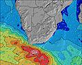 | 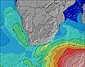 | 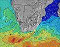 | ||||||||||||
Wave Height (m) Direction Period (s) | SSW 11 | SSW 16 | SSW 16 | SSW 15 | SSW 14 | SSW 13 | SSW 13 | SSW 12 | SSW 12 | SSW 14 | SSW 12 | SSW 16 | SSW 17 | SSW 16 | S 15 | SSW 15 | S 14 | SSW 14 | SSW 13 |
Wave Graph | |||||||||||||||||||
2092 | 2271 | 2731 | 1413 | 930 | 919 | 908 | 525 | 384 | 561 | 377 | 527 | 1417 | 1613 | 3409 | 2427 | 2107 | 934 | 563 | |
Wind (km/h) | |||||||||||||||||||
Wind State on-shore cross-onshore cross-shore cross-offshore off-shore glassy | cross-off | cross-off | on | cross-off | cross-off | on | cross | cross | cross-on | cross-off | cross-off | cross-off | cross-on | cross-on | cross-on | cross-on | on | cross-on | cross |
High Tide | 11:28PM1.07m | 12:39PM0.97m | 00:57AM1.11m | 1:47PM1.07m | 1:54AM1.19m | 2:30PM1.17m | 2:35AM1.29m | 3:05PM1.28m | 3:09AM1.38m | 3:36PM1.38m | 3:40AM1.45m | 4:05PM1.47m | 4:09AM1.50m | ||||||
Low Tide | 6:16AM0.62m | 6:27PM0.66m | 7:33AM0.54m | 7:41PM0.58m | 8:19AM0.44m | 8:27PM0.48m | 8:54AM0.33m | 9:03PM0.39m | 9:24AM0.23m | 9:35PM0.30m | 9:52AM0.15m | 10:06PM0.24m | |||||||
— | 7:11 | — | — | 7:09 | — | — | 7:09 | — | — | 7:09 | — | — | 7:07 | — | — | 7:07 | — | — | |
5:27 | — | 5:28 | — | — | 5:28 | — | — | 5:29 | — | — | 5:30 | — | — | 5:30 | — | — | 5:30 | — | |
mm | 18 | 2 | — | — | — | — | — | — | — | — | — | 2 | 7 | 2 | 2 | 8 | 2 | — | — |
Temp °C | 15 | 16 | 17 | 15 | 15 | 17 | 15 | 18 | 22 | 21 | 18 | 18 | 17 | 16 | 15 | 14 | 15 | 16 | 15 |
Feels °C | 12 | 12 | 14 | 12 | 13 | 16 | 12 | 14 | 17 | 16 | 12 | 13 | 14 | 12 | 13 | 10 | 12 | 11 | 11 |
Swell 1 Height (m) Direction Period (s) | SSW 11 | SSW 16 | SSW 16 | SSW 15 | SSW 14 | SSW 13 | SSW 13 | SSW 12 | SSW 12 | SSW 14 | SSW 12 | SSW 16 | SSW 17 | SSE 7 | S 15 | SSW 15 | S 14 | SSW 14 | SSW 13 |
1238 | 2271 | 2731 | 1413 | 930 | 919 | 908 | 525 | 384 | 561 | 377 | 527 | 1417 | 397 | 3409 | 2427 | 2107 | 934 | 563 | |
Swell 2 Height (m) Direction Period (s) | S 20 | SW 12 | SSE 8 | SSE 8 | SE 10 | SE 10 | ESE 10 | SE 9 | SSW 16 | E 7 | ENE 8 | SSW 12 | ENE 8 | SSW 16 | E 8 | ESE 7 | — | — | — |
284 | 558 | 210 | 171 | 290 | 236 | 161 | 86 | 337 | 109 | 51 | 294 | 22 | 1613 | 35 | 56 | — | — | — | |
Swell 3 Height (m) Direction Period (s) | SE 12 | SSE 8 | SE 11 | SE 10 | — | — | E 10 | S 16 | SE 9 | SE 8 | S 16 | E 8 | — | E 9 | — | E 9 | — | — | — |
66 | 226 | 58 | 65 | — | — | 2 | 190 | 36 | 11 | 135 | 33 | — | 25 | — | 39 | — | — | — | |
Wind waves Height (m) Direction Period (s) | SSW 11 | — | — | — | — | — | NE 3 | E 5 | E 6 | — | SW 4 | SSW 6 | S 8 | — | — | — | E 9 | E 6 | E 7 |
2092 | — | — | — | — | — | 5 | 12 | 41 | — | 26 | 66 | 488 | — | — | — | 39 | 275 | 569 | |
Nearest Offshore or Glassy | |||||||||||||||||||
Distance (km) | 106 | 104 | 115 | 0 | 0 | 36 | 36 | 36 | 106 | 0 | 313 | 587 | 186 | 367 | 158 | 158 | 141 | 731 | 15 |
Best forecast wave conditions in Eastern Cape (South) | |||||||||||||||||||
Best forecast wave conditions in South Africa | |||||||||||||||||||
Header Global | |||||||||||||||||||
- Map Icons:
 Break
Break Live Wave Height (m)
 Live Wind Speed (km/h)
 Surf Rating (10 Max)
 Ocean Swells (m)
- Wind Speed (km/h)


FREE! Surf-Forecast.com widget for your website
The surf report / weather widget below is available to embed on third party websites free of charge and provides a summary of our Kellys Beach surf forecast. Simply grab the html code snippet that we provide and paste it into your own site. You can choose your preferred language and metric/imperial units for the surf forecast feed to suit users of your site. Click here to get the code.
Information about the Kellys Beach Surf forecast
The above surf forecast table for Kellys Beach provides essential information for determining whether the surfing conditions will be good over the next 16 days. A general guide to surfing at Kellys Beach can be found by selecting the local surf guide option on the grey menu. Our Kellys Beach surf forecast is unique since it includes wave energy (power) that defines the real feel of the surf rather than just the height or the period. If you surf the same spot (Kellys Beach) regularly then make a mental note of the wave energy from the surf forecast table each time you go. Very soon you may start to choose your surf days based on the wave energy alone combined with our forecast of favourable offshore wind conditions. Our star ratings will help here and of course you will also find the usual wave height and period predictions on our surf forecasts as well as a full break down of the swell components under our advanced users option (to reveal that, click the little Einstein character under the tide times).
Further information to help with frequently asked questions about our surf forecast for Kellys Beach may be found under the help tab on the top menu and also by moving your mouse over the question marks on the surf forecast table itself. Please always bear in mind that the forecast is for near-shore open water and local factors at each surf break influence the actual breaking wave height, such as the beach / reef profile, water depths offshore and shelter.
Are you planning a holiday in Eastern Cape (South)? If you are looking for accommodation near Kellys Beach, camping, hotels and holiday cottages in Eastern Cape (South), consider staying in Port Alfred which is 15 km (9 miles) away. Other places in and around Eastern Cape (South) where you can find information about places to rent, and car hire include Grahamstown which is 43 km (27 miles) away, Fort Beaufort and Bisho.
 Nearest