

Surf Forecasts:

Jetty Park surf forecast from 3 Aug 2026:
- Most powerful swell: Saturday 8 Aug, 8AM (local time) - 4.5ft (1.4m), 8s period, E swell with 247 kJ wave energy.
Best Forecast Surf Conditions for Jetty Park this week:
The most powerful waves expected at Jetty Park in the next 16 days are 1.4m 8s and forecast to arrive on Saturday (Aug 08) at 8AM. Winds are predicted to be onshore at the time the swell arrives. The largest open ocean swell (not directed at the beach) is 0.1m 7s period and expected on Monday (Aug 03) at 8AM.
| Wave Type | Time (EDT) & Date | Wave Height & Period |
|---|---|---|
| Next good surf (1 star+) | - | - |
| Best Surf | - | - |
| Most Powerful | 8AM (Sat 8th Aug) | 4.5ft (1.4m) 8s |
Table - best surf conditions forecast for Jetty Park over the next 16 days.
The Lowdown
Alright folks, Rusty here. Let’s get real about the next few weeks. I’ve been staring at this stretch, and it’s a tough one. We’ve got a long, quiet run ahead, so don’t be in a rush to grab your board.
Right off the bat, we’ve got a gap with no real surf. From August 3rd all the way through to the 10th, it’s just tiny, weak waves. The swell energy is barely registering, with numbers like 37 (weak energy) dropping to 21 (weak energy). The swell is mostly from the east to southeast, but it’s small—1ft to 2ft—and the period is short, around 8 seconds or less. That’s not going to do much for us. You’ll be sitting out there bobbing around mostly. The wind does offer some relief: on the 5th morning we get glassy conditions, and the 3rd afternoon has a clean offshore WNW breeze. But with such small surf, it’s a polishing a turd situation.
The action starts to pick up a little around the 7th and 8th. The swell bumps up to 4ft to 4ft out of the east, with the period slowly climbing to 8 seconds. The combined energy jumps to 133 (moderate wave energy) on the 7th afternoon and even 311 (moderate wave energy) on the 8th afternoon. But here’s the kicker—the wind is onshore from the east both days, so it’s going to be choppy and messy. The wave comment says “unknown” but the state is onshore, so expect a bumpy ride. The 8th afternoon might be the best of a bad lot, but it’s still not going to be a stand-out session.
The real highlight, and the only true standout I can see in this whole 16-day window, is Monday, August 17th. We’re looking at a morning session at Jetty Park. The swell is from the southeast at 3ft, with a short period of 5 seconds. The energy is 62 (weak energy), so it’s not a groundswell. But the wind is offshore from the west, which is a major positive. That creates clean conditions. For a beginner-friendly spot like this, it’s the best setup we’ve got. The water temperature is about average for the time of year, so no surprises there.
The rest of the second week is a washout. From the 9th up to the 18th, it’s mostly small, weak, and onshore or cross-onshore. The swell is often under 2ft, with periods around 4 to 7 seconds, and energy readings in the teens and twenties. The 16th morning has a cross-offshore wind from the southwest, but the swell is only 2ft. It’s a tease.
So, bottom line: this is a long, quiet run. If you’re desperate, the 17th morning is your best bet for a clean, small wave at Jetty Park. Otherwise, save your energy. Forecasts can change, but right now, it’s a waiting game.
Rusty.
Short Range ForecastSome drizzle, heaviest during Tue night. Warm (max 29°C on Mon afternoon, min 24°C on Mon night). Wind will be generally light. | Days 5-7 Weather SummaryModerate rain (total 10mm), heaviest on Wed night. Warm (max 29°C on Wed night, min 27°C on Wed night). Wind will be generally light. | ||||||||||||||||||
Monday 3 | Tuesday 4 | Wednesday 5 | Thursday 6 | Friday 7 | Saturday 8 | ||||||||||||||
Night | AM | PM | Night | AM | PM | Night | AM | PM | Night | AM | PM | Night | AM | PM | Night | AM | PM | Night | |
Swell Height Map |  |  |  |  | 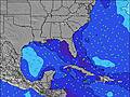 | 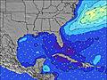 | 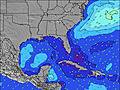 | ||||||||||||
Wave Height (m) Direction Period (s) | ESE 8 | ESE 8 | ESE 8 | ESE 8 | E 8 | E 8 | E 7 | E 7 | ESE 7 | ESE 7 | E 5 | E 5 | E 6 | E 6 | E 7 | E 8 | E 8 | E 8 | E 8 |
Wave Graph | |||||||||||||||||||
21 | 34 | 20 | 19 | 29 | 29 | 28 | 28 | 18 | 42 | 17 | 28 | 50 | 92 | 131 | 163 | 156 | 182 | 98 | |
Wind (km/h) | |||||||||||||||||||
Wind State on-shore cross-onshore cross-shore cross-offshore off-shore glassy | cross-off | cross-off | off | cross-off | cross-off | cross | cross | glassy | cross-on | cross-on | on | on | on | on | on | on | on | on | cross-on |
High Tide | 11:03PM1.11m | 11:34AM1.11m | 11:42PM1.09m | 12:23PM1.10m | 00:26AM1.06m | 1:18PM1.09m | 1:18AM1.04m | 2:20PM1.07m | 2:20AM1.03m | 3:29PM1.08m | 3:29AM1.05m | 4:39PM1.12m | 4:41AM1.09m | ||||||
Low Tide | 5:13AM0.02m | 5:34PM0.12m | 5:59AM0.01m | 6:25PM0.17m | 6:52AM0.01m | 7:23PM0.21m | 7:54AM0.01m | 8:29PM0.24m | 9:00AM-0.00m | 9:37PM0.23m | 10:07AM-0.03m | 10:43PM0.21m | |||||||
— | 6:45 | — | — | 6:45 | — | — | 6:46 | — | — | 6:46 | — | — | 6:47 | — | — | 6:47 | — | — | |
8:12 | — | 8:10 | — | — | 8:09 | — | — | 8:09 | — | — | 8:08 | — | — | 8:07 | — | — | 8:07 | — | |
mm | — | — | — | — | — | — | 1 | — | — | 4 | 1 | 1 | 1 | — | 2 | — | — | 1 | — |
Temp °C | 27 | 27 | 29 | 28 | 26 | 28 | 28 | 28 | 29 | 29 | 28 | 28 | 28 | 28 | 28 | 28 | 28 | 28 | 28 |
Feels °C | 29 | 28 | 30 | 30 | 28 | 31 | 32 | 33 | 32 | 32 | 30 | 31 | 31 | 30 | 30 | 31 | 32 | 31 | 32 |
Swell 1 Height (m) Direction Period (s) | SE 5 | ESE 8 | ESE 8 | ESE 8 | E 8 | E 8 | E 7 | E 7 | ESE 7 | — | E 7 | NE 10 | E 9 | E 10 | E 10 | NE 10 | E 8 | E 8 | NE 9 |
7 | 34 | 20 | 19 | 29 | 29 | 28 | 28 | 18 | — | 9 | 4 | 2 | 2 | 2 | 4 | 156 | 182 | 3 | |
Swell 2 Height (m) Direction Period (s) | ESE 8 | — | SSE 4 | — | S 4 | SSE 4 | — | — | — | — | E 10 | — | NE 11 | — | — | — | ENE 9 | NE 9 | — |
21 | — | 1 | — | 1 | 1 | — | — | — | — | 2 | — | 5 | — | — | — | 8 | 3 | — | |
Swell 3 Height (m) Direction Period (s) | — | — | — | — | — | — | — | — | — | — | — | — | — | — | — | — | — | — | — |
— | — | — | — | — | — | — | — | — | — | — | — | — | — | — | — | — | — | — | |
Wind waves Height (m) Direction Period (s) | — | S 4 | — | SE 2 | — | — | — | — | — | ESE 7 | E 5 | E 5 | E 6 | E 6 | E 7 | E 8 | — | E 8 | E 8 |
— | 3 | — | 1 | — | — | — | — | — | 42 | 17 | 28 | 50 | 92 | 131 | 163 | — | 129 | 98 | |
Nearest Offshore or Glassy | |||||||||||||||||||
Distance (km) | 55 | 157 | 1456 | 1027 | 157 | 55 | 60 | 157 | 677 | 157 | 660 | 1645 | 1379 | 498 | 498 | 498 | 498 | 1260 | 19 |
Best forecast wave conditions in North Florida | |||||||||||||||||||
Best forecast wave conditions in United States | |||||||||||||||||||
Header Global | |||||||||||||||||||
- Map Icons:
 Break
Break Live Wave Height (m)
 Live Wind Speed (km/h)
 Surf Rating (10 Max)
 Ocean Swells (m)
- Wind Speed (km/h)
Latest Updates


FREE! Surf-Forecast.com widget for your website
The surf report / weather widget below is available to embed on third party websites free of charge and provides a summary of our Jetty Park surf forecast. Simply grab the html code snippet that we provide and paste it into your own site. You can choose your preferred language and metric/imperial units for the surf forecast feed to suit users of your site. Click here to get the code.
Information about the Jetty Park Surf forecast
The above surf forecast table for Jetty Park provides essential information for determining whether the surfing conditions will be good over the next 16 days. A general guide to surfing at Jetty Park can be found by selecting the local surf guide option on the grey menu. Our Jetty Park surf forecast is unique since it includes wave energy (power) that defines the real feel of the surf rather than just the height or the period. If you surf the same spot (Jetty Park) regularly then make a mental note of the wave energy from the surf forecast table each time you go. Very soon you may start to choose your surf days based on the wave energy alone combined with our forecast of favourable offshore wind conditions. Our star ratings will help here and of course you will also find the usual wave height and period predictions on our surf forecasts as well as a full break down of the swell components under our advanced users option (to reveal that, click the little Einstein character under the tide times).
Further information to help with frequently asked questions about our surf forecast for Jetty Park may be found under the help tab on the top menu and also by moving your mouse over the question marks on the surf forecast table itself. Please always bear in mind that the forecast is for near-shore open water and local factors at each surf break influence the actual breaking wave height, such as the beach / reef profile, water depths offshore and shelter.
Jetty Park is 15 km (9 miles) from Cocoa. If you plan a vacation in North Florida, look for hotels and other accommodation in Cocoa. Cocoa has rooms for a wide range of budgets as well as car hire and transport links.
 Nearest