

Surf Forecasts:

El Cantal Roig surf forecast from 29 Jul 2026:
- Most powerful swell: Tuesday 4 Aug, 8AM (local time) - 1.5ft (0.4m), 7s period, SSW swell with 20 kJ wave energy.
Best Forecast Surf Conditions for El Cantal Roig this week:
The most powerful waves expected at El Cantal Roig in the next 16 days are 0.4m 7s and forecast to arrive on Tuesday (Aug 04) at 8AM. Winds are predicted to be offshore at the time the swell arrives. The largest open ocean swell (not directed at the beach) is 0.8m 6s period and expected on Wednesday (Jul 29) at 2PM.
| Wave Type | Time (CEST) & Date | Wave Height & Period |
|---|---|---|
| Next good surf (1 star+) | - | - |
| Best Surf | - | - |
| Most Powerful | 8AM (Tue 4th Aug) | 1.5ft (0.4m) 7s |
Table - best surf conditions forecast for El Cantal Roig over the next 16 days.
The Lowdown
Alright folks, Rusty here. The swell forecast for this part of the coast is pretty grim, so I’ll level with you straight up.
We’re looking at a long, quiet spell. From now until the morning of Monday the 3rd of August, there’s absolutely no surf on offer. Zero. A flat spell that lasts nearly a week is tough, but it happens here. The waiting game begins.
Things finally stir on Monday morning, the 3rd of August. It’s tiny, just a 1ft pulse from the south with a short, weak period of 4 seconds. The combined swell energy is a measly 2. It’s barely enough to wet the board, but the air is glassy, which is nice. Still, it’s a poor day for any real surfing.
Tuesday the 4th of August sees a slight improvement. Still small at 1ft from the SSW, but the period bumps up to 7 seconds, and the energy hits 20. The morning wind is offshore from the NNE, so El Cantal Roig (Spain) will look clean, but it won’t have enough push to get excited about. It remains a poor surf scenario overall.
The rest of the run into the second week is more of the same: tiny swells in the 0.6ft to 1ft range, mostly short period, and while we get some clean, glassy mornings and offshore breezes, the waves just aren’t there. The water here is running much warmer than normal for this time of year by a solid 3°, which is unusual, but that won’t help the flat spell.
So, the honest truth is there are no standouts in this 16-day window. The closest we get to a wave is on Tuesday the 4th, and that’s still a poor option. It’s a blank run that’s more normal for this area when the swell windows close up. Keep the board waxed nearby, because it tends not to stay this way forever, and forecasts can change.
Rusty.
Short Range ForecastMostly dry. Warm (max 29°C on Fri afternoon, min 24°C on Wed morning). Wind will be generally light. | Days 4-6 Weather SummaryMostly dry. Warm (max 31°C on Sun night, min 26°C on Sat morning). Wind will be generally light. | ||||||||||||||||||||
Wednesday 29 | Thursday 30 | Friday 31 | Saturday 1 | Sunday 2 | Monday 3 | Tuesday 4 | |||||||||||||||
AM | PM | Night | AM | PM | Night | AM | PM | Night | AM | PM | Night | AM | PM | Night | AM | PM | Night | AM | PM | Night | |
Swell Height Map |  |  |  | 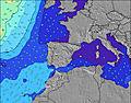 | 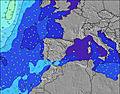 | 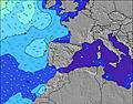 | 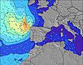 | ||||||||||||||
Wave Height (m) Direction Period (s) | SE 6 | ESE 6 | ESE 5 | ESE 5 | ESE 5 | ESE 5 | ESE 4 | SE 5 | ESE 5 | ESE 5 | ESE 5 | ESE 5 | ESE 5 | ESE 4 | SSW 3 | S 4 | S 4 | SSW 6 | SSW 7 | S 6 | S 4 |
Wave Graph | |||||||||||||||||||||
0 | 0 | 0 | 0 | 0 | 0 | 0 | 0 | 0 | 0 | 0 | 0 | 0 | 0 | 1 | 2 | 3 | 10 | 20 | 10 | 10 | |
Wind (km/h) | |||||||||||||||||||||
Wind State on-shore cross-onshore cross-shore cross-offshore off-shore glassy | cross-off | cross-on | cross-on | glassy | on | cross-on | glassy | cross-on | glassy | cross-off | cross | glassy | glassy | cross-on | cross-on | glassy | cross-off | glassy | off | cross-on | glassy |
High Tide | 1:10AM0.15m | 1:49AM0.14m | 2:16AM0.14m | 2:44AM0.13m | 3:04AM0.11m | 10:26PM0.10m | 8:24PM0.10m | ||||||||||||||
Low Tide | 11:01AM0.01m | 11:29AM0.01m | 11:51AM0.01m | 12:07PM0.02m | 12:16PM0.03m | 12:17PM0.04m | 10:59PM0.10m | 12:04PM0.05m | |||||||||||||
6:58 | — | — | 6:58 | — | — | 6:58 | — | — | 7:00 | — | — | 7:01 | — | — | 7:01 | — | — | 7:03 | — | — | |
— | — | 9:13 | — | — | 9:12 | — | — | 9:10 | — | — | 9:09 | — | — | 9:08 | — | — | 9:07 | — | — | 9:07 | |
mm | — | — | — | — | — | — | — | — | — | — | — | — | — | — | — | — | — | — | — | — | — |
Temp °C | 27 | 28 | 27 | 27 | 28 | 28 | 27 | 29 | 29 | 28 | 30 | 30 | 29 | 30 | 31 | 30 | 30 | 30 | 30 | 30 | 30 |
Feels °C | 29 | 29 | 28 | 29 | 29 | 29 | 30 | 29 | 29 | 31 | 31 | 30 | 32 | 34 | 34 | 32 | 33 | 32 | 33 | 32 | 31 |
Swell 1 Height (m) Direction Period (s) | SE 6 | ESE 6 | ESE 5 | ESE 5 | ESE 5 | ESE 5 | ESE 4 | SE 5 | ESE 5 | ESE 5 | ESE 5 | ESE 5 | ESE 5 | ESE 4 | ESE 4 | S 4 | S 4 | SSW 6 | SSW 7 | S 6 | S 4 |
35 | 47 | 19 | 19 | 19 | 9 | 8 | 14 | 10 | 9 | 9 | 7 | 7 | 7 | 2 | 2 | 3 | 10 | 20 | 10 | 6 | |
Swell 2 Height (m) Direction Period (s) | — | — | — | — | — | — | — | — | — | — | — | — | — | N 3 | — | E 4 | NNE 3 | NE 4 | NE 4 | NNE 5 | NE 4 |
— | — | — | — | — | — | — | — | — | — | — | — | — | 1 | — | 1 | 1 | 1 | 1 | 2 | 1 | |
Swell 3 Height (m) Direction Period (s) | — | — | — | — | — | — | — | — | — | — | — | — | — | — | — | — | — | — | — | NNE 5 | NE 5 |
— | — | — | — | — | — | — | — | — | — | — | — | — | — | — | — | — | — | — | 2 | 1 | |
Wind waves Height (m) Direction Period (s) | — | — | — | — | — | — | — | — | — | — | — | — | — | — | SSW 3 | — | N 3 | — | NNE 4 | — | S 4 |
— | — | — | — | — | — | — | — | — | — | — | — | — | — | 1 | — | 6 | — | 1 | — | 10 | |
Nearest Offshore or Glassy | |||||||||||||||||||||
Distance (km) | 53 | 550 | 583 | 585 | 581 | 549 | 549 | 669 | 623 | 549 | 580 | 549 | 620 | 737 | 443 | 378 | 669 | 573 | 378 | 784 | 396 |
Best forecast wave conditions in Valencia | |||||||||||||||||||||
Best forecast wave conditions in Spain (Europe) | |||||||||||||||||||||
Header Global | |||||||||||||||||||||
- Map Icons:
 Break
Break Live Wave Height (m)
 Live Wind Speed (km/h)
 Surf Rating (10 Max)
 Ocean Swells (m)
- Wind Speed (km/h)


FREE! Surf-Forecast.com widget for your website
The surf report / weather widget below is available to embed on third party websites free of charge and provides a summary of our El Cantal Roig surf forecast. Simply grab the html code snippet that we provide and paste it into your own site. You can choose your preferred language and metric/imperial units for the surf forecast feed to suit users of your site. Click here to get the code.
Information about the El Cantal Roig Surf forecast
The above surf forecast table for El Cantal Roig provides essential information for determining whether the surfing conditions will be good over the next 16 days. A general guide to surfing at El Cantal Roig can be found by selecting the local surf guide option on the grey menu. Our El Cantal Roig surf forecast is unique since it includes wave energy (power) that defines the real feel of the surf rather than just the height or the period. If you surf the same spot (El Cantal Roig) regularly then make a mental note of the wave energy from the surf forecast table each time you go. Very soon you may start to choose your surf days based on the wave energy alone combined with our forecast of favourable offshore wind conditions. Our star ratings will help here and of course you will also find the usual wave height and period predictions on our surf forecasts as well as a full break down of the swell components under our advanced users option (to reveal that, click the little Einstein character under the tide times).
Further information to help with frequently asked questions about our surf forecast for El Cantal Roig may be found under the help tab on the top menu and also by moving your mouse over the question marks on the surf forecast table itself. Please always bear in mind that the forecast is for near-shore open water and local factors at each surf break influence the actual breaking wave height, such as the beach / reef profile, water depths offshore and shelter.
El Cantal Roig is 2 km (1 miles) from Calp. If you plan a holiday in Valencia, look for hotels and other accommodation in Calp. Calp has rooms for a wide range of budgets as well as car hire and transport links.
 Nearest