

Surf Forecasts:

Spew Pits surf forecast from 3 Aug 2026:
- Most powerful swell: Saturday 8 Aug, 10AM (local time) - 6ft (1.8m), 8s period, N swell with 428 kJ wave energy.
Best Forecast Surf Conditions for Spew Pits this week:
The most powerful waves expected at Spew Pits in the next 16 days are 1.8m 8s and forecast to arrive on Saturday (Aug 08) at 10AM. Winds are predicted to be cross-offshore at the time the swell arrives. The largest open ocean swell (not directed at the beach) is 1.6m 6s period and expected on Friday (Aug 07) at 4AM.
| Wave Type | Time (WEST) & Date | Wave Height & Period |
|---|---|---|
| Next good surf (1 star+) | - | - |
| Best Surf | - | - |
| Most Powerful | 10AM (Sat 8th Aug) | 6ft (1.8m) 8s |
Table - best surf conditions forecast for Spew Pits over the next 16 days.
The Lowdown
Alright folks, Rusty here. Let’s have a look at what’s cooking for the next couple of weeks.
Honestly, it’s a pretty bleak stretch ahead. We’ve got a long run of poor surf conditions with hardly any real quality on offer. The first real chance of anything half-decent doesn’t roll in until Wednesday, August 12th, and even then it’s only marginal.
We’re stuck with a persistent northerly wind pattern – mostly cross-off or cross-shore – which is just not doing us any favours. The swell is small and weak for days, with combined energy values mostly sitting between 100 and 200 (moderate wave energy at best), and the period is short, around 6 to 8 seconds, meaning weak, disorganised waves. The water temperature is sitting at 73°F, which is about average for this time of year, so no surprises there.
The only spot in the game is Spew Pits (reef), an expert-only wave that’s looking for a north-northwest swell. It’s consistent, but it rarely gets a clean window. The wind is mostly cross-off, but the swell quality is just poor day after day.
The first hint of something surfable comes on Wednesday, August 12th, in the morning. We’ve got a 5ft swell from the north with a 7-second period, and combined energy jumps to 361 (moderate wave energy). The wind is light from the north-northeast at 9 mph, which is a gentle breeze and cross-off, making it clean. It’s still only a marginal call – a 1 out of 10 on the score – but it’s the closest thing to a window we’ve got. That’s the only day in the first week worth even checking.
After that, we go back into a long gap of poor surf with moderate to fresh cross-shore winds and lumpy, choppy conditions. The swell hangs around 4ft to 5ft but the period stays short and the wind chops it up.
Then, on Monday, August 17th, in the morning, we get another marginal window. The swell is 5ft from the north, period 8 seconds, combined energy 292 (moderate wave energy), and the wind is north-northeast at 12 mph, cross-off and clean. Again, not great, but it’s the best of a bad lot.
The real standout – if you want to call it that – is Tuesday, August 18th, in the morning. The swell picks up to 6ft from the north, period 8 seconds, and the combined energy jumps to 517 (strong wave energy). The wind is north-northeast at 16 mph, cross-off and clean. That’s the biggest swell of the whole forecast, and it’s the only day with strong energy. It’s still only a marginal score, but if you’re an expert willing to sit and wait, that Tuesday morning is your best bet. The water will be clean, the sets will have a bit more punch, but remember, at 6ft, this is expert territory at Spew Pits.
So, to sum it up: it’s a long, quiet spell. The best on offer is the morning of Tuesday, August 18th, with 6ft north swell and clean conditions. The Wednesday, August 12th, morning is a distant second with 5ft and light winds. Don’t expect much else.
Rusty.
Short Range ForecastMostly dry. Warm (max 24°C on Mon morning, min 21°C on Mon night). Mainly fresh winds. | Days 4-6 Weather SummaryMostly dry. Warm (max 22°C on Thu morning, min 20°C on Thu night). Mainly fresh winds. | ||||||||||||||||||||
Monday 3 | Tuesday 4 | Wednesday 5 | Thursday 6 | Friday 7 | Saturday 8 | Sunday 9 | |||||||||||||||
AM | PM | Night | AM | PM | Night | AM | PM | Night | AM | PM | Night | AM | PM | Night | AM | PM | Night | AM | PM | Night | |
Swell Height Map |  |  |  | 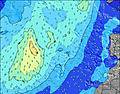 | 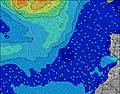 | 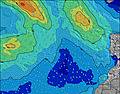 | 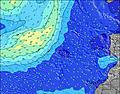 | ||||||||||||||
Wave Height (m) Direction Period (s) | N 6 | N 6 | WNW 9 | N 6 | N 7 | WNW 8 | NNE 7 | WNW 11 | WNW 10 | NNE 6 | N 10 | N 9 | N 8 | N 8 | N 8 | N 8 | N 8 | N 8 | N 8 | N 8 | N 7 |
Wave Graph | |||||||||||||||||||||
61 | 59 | 34 | 67 | 71 | 47 | 153 | 75 | 58 | 142 | 67 | 348 | 323 | 373 | 363 | 428 | 382 | 305 | 240 | 198 | 127 | |
Wind (km/h) | |||||||||||||||||||||
Wind State on-shore cross-onshore cross-shore cross-offshore off-shore glassy | cross-off | cross-off | cross-off | cross-off | cross-off | cross-off | cross-off | cross-off | cross-off | cross-off | cross-off | cross-off | cross | cross-off | cross | cross-off | cross | cross | cross-off | cross | cross-off |
High Tide | 5:13PM2.21m | 5:39AM2.01m | 5:54PM2.09m | 6:25AM1.92m | 6:46PM1.94m | 7:24AM1.83m | 7:54PM1.81m | 8:41AM1.77m | 9:23PM1.75m | 10:09AM1.82m | 10:54PM1.80m | 11:27AM1.97m | 00:06AM1.95m | ||||||||
Low Tide | 10:56AM0.35m | 11:26PM0.31m | 11:36AM0.44m | 00:08AM0.41m | 12:26PM0.54m | 1:01AM0.53m | 1:30PM0.64m | 2:11AM0.64m | 2:57PM0.69m | 3:40AM0.67m | 4:33PM0.61m | 5:05AM0.59m | 5:50PM0.44m | ||||||||
7:18 | — | — | 7:18 | — | — | 7:18 | — | — | 7:18 | — | — | 7:20 | — | — | 7:20 | — | — | 7:20 | — | — | |
— | 8:45 | — | — | 8:45 | — | — | 8:44 | — | — | 8:43 | — | — | 8:43 | — | — | 8:42 | — | — | 8:40 | — | |
mm | — | — | — | — | — | — | — | — | — | — | — | — | — | — | — | — | — | — | — | — | — |
Temp °C | 24 | 24 | 21 | 24 | 24 | 21 | 23 | 23 | 21 | 22 | 22 | 21 | 22 | 22 | 21 | 22 | 22 | 21 | 22 | 22 | 21 |
Feels °C | 21 | 21 | 20 | 21 | 21 | 19 | 20 | 20 | 19 | 20 | 20 | 19 | 20 | 21 | 20 | 21 | 21 | 20 | 21 | 20 | 20 |
Swell 1 Height (m) Direction Period (s) | WNW 9 | WNW 9 | WNW 9 | WNW 9 | ENE 7 | WNW 8 | NW 8 | ENE 8 | WNW 10 | N 10 | NE 8 | WNW 9 | WNW 9 | WNW 9 | NW 9 | NW 9 | NW 8 | NW 8 | WNW 8 | WNW 8 | NW 8 |
55 | 32 | 34 | 32 | 36 | 47 | 16 | 78 | 58 | 51 | 69 | 34 | 32 | 32 | 20 | 20 | 18 | 17 | 13 | 13 | 14 | |
Swell 2 Height (m) Direction Period (s) | NE 7 | ENE 7 | N 9 | ENE 7 | WNW 9 | N 8 | NW 10 | WNW 11 | NNW 11 | WNW 10 | N 10 | NW 9 | WNW 9 | WNW 9 | WNW 9 | WNW 9 | WNW 9 | WNW 8 | WNW 8 | WNW 8 | N 12 |
14 | 21 | 13 | 19 | 30 | 1 | 26 | 75 | 24 | 55 | 67 | 23 | 16 | 16 | 16 | 15 | 15 | 7 | 6 | 6 | 3 | |
Swell 3 Height (m) Direction Period (s) | N 9 | N 9 | — | N 8 | WNW 11 | — | N 11 | N 11 | N 11 | — | WNW 10 | — | — | — | — | — | — | N 11 | N 8 | — | W 12 |
14 | 14 | — | 5 | 12 | — | 2 | 2 | 2 | — | 37 | — | — | — | — | — | — | 2 | 1 | — | 3 | |
Wind waves Height (m) Direction Period (s) | N 6 | N 6 | NNE 6 | N 6 | N 7 | NNE 6 | NNE 7 | N 6 | NNE 6 | NNE 6 | N 6 | N 9 | N 8 | N 8 | N 8 | N 8 | N 8 | N 8 | N 8 | N 8 | N 7 |
61 | 59 | 60 | 67 | 71 | 86 | 153 | 68 | 96 | 142 | 106 | 348 | 323 | 373 | 363 | 428 | 382 | 305 | 240 | 198 | 127 | |
Nearest Offshore or Glassy | |||||||||||||||||||||
Distance (km) | 26 | 26 | 26 | 226 | 26 | 207 | 207 | 274 | 207 | 207 | 207 | 207 | 207 | 207 | 275 | 462 | 274 | 211 | 207 | 207 | 207 |
Best forecast wave conditions in Fuerteventura | |||||||||||||||||||||
Best forecast wave conditions in Spain (Africa) | |||||||||||||||||||||
Header Global | |||||||||||||||||||||
- Map Icons:
 Break
Break Live Wave Height (m)
 Live Wind Speed (km/h)
 Surf Rating (10 Max)
 Ocean Swells (m)
- Wind Speed (km/h)
Latest Updates


FREE! Surf-Forecast.com widget for your website
The surf report / weather widget below is available to embed on third party websites free of charge and provides a summary of our Spew Pits surf forecast. Simply grab the html code snippet that we provide and paste it into your own site. You can choose your preferred language and metric/imperial units for the surf forecast feed to suit users of your site. Click here to get the code.
Information about the Spew Pits Surf forecast
The above surf forecast table for Spew Pits provides essential information for determining whether the surfing conditions will be good over the next 16 days. A general guide to surfing at Spew Pits can be found by selecting the local surf guide option on the grey menu. Our Spew Pits surf forecast is unique since it includes wave energy (power) that defines the real feel of the surf rather than just the height or the period. If you surf the same spot (Spew Pits) regularly then make a mental note of the wave energy from the surf forecast table each time you go. Very soon you may start to choose your surf days based on the wave energy alone combined with our forecast of favourable offshore wind conditions. Our star ratings will help here and of course you will also find the usual wave height and period predictions on our surf forecasts as well as a full break down of the swell components under our advanced users option (to reveal that, click the little Einstein character under the tide times).
Further information to help with frequently asked questions about our surf forecast for Spew Pits may be found under the help tab on the top menu and also by moving your mouse over the question marks on the surf forecast table itself. Please always bear in mind that the forecast is for near-shore open water and local factors at each surf break influence the actual breaking wave height, such as the beach / reef profile, water depths offshore and shelter.
Are you planning a holiday in Fuerteventura? If you are looking for accommodation near Spew Pits, camping, hotels and holiday cottages in Fuerteventura, consider staying in La Oliva which is 14 km (9 miles) away. Other places in and around Fuerteventura where you can find information about places to rent, and car hire include Puerto del Rosario which is 27 km (17 miles) away, Pajara, Puerto del Carmen and Tias.
 Nearest