

Surf Forecasts:

How big are the waves at Baker s Beach today (19 Jun):
- Morning surf: Morning surf (19 Jun, local time) - 4ft (1.2m), 8s period with SSW swell.
- Afternoon surf: Afternoon surf (19 Jun, local time) - 4.5ft (1.4m), 8s period with SSW swell.
- Evening surf: Evening surf (19 Jun, local time) - 5ft (1.5m), 8s period with SSW swell.
The current surf forecast for Baker s Beach at 9AM is: 1.2m 8s primary swell from a South-southwest direction and 0.1m 14s secondary swell from a South direction (forecast issued at 01:00am June 19). The wind direction is predicted to be cross-shore.
| Time (EDT) & Date | Wave Height | Wave Period |
|---|---|---|
| Morning (19 Jun) | 4ft (1.2m) | 8s |
| Afternoon (19 Jun) | 4.5ft (1.4m) | 8s |
| Evening (19 Jun) | 5ft (1.5m) | 8s |
Table - waves today at Baker s Beach. (Swell directed towards the surf break)
Updates in hr min s Forecast update imminent
Short Range ForecastMostly dry. Warm (max 23°C on Sat afternoon, min 15°C on Sat night). Winds decreasing (fresh winds from the SW on Fri afternoon, light winds from the WNW by Sat night). | ||||||||||||||||||||||||
Friday 19 | Saturday 20 | Sunday 21 | ||||||||||||||||||||||
2 AM | 5 AM | 8 AM | 11 AM | 2 PM | 5 PM | 8 PM | 11 PM | 2 AM | 5 AM | 8 AM | 11 AM | 2 PM | 5 PM | 8 PM | 11 PM | 2 AM | 5 AM | 8 AM | 11 AM | 2 PM | 5 PM | 8 PM | 11 PM | |
Swell Height Map | 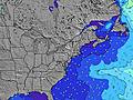 | 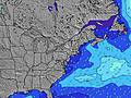 |  | 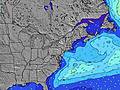 | 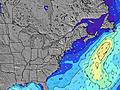 |  | 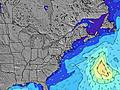 | 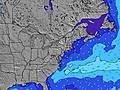 |  | |||||||||||||||
Wave Height (m) Direction Period (s) | SSW 8 | SSW 8 | SSW 8 | SSW 8 | SSW 8 | SSW 8 | SSW 8 | SSW 8 | SSW 8 | SSW 8 | SSW 8 | SSW 8 | SSW 7 | SSW 7 | SSW 7 | SSW 7 | SSW 7 | SSW 7 | SSW 7 | SSW 7 | SSW 4 | SSW 5 | SSW 5 | SSW 5 |
Wave Graph | ||||||||||||||||||||||||
266 | 464 | 155 | 151 | 204 | 257 | 298 | 458 | 176 | 125 | 92 | 101 | 96 | 93 | 93 | 86 | 72 | 76 | 61 | 41 | 25 | 46 | 38 | 31 | |
Wind (km/h) | ||||||||||||||||||||||||
Wind State on-shore cross-onshore cross-shore cross-offshore off-shore glassy | cross | cross | cross | cross-on | cross-on | cross-on | cross-on | cross | cross-off | cross | cross | cross | cross | cross | cross-off | cross-off | cross-off | cross-off | cross | cross-on | cross-on | cross-on | cross-on | cross-on |
High Tide | 11:47PM1.11m | 12:19PM1.00m | 00:41AM1.01m | 1:15PM0.98m | 1:36AM0.93m | 2:11PM0.97m | ||||||||||||||||||
Low Tide | 6:10AM-0.05m | 6:30PM0.03m | 7:03AM0.01m | 7:37PM0.09m | 7:58AM0.06m | 8:48PM0.14m | ||||||||||||||||||
— | 5:09 | — | — | — | — | — | — | — | 5:09 | — | — | — | — | — | — | — | 5:09 | — | — | — | — | — | — | |
— | — | — | — | — | — | 8:21 | — | — | — | — | — | — | — | 8:21 | — | — | — | — | — | — | — | 8:21 | — | |
mm | — | — | — | — | — | — | — | — | — | — | — | — | — | — | — | — | — | — | — | — | — | — | — | — |
Temp °C | 19 | 20 | 19 | 20 | 20 | 20 | 20 | 19 | 18 | 17 | 18 | 21 | 23 | 22 | 22 | 19 | 17 | 15 | 17 | 20 | 20 | 20 | 20 | 20 |
Feels °C | 18 | 17 | 16 | 16 | 14 | 15 | 17 | 17 | 15 | 12 | 13 | 17 | 19 | 19 | 19 | 17 | 15 | 13 | 15 | 18 | 15 | 17 | 17 | 19 |
Swell 1 Height (m) Direction Period (s) | SSW 8 | SSW 8 | SSW 8 | — | — | S 13 | SE 13 | SSW 8 | SSW 8 | SSW 8 | SSW 8 | S 13 | SSW 7 | S 13 | SSW 7 | SSW 7 | SSW 7 | SSW 7 | SSW 7 | SSW 7 | — | — | SSW 8 | SSW 7 |
266 | 232 | 155 | — | — | 3 | 7 | 250 | 176 | 125 | 92 | 3 | 96 | 3 | 93 | 86 | 72 | 76 | 61 | 41 | — | — | 6 | 5 | |
Swell 2 Height (m) Direction Period (s) | S 14 | S 14 | S 14 | — | — | — | — | S 13 | S 13 | S 13 | S 13 | — | S 13 | — | — | — | — | — | — | — | — | — | S 12 | — |
4 | 4 | 4 | — | — | — | — | 3 | 3 | 3 | 3 | — | 3 | — | — | — | — | — | — | — | — | — | 3 | — | |
Swell 3 Height (m) Direction Period (s) | — | — | — | — | — | — | — | — | — | — | — | — | — | — | — | — | — | — | — | — | — | — | — | — |
— | — | — | — | — | — | — | — | — | — | — | — | — | — | — | — | — | — | — | — | — | — | — | — | |
Wind waves Height (m) Direction Period (s) | — | SSW 8 | — | SSW 8 | SSW 8 | SSW 8 | SSW 8 | SSW 8 | — | — | W 3 | SSW 8 | — | SSW 7 | — | WNW 2 | WNW 2 | WNW 3 | WNW 2 | — | SSW 4 | SSW 5 | SSW 5 | SSW 5 |
— | 464 | — | 151 | 204 | 257 | 298 | 458 | — | — | 6 | 101 | — | 93 | — | 1 | 1 | 1 | 1 | — | 25 | 46 | 38 | 31 | |
Nearest Offshore or Glassy | ||||||||||||||||||||||||
Distance (km) | 2 | 33 | 29 | 34 | 102 | 199 | 29 | 2 | 29 | 29 | 285 | 278 | 36 | 36 | 17 | 0 | 2 | 2 | 36 | 36 | 576 | 576 | 576 | 576 |
Best forecast wave conditions in Rhode Island | ||||||||||||||||||||||||
Best forecast wave conditions in United States | ||||||||||||||||||||||||
Header Global | ||||||||||||||||||||||||
- Map Icons:
 Break
Break Live Wave Height (m)
 Live Wind Speed (km/h)
 Surf Rating (10 Max)
 Ocean Swells (m)
- Wind Speed (km/h)


FREE! Surf-Forecast.com widget for your website
The surf report / weather widget below is available to embed on third party websites free of charge and provides a summary of our Baker s Beach surf forecast. Simply grab the html code snippet that we provide and paste it into your own site. You can choose your preferred language and metric/imperial units for the surf forecast feed to suit users of your site. Click here to get the code.
 Nearest