

Surf Forecasts:

Aoura surf forecast from 3 Aug 2026:
- Best quality surf: Wednesday 5 Aug, 3PM (local time) - 16ft (5.0m), 18s period, ESE swell with cross-shore winds.
- Most powerful swell: Friday 7 Aug, 12AM (local time) - 26ft (8.0m), 17s period, SE swell with 40,237 kJ wave energy.
- Next surfable swell (1★+): Wednesday 5 Aug, 3PM (local time) - 16ft (5.0m), 18s period with ESE swell.
Best Forecast Surf Conditions for Aoura this week:
The surf forecast for Aoura over the next 16 days: The first swell (rated 1 star or higher) is forecast to arrive on Wednesday (Aug 05) at 3PM. The primary swell is predicted to be 5.0m and 18s period. The wind is predicted to be cross-shore as the swell arrives.
The most powerful waves expected at Aoura in the next 16 days are 8.0m 17s and forecast to arrive on Friday (Aug 07) at 12AM. Winds are predicted to be cross-shore at the time the swell arrives. The largest open ocean swell (not directed at the beach) is 7.5m 16s period and expected on Friday (Aug 07) at 9AM.
| Wave Type | Time (JST) & Date | Wave Height & Period |
|---|---|---|
| Next good surf (1 star+) | 3PM (Wed 5th Aug) | 16ft (5.0m) 18s |
| Best Surf | 3PM (Wed 5th Aug) | 16ft (5.0m) 18s |
| Most Powerful | 12AM (Fri 7th Aug) | 26ft (8.0m) 17s |
Table - best surf conditions forecast for Aoura over the next 16 days.
The Lowdown
G'day, I'm Rusty, and I'm staring at the window for Aoura. It's a tricky one, a real reef setup that needs everything to line up, and honestly, it's a massive wait for the pay-off. We're looking at an advanced wave that is inconsistent, and for the first week and a half, it's a complete write-off. The swell is pumping, but it’s just too big, and the wind is a mess. From Monday the 3rd of August right through to the middle of the month, the onshore and cross-shore winds are just tearing it apart. The water temp is sitting right around average for the time of year at 84.9°, nothing unusual there.
The first sniff of something half-decent doesn't come until the morning of Monday the 17th of August. Finally, the wind turns cross-off, and we get a clean 16.4ft swell from the east. The energy is pumping (14,338), and the period is a solid 13 seconds, so it's a proper groundswell. But look, this is a reef break, and that kind of size at 16.4ft is genuinely only for the experts. It's clean, but it's a beast. The crowds are something to think about here too, as they can be a problem.
Then, the real standout. Tuesday the 18th of August morning is the best on offer. The swell drops to a still very solid 11.5ft from the east, but the wind is light and cross-off – glassy conditions. The energy is still strong (3,765), and with a 12-second period, it's got heaps of power. The forecast says "excellent surf conditions for experienced surfers," which is bang on. This is the window. For a reef, the long period and east swell mean it should be a ripper, but it's a spot that rarely breaks well, so when it's on, you've got to be on it. The crowd factor is still a thing, so you might have some company for those perfect sets.
The afternoon of the 18th is still a decent 9.8ft, but the wind shifts onshore, chopping it up a bit. Everything before that is a dusty, blown-out, or just too big mess. The first week is a total loss, with a solid 10-day gap of no good surf. It's a long wait, but that Tuesday morning looks like it could be a session to remember for the crew who can handle it.
Short Range ForecastHeavy rain (total 40mm), heaviest during Mon night. Warm (max 30°C on Mon morning, min 27°C on Mon night). Winds increasing (light winds from the NE on Mon night, near gales from the NE by Wed night). | Days 4-6 Weather SummaryHeavy rain (total 92mm), heaviest during Thu night. Warm (max 29°C on Fri morning, min 28°C on Thu morning). Mainly near gales. | ||||||||||||||||||||
Monday 3 | Tuesday 4 | Wednesday 5 | Thursday 6 | Friday 7 | Saturday 8 | Sunday 9 | |||||||||||||||
AM | PM | Night | AM | PM | Night | AM | PM | Night | AM | PM | Night | AM | PM | Night | AM | PM | Night | AM | PM | Night | |
Swell Height Map |  |  |  | 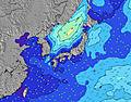 | 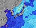 | 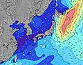 | 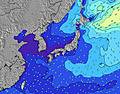 | ||||||||||||||
Wave Height (m) Direction Period (s) | ESE 16 | ESE 16 | ESE 17 | E 17 | ESE 17 | ESE 17 | ESE 17 | ESE 18 | ESE 17 | ESE 18 | ESE 17 | SE 17 | ESE 16 | SE 16 | ESE 11 | ESE 10 | ESE 10 | ESE 9 | ESE 10 | ESE 10 | ESE 9 |
Wave Graph | |||||||||||||||||||||
1038 | 1428 | 2171 | 4066 | 5087 | 6449 | 11066 | 15282 | 20762 | 29334 | 32918 | 40237 | 29781 | 14361 | 6448 | 4125 | 2947 | 2133 | 2040 | 2710 | 2296 | |
Wind (km/h) | |||||||||||||||||||||
Wind State on-shore cross-onshore cross-shore cross-offshore off-shore glassy | cross-off | cross | cross-off | cross | cross | cross | cross | cross | cross | cross | cross | cross | cross-on | cross-on | cross-on | cross-on | cross-on | cross-on | cross-on | cross-on | cross-on |
High Tide | 9:15PM1.99m | 9:21AM1.85m | 9:45PM1.97m | 10:16AM1.75m | 10:19PM1.93m | 11:29AM1.64m | 11:02PM1.88m | 1:17PM1.59m | 00:03AM1.82m | 3:25PM1.66m | 1:32AM1.80m | 4:41PM1.80m | |||||||||
Low Tide | 2:51PM0.54m | 3:23AM0.72m | 3:24PM0.72m | 4:09AM0.69m | 4:02PM0.92m | 5:05AM0.67m | 4:49PM1.14m | 6:17AM0.66m | 6:03PM1.33m | 7:45AM0.60m | 8:05PM1.43m | 9:10AM0.47m | 9:49PM1.38m | ||||||||
5:30 | — | — | 5:31 | — | — | 5:31 | — | — | 5:31 | — | — | 5:33 | — | — | 5:33 | — | — | 5:33 | — | — | |
— | 7:08 | — | — | 7:07 | — | — | 7:07 | — | — | 7:07 | — | — | 7:06 | — | — | 7:05 | — | — | 7:04 | — | |
mm | — | 3 | 16 | 4 | 5 | 4 | 3 | 1 | 4 | 5 | 4 | 15 | 7 | 8 | 16 | 9 | 10 | 18 | 10 | 10 | 16 |
Temp °C | 30 | 30 | 28 | 28 | 29 | 28 | 28 | 29 | 28 | 28 | 28 | 28 | 29 | 28 | 28 | 28 | 28 | 28 | 28 | 28 | 27 |
Feels °C | 32 | 32 | 31 | 30 | 31 | 30 | 27 | 28 | 27 | 24 | 24 | 24 | 26 | 25 | 25 | 26 | 26 | 26 | 25 | 25 | 24 |
Swell 1 Height (m) Direction Period (s) | ESE 16 | ESE 16 | ESE 17 | E 17 | ESE 17 | ESE 17 | ESE 17 | ESE 18 | ESE 17 | ESE 18 | ESE 17 | SE 17 | SSE 16 | SE 16 | SSE 16 | SSE 14 | SSE 14 | SSE 14 | SSE 13 | S 12 | S 11 |
1038 | 1428 | 2171 | 4066 | 5087 | 6449 | 11066 | 15282 | 20762 | 29334 | 32918 | 40237 | 28549 | 14361 | 9803 | 5858 | 4720 | 3119 | 1893 | 1254 | 746 | |
Swell 2 Height (m) Direction Period (s) | ENE 14 | ENE 15 | ENE 6 | — | — | — | — | — | — | — | — | — | — | — | — | — | — | — | — | — | S 16 |
21 | 42 | 64 | — | — | — | — | — | — | — | — | — | — | — | — | — | — | — | — | — | 192 | |
Swell 3 Height (m) Direction Period (s) | SSE 10 | S 7 | — | — | — | — | — | — | — | — | — | — | — | — | — | — | — | — | — | — | — |
9 | 4 | — | — | — | — | — | — | — | — | — | — | — | — | — | — | — | — | — | — | — | |
Wind waves Height (m) Direction Period (s) | SSE 7 | NE 4 | ENE 6 | E 7 | E 8 | — | — | — | — | — | ENE 10 | ESE 17 | ESE 16 | E 12 | ESE 11 | ESE 10 | ESE 10 | ESE 9 | ESE 10 | ESE 10 | ESE 9 |
5 | 14 | 115 | 285 | 447 | — | — | — | — | — | 4188 | 38901 | 29781 | 7557 | 6448 | 4125 | 2947 | 2133 | 2040 | 2710 | 2296 | |
Nearest Offshore or Glassy | |||||||||||||||||||||
Distance (km) | 32 | 32 | 32 | 32 | 32 | 32 | 302 | 853 | 302 | 848 | 1368 | 802 | 1452 | 802 | 353 | 656 | 802 | 802 | 1729 | 1368 | 298 |
Best forecast wave conditions in Kyu Shu | |||||||||||||||||||||
Best forecast wave conditions in Japan | |||||||||||||||||||||
Header Global | |||||||||||||||||||||
- Map Icons:
 Break
Break Live Wave Height (m)
 Live Wind Speed (km/h)
 Surf Rating (10 Max)
 Ocean Swells (m)
- Wind Speed (km/h)
Latest Updates


FREE! Surf-Forecast.com widget for your website
The surf report / weather widget below is available to embed on third party websites free of charge and provides a summary of our Aoura surf forecast. Simply grab the html code snippet that we provide and paste it into your own site. You can choose your preferred language and metric/imperial units for the surf forecast feed to suit users of your site. Click here to get the code.
Information about the Aoura Surf forecast
The above surf forecast table for Aoura provides essential information for determining whether the surfing conditions will be good over the next 16 days. A general guide to surfing at Aoura can be found by selecting the local surf guide option on the grey menu. Our Aoura surf forecast is unique since it includes wave energy (power) that defines the real feel of the surf rather than just the height or the period. If you surf the same spot (Aoura) regularly then make a mental note of the wave energy from the surf forecast table each time you go. Very soon you may start to choose your surf days based on the wave energy alone combined with our forecast of favourable offshore wind conditions. Our star ratings will help here and of course you will also find the usual wave height and period predictions on our surf forecasts as well as a full break down of the swell components under our advanced users option (to reveal that, click the little Einstein character under the tide times).
Further information to help with frequently asked questions about our surf forecast for Aoura may be found under the help tab on the top menu and also by moving your mouse over the question marks on the surf forecast table itself. Please always bear in mind that the forecast is for near-shore open water and local factors at each surf break influence the actual breaking wave height, such as the beach / reef profile, water depths offshore and shelter.
Aoura is 9 km (6 miles) from Nichinan. If you plan a holiday in Kyu Shu, look for hotels and other accommodation in Nichinan. Nichinan has rooms for a wide range of budgets as well as car hire and transport links.
 Nearest