

Surf Forecasts:

Asakawa surf forecast from 3 Aug 2026:
- Best quality surf: Friday 7 Aug, 12AM (local time) - 21ft (6.5m), 16s period, SSE swell with cross-shore winds.
- Most powerful swell: Thursday 6 Aug, 3PM (local time) - 20ft (6.0m), 16s period, SE swell with 19,205 kJ wave energy.
- Next surfable swell (1★+): Tuesday 4 Aug, 9PM (local time) - 13ft (4.0m), 16s period with ESE swell.
Best Forecast Surf Conditions for Asakawa this week:
The surf forecast for Asakawa over the next 16 days: The first swell (rated 1 star or higher) is forecast to arrive on Tuesday (Aug 04) at 9PM. The primary swell is predicted to be 4.0m and 16s period with a secondary swell of 3.5m and 16s. The wind is predicted to be glassy as the swell arrives.
The most powerful waves expected at Asakawa in the next 16 days are 6.0m 16s and forecast to arrive on Thursday (Aug 06) at 3PM. Winds are predicted to be cross-shore at the time the swell arrives.
| Wave Type | Time (JST) & Date | Wave Height & Period |
|---|---|---|
| Next good surf (1 star+) | 9PM (Tue 4th Aug) | 13ft (4.0m) 16s |
| Best Surf | 12AM (Fri 7th Aug) | 21ft (6.5m) 16s |
| Most Powerful | 3PM (Thu 6th Aug) | 20ft (6.0m) 16s |
Table - best surf conditions forecast for Asakawa over the next 16 days.
The Lowdown
Alright, surf is finally starting to show some real teeth around here. The first couple of days are a bit sketchy, but we’ve got a solid pulse of energy pushing in mid-week that’s worth getting excited about. It’s a typical summer setup for this stretch of coast, so you gotta pick your moments.
The main window kicks off on Tuesday the 4th, but honestly, it’s a bit of a washout. We’ve got a 10ft ESE swell with a 16-second period, but the wind is all wrong – cross-onshore and bumpy. The combined energy is strong at 7009, but it’s messy. Not a day for a clean session; more like a day to watch from the sand. The water temp is about average for this time of year, nothing wild there. Asakawa is inconsistent at the best of times, so you need the conditions to line up, and Tuesday isn't it.
Now, Wednesday the 5th is where it starts to get real. That same swell fills in and cleans up. The morning has a 15ft ESE swell with a 16-second period, and the wind switches to a light cross-shore breeze. The energy jumps to 10647, which is strong. It’s still a bit raw, but it’s rideable. The afternoon, though, is the standout. The swell pushes to 16ft from the SE with a 16-second period, and the wind drops to a light 6 mph cross-shore breeze. The energy is pumping at 13671. This is clean, powerful, and lined up. For a point break like Asakawa, this is where the long-period swell will really shine. It’s a big day though – over 8ft – so this is strictly for the experienced crew. Beginners, sit this one out. This is the best offer of the first week.
Thursday the 6th keeps the size, with 20ft SE swells and 16-second periods, but the wind picks up to a moderate 16 mph cross-shore. It’s going to be a bit of a battle out there. The energy is very strong (17647 in the morning, 19205 in the afternoon), but the chop will make it challenging. Still good for experts, but the quality drops off from Wednesday afternoon.
Friday the 7th is a strange one. The morning swell is huge at 20ft from the SSE, but the wave comment says it’s just too big for this break. The energy is massive at 30006, but that’s not a good thing here – it’s just going to be a closeout mess. Then the wind swings cross-onshore in the afternoon, and the swell drops to 13ft from the south. The score drops to zero. That’s a hard pass.
From Saturday the 8th onwards, it’s a slow fade. The swell drops each day, the wind stays onshore or cross-onshore, and the energy weakens. The scores are all poor or marginal. We’re looking at 10ft on Saturday dropping to 7ft by Monday, and the period drops as well. There’s a lot of chop and rain around. It’s a bleak stretch.
There’s a long gap of poor options from the 8th through to the 14th. It’s not until Sunday the 16th that things perk up again. The morning has a small 6ft ESE swell with a long 10-second period, and the wind is finally offshore – a clean cross-offshore breeze. The energy is moderate at 1105, but it’s clean. Then the afternoon is the real long-range promise. The swell jumps to 13ft from the ESE with a 12-second period, the wind stays cross-offshore, and the energy climbs to 4639. It’s still a week and a half out, so treat it as promising but not certain. But if it holds, that could be another solid session for the experts.
After that, the wind turns onshore again and it all gets messy. The last real glimpse is Wednesday the 19th with a clean 3ft E swell, but the period is long at 14 seconds and the energy is weak. It’s a marginal one at best.
So, bottom line: your two standout windows are Wednesday afternoon the 5th, and possibly the afternoon of Sunday the 16th. Both are big, powerful swells that need a skilled hand. Between the 8th and the 14th, there’s just nothing worth paddling out for. The inconsistent nature of this spot means that a blank run like this is pretty normal. But when it fires, it’s worth the wait.
Stay stoked.
Rusty
Short Range ForecastModerate rain (total 11mm), heaviest on Thu afternoon. Warm (max 31°C on Wed afternoon, min 25°C on Tue night). Wind will be generally light. | Days 5-7 Weather SummaryHeavy rain (total 50mm), heaviest during Sat night. Warm (max 30°C on Fri morning, min 26°C on Thu night). Wind will be generally light. | ||||||||||||||||||
Tuesday 4 | Wednesday 5 | Thursday 6 | Friday 7 | Saturday 8 | Sunday 9 | ||||||||||||||
Night | AM | PM | Night | AM | PM | Night | AM | PM | Night | AM | PM | Night | AM | PM | Night | AM | PM | Night | |
Swell Height Map |  |  |  |  | 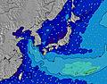 | 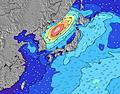 | 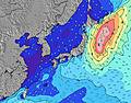 | ||||||||||||
Wave Height (m) Direction Period (s) | ESE 17 | ESE 16 | ESE 17 | ESE 16 | ESE 16 | SE 16 | SE 16 | SE 16 | SE 16 | SSE 16 | SSE 15 | S 15 | SSW 15 | SSW 16 | SSW 15 | SSW 15 | SSW 16 | SSW 16 | SSW 15 |
Wave Graph | |||||||||||||||||||
2437 | 4604 | 6015 | 7616 | 10647 | 13671 | 14717 | 17647 | 19205 | 18867 | 16703 | 6135 | 5316 | 5205 | 4473 | 4580 | 4784 | 3480 | 2324 | |
Wind (km/h) | |||||||||||||||||||
Wind State on-shore cross-onshore cross-shore cross-offshore off-shore glassy | cross | cross-on | on | glassy | cross | cross | cross-off | cross | cross | cross | cross | cross-on | cross | cross | cross-on | cross | cross | cross-on | cross |
High Tide | 9:03AM1.58m | 9:19PM1.69m | 9:59AM1.47m | 9:52PM1.64m | 11:18AM1.36m | 10:35PM1.58m | 1:18PM1.32m | 11:38PM1.53m | 3:21PM1.41m | 1:11AM1.52m | 4:29PM1.55m | 2:42AM1.58m | |||||||
Low Tide | 3:01AM0.57m | 3:03PM0.60m | 3:47AM0.54m | 3:40PM0.78m | 4:44AM0.52m | 4:27PM0.97m | 6:00AM0.50m | 5:43PM1.14m | 7:33AM0.43m | 7:55PM1.22m | 8:57AM0.31m | 9:34PM1.16m | |||||||
— | 5:16 | — | — | 5:16 | — | — | 5:16 | — | — | 5:18 | — | — | 5:18 | — | — | 5:18 | — | — | |
7:00 | — | 7:00 | — | — | 6:59 | — | — | 6:59 | — | — | 6:58 | — | — | 6:57 | — | — | 6:55 | — | |
mm | 4 | — | 1 | — | — | — | — | 1 | 5 | 6 | 1 | — | 3 | 7 | 10 | 14 | 5 | 4 | 6 |
Temp °C | 27 | 28 | 29 | 26 | 30 | 31 | 27 | 30 | 29 | 27 | 30 | 30 | 27 | 27 | 27 | 26 | 27 | 28 | 26 |
Feels °C | 32 | 32 | 32 | 30 | 31 | 33 | 29 | 30 | 31 | 29 | 30 | 30 | 30 | 30 | 29 | 28 | 29 | 30 | 27 |
Swell 1 Height (m) Direction Period (s) | ESE 17 | ESE 16 | ESE 17 | ESE 16 | ESE 16 | SE 16 | SE 16 | SE 16 | SE 16 | SSE 16 | SSE 16 | S 15 | SSW 15 | SSW 16 | SSW 15 | SSW 15 | SSW 16 | SSW 16 | SSW 15 |
2437 | 4604 | 6015 | 7616 | 10647 | 13671 | 14717 | 17647 | 19205 | 15437 | 13303 | 6135 | 5316 | 5205 | 4473 | 4580 | 4784 | 3480 | 2324 | |
Swell 2 Height (m) Direction Period (s) | SE 12 | ESE 19 | — | — | — | — | — | — | — | — | — | — | SE 10 | — | — | — | E 12 | E 13 | ESE 13 |
6 | 1802 | — | — | — | — | — | — | — | — | — | — | 1151 | — | — | — | 110 | 171 | 229 | |
Swell 3 Height (m) Direction Period (s) | — | — | — | — | — | — | — | — | — | — | — | — | — | — | — | — | — | — | — |
— | — | — | — | — | — | — | — | — | — | — | — | — | — | — | — | — | — | — | |
Wind waves Height (m) Direction Period (s) | ESE 7 | E 8 | — | — | — | — | — | — | — | SSE 16 | SSE 15 | ESE 10 | ESE 9 | ESE 9 | ESE 9 | SE 9 | ESE 9 | ESE 9 | ESE 8 |
189 | 603 | — | — | — | — | — | — | — | 18867 | 16703 | 1908 | 1352 | 997 | 1198 | 1405 | 1244 | 1145 | 956 | |
Nearest Offshore or Glassy | |||||||||||||||||||
Distance (km) | 19 | 19 | 19 | 0 | 22 | 245 | 0 | 503 | 459 | 459 | 459 | 459 | 459 | 459 | 475 | 459 | 510 | 459 | 1037 |
Best forecast wave conditions in Shikoku | |||||||||||||||||||
Best forecast wave conditions in Japan | |||||||||||||||||||
Header Global | |||||||||||||||||||
- Map Icons:
 Break
Break Live Wave Height (m)
 Live Wind Speed (km/h)
 Surf Rating (10 Max)
 Ocean Swells (m)
- Wind Speed (km/h)
Latest Updates


FREE! Surf-Forecast.com widget for your website
The surf report / weather widget below is available to embed on third party websites free of charge and provides a summary of our Asakawa surf forecast. Simply grab the html code snippet that we provide and paste it into your own site. You can choose your preferred language and metric/imperial units for the surf forecast feed to suit users of your site. Click here to get the code.
Information about the Asakawa Surf forecast
The above surf forecast table for Asakawa provides essential information for determining whether the surfing conditions will be good over the next 16 days. A general guide to surfing at Asakawa can be found by selecting the local surf guide option on the grey menu. Our Asakawa surf forecast is unique since it includes wave energy (power) that defines the real feel of the surf rather than just the height or the period. If you surf the same spot (Asakawa) regularly then make a mental note of the wave energy from the surf forecast table each time you go. Very soon you may start to choose your surf days based on the wave energy alone combined with our forecast of favourable offshore wind conditions. Our star ratings will help here and of course you will also find the usual wave height and period predictions on our surf forecasts as well as a full break down of the swell components under our advanced users option (to reveal that, click the little Einstein character under the tide times).
Further information to help with frequently asked questions about our surf forecast for Asakawa may be found under the help tab on the top menu and also by moving your mouse over the question marks on the surf forecast table itself. Please always bear in mind that the forecast is for near-shore open water and local factors at each surf break influence the actual breaking wave height, such as the beach / reef profile, water depths offshore and shelter.
Are you planning a holiday in Shikoku? If you are looking for accommodation near Asakawa, camping, hotels and holiday cottages in Shikoku, consider staying in Anan which is 41 km (25 miles) away. Other places in and around Shikoku where you can find information about places to rent, and car hire include Muroto which is 44 km (27 miles) away, Komatsushima, Aki and Kamojima.
 Nearest