

Surf Forecasts:

Uchizuma surf forecast from 2 Aug 2026:
- Best quality surf: Tuesday 4 Aug, 6PM (local time) - 13ft (4.0m), 17s period, ESE swell with onshore winds.
- Most powerful swell: Thursday 6 Aug, 3PM (local time) - 23ft (7.0m), 17s period, SE swell with 27,329 kJ wave energy.
- Next surfable swell (1★+): Monday 3 Aug, 3AM (local time) - 4.5ft (1.4m), 16s period with ESE swell.
Best Forecast Surf Conditions for Uchizuma this week:
The surf forecast for Uchizuma over the next 16 days: The first swell (rated 1 star or higher) is forecast to arrive on Monday (Aug 03) at 3AM. The primary swell is predicted to be 1.4m and 16s period with a secondary swell of 0.3m and 10s. The wind is predicted to be cross-offshore as the swell arrives.
The most powerful waves expected at Uchizuma in the next 16 days are 7.0m 17s and forecast to arrive on Thursday (Aug 06) at 3PM. Winds are predicted to be cross-shore at the time the swell arrives. The largest open ocean swell (not directed at the beach) is 0.6m 3s period and expected on Monday (Aug 03) at 3AM.
| Wave Type | Time (JST) & Date | Wave Height & Period |
|---|---|---|
| Next good surf (1 star+) | 3AM (Mon 3rd Aug) | 4.5ft (1.4m) 16s |
| Best Surf | 6PM (Tue 4th Aug) | 13ft (4.0m) 17s |
| Most Powerful | 3PM (Thu 6th Aug) | 23ft (7.0m) 17s |
Table - best surf conditions forecast for Uchizuma over the next 16 days.
The Lowdown
Alright, grab your wettie and listen up, Rusty here. I’ve been staring at the charts for Uchizuma for the next couple of weeks. The short version? We’ve got one hell of a stormy, oversized pulse coming down the pipe, and then it fades out into a long, quiet stretch.
The first few days of the run are a waste of time. Swell is building, but it’s all onshore junk and the conditions are marginal at best. We’re looking at a pretty gnarly system pushing through.
The real story is Wednesday, August 5th. That’s when things get huge. The swell direction is from the SE, which is not Uchizuma’s optimum (SE is actually what it wants to see, so that’s good), but it’s going to be way too much juice. The wave energy is off the charts – we’re talking 16068 by the afternoon, man. That’s a serious amount of water moving. This is 14.8ft to 18ft of raw power. The wind is light and cross, but that doesn't matter much when it's that big. This is strictly for the experts, if anyone is even getting out. It will be a washing machine. If you’re not an absolute charger, stay on the beach and watch.
Thursday, August 6th, isn’t any better for the average surfer. The swell peaks overnight and into the morning, hitting 21.3ft to 23ft. The energy reading is over 29000, which is insane. There’s a chance the morning has some clean conditions with a cross-offshore wind, but honestly, this is beyond a surf forecast – it’s a survival forecast.
We ride this massive swell down through the weekend, but it's coming with a bunch of wind and stormy conditions. It's not until the middle of next week that things start to settle. From August 10th, the size drops, but so does the quality. We get into a period of messy, cross-onshore slop. There are a few days of pure chop that aren't worth paddling out for.
The standout, or what's left of it, comes much later. Around Thursday, August 13th, the ocean finally exhales. We get tiny, glassy conditions – 3.6ft of S swell with zero wind. The energy is weak, but the surface will be clean as a whistle. It’s almost a shame that such pristine conditions are going to waste on such small waves. It's a decent time for a beginner to get their first couple of rides, but for the rest of us, it's a longboard and a prayer.
After that, it’s just a slow fade. We get a little pulse of 5.9ft ESE swell on the 17th and 18th with light winds, which could be fun on a high-performance shortboard, but it’s not going to be epic.
The bottom line? The first half of the forecast is a story about too much swell, and the second half is about not enough. There’s one brief window around August 16th and 17th with clean conditions and some rideable waist-to-chest high waves, which is likely the most practical time to get out. The 13th looks pretty, but it’s tiny.
Stay safe out there.
Short Range ForecastLight rain (total 2mm), mostly falling on Mon afternoon. Warm (max 31°C on Mon morning, min 26°C on Mon night). Wind will be generally light. | Days 5-7 Weather SummaryHeavy rain (total 46mm), heaviest during Sat afternoon. Warm (max 31°C on Thu morning, min 26°C on Wed night). Wind will be generally light. | ||||||||||||||||||
Monday 3 | Tuesday 4 | Wednesday 5 | Thursday 6 | Friday 7 | Saturday 8 | ||||||||||||||
Night | AM | PM | Night | AM | PM | Night | AM | PM | Night | AM | PM | Night | AM | PM | Night | AM | PM | Night | |
Swell Height Map |  |  |  |  | 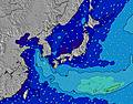 |  | 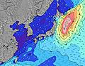 | ||||||||||||
Wave Height (m) Direction Period (s) | ESE 15 | ESE 16 | ESE 16 | ESE 17 | ESE 16 | ESE 17 | ESE 17 | SE 17 | SE 17 | SE 17 | SE 18 | SE 17 | SSE 17 | SSE 16 | SSE 15 | S 16 | S 16 | SSW 16 | SSW 16 |
Wave Graph | |||||||||||||||||||
621 | 1223 | 1393 | 3876 | 4324 | 6015 | 9208 | 12450 | 16068 | 20477 | 26830 | 27329 | 25528 | 24270 | 16466 | 8899 | 8042 | 6833 | 7085 | |
Wind (km/h) | |||||||||||||||||||
Wind State on-shore cross-onshore cross-shore cross-offshore off-shore glassy | off | cross-on | on | cross-on | on | on | glassy | cross | cross | cross-off | cross-off | cross | cross-off | cross | cross | cross | cross | cross | cross |
High Tide | 8:17AM1.67m | 8:51PM1.72m | 9:03AM1.58m | 9:19PM1.69m | 9:59AM1.47m | 9:52PM1.64m | 11:18AM1.36m | 10:35PM1.58m | 1:18PM1.32m | 11:38PM1.53m | 3:21PM1.41m | 1:11AM1.52m | |||||||
Low Tide | 2:22AM0.61m | 2:31PM0.44m | 3:01AM0.57m | 3:03PM0.60m | 3:47AM0.54m | 3:40PM0.78m | 4:44AM0.52m | 4:27PM0.97m | 6:00AM0.50m | 5:43PM1.14m | 7:33AM0.43m | 7:55PM1.22m | |||||||
— | 5:15 | — | — | 5:16 | — | — | 5:16 | — | — | 5:16 | — | — | 5:18 | — | — | 5:18 | — | — | |
7:01 | — | 7:00 | — | — | 7:00 | — | — | 6:59 | — | — | 6:59 | — | — | 6:58 | — | — | 6:57 | — | |
mm | — | — | 1 | — | 1 | — | — | — | — | — | — | 1 | 2 | 4 | 4 | 5 | 13 | 17 | 12 |
Temp °C | 30 | 31 | 29 | 27 | 29 | 29 | 26 | 30 | 30 | 27 | 31 | 31 | 28 | 29 | 28 | 27 | 26 | 26 | 26 |
Feels °C | 34 | 35 | 33 | 31 | 33 | 32 | 29 | 32 | 32 | 30 | 31 | 31 | 29 | 30 | 29 | 29 | 28 | 27 | 27 |
Swell 1 Height (m) Direction Period (s) | ESE 15 | ESE 16 | ESE 16 | ESE 17 | ESE 16 | ESE 17 | ESE 17 | SE 17 | SE 17 | SE 17 | SE 18 | SE 17 | SSE 17 | SSE 16 | SSE 15 | S 16 | S 16 | SSW 16 | SSW 16 |
621 | 1223 | 1393 | 2437 | 4324 | 6015 | 9208 | 12450 | 16068 | 20477 | 26830 | 27329 | 25528 | 19992 | 16466 | 8899 | 8042 | 6833 | 7085 | |
Swell 2 Height (m) Direction Period (s) | SE 10 | SE 10 | S 8 | ESE 7 | — | — | — | — | — | — | — | — | — | — | — | — | — | — | — |
15 | 15 | 5 | 200 | — | — | — | — | — | — | — | — | — | — | — | — | — | — | — | |
Swell 3 Height (m) Direction Period (s) | SSW 8 | S 8 | S 8 | SE 12 | — | — | — | — | — | — | — | — | — | — | — | — | — | — | — |
6 | 5 | 4 | 6 | — | — | — | — | — | — | — | — | — | — | — | — | — | — | — | |
Wind waves Height (m) Direction Period (s) | — | E 4 | ESE 6 | ESE 17 | E 9 | E 9 | — | — | — | — | — | E 10 | — | SSE 16 | ESE 10 | ESE 10 | ESE 10 | ESE 9 | ESE 9 |
— | 20 | 122 | 3876 | 783 | 715 | — | — | — | — | — | 2184 | — | 24270 | 3078 | 2036 | 1672 | 1731 | 1172 | |
Nearest Offshore or Glassy | |||||||||||||||||||
Distance (km) | 0 | 21 | 43 | 19 | 19 | 999 | 1 | 43 | 523 | 57 | 444 | 458 | 402 | 509 | 458 | 458 | 509 | 458 | 503 |
Best forecast wave conditions in Shikoku | |||||||||||||||||||
Best forecast wave conditions in Japan | |||||||||||||||||||
Header Global | |||||||||||||||||||
- Map Icons:
 Break
Break Live Wave Height (m)
 Live Wind Speed (km/h)
 Surf Rating (10 Max)
 Ocean Swells (m)
- Wind Speed (km/h)
Latest Updates


FREE! Surf-Forecast.com widget for your website
The surf report / weather widget below is available to embed on third party websites free of charge and provides a summary of our Uchizuma surf forecast. Simply grab the html code snippet that we provide and paste it into your own site. You can choose your preferred language and metric/imperial units for the surf forecast feed to suit users of your site. Click here to get the code.
Information about the Uchizuma Surf forecast
The above surf forecast table for Uchizuma provides essential information for determining whether the surfing conditions will be good over the next 16 days. A general guide to surfing at Uchizuma can be found by selecting the local surf guide option on the grey menu. Our Uchizuma surf forecast is unique since it includes wave energy (power) that defines the real feel of the surf rather than just the height or the period. If you surf the same spot (Uchizuma) regularly then make a mental note of the wave energy from the surf forecast table each time you go. Very soon you may start to choose your surf days based on the wave energy alone combined with our forecast of favourable offshore wind conditions. Our star ratings will help here and of course you will also find the usual wave height and period predictions on our surf forecasts as well as a full break down of the swell components under our advanced users option (to reveal that, click the little Einstein character under the tide times).
Further information to help with frequently asked questions about our surf forecast for Uchizuma may be found under the help tab on the top menu and also by moving your mouse over the question marks on the surf forecast table itself. Please always bear in mind that the forecast is for near-shore open water and local factors at each surf break influence the actual breaking wave height, such as the beach / reef profile, water depths offshore and shelter.
Are you planning a holiday in Shikoku? If you are looking for accommodation near Uchizuma, camping, hotels and holiday cottages in Shikoku, consider staying in Anan which is 40 km (25 miles) away. Other places in and around Shikoku where you can find information about places to rent, and car hire include Muroto which is 45 km (28 miles) away, Komatsushima, Aki and Kamojima.
 Nearest