

Surf Forecasts:

Hashikui Bay surf forecast from 10 Jul 2026:
- Best quality surf: Saturday 11 Jul, 6AM (local time) - 11ft (3.5m), 17s period, S swell with offshore winds.
- Most powerful swell: Saturday 11 Jul, 6PM (local time) - 11ft (3.5m), 17s period, S swell with 7,083 kJ wave energy.
- Next surfable swell (1★+): Saturday 11 Jul, 6AM (local time) - 11ft (3.5m), 17s period with S swell.
Best Forecast Surf Conditions for Hashikui Bay this week:
The surf forecast for Hashikui Bay over the next 16 days: The first swell (rated 1 star or higher) is forecast to arrive on Saturday (Jul 11) at 6AM. The primary swell is predicted to be 3.5m and 17s period. The wind is predicted to be offshore as the swell arrives.
The most powerful waves expected at Hashikui Bay in the next 16 days are 3.5m 17s and forecast to arrive on Saturday (Jul 11) at 6PM. Winds are predicted to be cross-offshore at the time the swell arrives. The largest open ocean swell (not directed at the beach) is 0.6m 4s period and expected on Monday (Jul 13) at 3AM.
| Wave Type | Time (JST) & Date | Wave Height & Period |
|---|---|---|
| Next good surf (1 star+) | 6AM (Sat 11th Jul) | 11ft (3.5m) 17s |
| Best Surf | 6AM (Sat 11th Jul) | 11ft (3.5m) 17s |
| Most Powerful | 6PM (Sat 11th Jul) | 11ft (3.5m) 17s |
Table - best surf conditions forecast for Hashikui Bay over the next 16 days.
Alright, we’ve got a big, heavy swell train aimed at Hashikui Bay, but you’ll need to wait for it. The first few days are flat, so don’t even bother until Saturday, July 11th—that’s when the action starts.
Saturday morning, July 11th, brings a solid 12ft swell from the south, with a very long 17-second period. The energy is pumping at 7075 (strong), and the wind is a light cross-off from the SSE, keeping the surface clean. This is expert-only territory—that size and period means powerful, walled-up waves. The reef will handle the long-period groundswell well, but it’s not for the timid. Water temp is about average for the time of year, and crowds are possible, so be ready.
Saturday afternoon holds similar size, but the energy dips a bit to 6486, and the wind swings more southerly. Still solid, but the tide might be a factor.
Sunday morning, July 12th, is the pick of the first week. The swell drops to 10ft from the SSW, period still a long 16 seconds, with glassy conditions and a light SE breeze. The energy is strong at 4022, and the clean, offshore-influenced wind will have those waves peeling perfectly. This is the best session for experienced surfers.
Sunday afternoon gets a little dicey with a risk of thunderstorms and a cross-shore wind, so quality drops. By Monday, the swell fades fast, and from Tuesday onward, we’re looking at tiny, weak waves—2ft to 3ft range—with very low energy (around 59 to 189). It’s a long, flat stretch from July 14th through the 22nd, with only a few small, glassy moments on the 22nd afternoon that aren’t really worth the paddle.
Then comes the big one. On Thursday, July 24th, the forecast shows a monster 28ft swell from the SSE, with a 14-second period, and the energy is off the charts at 44406. That’s massive. But it’s predicted to be too big for this reef break, and the wind is cross-onshore from the NNW. This is a dangerous, messy, and extreme setup. Only absolute experts should even consider it, and even then, it’s a gamble. The morning of the 23rd also has a solid 10ft to 12ft swell, but with onshore winds and marginal tide, it’s not the best window.
After that, the swell drops quick, and the wind stays onshore, so the last few days are a total washout.
The standout is Sunday morning, July 12th, for the cleanest, most powerful, and manageable waves. If you’re an expert, Saturday the 11th morning is also a ripper. The late-week swell on the 24th is a spectacle, but it’s more for watching than surfing.
Rusty
Short Range ForecastLight rain (total 6mm), mostly falling on Sun afternoon. Warm (max 30°C on Mon morning, min 24°C on Fri night). Wind will be generally light. | Days 5-7 Weather SummaryMostly dry. Warm (max 31°C on Tue morning, min 25°C on Wed night). Wind will be generally light. | ||||||||||||||||||||
Saturday 11 | Sunday 12 | Monday 13 | Tuesday 14 | Wednesday 15 | Thursday 16 | Fri 17 | |||||||||||||||
Night | AM | PM | Night | AM | PM | Night | AM | PM | Night | AM | PM | Night | AM | PM | Night | AM | PM | Night | AM | PM | |
Swell Height Map |  |  |  |  | 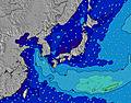 | 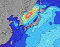 | 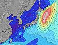 | 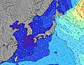 | |||||||||||||
Wave Height (m) Direction Period (s) | S 16 | S 17 | S 17 | S 16 | SSW 16 | SSW 14 | SSW 13 | SSW 12 | SSW 11 | S 11 | SSW 10 | SSW 10 | SSW 9 | SSW 9 | S 9 | SE 10 | S 8 | SSW 8 | SSW 8 | SE 10 | SE 10 |
Wave Graph | |||||||||||||||||||||
6176 | 7075 | 6486 | 5933 | 4014 | 2221 | 1092 | 569 | 438 | 286 | 167 | 128 | 115 | 64 | 101 | 40 | 34 | 22 | 21 | 14 | 14 | |
Wind (km/h) | |||||||||||||||||||||
Wind State on-shore cross-onshore cross-shore cross-offshore off-shore glassy | off | cross-off | cross-off | off | glassy | cross | glassy | glassy | glassy | cross-on | on | glassy | cross-off | cross-off | cross-off | cross-off | cross-off | cross-off | off | cross-off | cross-off |
High Tide | 2:09AM1.64m | 4:44PM1.63m | 3:07AM1.70m | 5:27PM1.72m | 3:59AM1.77m | 6:04PM1.79m | 4:46AM1.83m | 6:38PM1.84m | 5:30AM1.88m | 7:09PM1.86m | 6:12AM1.90m | 7:39PM1.86m | 6:54AM1.90m | ||||||||
Low Tide | 9:31AM0.39m | 9:49PM1.19m | 10:20AM0.27m | 10:41PM1.15m | 11:04AM0.18m | 11:23PM1.09m | 11:44AM0.12m | 00:01AM1.02m | 12:22PM0.11m | 00:38AM0.95m | 12:58PM0.15m | 1:13AM0.88m | 1:33PM0.23m | ||||||||
— | 4:58 | — | — | 4:58 | — | — | 5:00 | — | — | 5:01 | — | — | 5:01 | — | — | 5:01 | — | — | 5:01 | — | |
7:15 | — | 7:14 | — | — | 7:14 | — | — | 7:14 | — | — | 7:13 | — | — | 7:13 | — | — | 7:13 | — | — | 7:12 | |
mm | — | — | — | — | — | 4 | 2 | — | — | — | — | — | — | — | — | — | — | — | — | — | — |
Temp °C | 25 | 26 | 26 | 25 | 29 | 29 | 26 | 30 | 29 | 28 | 31 | 30 | 26 | 28 | 27 | 26 | 28 | 27 | 26 | 29 | 29 |
Feels °C | 29 | 29 | 28 | 29 | 33 | 34 | 31 | 34 | 34 | 33 | 35 | 35 | 30 | 32 | 31 | 30 | 32 | 30 | 30 | 32 | 32 |
Swell 1 Height (m) Direction Period (s) | S 16 | S 17 | S 17 | S 16 | SSW 16 | SSW 14 | SSW 13 | SSW 12 | SSW 11 | S 11 | SSW 10 | SSW 10 | SSW 9 | SSW 9 | SE 11 | SSW 8 | S 8 | SSW 8 | SSW 8 | SSW 8 | SSW 8 |
6176 | 7075 | 6486 | 5933 | 4014 | 2221 | 1092 | 569 | 438 | 286 | 167 | 128 | 115 | 64 | 29 | 40 | 34 | 22 | 21 | 11 | 11 | |
Swell 2 Height (m) Direction Period (s) | — | — | — | — | SE 15 | — | SE 11 | SE 10 | SE 10 | SE 12 | SE 10 | SE 12 | SE 12 | SE 11 | SE 11 | SE 10 | SE 10 | SE 10 | SE 10 | SE 10 | SE 10 |
— | — | — | — | 8 | — | 29 | 17 | 17 | 21 | 15 | 22 | 21 | 18 | 18 | 27 | 17 | 15 | 15 | 14 | 14 | |
Swell 3 Height (m) Direction Period (s) | — | — | — | — | — | — | — | SE 13 | SE 13 | — | SE 12 | SE 12 | — | — | S 8 | SE 10 | ESE 9 | ESE 9 | E 9 | E 10 | E 9 |
— | — | — | — | — | — | — | 7 | 7 | — | 6 | 6 | — | — | 1 | 28 | 8 | 8 | 2 | 7 | 2 | |
Wind waves Height (m) Direction Period (s) | — | — | — | — | — | — | — | — | — | — | NNE 3 | NE 3 | — | SSE 3 | S 9 | S 3 | SSE 2 | S 3 | SSE 3 | S 3 | S 3 |
— | — | — | — | — | — | — | — | — | — | 1 | 2 | — | 2 | 101 | 5 | 1 | 5 | 3 | 1 | 2 | |
Nearest Offshore or Glassy | |||||||||||||||||||||
Distance (km) | 0 | 0 | 49 | 0 | 0 | 33 | 0 | 0 | 0 | 3 | 3 | 0 | 0 | 0 | 0 | 0 | 0 | 49 | 19 | 49 | 49 |
Best forecast wave conditions in Shikoku | |||||||||||||||||||||
Best forecast wave conditions in Japan | |||||||||||||||||||||
Header Global | |||||||||||||||||||||
- Map Icons:
 Break
Break Live Wave Height (m)
 Live Wind Speed (km/h)
 Surf Rating (10 Max)
 Ocean Swells (m)
- Wind Speed (km/h)


FREE! Surf-Forecast.com widget for your website
The surf report / weather widget below is available to embed on third party websites free of charge and provides a summary of our Hashikui Bay surf forecast. Simply grab the html code snippet that we provide and paste it into your own site. You can choose your preferred language and metric/imperial units for the surf forecast feed to suit users of your site. Click here to get the code.
Information about the Hashikui Bay Surf forecast
The above surf forecast table for Hashikui Bay provides essential information for determining whether the surfing conditions will be good over the next 16 days. A general guide to surfing at Hashikui Bay can be found by selecting the local surf guide option on the grey menu. Our Hashikui Bay surf forecast is unique since it includes wave energy (power) that defines the real feel of the surf rather than just the height or the period. If you surf the same spot (Hashikui Bay) regularly then make a mental note of the wave energy from the surf forecast table each time you go. Very soon you may start to choose your surf days based on the wave energy alone combined with our forecast of favourable offshore wind conditions. Our star ratings will help here and of course you will also find the usual wave height and period predictions on our surf forecasts as well as a full break down of the swell components under our advanced users option (to reveal that, click the little Einstein character under the tide times).
Further information to help with frequently asked questions about our surf forecast for Hashikui Bay may be found under the help tab on the top menu and also by moving your mouse over the question marks on the surf forecast table itself. Please always bear in mind that the forecast is for near-shore open water and local factors at each surf break influence the actual breaking wave height, such as the beach / reef profile, water depths offshore and shelter.
Hashikui Bay is 23 km (14 miles) from Anan. If you plan a holiday in Shikoku, look for hotels and other accommodation in Anan. Anan has rooms for a wide range of budgets as well as car hire and transport links.
 Nearest