

Surf Forecasts:

Wonthaggi surf forecast from 2 Aug 2026:
- Best quality surf: Friday 7 Aug, 7PM (local time) - 5ft (1.5m), 14s period, WSW swell with cross-offshore winds.
- Most powerful swell: Monday 10 Aug, 10AM (local time) - 20ft (6.0m), 13s period, WSW swell with 13,104 kJ wave energy.
- Next surfable swell (1★+): Friday 7 Aug, 7PM (local time) - 5ft (1.5m), 14s period with WSW swell.
Best Forecast Surf Conditions for Wonthaggi this week:
The surf forecast for Wonthaggi over the next 16 days: The first swell (rated 1 star or higher) is forecast to arrive on Friday (Aug 07) at 7PM. The primary swell is predicted to be 1.5m and 14s period with a secondary swell of 1.1m and 17s. The wind is predicted to be cross-offshore as the swell arrives.
The most powerful waves expected at Wonthaggi in the next 16 days are 6.0m 13s and forecast to arrive on Monday (Aug 10) at 10AM. Winds are predicted to be cross-onshore at the time the swell arrives. The largest open ocean swell (not directed at the beach) is 1.9m 6s period and expected on Sunday (Aug 09) at 1PM.
| Wave Type | Time (AEST) & Date | Wave Height & Period |
|---|---|---|
| Next good surf (1 star+) | 7PM (Fri 7th Aug) | 5ft (1.5m) 14s |
| Best Surf | 7PM (Fri 7th Aug) | 5ft (1.5m) 14s |
| Most Powerful | 10AM (Mon 10th Aug) | 20ft (6.0m) 13s |
Table - best surf conditions forecast for Wonthaggi over the next 16 days.
The Lowdown
G’day, it’s Rusty here. Let’s cut straight to it. The next couple of weeks are going to test your patience if you’re chasing waves around Wonthaggi. There’s a real mix of big, raw energy and long flat spells, and you’ll have to pick your moments carefully.
The main story for this period is a lot of swell, but a lot of it is either too messy, too blown out, or simply too big for this stretch of coast. The water temp is sitting at 56.3°, which is a touch warmer than usual for this time of year – nothing crazy, but you’ll notice it if you’re used to the mid-winter chill.
The first decent window doesn’t show up until Friday the 7th. Before that, it’s a write-off. Monday the 3rd has a lumpy 5.6ft cross-shore mess, and Tuesday the 4th sees a raw 6.9ft to 7.9ft bump with onshore winds – not worth your time. Wednesday and Thursday are small and chopped up, with the swell dropping to under 3ft.
So, Friday morning the 7th: there’s a 4.9ft west-southwest swell with a 16-second period, but the wind is cross-on and it’s a bit choppy. The afternoon is better – the breeze drops to a light 6 mph and the swell cleans up a little. The combined energy is strong at 1576, but it’s still only a marginal call. Saturday the 8th has a similar 4.9ft swell, and the morning looks cleaner with a light cross-offshore wind. It’s inconsistent, so you’ll be waiting between sets, but that long-period groundswell (16 seconds) means some proper lines will come through. It’s not epic, but it’s the best of a slow start.
Now, here’s where things get interesting. Sunday the 9th starts with a howling 28 mph north wind, but it’s cross-offshore and the surf is clean. By the afternoon, the swell jumps to 7.2ft with a 13-second period and the energy is pumping at 2143. The wind eases to 22 mph, still cross-off, and it’s clean – this is a proper stormy session for the experienced crew. The setup is more for confident surfers; the beach break will be handling a lot of water.
Then Monday the 10th is when it gets wild. The swell explodes to a massive 19.7ft with a 16-second period. The combined energy is off the charts at 18410 – that’s some serious ocean. The wind is moderate and cross-on, so it’s going to be a messy, heaving beast. This is way too big for this break. It’s a full-on expert-only situation, and even then, it’s going to be a washing machine. The same goes for Tuesday the 11th with an 11.5ft swell and fresh cross-shore winds. It’s a wall of whitewater, not a surfable wave.
Wednesday the 12th drops a bit to 6.6ft to 8.2ft, but the winds are fresh and onshore, making it lumpy and poor. Thursday the 13th brings another massive pulse – 16.4ft with a 15-second period. The winds are light but cross-on, making it a huge, lumpy mess. Again, this is not a paddle-out situation. This is the kind of day where the beach break is just a closeout bowl of chaos.
Friday the 14th still has a big 11.5ft to 9.8ft swell, with light winds but onshore tendencies. It’s still too big and messy for any real fun. The energy is still very strong, but it’s not doing anyone any favors.
After that big run, things start to settle. Saturday the 15th has a 6.2ft southwest swell with a 16-second period, and the morning looks magic – almost no wind (3 mph) and light cross-shore. It’s clean, and with that long period, there’s some proper push. This is a standout, but it’s inconsistent. The crowd factor is possible so get in early. This is the day to be out there if you can wait it out.
Sunday the 16th is a step back – onshore winds and a 5.2ft swell that’s a little lumpy. Not bad, but not great. Monday the 17th is similar, small and onshore.
The final call for the window is Tuesday the 18th. There’s a 6.6ft to 6.9ft west-southwest swell with an 11-second period, and the wind is light and offshore in the morning. It’s clean and has some energy to it (1780 in the afternoon), but the shorter period means it might be a bit walled up at the beach. Still, it’s a decent way to end the run.
So, what’s the best on offer? It’s a toss-up between Saturday the 8th for a cleaner, more traditional session, and Saturday the 15th when the ocean goes quiet and the long-period groundswell lines up with almost no wind. If you’re up for
Short Range ForecastHeavy rain (total 34mm), heaviest during Tue morning. Very mild (max 12°C on Mon afternoon, min 8°C on Mon night). Winds decreasing (fresh winds from the WNW on Mon morning, light winds from the SSW by Tue night). | Days 4-6 Weather SummarySome drizzle, heaviest during Thu night. Very mild (max 15°C on Sat morning, min 9°C on Thu morning). Winds increasing (light winds from the E on Fri afternoon, fresh winds from the NNW by Sat night). | ||||||||||||||||||||
Monday 3 | Tuesday 4 | Wednesday 5 | Thursday 6 | Friday 7 | Saturday 8 | Sunday 9 | |||||||||||||||
AM | PM | Night | AM | PM | Night | AM | PM | Night | AM | PM | Night | AM | PM | Night | AM | PM | Night | AM | PM | Night | |
Swell Height Map |  |  |  | 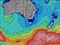 | 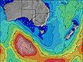 | 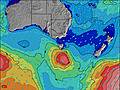 | 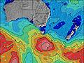 | ||||||||||||||
Wave Height (m) Direction Period (s) | W 10 | SW 16 | SW 14 | WSW 11 | WSW 11 | SW 10 | SW 9 | SW 8 | SW 13 | SW 12 | SW 16 | SW 18 | WSW 16 | WSW 15 | WSW 15 | WSW 16 | SW 16 | WSW 14 | WSW 14 | WNW 13 | W 7 |
Wave Graph | |||||||||||||||||||||
539 | 702 | 743 | 1126 | 1488 | 625 | 406 | 187 | 205 | 149 | 196 | 635 | 1155 | 1001 | 1132 | 1184 | 1018 | 701 | 561 | 1594 | 905 | |
Wind (km/h) | |||||||||||||||||||||
Wind State on-shore cross-onshore cross-shore cross-offshore off-shore glassy | cross | cross-on | cross-on | cross | on | on | cross-on | on | on | cross | cross | cross-on | cross-on | cross-on | cross-off | cross-off | cross | cross-off | cross-off | cross-off | on |
High Tide | 3:05PM2.25m | 3:22AM2.04m | 3:36PM2.26m | 4:04AM2.11m | 4:07PM2.26m | 4:47AM2.16m | 4:40PM2.25m | 5:33AM2.19m | 5:16PM2.23m | 6:23AM2.18m | 5:57PM2.19m | 7:18AM2.14m | 6:45PM2.14m | ||||||||
Low Tide | 9:21PM0.52m | 9:22AM0.50m | 9:55PM0.39m | 10:01AM0.56m | 10:30PM0.28m | 10:41AM0.63m | 11:07PM0.19m | 11:23AM0.72m | 11:49PM0.13m | 12:09PM0.83m | 00:37AM0.11m | 1:01PM0.93m | 1:32AM0.13m | ||||||||
7:18 | — | — | 7:16 | — | — | 7:16 | — | — | 7:15 | — | — | 7:13 | — | — | 7:13 | — | — | 7:11 | — | — | |
— | 5:30 | — | — | 5:30 | — | — | 5:30 | — | — | 5:31 | — | — | 5:32 | — | — | 5:34 | — | — | 5:35 | — | |
mm | 1 | 1 | 8 | 5 | 6 | 8 | 3 | 2 | — | — | — | 1 | — | — | — | — | — | — | — | 1 | 7 |
Temp °C | 11 | 12 | 10 | 8 | 12 | 11 | 12 | 12 | 12 | 10 | 10 | 11 | 12 | 13 | 13 | 15 | 15 | 14 | 11 | 10 | 12 |
Feels °C | 4 | 5 | 4 | 2 | 7 | 8 | 8 | 8 | 7 | 4 | 4 | 8 | 8 | 10 | 10 | 11 | 11 | 8 | 2 | 2 | 5 |
Swell 1 Height (m) Direction Period (s) | SW 14 | SW 16 | SW 14 | WSW 11 | WSW 11 | SW 10 | SW 20 | SW 14 | SW 13 | SW 12 | SW 16 | SW 18 | WSW 16 | WSW 15 | WSW 15 | WSW 16 | SW 16 | WSW 14 | WSW 14 | WSW 16 | WSW 15 |
521 | 702 | 743 | 1126 | 976 | 625 | 186 | 167 | 205 | 149 | 196 | 635 | 1155 | 1001 | 1132 | 1184 | 1018 | 701 | 561 | 330 | 568 | |
Swell 2 Height (m) Direction Period (s) | SW 17 | — | — | — | NNW 4 | SW 21 | SW 14 | SW 19 | SW 18 | SSW 6 | WSW 12 | WSW 11 | WSW 6 | SW 19 | SW 18 | — | NW 4 | NW 4 | SW 18 | SW 16 | SW 20 |
302 | — | — | — | 6 | 111 | 48 | 175 | 154 | 27 | 93 | 103 | 80 | 529 | 80 | — | 9 | 5 | 155 | 219 | 408 | |
Swell 3 Height (m) Direction Period (s) | WSW 18 | — | — | — | — | — | — | SW 10 | — | SW 16 | WSW 20 | WSW 14 | WSW 9 | WSW 6 | SSW 5 | — | — | — | WSW 18 | — | — |
207 | — | — | — | — | — | — | 53 | — | 129 | 38 | 82 | 16 | 46 | 4 | — | — | — | 124 | — | — | |
Wind waves Height (m) Direction Period (s) | W 10 | W 8 | WSW 9 | NW 4 | WSW 11 | — | SW 9 | SW 8 | SW 6 | W 5 | W 5 | W 5 | WSW 9 | — | — | NNW 3 | — | NNW 4 | NW 6 | WNW 13 | W 7 |
539 | 518 | 613 | 45 | 1488 | — | 406 | 187 | 131 | 39 | 37 | 51 | 222 | — | — | 6 | — | 27 | 316 | 1594 | 905 | |
Nearest Offshore or Glassy | |||||||||||||||||||||
Distance (km) | 117 | 103 | 103 | 11 | 16 | 16 | 35 | 107 | 43 | 11 | 11 | 41 | 30 | 7 | 7 | 7 | 7 | 7 | 231 | 109 | 107 |
Best forecast wave conditions in East Coast of Victoria | |||||||||||||||||||||
Best forecast wave conditions in Australia | |||||||||||||||||||||
Header Global | |||||||||||||||||||||
- Map Icons:
 Break
Break Live Wave Height (m)
 Live Wind Speed (km/h)
 Surf Rating (10 Max)
 Ocean Swells (m)
- Wind Speed (km/h)
Latest Updates


FREE! Surf-Forecast.com widget for your website
The surf report / weather widget below is available to embed on third party websites free of charge and provides a summary of our Wonthaggi surf forecast. Simply grab the html code snippet that we provide and paste it into your own site. You can choose your preferred language and metric/imperial units for the surf forecast feed to suit users of your site. Click here to get the code.
Information about the Wonthaggi Surf forecast
The above surf forecast table for Wonthaggi provides essential information for determining whether the surfing conditions will be good over the next 16 days. A general guide to surfing at Wonthaggi can be found by selecting the local surf guide option on the grey menu. Our Wonthaggi surf forecast is unique since it includes wave energy (power) that defines the real feel of the surf rather than just the height or the period. If you surf the same spot (Wonthaggi) regularly then make a mental note of the wave energy from the surf forecast table each time you go. Very soon you may start to choose your surf days based on the wave energy alone combined with our forecast of favourable offshore wind conditions. Our star ratings will help here and of course you will also find the usual wave height and period predictions on our surf forecasts as well as a full break down of the swell components under our advanced users option (to reveal that, click the little Einstein character under the tide times).
Further information to help with frequently asked questions about our surf forecast for Wonthaggi may be found under the help tab on the top menu and also by moving your mouse over the question marks on the surf forecast table itself. Please always bear in mind that the forecast is for near-shore open water and local factors at each surf break influence the actual breaking wave height, such as the beach / reef profile, water depths offshore and shelter.
Wonthaggi is 58 km (36 miles) from Cranbourne. If you plan a holiday in East Coast of Victoria, look for hotels and other accommodation in Cranbourne. Cranbourne has rooms for a wide range of budgets as well as car hire and transport links.
 Nearest