

Surf Forecasts:

Hope Beach surf forecast from 3 Aug 2026:
- Best quality surf: Monday 10 Aug, 7AM (local time) - 5ft (1.5m), 18s period, SSW swell with offshore winds.
- Most powerful swell: Monday 10 Aug, 7AM (local time) - 5ft (1.5m), 18s period, SSW swell with 1,385 kJ wave energy.
- Next surfable swell (1★+): Monday 3 Aug, 7PM (local time) - 2ft (0.6m), 13s period with SSW swell.
Best Forecast Surf Conditions for Hope Beach this week:
The surf forecast for Hope Beach over the next 16 days: The first swell (rated 1 star or higher) is forecast to arrive on Monday (Aug 03) at 7PM. The primary swell is predicted to be 0.6m and 13s period with a secondary swell of 0.4m and 18s. The wind is predicted to be cross-offshore as the swell arrives.
The most powerful waves expected at Hope Beach in the next 16 days are 1.5m 18s and forecast to arrive on Monday (Aug 10) at 7AM. Winds are predicted to be offshore at the time the swell arrives. The largest open ocean swell (not directed at the beach) is 1.5m 5s period and expected on Sunday (Aug 09) at 10AM.
| Wave Type | Time (AEST) & Date | Wave Height & Period |
|---|---|---|
| Next good surf (1 star+) | 7PM (Mon 3rd Aug) | 2ft (0.6m) 13s |
| Best Surf | 7AM (Mon 10th Aug) | 5ft (1.5m) 18s |
| Most Powerful | 7AM (Mon 10th Aug) | 5ft (1.5m) 18s |
Table - best surf conditions forecast for Hope Beach over the next 16 days.
The Lowdown
Alright folks, Rusty here. Let’s take a look at what’s on the menu for the next couple of weeks.
The first few days are a bit of a write-off, to be honest – we’ve got a rough start with poor surf and messy conditions. The wait is worth it, though. The real action kicks off late in the first week and builds into something pretty special.
Looking at the data, the standout window is the 10th of August through to the 15th of August. For a solid all-rounder, Hope Beach on Monday, 10th of August is looking clean. The morning session is the pick: offshore wind from the NNW at 6 mph, with a 4 ft swell from the SSW packing some serious punch – the combined energy is a solid 891 (moderate). The water temperature is sitting at 52°, which is about 1° cooler than normal, so nothing crazy, just a bit fresh for the time of year. That long-period swell (18 seconds) means you’ll get nice, powerful lines with good gaps between sets, perfect for a point or reef setup, though being a beach break, it might wall up a bit. Still, this is the best on offer.
Then, hold onto your board, because Tuesday, 11th of August afternoon comes in hot. We’re looking at a 6 ft swell from the SSW with a 19-second period. The combined energy jumps to 2496 (strong energy). That’s a lot of power. The wind is offshore from the north at 12 mph, keeping things clean. This is excellent surf, but it’s getting into expert territory – over 5 ft and with that kind of energy, it’s not for the beginners. The crowds at Hope Beach are listed as “sometimes”, so you might have some company, but it won’t be a zoo.
There are a few other good days, like the 13th and 14th of August, with similar offshore winds and solid 4 ft to 5 ft SSW swell, but that Tuesday afternoon is the real standout. The 15th of August morning also looks big and clean for the experts with a 7 ft SW swell, but the wind is a bit stronger.
The last few days from the 16th onward drop off again in size and quality, so don’t get your hopes up for the second week.
So, mark your calendar for the 10th and especially the 11th of August. That’s the call.
Rusty.
Short Range ForecastLight rain (total 2mm), mostly falling on Tue afternoon. Very mild (max 12°C on Mon afternoon, min 8°C on Mon night). Wind will be generally light. | Days 4-6 Weather SummarySome drizzle, heaviest during Thu afternoon. Very mild (max 14°C on Sat afternoon, min 5°C on Fri night). Winds increasing (calm on Thu morning, fresh winds from the N by Sat night). | ||||||||||||||||||||
Monday 3 | Tuesday 4 | Wednesday 5 | Thursday 6 | Friday 7 | Saturday 8 | Sunday 9 | |||||||||||||||
AM | PM | Night | AM | PM | Night | AM | PM | Night | AM | PM | Night | AM | PM | Night | AM | PM | Night | AM | PM | Night | |
Swell Height Map |  |  |  | 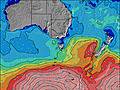 | 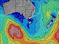 | 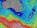 | 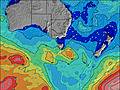 | ||||||||||||||
Wave Height (m) Direction Period (s) | SSW 14 | SSW 13 | SSW 17 | SSW 12 | SSE 9 | SSW 20 | S 19 | SSW 19 | ESE 10 | ESE 9 | ESE 8 | SSW 18 | SSW 16 | SSW 15 | SSW 18 | SSW 16 | SSW 16 | SSW 14 | SSW 14 | S 17 | SSW 19 |
Wave Graph | |||||||||||||||||||||
207 | 139 | 101 | 83 | 129 | 135 | 192 | 115 | 179 | 188 | 94 | 249 | 457 | 381 | 243 | 480 | 446 | 186 | 73 | 154 | 804 | |
Wind (km/h) | |||||||||||||||||||||
Wind State on-shore cross-onshore cross-shore cross-offshore off-shore glassy | cross-off | glassy | cross-off | cross-off | cross-on | cross-off | cross | cross-on | cross-off | cross-off | off | cross | off | cross | off | cross-off | cross-off | cross-off | cross-off | cross-off | cross-off |
High Tide | 10:44AM0.52m | 10:07PM0.54m | 11:21AM0.57m | 11:24PM0.49m | 12:01PM0.63m | 00:48AM0.46m | 12:46PM0.68m | 2:14AM0.44m | 1:34PM0.72m | 3:37AM0.42m | 2:25PM0.76m | 4:53AM0.42m | 3:18PM0.78m | ||||||||
Low Tide | 4:19PM0.31m | 4:42AM0.19m | 5:39PM0.26m | 5:21AM0.23m | 6:53PM0.20m | 6:04AM0.27m | 8:02PM0.13m | 6:50AM0.30m | 9:07PM0.07m | 7:37AM0.33m | 10:10PM0.02m | 8:25AM0.35m | 11:10PM-0.01m | ||||||||
7:20 | — | — | 7:18 | — | — | 7:18 | — | — | 7:16 | — | — | 7:15 | — | — | 7:13 | — | — | 7:13 | — | — | |
— | 5:12 | — | — | 5:13 | — | — | 5:14 | — | — | 5:15 | — | — | 5:15 | — | — | 5:16 | — | — | 5:17 | — | |
mm | — | — | — | — | 2 | — | — | — | — | — | 1 | — | — | — | — | — | — | — | — | — | 1 |
Temp °C | 11 | 12 | 9 | 10 | 11 | 10 | 12 | 12 | 11 | 12 | 11 | 10 | 9 | 11 | 8 | 12 | 14 | 11 | 11 | 11 | 10 |
Feels °C | 6 | 10 | 7 | 6 | 6 | 7 | 8 | 7 | 6 | 10 | 8 | 2 | 6 | 8 | 4 | 8 | 8 | 5 | 4 | 4 | 3 |
Swell 1 Height (m) Direction Period (s) | SSW 14 | SSW 13 | SSW 13 | SSW 12 | SSE 9 | SE 8 | ESE 8 | ESE 8 | ESE 10 | ESE 9 | ESE 8 | SSW 6 | SSW 16 | SSW 15 | SSW 18 | SSW 16 | SSW 16 | SSW 14 | SSW 14 | S 17 | SSW 19 |
207 | 139 | 98 | 83 | 129 | 129 | 105 | 103 | 179 | 188 | 94 | 60 | 457 | 381 | 243 | 480 | 446 | 186 | 73 | 154 | 804 | |
Swell 2 Height (m) Direction Period (s) | SSW 18 | SSW 18 | SSW 17 | SSW 16 | SSW 15 | S 9 | S 9 | S 8 | SSE 8 | SSW 16 | SW 14 | SSW 18 | SSW 7 | S 19 | S 8 | SSW 9 | ENE 10 | ESE 10 | SSW 18 | SW 13 | ENE 9 |
66 | 63 | 101 | 50 | 42 | 27 | 56 | 50 | 22 | 50 | 53 | 249 | 35 | 267 | 32 | 25 | 19 | 10 | 61 | 44 | 8 | |
Swell 3 Height (m) Direction Period (s) | SE 14 | ESE 14 | E 5 | ESE 5 | S 20 | SSW 20 | S 19 | SSW 19 | SW 13 | S 8 | SSW 18 | E 8 | ESE 8 | ESE 8 | SSW 13 | E 8 | SE 14 | SSW 18 | E 8 | NE 9 | — |
8 | 18 | 2 | 4 | 32 | 135 | 192 | 115 | 42 | 12 | 66 | 31 | 11 | 11 | 66 | 12 | 7 | 32 | 1 | 19 | — | |
Wind waves Height (m) Direction Period (s) | NNE 3 | NE 3 | — | WSW 3 | SW 3 | — | — | — | SSW 4 | SW 5 | SW 4 | SW 6 | — | — | — | NNW 3 | ENE 10 | NNE 4 | NNE 5 | NW 3 | N 3 |
9 | 3 | — | 8 | 4 | — | — | — | 19 | 11 | 13 | 149 | — | — | — | 3 | 56 | 23 | 116 | 9 | 5 | |
Nearest Offshore or Glassy | |||||||||||||||||||||
Distance (km) | 3 | 0 | 0 | 0 | 39 | 0 | 34 | 95 | 0 | 0 | 0 | 7 | 0 | 11 | 0 | 3 | 8 | 3 | 19 | 19 | 11 |
Best forecast wave conditions in East Coast of Tasmania | |||||||||||||||||||||
Best forecast wave conditions in Australia | |||||||||||||||||||||
Header Global | |||||||||||||||||||||
- Map Icons:
 Break
Break Live Wave Height (m)
 Live Wind Speed (km/h)
 Surf Rating (10 Max)
 Ocean Swells (m)
- Wind Speed (km/h)
Latest Updates


FREE! Surf-Forecast.com widget for your website
The surf report / weather widget below is available to embed on third party websites free of charge and provides a summary of our Hope Beach surf forecast. Simply grab the html code snippet that we provide and paste it into your own site. You can choose your preferred language and metric/imperial units for the surf forecast feed to suit users of your site. Click here to get the code.
Information about the Hope Beach Surf forecast
The above surf forecast table for Hope Beach provides essential information for determining whether the surfing conditions will be good over the next 16 days. A general guide to surfing at Hope Beach can be found by selecting the local surf guide option on the grey menu. Our Hope Beach surf forecast is unique since it includes wave energy (power) that defines the real feel of the surf rather than just the height or the period. If you surf the same spot (Hope Beach) regularly then make a mental note of the wave energy from the surf forecast table each time you go. Very soon you may start to choose your surf days based on the wave energy alone combined with our forecast of favourable offshore wind conditions. Our star ratings will help here and of course you will also find the usual wave height and period predictions on our surf forecasts as well as a full break down of the swell components under our advanced users option (to reveal that, click the little Einstein character under the tide times).
Further information to help with frequently asked questions about our surf forecast for Hope Beach may be found under the help tab on the top menu and also by moving your mouse over the question marks on the surf forecast table itself. Please always bear in mind that the forecast is for near-shore open water and local factors at each surf break influence the actual breaking wave height, such as the beach / reef profile, water depths offshore and shelter.
Are you planning a holiday in East Coast of Tasmania? If you are looking for accommodation near Hope Beach, camping, hotels and holiday cottages in East Coast of Tasmania, consider staying in Hobart which is 22 km (14 miles) away. Alternatively, find information about places to stay and car hire in Port Arthur which is 30 km (19 miles) away
 Nearest