

Surf Forecasts:

Lauderdale Point surf forecast from 1 Aug 2026:
- Most powerful swell: Saturday 1 Aug, 10PM (local time) - 2.5ft (0.8m), 18s period, S swell with 425 kJ wave energy.
Best Forecast Surf Conditions for Lauderdale Point this week:
The most powerful waves expected at Lauderdale Point in the next 16 days are 0.8m 18s and forecast to arrive on Saturday (Aug 01) at 10PM. Winds are predicted to be cross-shore at the time the swell arrives. The largest open ocean swell (not directed at the beach) is 0.6m 4s period and expected on Thursday (Aug 06) at 4PM.
| Wave Type | Time (AEST) & Date | Wave Height & Period |
|---|---|---|
| Next good surf (1 star+) | - | - |
| Best Surf | - | - |
| Most Powerful | 10PM (Sat 1st Aug) | 2.5ft (0.8m) 18s |
Table - best surf conditions forecast for Lauderdale Point over the next 16 days.
The Lowdown
Alright mates, Rusty here. Let’s be real about what we’ve got coming. This stretch is a whole lot of nothing with one solitary flash of hope right at the end.
We start off proper flat. The first week is all small, weak slop with a cross-shore breeze that just won’t quit. From Saturday the 1st through the middle of the week, there’s nothing to chase. Swell heights are stuck in the ankle-biters – 2ft or less in old money – and the periods are short and messy. The energy readings are weak, with numbers in the double digits to low hundreds. It’s a proper dry spell.
We’re looking at a long, blank run that carries through the first week and into the start of the second. A few mornings have a glassy look to them, but there’s still no swell behind it. This is the kind of stretch where you check the surf from the car and keep driving. It’s a normal dry spell for this area, so don’t go thinking something’s broken.
Then comes the one real glimmer. On the morning of Thursday the 14th, things finally shift. A longer-period S swell rolls in at around 1.0m (3ft), with a 21-second period. That’s proper groundswell, and the energy reading jumps to 854 – a whole different world from weak numbers we’ve been seeing. The wind is offshore and light, a cross-off, so the face should be clean. The caveat is that long period – it will break a bit more lined up and peaky at a point like Lauderdale Point (Tasmania), which is actually ideal. Expect longer, walled-up sets with real push, but longer gaps between them too.
That’s it. The afternoon fades, and the following days are back to small, wind-blown mush. The 16th has a bit more size, but the wind is up and lumpy, so that’s a no-go.
Water temp is about 52°F, which is roughly 2°F cooler than usual. Not a huge departure, but you’ll notice it.
So here’s the bottom line: if you can, wait for that Thursday morning. It’s the one window with real potential in this whole 16 days. Everything else is flat or poor. Don’t force it – this drought will break eventually.
Rusty.
Short Range ForecastMostly dry. Very mild (max 16°C on Sun afternoon, min 7°C on Sat night). Wind will be generally light. | Days 5-7 Weather SummaryLight rain (total 3mm), mostly falling on Tue afternoon. Very mild (max 13°C on Fri morning, min 7°C on Tue night). Wind will be generally light. | |||||||||||||||||||
Sat 1 | Sunday 2 | Monday 3 | Tuesday 4 | Wednesday 5 | Thursday 6 | Friday 7 | ||||||||||||||
PM | Night | AM | PM | Night | AM | PM | Night | AM | PM | Night | AM | PM | Night | AM | PM | Night | AM | PM | Night | |
Swell Height Map |  |  |  | 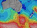 | 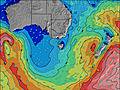 | 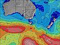 | 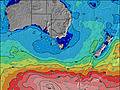 | |||||||||||||
Wave Height (m) Direction Period (s) | S 18 | S 18 | S 17 | S 16 | S 15 | S 14 | S 13 | S 13 | S 8 | S 8 | S 21 | S 19 | S 19 | S 18 | S 8 | SSW 14 | S 18 | S 19 | S 19 | S 18 |
Wave Graph | ||||||||||||||||||||
318 | 413 | 293 | 190 | 70 | 36 | 31 | 13 | 21 | 51 | 33 | 192 | 28 | 24 | 11 | 20 | 57 | 116 | 112 | 96 | |
Wind (km/h) | ||||||||||||||||||||
Wind State on-shore cross-onshore cross-shore cross-offshore off-shore glassy | glassy | cross | cross | cross-on | cross-on | cross-on | cross | cross-off | cross-off | cross | off | cross-off | cross-off | cross-off | off | cross-off | cross-off | cross | glassy | cross |
High Tide | 9:09PM0.78m | 11:21AM0.58m | 10:06PM0.72m | 11:54AM0.64m | 11:14PM0.66m | 12:29PM0.70m | 00:32AM0.60m | 1:09PM0.76m | 1:58AM0.56m | 1:52PM0.83m | 3:26AM0.53m | 2:40PM0.88m | ||||||||
Low Tide | 4:38AM0.16m | 4:04PM0.43m | 5:13AM0.19m | 5:28PM0.39m | 5:49AM0.24m | 6:48PM0.32m | 6:28AM0.29m | 8:02PM0.24m | 7:10AM0.34m | 9:11PM0.16m | 7:55AM0.39m | 10:16PM0.08m | ||||||||
— | — | 7:20 | — | — | 7:20 | — | — | 7:18 | — | — | 7:16 | — | — | 7:16 | — | — | 7:15 | — | — | |
5:09 | — | — | 5:10 | — | — | 5:12 | — | — | 5:13 | — | — | 5:14 | — | — | 5:15 | — | — | 5:15 | — | |
mm | — | — | — | — | — | — | — | — | — | 3 | — | — | — | — | — | — | — | — | — | — |
Temp °C | 14 | 10 | 14 | 16 | 9 | 12 | 10 | 9 | 11 | 10 | 8 | 11 | 11 | 9 | 11 | 11 | 9 | 13 | 14 | 10 |
Feels °C | 12 | 6 | 10 | 13 | 4 | 8 | 6 | 7 | 8 | 7 | 6 | 8 | 7 | 6 | 8 | 6 | 7 | 10 | 12 | 6 |
Swell 1 Height (m) Direction Period (s) | S 18 | S 18 | S 17 | S 16 | S 15 | S 14 | S 13 | S 13 | S 8 | S 8 | SSE 7 | SSE 7 | SSE 7 | S 6 | S 8 | SE 8 | S 18 | S 19 | S 19 | S 18 |
318 | 413 | 293 | 190 | 70 | 36 | 31 | 13 | 21 | 51 | 17 | 17 | 9 | 7 | 11 | 3 | 57 | 116 | 112 | 96 | |
Swell 2 Height (m) Direction Period (s) | SSE 12 | SE 12 | SE 12 | SE 10 | SE 14 | S 18 | S 18 | S 18 | S 12 | S 15 | S 21 | S 20 | S 19 | S 8 | SE 10 | S 19 | S 4 | SSE 7 | SE 7 | E 7 |
14 | 110 | 5 | 28 | 8 | 7 | 7 | 6 | 3 | 4 | 33 | 30 | 28 | 5 | 4 | 7 | 1 | 5 | 2 | 28 | |
Swell 3 Height (m) Direction Period (s) | — | — | — | E 18 | SE 14 | S 14 | ESE 14 | — | S 16 | S 20 | S 9 | S 19 | S 8 | S 18 | S 13 | SSW 14 | S 7 | SSW 15 | SW 14 | SE 11 |
— | — | — | 6 | 8 | 4 | 18 | — | 5 | 8 | 6 | 192 | 6 | 24 | 3 | 20 | 1 | 91 | 53 | 5 | |
Wind waves Height (m) Direction Period (s) | — | E 12 | NNW 3 | — | NNW 2 | — | — | — | W 3 | SSW 3 | WSW 2 | — | — | SW 3 | — | S 4 | — | — | — | — |
— | 11 | 3 | — | 1 | — | — | — | 1 | 1 | 1 | — | — | 1 | — | 9 | — | — | — | — | |
Nearest Offshore or Glassy | ||||||||||||||||||||
Distance (km) | 1 | 9 | 9 | 9 | 9 | 9 | 10 | 9 | 9 | 29 | 10 | 1 | 568 | 12 | 50 | 530 | 9 | 5 | 1 | 9 |
Best forecast wave conditions in East Coast of Tasmania | ||||||||||||||||||||
Best forecast wave conditions in Australia | ||||||||||||||||||||
Header Global | ||||||||||||||||||||
- Map Icons:
 Break
Break Live Wave Height (m)
 Live Wind Speed (km/h)
 Surf Rating (10 Max)
 Ocean Swells (m)
- Wind Speed (km/h)
Latest Updates


FREE! Surf-Forecast.com widget for your website
The surf report / weather widget below is available to embed on third party websites free of charge and provides a summary of our Lauderdale Point surf forecast. Simply grab the html code snippet that we provide and paste it into your own site. You can choose your preferred language and metric/imperial units for the surf forecast feed to suit users of your site. Click here to get the code.
Information about the Lauderdale Point Surf forecast
The above surf forecast table for Lauderdale Point provides essential information for determining whether the surfing conditions will be good over the next 16 days. A general guide to surfing at Lauderdale Point can be found by selecting the local surf guide option on the grey menu. Our Lauderdale Point surf forecast is unique since it includes wave energy (power) that defines the real feel of the surf rather than just the height or the period. If you surf the same spot (Lauderdale Point) regularly then make a mental note of the wave energy from the surf forecast table each time you go. Very soon you may start to choose your surf days based on the wave energy alone combined with our forecast of favourable offshore wind conditions. Our star ratings will help here and of course you will also find the usual wave height and period predictions on our surf forecasts as well as a full break down of the swell components under our advanced users option (to reveal that, click the little Einstein character under the tide times).
Further information to help with frequently asked questions about our surf forecast for Lauderdale Point may be found under the help tab on the top menu and also by moving your mouse over the question marks on the surf forecast table itself. Please always bear in mind that the forecast is for near-shore open water and local factors at each surf break influence the actual breaking wave height, such as the beach / reef profile, water depths offshore and shelter.
Are you planning a holiday in East Coast of Tasmania? If you are looking for accommodation near Lauderdale Point, camping, hotels and holiday cottages in East Coast of Tasmania, consider staying in Hobart which is 17 km (11 miles) away. Alternatively, find information about places to stay and car hire in Port Arthur which is 37 km (23 miles) away
 Nearest