

Surf Forecasts:

Clifton Beach surf forecast from 3 Aug 2026:
- Best quality surf: Monday 10 Aug, 7PM (local time) - 5ft (1.6m), 18s period, SSW swell with cross-offshore winds.
- Most powerful swell: Monday 10 Aug, 10PM (local time) - 5.5ft (1.7m), 18s period, SSW swell with 1,855 kJ wave energy.
- Next surfable swell (1★+): Tuesday 4 Aug, 7AM (local time) - 1.5ft (0.4m), 12s period with SSW swell.
Best Forecast Surf Conditions for Clifton Beach this week:
The surf forecast for Clifton Beach over the next 16 days: The first swell (rated 1 star or higher) is forecast to arrive on Tuesday (Aug 04) at 7AM. The primary swell is predicted to be 0.4m and 12s period with a secondary swell of 0.3m and 16s. Another secondary swell of 0.4m and 3s is also forecast. The wind is predicted to be cross-offshore as the swell arrives.
The most powerful waves expected at Clifton Beach in the next 16 days are 1.7m 18s and forecast to arrive on Monday (Aug 10) at 10PM. Winds are predicted to be cross-offshore at the time the swell arrives. The largest open ocean swell (not directed at the beach) is 1.1m 5s period and expected on Sunday (Aug 09) at 4AM.
| Wave Type | Time (AEST) & Date | Wave Height & Period |
|---|---|---|
| Next good surf (1 star+) | 7AM (Tue 4th Aug) | 1.5ft (0.4m) 12s |
| Best Surf | 7PM (Mon 10th Aug) | 5ft (1.6m) 18s |
| Most Powerful | 10PM (Mon 10th Aug) | 5.5ft (1.7m) 18s |
Table - best surf conditions forecast for Clifton Beach over the next 16 days.
The Lowdown
Alright, Rusty here. Let's take a look at what's cookin' at Clifton Beach over the next two weeks. It's a bit of a rollercoaster, so strap in.
The early part is sleepy. The first real sniff of a surf comes on the afternoon of Monday the 3rd of August. It's glassy out there, but the swell is a tiny 1ft from the SSW, with a long 13-second period. There's a bit of energy (100) but it's just not enough to get the heart pumpin'. The water temp is about 53°F, which is a touch colder than average for this time of year.
Tuesday the 4th, we get a little pulse from the SE in the afternoon with a short period, but the wind is all over the place. Wednesday morning the 5th is glassy again with a 0.7ft SSW groundswell from a super long 19-second period, pushing some moderate energy (150). It's a tease, but you'll be waiting for a set.
The real window opens up on the morning of Saturday the 8th of August. Clifton is showing a clean 2ft SSW swell, 16-second period, with a fresh offshore wind from the north at 12 mph. The energy is up to 289. This is the best on offer in the first week. The wind will make it clean, and the long period will give the waves some punch. The crowds will be possible here, as it's a fairly consistent break for a south swell.
Sunday the 9th, the wind stays offshore, but the swell drops back to 1ft and the energy fades.
Then we hit a rough patch. From late Sunday through the middle of the next week, the wind gets nasty. Monday the 10th, the swell bumps up to 3ft and then 4ft, but the wind is a strong cross-shore, making a mess. The energy is high (534 and 917), but with that wind, you're better off with a kite than a paddle. It's a choppy, blown-out mess.
The next runner is the morning of Tuesday the 11th of August. We've got a clean 4ft SSW swell, 17-second period, with a moderate offshore wind from the north at 16 mph. The energy is pumping at 804. This is a solid groundswell, and the offshore wind is a huge plus. The report says "marginal" due to tide, but this is the best-looking swell of the period. It's a solid wave, good for the average surfer, but the long period means it'll be a bit more lined up. I'd call this a standout.
Wednesday the 12th morning keeps the offshore flow with a 4ft SSW swell, 17-second period, and energy at 869. The afternoon gets bigger, hitting 5ft with a 19-second period and energy up to 1642. The wind is a strong offshore, which is great for the face, but the report says it's "hard to paddle into." That's a warning for the experts only. The sets will be long and powerful, and the crowd will be on it.
Thursday the 13th morning brings a clean 3ft SSW swell with a 17-second period and a light cross-offshore breeze. Energy is 522. The afternoon gets blown out by a near gale from the SSW, so get in early.
After that, the wind goes onshore or cross-shore for a few days. Friday the 14th and Saturday the 15th are messy, with bumpy conditions.
The final week, we've got a pulse on the 17th of August Monday morning. A 5ft S swell, 17-second period, and energy at 1832 – that's a lot of power. The wind is a gentle cross-shore, so it's clean enough. The long period might make it a bit straight at the beach, but Clifton should handle it. This is a promising one for the second week, but it's a long way out, so don't plan your life around it yet.
Best Bets: The morning of Saturday 8th August is the pick for clean, small waves. For a bigger, more powerful session, the morning of Tuesday 11th August and Wednesday 12th August are the ones to mark. The 12th afternoon is for the brave.
Rusty.
Short Range ForecastModerate rain (total 10mm), heaviest on Tue afternoon. Very mild (max 12°C on Mon afternoon, min 8°C on Mon night). Wind will be generally light. | Days 5-7 Weather SummaryMostly dry. Very mild (max 14°C on Sat afternoon, min 5°C on Fri night). Winds increasing (calm on Fri morning, fresh winds from the N by Sun morning). | |||||||||||||||||||
Mon 3 | Tuesday 4 | Wednesday 5 | Thursday 6 | Friday 7 | Saturday 8 | Sunday 9 | ||||||||||||||
PM | Night | AM | PM | Night | AM | PM | Night | AM | PM | Night | AM | PM | Night | AM | PM | Night | AM | PM | Night | |
Swell Height Map |  |  |  | 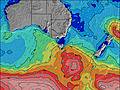 | 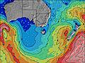 | 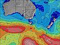 | 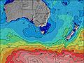 | |||||||||||||
Wave Height (m) Direction Period (s) | SSW 13 | SSW 13 | SSW 12 | SE 8 | S 20 | SSW 19 | SSW 19 | SW 5 | SSW 16 | SSW 18 | SSW 18 | SSW 16 | SSW 19 | SSW 18 | SSW 16 | SSW 16 | SW 14 | SW 17 | SSW 17 | SSW 19 |
Wave Graph | ||||||||||||||||||||
69 | 59 | 49 | 50 | 71 | 125 | 68 | 23 | 25 | 65 | 547 | 102 | 122 | 103 | 283 | 201 | 61 | 75 | 119 | 387 | |
Wind (km/h) | ||||||||||||||||||||
Wind State on-shore cross-onshore cross-shore cross-offshore off-shore glassy | glassy | cross | cross | cross-off | cross-off | glassy | cross-on | cross-off | cross-off | glassy | cross-off | cross | cross-on | off | off | cross-off | off | off | off | cross-off |
High Tide | 10:07PM0.54m | 11:21AM0.57m | 11:24PM0.49m | 12:01PM0.63m | 00:48AM0.46m | 12:46PM0.68m | 2:14AM0.44m | 1:34PM0.72m | 3:37AM0.42m | 2:25PM0.76m | 4:53AM0.42m | 3:18PM0.78m | ||||||||
Low Tide | 4:19PM0.31m | 4:42AM0.19m | 5:39PM0.26m | 5:21AM0.23m | 6:53PM0.20m | 6:04AM0.27m | 8:02PM0.13m | 6:50AM0.30m | 9:07PM0.07m | 7:37AM0.33m | 10:10PM0.02m | 8:25AM0.35m | 11:10PM-0.01m | |||||||
— | — | 7:18 | — | — | 7:18 | — | — | 7:16 | — | — | 7:15 | — | — | 7:13 | — | — | 7:13 | — | — | |
5:12 | — | — | 5:13 | — | — | 5:14 | — | — | 5:15 | — | — | 5:15 | — | — | 5:16 | — | — | 5:17 | — | |
mm | — | — | — | 10 | — | — | — | — | — | — | — | — | — | — | — | — | — | — | — | 1 |
Temp °C | 12 | 10 | 9 | 9 | 9 | 10 | 12 | 11 | 11 | 12 | 11 | 10 | 11 | 9 | 12 | 14 | 10 | 12 | 12 | 10 |
Feels °C | 10 | 8 | 6 | 6 | 7 | 6 | 8 | 8 | 9 | 10 | 9 | 8 | 7 | 5 | 8 | 10 | 2 | 5 | 6 | 3 |
Swell 1 Height (m) Direction Period (s) | SSW 13 | SSW 13 | SSW 12 | SE 8 | SE 8 | ESE 8 | ESE 10 | ESE 9 | E 9 | E 8 | E 8 | SSE 6 | S 6 | SSW 18 | SSW 16 | SSW 16 | SW 14 | SW 17 | SSW 17 | SSW 19 |
69 | 57 | 49 | 50 | 70 | 39 | 74 | 133 | 57 | 52 | 35 | 15 | 27 | 103 | 283 | 201 | 54 | 75 | 119 | 387 | |
Swell 2 Height (m) Direction Period (s) | SSW 18 | SSW 17 | ESE 5 | SSW 15 | S 9 | S 9 | SSW 19 | SW 5 | SSE 8 | SSW 18 | SE 8 | SSW 16 | SSW 19 | S 6 | SE 7 | SE 7 | SSW 18 | E 8 | ENE 5 | E 8 |
31 | 59 | 2 | 21 | 15 | 25 | 68 | 4 | 6 | 65 | 2 | 102 | 122 | 11 | 13 | 8 | 61 | 1 | 2 | 6 | |
Swell 3 Height (m) Direction Period (s) | NNE 3 | E 5 | SSW 16 | SSW 11 | S 20 | SSW 19 | SSW 14 | S 8 | SSW 16 | SSE 8 | SE 11 | E 8 | SW 14 | SE 8 | SSW 8 | E 10 | ESE 7 | E 10 | ENE 8 | SW 6 |
1 | 2 | 25 | 11 | 71 | 125 | 37 | 12 | 25 | 6 | 4 | 10 | 53 | 15 | 6 | 2 | 5 | 2 | 7 | 1 | |
Wind waves Height (m) Direction Period (s) | NNW 4 | — | SW 3 | SW 4 | — | — | S 8 | SW 5 | SW 5 | SSW 5 | SSW 18 | SSW 6 | SSW 6 | — | — | NNE 3 | NNE 5 | NE 5 | NNW 3 | NNW 3 |
1 | — | 2 | 3 | — | — | 36 | 23 | 20 | 10 | 547 | 26 | 26 | — | — | 1 | 27 | 51 | 3 | 5 | |
Nearest Offshore or Glassy | ||||||||||||||||||||
Distance (km) | 0 | 4 | 4 | 0 | 0 | 0 | 8 | 4 | 4 | 0 | 0 | 6 | 8 | 0 | 0 | 0 | 0 | 15 | 11 | 36 |
Best forecast wave conditions in East Coast of Tasmania | ||||||||||||||||||||
Best forecast wave conditions in Australia | ||||||||||||||||||||
Header Global | ||||||||||||||||||||
- Map Icons:
 Break
Break Live Wave Height (m)
 Live Wind Speed (km/h)
 Surf Rating (10 Max)
 Ocean Swells (m)
- Wind Speed (km/h)
Latest Updates


FREE! Surf-Forecast.com widget for your website
The surf report / weather widget below is available to embed on third party websites free of charge and provides a summary of our Clifton Beach surf forecast. Simply grab the html code snippet that we provide and paste it into your own site. You can choose your preferred language and metric/imperial units for the surf forecast feed to suit users of your site. Click here to get the code.
Information about the Clifton Beach Surf forecast
The above surf forecast table for Clifton Beach provides essential information for determining whether the surfing conditions will be good over the next 16 days. A general guide to surfing at Clifton Beach can be found by selecting the local surf guide option on the grey menu. Our Clifton Beach surf forecast is unique since it includes wave energy (power) that defines the real feel of the surf rather than just the height or the period. If you surf the same spot (Clifton Beach) regularly then make a mental note of the wave energy from the surf forecast table each time you go. Very soon you may start to choose your surf days based on the wave energy alone combined with our forecast of favourable offshore wind conditions. Our star ratings will help here and of course you will also find the usual wave height and period predictions on our surf forecasts as well as a full break down of the swell components under our advanced users option (to reveal that, click the little Einstein character under the tide times).
Further information to help with frequently asked questions about our surf forecast for Clifton Beach may be found under the help tab on the top menu and also by moving your mouse over the question marks on the surf forecast table itself. Please always bear in mind that the forecast is for near-shore open water and local factors at each surf break influence the actual breaking wave height, such as the beach / reef profile, water depths offshore and shelter.
Are you planning a holiday in East Coast of Tasmania? If you are looking for accommodation near Clifton Beach, camping, hotels and holiday cottages in East Coast of Tasmania, consider staying in Hobart which is 21 km (13 miles) away. Alternatively, find information about places to stay and car hire in Port Arthur which is 30 km (19 miles) away
 Nearest