

Surf Forecasts:

Generosa surf forecast from 17 Jul 2026:
- Most powerful swell: Thursday 23 Jul, 10PM (local time) - 5.5ft (1.7m), 8s period, N swell with 336 kJ wave energy.
Best Forecast Surf Conditions for Generosa this week:
The most powerful waves expected at Generosa in the next 16 days are 1.7m 8s and forecast to arrive on Thursday (Jul 23) at 10PM. Winds are predicted to be onshore at the time the swell arrives. The largest open ocean swell (not directed at the beach) is 0.1m 16s period and expected on Sunday (Jul 19) at 10AM.
| Wave Type | Time (WEST) & Date | Wave Height & Period |
|---|---|---|
| Next good surf (1 star+) | - | - |
| Best Surf | - | - |
| Most Powerful | 10PM (Thu 23rd Jul) | 5.5ft (1.7m) 8s |
Table - best surf conditions forecast for Generosa over the next 16 days.
The Lowdown
Alright folks, Rusty here. Let’s have a look at what’s on the cards for the next 16 days.
Straight up, I’ve got to be honest with you – this is a tough one. The forecast is showing a solid run of surf, but the wind is just not playing ball. For the entire 16-day window, we’re looking at onshore winds, mostly from the north and north-northeast, blowing at 15 to 22 mph. That’s a real problem. The swell is there, but it’s always going to be chopped up and messy. Even with the swell building, the wave comment is consistently "poor surf conditions," and that’s exactly what it’s going to be.
The only named break in the data is Generosa, a consistent intermediate reef break. It’s exposed to the swell, and the optimum direction is from the NNW. The swell we’re getting is mostly from the N and NNE, which is a bit off its best. The first week is a write-off. From Friday, July 17th right through to the end of the month, we’ve got swell heights starting at 3 ft and building to 7 ft, but it’s all onshore, onshore, onshore. The wind is not letting up. The combined wave energy goes from weak (93) to moderate (351) in the first week, but it’s all for nothing with that wind. A couple of times in the second week, we see the period stretching to 10 seconds, which is a better quality groundswell, but the wind is still on it, so it’s still going to be a messy, lumpy affair.
The real standout, if you can call it that, comes in the last week. On Monday, July 27th, we see a jump in energy. The combined energy hits 1146, which is strong. The swell is 7 ft from the NE with a period of 9 seconds. That’s a decent amount of water moving. But again, the wind is onshore from the NNE at 19 mph. This is a big, powerful swell, but it’s going to be blown out. For a reef break like Generosa, that 7 ft+ swell with a 9-second period is going to be a challenge, and with the wind raking across it, it’s really only for the experts who don’t mind a fight. The crowds are listed as "sometimes," so you might not have to share the mess, which is a small mercy.
The best of a bad bunch is likely Wednesday, July 29th. The swell is 7 ft from the N with a 10-second period, and the wind drops slightly to a moderate 12 mph from the NNW. That’s the closest we get to a clean offshore wind from the NNW, which is the optimum direction. The combined energy is 936, a strong, powerful swell. It’s still not perfect, but it’s the least bad option. That afternoon, it’s likely the most rideable it will be all fortnight.
For the rest of it, if you’re a beginner, stay well away. The swell is over 5 ft for most of the second week and hits over 8 ft on the 27th and 28th. That’s expert territory. Honestly, this setup looks more interesting for kite surfing than paddle surfing. The wind is strong and consistent, and the swell is there. For a surfer, it’s a frustrating run.
Rusty.
Short Range ForecastMostly dry. Warm (max 23°C on Fri afternoon, min 20°C on Thu night). Mainly fresh winds. | Days 4-6 Weather SummaryMostly dry. Warm (max 22°C on Mon morning, min 20°C on Sun night). Mainly fresh winds. | ||||||||||||||||||||
Friday 17 | Saturday 18 | Sunday 19 | Monday 20 | Tuesday 21 | Wednesday 22 | Thursday 23 | |||||||||||||||
AM | PM | Night | AM | PM | Night | AM | PM | Night | AM | PM | Night | AM | PM | Night | AM | PM | Night | AM | PM | Night | |
Swell Height Map |  |  |  | 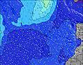 | 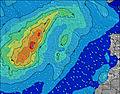 | 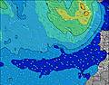 | 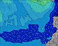 | ||||||||||||||
Wave Height (m) Direction Period (s) | N 5 | NNE 6 | NNE 6 | NNE 6 | N 6 | NNE 6 | NNE 6 | NNE 7 | NNE 6 | N 7 | N 7 | N 7 | N 7 | N 7 | N 7 | N 7 | N 7 | N 7 | N 7 | N 8 | N 8 |
Wave Graph | |||||||||||||||||||||
47 | 83 | 80 | 101 | 108 | 108 | 134 | 152 | 170 | 226 | 245 | 196 | 205 | 179 | 198 | 204 | 276 | 276 | 276 | 290 | 336 | |
Wind (km/h) | |||||||||||||||||||||
Wind State on-shore cross-onshore cross-shore cross-offshore off-shore glassy | on | on | cross-on | on | on | cross-on | on | on | on | on | on | on | on | on | on | on | on | cross-on | on | on | on |
High Tide | 4:20AM2.27m | 4:35PM2.55m | 5:04AM2.18m | 5:19PM2.41m | 5:48AM2.06m | 6:04PM2.23m | 6:34AM1.94m | 6:52PM2.02m | 7:25AM1.82m | 7:46PM1.82m | 8:24AM1.72m | 8:52PM1.67m | 9:35AM1.68m | 10:11PM1.61m | |||||||
Low Tide | 10:15AM0.17m | 10:54PM0.08m | 10:58AM0.27m | 11:37PM0.23m | 11:42AM0.40m | 00:21AM0.39m | 12:29PM0.55m | 1:07AM0.56m | 1:24PM0.70m | 2:00AM0.71m | 2:31PM0.80m | 3:05AM0.80m | 3:53PM0.84m | ||||||||
7:07 | — | — | 7:07 | — | — | 7:09 | — | — | 7:09 | — | — | 7:09 | — | — | 7:09 | — | — | 7:11 | — | — | |
— | 8:54 | — | — | 8:53 | — | — | 8:53 | — | — | 8:52 | — | — | 8:52 | — | — | 8:52 | — | — | 8:52 | — | |
mm | — | — | — | — | — | — | — | — | — | — | — | — | — | — | — | — | — | — | — | — | — |
Temp °C | 22 | 23 | 21 | 22 | 22 | 21 | 22 | 22 | 21 | 22 | 22 | 21 | 22 | 22 | 21 | 22 | 22 | 21 | 22 | 22 | 21 |
Feels °C | 20 | 22 | 20 | 21 | 20 | 20 | 20 | 19 | 19 | 19 | 19 | 19 | 20 | 19 | 19 | 19 | 19 | 18 | 20 | 19 | 20 |
Swell 1 Height (m) Direction Period (s) | ENE 7 | WNW 8 | WNW 8 | WNW 7 | WNW 8 | WNW 8 | WNW 9 | WNW 9 | NW 8 | NW 8 | WNW 8 | WNW 7 | WNW 12 | NW 11 | NW 11 | NW 10 | NW 10 | NW 9 | N 10 | N 9 | NW 9 |
19 | 13 | 13 | 5 | 6 | 6 | 16 | 16 | 17 | 17 | 12 | 5 | 14 | 19 | 29 | 25 | 24 | 22 | 30 | 41 | 20 | |
Swell 2 Height (m) Direction Period (s) | WNW 8 | — | — | NW 9 | W 11 | WNW 10 | S 16 | S 16 | — | S 14 | W 13 | NNW 9 | WNW 7 | NW 7 | WNW 8 | S 13 | NW 8 | N 11 | NW 9 | NW 9 | — |
26 | — | — | 3 | 2 | 10 | 5 | 5 | — | 4 | 3 | 8 | 5 | 2 | 7 | 3 | 2 | 2 | 21 | 20 | — | |
Swell 3 Height (m) Direction Period (s) | N 8 | — | — | W 9 | S 18 | — | — | — | — | — | S 14 | NW 12 | NNW 9 | W 9 | S 13 | — | S 13 | S 11 | — | — | — |
1 | — | — | 2 | 6 | — | — | — | — | — | 4 | 6 | 8 | 2 | 3 | — | 3 | 2 | — | — | — | |
Wind waves Height (m) Direction Period (s) | N 5 | NNE 6 | NNE 6 | NNE 6 | N 6 | NNE 6 | NNE 6 | NNE 7 | NNE 6 | N 7 | N 7 | N 7 | N 7 | N 7 | N 7 | N 7 | N 7 | N 7 | N 7 | N 8 | N 8 |
47 | 83 | 80 | 101 | 108 | 108 | 134 | 152 | 170 | 226 | 245 | 196 | 205 | 179 | 198 | 204 | 276 | 276 | 276 | 290 | 336 | |
Nearest Offshore or Glassy | |||||||||||||||||||||
Distance (km) | 440 | 207 | 294 | 207 | 181 | 207 | 207 | 288 | 288 | 207 | 207 | 287 | 288 | 288 | 288 | 288 | 288 | 288 | 288 | 288 | 288 |
Best forecast wave conditions in Fuerteventura | |||||||||||||||||||||
Best forecast wave conditions in Spain (Africa) | |||||||||||||||||||||
Header Global | |||||||||||||||||||||
- Map Icons:
 Break
Break Live Wave Height (m)
 Live Wind Speed (km/h)
 Surf Rating (10 Max)
 Ocean Swells (m)
- Wind Speed (km/h)


FREE! Surf-Forecast.com widget for your website
The surf report / weather widget below is available to embed on third party websites free of charge and provides a summary of our Generosa surf forecast. Simply grab the html code snippet that we provide and paste it into your own site. You can choose your preferred language and metric/imperial units for the surf forecast feed to suit users of your site. Click here to get the code.
Information about the Generosa Surf forecast
The above surf forecast table for Generosa provides essential information for determining whether the surfing conditions will be good over the next 16 days. A general guide to surfing at Generosa can be found by selecting the local surf guide option on the grey menu. Our Generosa surf forecast is unique since it includes wave energy (power) that defines the real feel of the surf rather than just the height or the period. If you surf the same spot (Generosa) regularly then make a mental note of the wave energy from the surf forecast table each time you go. Very soon you may start to choose your surf days based on the wave energy alone combined with our forecast of favourable offshore wind conditions. Our star ratings will help here and of course you will also find the usual wave height and period predictions on our surf forecasts as well as a full break down of the swell components under our advanced users option (to reveal that, click the little Einstein character under the tide times).
Further information to help with frequently asked questions about our surf forecast for Generosa may be found under the help tab on the top menu and also by moving your mouse over the question marks on the surf forecast table itself. Please always bear in mind that the forecast is for near-shore open water and local factors at each surf break influence the actual breaking wave height, such as the beach / reef profile, water depths offshore and shelter.
Are you planning a holiday in Fuerteventura? If you are looking for accommodation near Generosa, camping, hotels and holiday cottages in Fuerteventura, consider staying in La Oliva which is 16 km (10 miles) away. Other places in and around Fuerteventura where you can find information about places to rent, and car hire include Puerto del Rosario which is 28 km (17 miles) away, Puerto del Carmen, Tias and Lanzarote.
 Nearest