

Surf Forecasts:

El Roque surf forecast from 3 Aug 2026:
- Most powerful swell: Saturday 8 Aug, 4PM (local time) - 7ft (2.1m), 8s period, NNE swell with 636 kJ wave energy.
Best Forecast Surf Conditions for El Roque this week:
The most powerful waves expected at El Roque in the next 16 days are 2.1m 8s and forecast to arrive on Saturday (Aug 08) at 4PM. Winds are predicted to be onshore at the time the swell arrives. The largest open ocean swell (not directed at the beach) is 0.1m 12s period and expected on Monday (Aug 03) at 10PM.
| Wave Type | Time (WEST) & Date | Wave Height & Period |
|---|---|---|
| Next good surf (1 star+) | - | - |
| Best Surf | - | - |
| Most Powerful | 4PM (Sat 8th Aug) | 7ft (2.1m) 8s |
Table - best surf conditions forecast for El Roque over the next 16 days.
The Lowdown
Alright folks, Rusty here. Let’s have a look at what’s shaping up. We’re staring down a long, frustrating stretch. The short version: there’s nothing good to surf for the next 16 days at El Roque. Every single day in the forecast is marked as poor surf conditions. That’s a hard pill to swallow, but I’m not going to sugarcoat it.
The first recommendation comes on Monday, August 3rd, but don’t get your hopes up. The water temperature is sitting at 73°, which is about average for this time of year, nothing weird there. The swell is from the NNE at 5 ft, with a short-period of 7 seconds and weak combined energy (210). The wind is onshore from the north at 9 mph, making it messy. It’s just not a goer. This same story repeats day after day. The swell bumps up a bit, like Wednesday August 5th with 6 ft from the NE and a bit more energy (358), but it’s still cross-onshore and choppy. Through the first week, the wind stays mostly onshore or cross-onshore, with speeds between 9 to 16 mph. The swell period stays short, between 6 and 9 seconds, so it’s all windswell, no real grunt.
There’s a gap of several days, but it’s not a gap of options – it’s a gap of quality. By the second week, around August 12th, the swell height gets up to 7 ft, with energy climbing into the 400s and 500s. Still, the wind is onshore or cross-on, and the period is still short. On August 15th, we see 7 ft from the NNE, and then August 16th hits 8 ft with energy at 719, but it’s all for nothing – the conditions are still rated poor. The swell is too big for beginners at that point, and the short period means it’s just a crumbly, choppy mess. By August 18th, the swell hits 8 ft, the biggest of the forecast, with energy at 819, and the period finally stretches to 9 seconds. But the wind is a moderate cross-onshore at 12-16 mph, making it choppy and ugly. Honestly, with that much wind and that short of a period, this setup looks more interesting for kite surfing than paddle surfing.
The surf break is a reef, and it’s fairly consistent, but with the wind coming from the wrong direction and the swell clocking in from the NNE, not the optimum NNW, it’s just not coming together. Roque is inconsistent enough as it is, so a blank run like this is more normal for the area. It’s a bummer, but it happens. The best advice I can give is to keep an eye on the forecast – it tends not to stay poor for long. But for now, save your energy.
Rusty.
Short Range ForecastMostly dry. Warm (max 27°C on Mon afternoon, min 21°C on Wed night). Wind will be generally light. | Days 4-6 Weather SummaryMostly dry. Warm (max 25°C on Sat afternoon, min 21°C on Thu night). Wind will be generally light. | ||||||||||||||||||||
Monday 3 | Tuesday 4 | Wednesday 5 | Thursday 6 | Friday 7 | Saturday 8 | Sunday 9 | |||||||||||||||
AM | PM | Night | AM | PM | Night | AM | PM | Night | AM | PM | Night | AM | PM | Night | AM | PM | Night | AM | PM | Night | |
Swell Height Map |  |  |  | 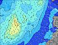 | 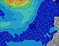 | 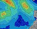 | 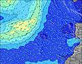 | ||||||||||||||
Wave Height (m) Direction Period (s) | NNE 7 | NNE 7 | NNE 6 | NE 6 | NNE 7 | NNE 7 | NE 7 | NE 7 | NE 7 | NE 7 | NNE 7 | NNE 8 | NNE 7 | NNE 8 | NNE 8 | NNE 8 | NNE 8 | NNE 8 | NNE 8 | NNE 7 | NNE 7 |
Wave Graph | |||||||||||||||||||||
180 | 170 | 170 | 172 | 192 | 237 | 323 | 313 | 287 | 303 | 362 | 353 | 379 | 434 | 511 | 614 | 636 | 547 | 375 | 225 | 225 | |
Wind (km/h) | |||||||||||||||||||||
Wind State on-shore cross-onshore cross-shore cross-offshore off-shore glassy | on | cross-on | on | cross-on | cross-on | on | cross-on | cross-on | on | on | on | on | on | on | on | on | on | on | on | on | on |
High Tide | 5:07PM2.03m | 5:33AM1.84m | 5:48PM1.92m | 6:19AM1.75m | 6:39PM1.78m | 7:18AM1.67m | 7:47PM1.65m | 8:35AM1.62m | 9:18PM1.59m | 10:05AM1.66m | 10:49PM1.65m | 11:22AM1.80m | 00:01AM1.78m | ||||||||
Low Tide | 10:50AM0.32m | 11:20PM0.29m | 11:30AM0.41m | 00:02AM0.38m | 12:19PM0.50m | 00:55AM0.49m | 1:24PM0.60m | 2:05AM0.59m | 2:52PM0.64m | 3:35AM0.62m | 4:29PM0.57m | 5:01AM0.55m | 5:46PM0.41m | ||||||||
7:24 | — | — | 7:24 | — | — | 7:26 | — | — | 7:26 | — | — | 7:26 | — | — | 7:28 | — | — | 7:28 | — | — | |
— | 8:51 | — | — | 8:50 | — | — | 8:49 | — | — | 8:49 | — | — | 8:47 | — | — | 8:46 | — | — | 8:45 | — | |
mm | — | — | — | — | — | — | — | — | — | — | — | — | — | — | — | — | — | — | — | — | — |
Temp °C | 26 | 27 | 24 | 26 | 26 | 24 | 24 | 25 | 22 | 23 | 24 | 22 | 24 | 24 | 22 | 24 | 25 | 23 | 24 | 24 | 22 |
Feels °C | 26 | 27 | 24 | 27 | 27 | 26 | 24 | 25 | 23 | 23 | 25 | 22 | 24 | 23 | 22 | 23 | 25 | 23 | 24 | 24 | 22 |
Swell 1 Height (m) Direction Period (s) | NW 9 | N 9 | NW 10 | NW 9 | NW 8 | NW 8 | NW 8 | NW 8 | NW 10 | N 10 | WNW 9 | WNW 9 | WNW 9 | WNW 9 | WNW 9 | WNW 9 | WNW 8 | WNW 8 | NW 8 | N 10 | NW 7 |
20 | 26 | 14 | 20 | 11 | 10 | 10 | 10 | 16 | 52 | 9 | 8 | 8 | 8 | 7 | 7 | 7 | 6 | 3 | 68 | 2 | |
Swell 2 Height (m) Direction Period (s) | NW 11 | NW 9 | S 12 | N 9 | NW 11 | NW 10 | NW 11 | N 11 | NNW 11 | WNW 10 | S 12 | S 11 | S 11 | S 11 | S 11 | S 10 | S 12 | S 12 | S 12 | WNW 8 | N 11 |
5 | 13 | 3 | 13 | 5 | 4 | 4 | 2 | 24 | 9 | 3 | 2 | 2 | 2 | 2 | 2 | 3 | 3 | 3 | 6 | 3 | |
Swell 3 Height (m) Direction Period (s) | NW 11 | — | S 10 | SW 12 | — | S 12 | N 11 | N 12 | N 11 | — | NW 9 | S 15 | — | S 13 | S 13 | — | — | — | — | NW 8 | S 11 |
5 | — | 2 | 6 | — | 3 | 2 | 3 | 2 | — | 3 | 4 | — | 3 | 3 | — | — | — | — | 2 | 2 | |
Wind waves Height (m) Direction Period (s) | NNE 7 | NNE 7 | NNE 6 | NE 6 | NNE 7 | NNE 7 | NE 7 | NE 7 | NE 7 | NE 7 | NNE 7 | NNE 8 | NNE 7 | NNE 8 | NNE 8 | NNE 8 | NNE 8 | NNE 8 | NNE 8 | NNE 7 | NNE 7 |
180 | 170 | 170 | 172 | 192 | 237 | 323 | 313 | 287 | 303 | 362 | 353 | 379 | 434 | 511 | 614 | 636 | 547 | 375 | 225 | 225 | |
Nearest Offshore or Glassy | |||||||||||||||||||||
Distance (km) | 70 | 107 | 70 | 72 | 70 | 70 | 70 | 70 | 70 | 70 | 70 | 70 | 70 | 70 | 525 | 525 | 124 | 538 | 70 | 70 | 70 |
Best forecast wave conditions in Gran Canaria | |||||||||||||||||||||
Best forecast wave conditions in Spain (Africa) | |||||||||||||||||||||
Header Global | |||||||||||||||||||||
- Map Icons:
 Break
Break Live Wave Height (m)
 Live Wind Speed (km/h)
 Surf Rating (10 Max)
 Ocean Swells (m)
- Wind Speed (km/h)
Latest Updates


FREE! Surf-Forecast.com widget for your website
The surf report / weather widget below is available to embed on third party websites free of charge and provides a summary of our El Roque surf forecast. Simply grab the html code snippet that we provide and paste it into your own site. You can choose your preferred language and metric/imperial units for the surf forecast feed to suit users of your site. Click here to get the code.
Information about the El Roque Surf forecast
The above surf forecast table for El Roque provides essential information for determining whether the surfing conditions will be good over the next 16 days. A general guide to surfing at El Roque can be found by selecting the local surf guide option on the grey menu. Our El Roque surf forecast is unique since it includes wave energy (power) that defines the real feel of the surf rather than just the height or the period. If you surf the same spot (El Roque) regularly then make a mental note of the wave energy from the surf forecast table each time you go. Very soon you may start to choose your surf days based on the wave energy alone combined with our forecast of favourable offshore wind conditions. Our star ratings will help here and of course you will also find the usual wave height and period predictions on our surf forecasts as well as a full break down of the swell components under our advanced users option (to reveal that, click the little Einstein character under the tide times).
Further information to help with frequently asked questions about our surf forecast for El Roque may be found under the help tab on the top menu and also by moving your mouse over the question marks on the surf forecast table itself. Please always bear in mind that the forecast is for near-shore open water and local factors at each surf break influence the actual breaking wave height, such as the beach / reef profile, water depths offshore and shelter.
Are you planning a holiday in Gran Canaria? If you are looking for accommodation near El Roque, camping, hotels and holiday cottages in Gran Canaria, consider staying in Arucas which is 5 km (3 miles) away. Other places in and around Gran Canaria where you can find information about places to rent, and car hire include Galdar which is 8 km (5 miles) away, Santa Brigida, Las Palmas and Telde.
 Nearest