

Surf Forecasts:

El Fronton surf forecast from 27 Jul 2026:
- Most powerful swell: Monday 27 Jul, 10AM (local time) - 5ft (1.6m), 8s period, NNE swell with 303 kJ wave energy.
Best Forecast Surf Conditions for El Fronton this week:
The most powerful waves expected at El Fronton in the next 16 days are 1.6m 8s and forecast to arrive on Monday (Jul 27) at 10AM. Winds are predicted to be onshore at the time the swell arrives. The largest open ocean swell (not directed at the beach) is 0.1m 13s period and expected on Monday (Jul 27) at 10AM.
| Wave Type | Time (WEST) & Date | Wave Height & Period |
|---|---|---|
| Next good surf (1 star+) | - | - |
| Best Surf | - | - |
| Most Powerful | 10AM (Mon 27th Jul) | 5ft (1.6m) 8s |
Table - best surf conditions forecast for El Fronton over the next 16 days.
The Lowdown
Alright folks, Rusty here. Let’s get into it.
We’ve got a bit of a flat spell on our hands for the entire 16-day outlook. Looking at the only break on the radar, El Fronton, it’s a real mixed bag of poor conditions. The overall pattern is dominated by onshore and cross-onshore winds from the north-northeast, which is just going to keep things messy. There’s a long gap of poor surf here, so don’t get your hopes up for a quick fix.
Starting Monday, July 27, through the morning the swell is around 5 ft from the NNE but with a short 8-second period, and the wind is onshore. The water is about average for the time of year. The combined swell energy is moderate (303). It’s just not happening. This continues through the week with the same story: 4 ft to 5 ft, short period, and that wind from the NNE holding it down. Even by Saturday, August 1, the swell drops to 4 ft from the north with a light wind, but the energy is weak (260) and the onshore flow is still a factor.
The only real standout in the whole period, and it’s a long way off, is around Sunday, August 9. The swell picks up to 7 ft from the NNE on the morning, with a moderate combined energy of 644. By the afternoon it’s 8 ft, with energy jumping to 809. That’s a solid push. But here’s the catch – the wind is still cross-onshore from the NE, and the swell period is short at 8 seconds. This is a reef break, but with that short-period, onshore wind, it’s going to be a lumpy, choppy mess. For the experts only, maybe, but it looks more like a kite-surfing setup than a clean paddle session. The crowds are ‘often’ here, so expect company if you’re determined.
Honestly, for the whole 16 days, there’s not a single entry that scores well. The surf quality is repeatedly described as poor. It’s a blank run for the area, and this one’s a tough one to call.
Rusty.
Short Range ForecastMostly dry. Warm (max 23°C on Mon morning, min 20°C on Tue night). Wind will be generally light. | Days 4-6 Weather SummaryMostly dry. Warm (max 25°C on Fri afternoon, min 21°C on Wed night). Wind will be generally light. | ||||||||||||||||||||
Monday 27 | Tuesday 28 | Wednesday 29 | Thursday 30 | Friday 31 | Saturday 1 | Sunday 2 | |||||||||||||||
AM | PM | Night | AM | PM | Night | AM | PM | Night | AM | PM | Night | AM | PM | Night | AM | PM | Night | AM | PM | Night | |
Swell Height Map |  |  |  | 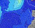 | 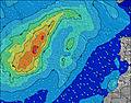 | 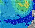 | 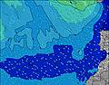 | ||||||||||||||
Wave Height (m) Direction Period (s) | NNE 8 | NNE 8 | NNE 8 | NNE 8 | NNE 8 | NNE 7 | NNE 7 | NNE 6 | NNE 5 | NNE 6 | NNE 6 | NNE 6 | NNE 6 | NNE 6 | NNE 7 | N 7 | NNE 7 | NNE 7 | NNE 7 | NNE 7 | NNE 6 |
Wave Graph | |||||||||||||||||||||
303 | 263 | 232 | 186 | 176 | 177 | 149 | 93 | 93 | 145 | 136 | 127 | 140 | 149 | 222 | 113 | 155 | 96 | 91 | 73 | 90 | |
Wind (km/h) | |||||||||||||||||||||
Wind State on-shore cross-onshore cross-shore cross-offshore off-shore glassy | on | on | cross-on | on | cross-on | cross-on | cross-on | cross-on | on | cross-on | cross-on | cross-on | cross-on | cross-on | cross-on | on | on | on | on | on | cross-on |
High Tide | 1:12PM1.82m | 1:34AM1.72m | 1:48PM1.94m | 2:09AM1.80m | 2:22PM2.03m | 2:41AM1.86m | 2:54PM2.10m | 3:13AM1.90m | 3:25PM2.13m | 3:45AM1.91m | 3:57PM2.13m | 4:17AM1.91m | 4:30PM2.08m | ||||||||
Low Tide | 6:56AM0.49m | 7:28PM0.39m | 7:32AM0.39m | 8:03PM0.30m | 8:05AM0.31m | 8:36PM0.23m | 8:37AM0.25m | 9:07PM0.19m | 9:08AM0.22m | 9:39PM0.17m | 9:40AM0.22m | 10:10PM0.17m | 10:13AM0.25m | 10:43PM0.21m | |||||||
7:20 | — | — | 7:22 | — | — | 7:22 | — | — | 7:22 | — | — | 7:24 | — | — | 7:24 | — | — | 7:24 | — | — | |
— | 8:55 | — | — | 8:54 | — | — | 8:54 | — | — | 8:53 | — | — | 8:52 | — | — | 8:52 | — | — | 8:52 | — | |
mm | — | — | — | — | — | — | — | — | — | — | — | — | — | — | — | — | — | — | — | — | — |
Temp °C | 23 | 23 | 21 | 22 | 22 | 21 | 22 | 23 | 22 | 24 | 24 | 22 | 24 | 25 | 23 | 24 | 24 | 23 | 24 | 24 | 24 |
Feels °C | 22 | 22 | 20 | 20 | 20 | 20 | 20 | 22 | 21 | 23 | 23 | 21 | 23 | 24 | 22 | 26 | 26 | 24 | 25 | 25 | 26 |
Swell 1 Height (m) Direction Period (s) | S 13 | S 13 | S 11 | N 13 | N 12 | N 11 | N 10 | N 9 | N 11 | NW 10 | N 12 | N 12 | N 11 | N 11 | N 10 | NE 8 | NNE 7 | NNE 9 | NNE 7 | N 9 | N 9 |
3 | 3 | 2 | 3 | 3 | 9 | 18 | 6 | 2 | 4 | 11 | 23 | 21 | 20 | 18 | 96 | 155 | 27 | 91 | 26 | 27 | |
Swell 2 Height (m) Direction Period (s) | W 9 | — | W 8 | S 12 | S 12 | NW 12 | NW 11 | N 11 | NW 10 | N 13 | NW 10 | NW 9 | NW 9 | NW 9 | NW 10 | N 10 | N 9 | NW 9 | N 9 | WNW 8 | WNW 9 |
2 | — | 1 | 3 | 3 | 5 | 5 | 10 | 4 | 3 | 4 | 3 | 3 | 3 | 25 | 29 | 16 | 12 | 25 | 7 | 8 | |
Swell 3 Height (m) Direction Period (s) | — | — | N 15 | W 8 | W 12 | S 12 | S 9 | NW 11 | S 11 | S 9 | S 9 | S 9 | — | NW 11 | S 16 | NW 9 | NW 9 | S 15 | WNW 8 | SSW 13 | SSW 13 |
— | — | 4 | 1 | 3 | 3 | 2 | 5 | 2 | 2 | 2 | 2 | — | 5 | 5 | 22 | 13 | 4 | 7 | 17 | 17 | |
Wind waves Height (m) Direction Period (s) | NNE 8 | NNE 8 | NNE 8 | NNE 8 | NNE 8 | NNE 7 | NNE 7 | NNE 6 | NNE 5 | NNE 6 | NNE 6 | NNE 6 | NNE 6 | NNE 6 | NNE 7 | N 7 | — | NNE 7 | — | NNE 7 | NNE 6 |
303 | 263 | 232 | 186 | 176 | 177 | 149 | 93 | 93 | 145 | 136 | 127 | 140 | 149 | 222 | 113 | — | 96 | — | 73 | 90 | |
Nearest Offshore or Glassy | |||||||||||||||||||||
Distance (km) | 44 | 44 | 44 | 44 | 62 | 62 | 532 | 532 | 107 | 44 | 532 | 196 | 62 | 107 | 44 | 44 | 43 | 44 | 36 | 91 | 88 |
Best forecast wave conditions in Gran Canaria | |||||||||||||||||||||
Best forecast wave conditions in Spain (Africa) | |||||||||||||||||||||
Header Global | |||||||||||||||||||||
- Map Icons:
 Break
Break Live Wave Height (m)
 Live Wind Speed (km/h)
 Surf Rating (10 Max)
 Ocean Swells (m)
- Wind Speed (km/h)


FREE! Surf-Forecast.com widget for your website
The surf report / weather widget below is available to embed on third party websites free of charge and provides a summary of our El Fronton surf forecast. Simply grab the html code snippet that we provide and paste it into your own site. You can choose your preferred language and metric/imperial units for the surf forecast feed to suit users of your site. Click here to get the code.
Information about the El Fronton Surf forecast
The above surf forecast table for El Fronton provides essential information for determining whether the surfing conditions will be good over the next 16 days. A general guide to surfing at El Fronton can be found by selecting the local surf guide option on the grey menu. Our El Fronton surf forecast is unique since it includes wave energy (power) that defines the real feel of the surf rather than just the height or the period. If you surf the same spot (El Fronton) regularly then make a mental note of the wave energy from the surf forecast table each time you go. Very soon you may start to choose your surf days based on the wave energy alone combined with our forecast of favourable offshore wind conditions. Our star ratings will help here and of course you will also find the usual wave height and period predictions on our surf forecasts as well as a full break down of the swell components under our advanced users option (to reveal that, click the little Einstein character under the tide times).
Further information to help with frequently asked questions about our surf forecast for El Fronton may be found under the help tab on the top menu and also by moving your mouse over the question marks on the surf forecast table itself. Please always bear in mind that the forecast is for near-shore open water and local factors at each surf break influence the actual breaking wave height, such as the beach / reef profile, water depths offshore and shelter.
El Fronton is 2 km (1 miles) from Galdar. If you plan a holiday in Gran Canaria, look for hotels and other accommodation in Galdar. Galdar has rooms for a wide range of budgets as well as car hire and transport links.
 Nearest