

Surf Forecasts:

Bocabarranco surf forecast from 15 Jul 2026:
- Most powerful swell: Wednesday 22 Jul, 10AM (local time) - 6ft (1.9m), 8s period, NNE swell with 411 kJ wave energy.
Best Forecast Surf Conditions for Bocabarranco this week:
The most powerful waves expected at Bocabarranco in the next 16 days are 1.9m 8s and forecast to arrive on Wednesday (Jul 22) at 10AM. Winds are predicted to be onshore at the time the swell arrives. The largest open ocean swell (not directed at the beach) is 0.2m 18s period and expected on Saturday (Jul 18) at 1PM.
| Wave Type | Time (WEST) & Date | Wave Height & Period |
|---|---|---|
| Next good surf (1 star+) | - | - |
| Best Surf | - | - |
| Most Powerful | 10AM (Wed 22nd Jul) | 6ft (1.9m) 8s |
Table - best surf conditions forecast for Bocabarranco over the next 16 days.
The Lowdown
Alright folks, Rusty here. Let's talk about what's shaking for Bocabarranco over the next couple of weeks. I'm looking straight at this stretch of coast and being honest with you – it's a tough outlook. Every single report is flagged "poor surf conditions" for the entire 16-day run. There's not a single standout session in the bunch, so don't go hanging your hopes on any one day.
The water temp is sitting around 73°, which is about average for this time of year, so that's one thing you don't have to worry about.
The pattern is persistent. We kick off Wednesday the 15th with tiny, weak surf. The swell height is only 2ft from the north, with a short period of 8 seconds, and the energy is low at just 48. It's cross-onshore from the NE at 12 mph making it choppy and messy. This holds through Thursday the 16th, with the swell barely picking up to 4ft and period dropping to a terrible 5 seconds. The energy is still weak (69). Still cross-onshore, still no good.
We roll into Friday the 17th and Saturday the 18th. Swell bumps up a little, getting to 6ft from the NE and NNE, period gets to 7 seconds. The energy finally gets moderate, hitting 285 on Saturday morning. But with the cross-on wind persisting and the shorter period, it remains a choppy, unappealing mess.
From Sunday the 19th right through to Thursday the 30th, we see a build in swell. Heights climb to over 7ft, reaching 8ft by Sunday the 26th, with periods stretching to 9 seconds. The energy values get strong, hitting three-digit numbers like 716 on the 23rd, and up to 993 on the 26th. There's plenty of water moving, but the wind stays mostly cross-on or onshore from the NNE, 12-19 mph. For a beach and reef setup like Bocabarranco, with those combined swell directions and constant onshore chop, this is not our kind of surf. The size is pushing towards expert territory (over 8ft) but the quality is totally shot.
Look, with this constant onshore wind pattern and consistent poor quality forecast, this stretch of coast is looking way more interesting for kite surfing than paddle surfing for the entire forecast period. There's a solid gap of no worthwhile surf from the start all the way through the end. Let's hope the models change, but as it stands, this is a blank run for the region. It's not unusual for this area to have extended quiet spells when the wind is wrong.
Rusty.
Short Range ForecastMostly dry. Warm (max 25°C on Wed afternoon, min 22°C on Wed night). Wind will be generally light. | Days 4-6 Weather SummaryMostly dry. Warm (max 24°C on Sat afternoon, min 21°C on Sat night). Mainly fresh winds. | ||||||||||||||||||||
Wednesday 15 | Thursday 16 | Friday 17 | Saturday 18 | Sunday 19 | Monday 20 | Tuesday 21 | |||||||||||||||
AM | PM | Night | AM | PM | Night | AM | PM | Night | AM | PM | Night | AM | PM | Night | AM | PM | Night | AM | PM | Night | |
Swell Height Map |  |  | 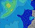 | 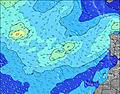 | 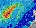 | 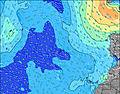 | 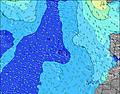 | ||||||||||||||
Wave Height (m) Direction Period (s) | N 8 | N 8 | NNE 8 | NNE 5 | NNE 6 | NNE 6 | NE 6 | NE 7 | NNE 7 | NE 7 | NNE 7 | NNE 7 | NNE 7 | NNE 7 | NNE 7 | NNE 7 | NNE 7 | NNE 7 | NNE 7 | NNE 7 | NNE 7 |
Wave Graph | |||||||||||||||||||||
33 | 21 | 105 | 61 | 84 | 99 | 162 | 163 | 218 | 284 | 237 | 311 | 302 | 302 | 344 | 279 | 271 | 279 | 271 | 265 | 314 | |
Wind (km/h) | |||||||||||||||||||||
Wind State on-shore cross-onshore cross-shore cross-offshore off-shore glassy | cross-on | cross-on | cross-on | cross-on | cross-on | cross-on | cross-on | cross-on | cross-on | cross-on | cross-on | cross-on | cross-on | cross-on | cross-on | on | on | on | on | on | on |
High Tide | 2:58PM2.32m | 3:28AM2.05m | 3:43PM2.33m | 4:13AM2.00m | 4:27PM2.28m | 4:57AM1.92m | 5:11PM2.16m | 5:40AM1.82m | 5:55PM1.99m | 6:26AM1.71m | 6:42PM1.80m | 7:16AM1.61m | 7:36PM1.62m | ||||||||
Low Tide | 9:18PM-0.05m | 9:24AM0.10m | 10:03PM-0.02m | 10:07AM0.15m | 10:47PM0.07m | 10:50AM0.23m | 11:30PM0.20m | 11:34AM0.35m | 00:14AM0.34m | 12:21PM0.49m | 00:59AM0.49m | 1:15PM0.62m | 1:52AM0.62m | ||||||||
7:15 | — | — | 7:15 | — | — | 7:16 | — | — | 7:16 | — | — | 7:16 | — | — | 7:18 | — | — | 7:18 | — | — | |
— | — | 9:00 | — | — | 9:00 | — | — | 9:00 | — | — | 9:00 | — | — | 9:00 | — | 8:59 | — | — | 8:59 | — | |
mm | — | — | — | — | — | — | — | — | — | — | — | — | — | — | — | — | — | — | — | — | — |
Temp °C | 24 | 25 | 23 | 24 | 25 | 23 | 24 | 24 | 22 | 23 | 24 | 22 | 23 | 23 | 22 | 23 | 23 | 22 | 23 | 23 | 22 |
Feels °C | 23 | 24 | 23 | 24 | 25 | 23 | 24 | 23 | 21 | 22 | 23 | 21 | 21 | 21 | 21 | 22 | 21 | 21 | 22 | 22 | 22 |
Swell 1 Height (m) Direction Period (s) | N 8 | N 8 | NW 7 | WNW 9 | NW 9 | NW 8 | S 12 | SW 19 | S 11 | SW 18 | SSW 18 | S 17 | SSW 16 | SSW 16 | SSW 16 | SSW 14 | SSW 15 | SSW 14 | SSW 13 | SSW 13 | SSW 12 |
33 | 21 | 2 | 8 | 3 | 3 | 3 | 15 | 2 | 12 | 30 | 6 | 25 | 25 | 24 | 21 | 21 | 20 | 17 | 17 | 15 | |
Swell 2 Height (m) Direction Period (s) | WNW 8 | NW 7 | NW 9 | S 12 | S 14 | S 13 | NW 8 | S 12 | S 19 | S 11 | S 11 | NW 9 | NW 9 | NW 8 | S 9 | NW 8 | S 12 | NW 7 | NW 9 | NW 11 | NW 10 |
7 | 9 | 3 | 3 | 4 | 3 | 3 | 3 | 7 | 2 | 2 | 3 | 3 | 3 | 2 | 3 | 3 | 2 | 3 | 5 | 4 | |
Swell 3 Height (m) Direction Period (s) | SSW 13 | SSW 12 | NW 8 | S 15 | N 11 | N 10 | S 21 | W 8 | NW 8 | W 9 | — | S 10 | S 10 | S 10 | NW 8 | S 9 | S 9 | N 9 | NW 11 | N 8 | S 8 |
17 | 15 | 2 | 4 | 2 | 2 | 9 | 1 | 2 | 1 | — | 2 | 2 | 2 | 3 | 2 | 2 | 2 | 5 | 1 | 1 | |
Wind waves Height (m) Direction Period (s) | NE 4 | NE 4 | NNE 8 | NNE 5 | NNE 6 | NNE 6 | NE 6 | NE 7 | NNE 7 | NE 7 | NNE 7 | NNE 7 | NNE 7 | NNE 7 | NNE 7 | NNE 7 | NNE 7 | NNE 7 | NNE 7 | NNE 7 | NNE 7 |
8 | 12 | 105 | 61 | 84 | 99 | 162 | 163 | 218 | 284 | 237 | 311 | 302 | 302 | 344 | 279 | 271 | 279 | 271 | 265 | 314 | |
Nearest Offshore or Glassy | |||||||||||||||||||||
Distance (km) | 45 | 105 | 79 | 105 | 525 | 45 | 562 | 44 | 62 | 45 | 44 | 45 | 45 | 105 | 105 | 45 | 45 | 45 | 44 | 105 | 62 |
Best forecast wave conditions in Gran Canaria | |||||||||||||||||||||
Best forecast wave conditions in Spain (Africa) | |||||||||||||||||||||
Header Global | |||||||||||||||||||||
- Map Icons:
 Break
Break Live Wave Height (m)
 Live Wind Speed (km/h)
 Surf Rating (10 Max)
 Ocean Swells (m)
- Wind Speed (km/h)


FREE! Surf-Forecast.com widget for your website
The surf report / weather widget below is available to embed on third party websites free of charge and provides a summary of our Bocabarranco surf forecast. Simply grab the html code snippet that we provide and paste it into your own site. You can choose your preferred language and metric/imperial units for the surf forecast feed to suit users of your site. Click here to get the code.
Information about the Bocabarranco Surf forecast
The above surf forecast table for Bocabarranco provides essential information for determining whether the surfing conditions will be good over the next 16 days. A general guide to surfing at Bocabarranco can be found by selecting the local surf guide option on the grey menu. Our Bocabarranco surf forecast is unique since it includes wave energy (power) that defines the real feel of the surf rather than just the height or the period. If you surf the same spot (Bocabarranco) regularly then make a mental note of the wave energy from the surf forecast table each time you go. Very soon you may start to choose your surf days based on the wave energy alone combined with our forecast of favourable offshore wind conditions. Our star ratings will help here and of course you will also find the usual wave height and period predictions on our surf forecasts as well as a full break down of the swell components under our advanced users option (to reveal that, click the little Einstein character under the tide times).
Further information to help with frequently asked questions about our surf forecast for Bocabarranco may be found under the help tab on the top menu and also by moving your mouse over the question marks on the surf forecast table itself. Please always bear in mind that the forecast is for near-shore open water and local factors at each surf break influence the actual breaking wave height, such as the beach / reef profile, water depths offshore and shelter.
Bocabarranco is 2 km (1 miles) from Galdar. If you plan a holiday in Gran Canaria, look for hotels and other accommodation in Galdar. Galdar has rooms for a wide range of budgets as well as car hire and transport links.
 Nearest