

Surf Forecasts:

Rock Island surf forecast from 3 Aug 2026:
- Best quality surf: Wednesday 5 Aug, 3PM (local time) - 10ft (3.0m), 16s period, SSE swell with offshore winds.
- Most powerful swell: Wednesday 5 Aug, 3PM (local time) - 10ft (3.0m), 16s period, SSE swell with 3,860 kJ wave energy.
- Next surfable swell (1★+): Wednesday 5 Aug, 3PM (local time) - 10ft (3.0m), 16s period with SSE swell.
Best Forecast Surf Conditions for Rock Island this week:
The surf forecast for Rock Island over the next 16 days: The first swell (rated 1 star or higher) is forecast to arrive on Wednesday (Aug 05) at 3PM. The primary swell is predicted to be 3.0m and 16s period. The wind is predicted to be offshore as the swell arrives.
The most powerful waves expected at Rock Island in the next 16 days are 3.0m 16s and forecast to arrive on Wednesday (Aug 05) at 3PM. Winds are predicted to be offshore at the time the swell arrives. The largest open ocean swell (not directed at the beach) is 1.0m 4s period and expected on Wednesday (Aug 05) at 9AM.
| Wave Type | Time (JST) & Date | Wave Height & Period |
|---|---|---|
| Next good surf (1 star+) | 3PM (Wed 5th Aug) | 10ft (3.0m) 16s |
| Best Surf | 3PM (Wed 5th Aug) | 10ft (3.0m) 16s |
| Most Powerful | 3PM (Wed 5th Aug) | 10ft (3.0m) 16s |
Table - best surf conditions forecast for Rock Island over the next 16 days.
The Lowdown
Alright, Rusty here. Let’s get into it in feet and miles an hour.
The next couple of weeks start off slow and build into a solid swell window mid-week, with the standout coming mid-next week when it all comes together. There’s a gap of nearly three days at the start of the period with no decent recommendation, but then it kicks off from Monday the 3rd of August.
Monday the 3rd of August is a bit of a teaser. Rock Island is seeing a small, long-period groundswell coming from the SE at 2ft, with a period of 16 seconds. That’s a very long period for such a small wave, so don’t expect much push. The wind is a fresh offshore NNE at 30 mph, so the surface will be clean, but water temperature is a touch warmer than normal at 83°. The swell energy is weak here, coming in at 277. It’s surfable, but you’ll be working hard for little reward.
Tuesday the 4th of August shows a step up. The morning swell bumps to 5ft from the SE, still that long 17-second period. The combined energy jumps to 1098 (moderate strength). Winds are fresh offshore NNE at 30 mph, so it’s clean. This is a solid beginner to intermediate wave at Rock Island—clean, with enough push to get a proper ride. The afternoon sees the swell push to 6ft from the SE, with a NE wind at 30 mph going cross-off, keeping it fairly clean. Energy is building to 1614.
Wednesday the 5th of August is the standout of the whole run. The morning has 8ft of SSE swell with a 16-second period, and that offshore NNE wind at 30 mph continues. The combined swell energy is strong at 3413. This is excellent for experienced surfers—over 8ft, so it’s for the skilled crew only. The afternoon gets even better: 10ft from the SSE, offshore NE wind at 20 mph, and energy hitting 3860. Conditions are described as excellent for experienced surfers. Rock Island is a reef break, and with this long-period swell, it’ll be lined up and punchy. This is a true highlight.
Thursday the 6th of August still pumps. Morning sees 8ft from the S, moderate offshore NNE winds at 20 mph, and energy of 2588. That’s still strong. The afternoon turns a bit scratchy as the wind swings SE onshore at 15 mph, making things choppy at 8ft. The crowd at Rock Island is “sometimes,” so mid-week you might have it mostly to yourself.
Friday the 7th of August holds onto size but the wind is messy. The morning has 8ft S swell, cross-off ENE wind at 15 mph, and energy of 3208—still plenty of power. The afternoon gets a direct cross-shore SE wind at 20 mph that’ll chop it up. It’s a gear-shifter day.
Saturday the 8th of August drops a notch. Morning is 6ft from the SSW, light offshore NE wind at 10 mph, and clean. Energy is 1792, still moderate-strong. This is a great day for intermediates stepping down from the big stuff. Afternoon gets a cross-on S wind at 15 mph and gets lumpy.
From Sunday the 9th of August onward, the swell fades steadily. By Monday the 10th, it’s tiny with strong offshore wind at 40 mph that makes paddling hard. There’s a long flat spell from the 10th through to the 15th of August, with the odd knee-high wave and onshore winds at times. Not worth paddling out.
The run picks up again on Sunday the 16th of August with a new SE swell. 4ft from the SE, 13-second period, offshore NNE wind at 25 mph in the morning. Energy is 488. That’s surfable and clean. Then Monday the 17th of August looks promising: 4ft SE, 13 seconds, gentle offshore NE wind at 15 mph, and energy of 533. It’s a moderate, clean day for a longboard or fish.
After that, Tuesday the 18th of August drops back to small, ordinary surf. So overall, the clear winner is Wednesday the 5th of August—wind, swell, and direction all line up at Rock Island for the confident surfer.
Rusty.
Short Range ForecastMostly dry. Warm (max 28°C on Wed afternoon, min 23°C on Mon night). Mainly fresh winds. | Days 4-6 Weather SummaryModerate rain (total 18mm), heaviest on Thu night. Warm (max 30°C on Thu morning, min 24°C on Sat night). Wind will be generally light. | ||||||||||||||||||||
Monday 3 | Tuesday 4 | Wednesday 5 | Thursday 6 | Friday 7 | Saturday 8 | Sunday 9 | |||||||||||||||
AM | PM | Night | AM | PM | Night | AM | PM | Night | AM | PM | Night | AM | PM | Night | AM | PM | Night | AM | PM | Night | |
Swell Height Map |  |  |  | 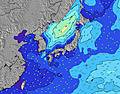 | 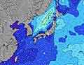 | 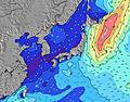 | 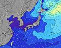 | ||||||||||||||
Wave Height (m) Direction Period (s) | SE 16 | SE 16 | SE 17 | SE 17 | SE 16 | SE 16 | SSE 16 | SSE 16 | SSE 15 | S 15 | S 16 | S 16 | S 16 | S 15 | S 14 | SSW 14 | SSW 14 | S 14 | SSW 14 | SSW 13 | SW 14 |
Wave Graph | |||||||||||||||||||||
258 | 448 | 671 | 1094 | 1611 | 2676 | 3413 | 3860 | 2749 | 2508 | 3272 | 3634 | 3025 | 2177 | 1691 | 1449 | 1139 | 849 | 646 | 539 | 164 | |
Wind (km/h) | |||||||||||||||||||||
Wind State on-shore cross-onshore cross-shore cross-offshore off-shore glassy | off | off | off | off | cross-off | off | off | off | off | off | cross-on | cross-off | cross-off | cross | cross | cross-off | cross-on | cross-off | off | cross-off | off |
High Tide | 8:21PM1.45m | 8:29AM1.35m | 8:48PM1.44m | 9:29AM1.26m | 9:16PM1.43m | 10:48AM1.17m | 9:49PM1.41m | 12:41PM1.13m | 10:30PM1.40m | 2:57PM1.19m | 11:28PM1.38m | 4:09PM1.28m | 00:45AM1.38m | ||||||||
Low Tide | 1:59PM0.44m | 2:29AM0.59m | 2:32PM0.59m | 3:17AM0.54m | 3:04PM0.75m | 4:14AM0.50m | 3:39PM0.90m | 5:21AM0.46m | 4:23PM1.04m | 6:37AM0.41m | 5:47PM1.15m | 7:52AM0.33m | 7:53PM1.19m | ||||||||
4:50 | — | — | 4:52 | — | — | 4:52 | — | — | 4:52 | — | — | 4:54 | — | — | 4:54 | — | — | 4:54 | — | — | |
— | 6:44 | — | — | 6:43 | — | — | 6:42 | — | — | 6:40 | — | — | 6:39 | — | — | 6:38 | — | — | 6:37 | — | |
mm | — | — | — | — | — | — | — | — | — | — | — | 7 | 4 | — | 7 | — | — | — | — | — | — |
Temp °C | 24 | 26 | 23 | 25 | 27 | 23 | 25 | 28 | 26 | 30 | 30 | 27 | 29 | 30 | 27 | 30 | 29 | 26 | 28 | 29 | 24 |
Feels °C | 23 | 24 | 20 | 21 | 24 | 20 | 23 | 28 | 27 | 32 | 31 | 29 | 31 | 31 | 29 | 32 | 30 | 27 | 25 | 24 | 20 |
Swell 1 Height (m) Direction Period (s) | SE 16 | SE 16 | SE 17 | SE 17 | SE 16 | SE 16 | SSE 16 | SSE 16 | SSE 15 | S 15 | S 16 | S 16 | S 16 | S 15 | S 14 | SSW 14 | SSW 14 | S 14 | SSW 14 | SSW 13 | S 10 |
258 | 448 | 671 | 1094 | 1611 | 2676 | 3413 | 3860 | 2749 | 2508 | 3272 | 3634 | 3025 | 2177 | 1691 | 1449 | 1139 | 849 | 646 | 539 | 94 | |
Swell 2 Height (m) Direction Period (s) | SE 22 | S 8 | E 14 | E 14 | E 13 | — | — | — | — | ESE 10 | ESE 10 | ESE 9 | ESE 10 | — | SSE 9 | SE 9 | ESE 12 | ESE 12 | ESE 13 | ESE 12 | SW 14 |
18 | 1 | 4 | 4 | 3 | — | — | — | — | 80 | 82 | 98 | 183 | — | 270 | 343 | 13 | 29 | 32 | 29 | 164 | |
Swell 3 Height (m) Direction Period (s) | S 8 | — | — | — | — | — | — | — | — | — | — | — | — | — | ESE 9 | — | ESE 12 | — | — | SE 16 | ESE 13 |
1 | — | — | — | — | — | — | — | — | — | — | — | — | — | 96 | — | 81 | — | — | 10 | 16 | |
Wind waves Height (m) Direction Period (s) | NE 3 | NE 3 | NE 3 | NE 3 | — | — | NNE 4 | — | — | — | — | — | — | — | — | — | — | — | — | — | NE 4 |
5 | 3 | 7 | 9 | — | — | 34 | — | — | — | — | — | — | — | — | — | — | — | — | — | 17 | |
Nearest Offshore or Glassy | |||||||||||||||||||||
Distance (km) | 470 | 38 | 145 | 145 | 38 | 491 | 488 | 0 | 0 | 0 | 2214 | 2 | 2289 | 54 | 77 | 0 | 54 | 12 | 2583 | 2214 | 565 |
Best forecast wave conditions in Kanagawa | |||||||||||||||||||||
Best forecast wave conditions in Japan | |||||||||||||||||||||
Header Global | |||||||||||||||||||||
- Map Icons:
 Break
Break Live Wave Height (m)
 Live Wind Speed (km/h)
 Surf Rating (10 Max)
 Ocean Swells (m)
- Wind Speed (km/h)
Latest Updates


FREE! Surf-Forecast.com widget for your website
The surf report / weather widget below is available to embed on third party websites free of charge and provides a summary of our Rock Island surf forecast. Simply grab the html code snippet that we provide and paste it into your own site. You can choose your preferred language and metric/imperial units for the surf forecast feed to suit users of your site. Click here to get the code.
Information about the Rock Island Surf forecast
The above surf forecast table for Rock Island provides essential information for determining whether the surfing conditions will be good over the next 16 days. A general guide to surfing at Rock Island can be found by selecting the local surf guide option on the grey menu. Our Rock Island surf forecast is unique since it includes wave energy (power) that defines the real feel of the surf rather than just the height or the period. If you surf the same spot (Rock Island) regularly then make a mental note of the wave energy from the surf forecast table each time you go. Very soon you may start to choose your surf days based on the wave energy alone combined with our forecast of favourable offshore wind conditions. Our star ratings will help here and of course you will also find the usual wave height and period predictions on our surf forecasts as well as a full break down of the swell components under our advanced users option (to reveal that, click the little Einstein character under the tide times).
Further information to help with frequently asked questions about our surf forecast for Rock Island may be found under the help tab on the top menu and also by moving your mouse over the question marks on the surf forecast table itself. Please always bear in mind that the forecast is for near-shore open water and local factors at each surf break influence the actual breaking wave height, such as the beach / reef profile, water depths offshore and shelter.
Rock Island is 3 km (2 miles) from the city of Kamakura. If you plan a holiday in Kanagawa, look for hotels and other accommodation in Kamakura. Kamakura has rooms for a wide range of budgets as well as car hire and transport links.
 Nearest