

Surf Forecasts:

Nantasket Beach surf forecast from 3 Aug 2026:
- Most powerful swell: Monday 3 Aug, 2PM (local time) - 2.5ft (0.7m), 7s period, SE swell with 52 kJ wave energy.
Best Forecast Surf Conditions for Nantasket Beach this week:
The most powerful waves expected at Nantasket Beach in the next 16 days are 0.7m 7s and forecast to arrive on Monday (Aug 03) at 2PM. Winds are predicted to be cross-offshore at the time the swell arrives. The largest open ocean swell (not directed at the beach) is 0.6m 5s period and expected on Monday (Aug 03) at 8PM.
| Wave Type | Time (EDT) & Date | Wave Height & Period |
|---|---|---|
| Next good surf (1 star+) | - | - |
| Best Surf | - | - |
| Most Powerful | 2PM (Mon 3rd Aug) | 2.5ft (0.7m) 7s |
Table - best surf conditions forecast for Nantasket Beach over the next 16 days.
The Lowdown
Alright folks, Rusty here. Gotta be straight with you – the next 16 days at Nantasket Beach are a tough watch. We’re looking at a long, flat stretch where the ocean just isn’t giving us anything to work with. The first real surf recommendation doesn't appear until much later in the window, so don't bother checking the cams for a while.
The overall pattern is brutally quiet, with the combined swell energy stuck at weak levels (26) at best during the first week. A tiny 2 ft SE swell with a short, weak period of 5 seconds rolls in on Monday, August 3rd, but it’s accompanied by a moderate breeze and a risk of thunderstorms, making for a total write-off.
That sets the tone for the next week and a half. We get a string of days with nothing but ankle-biters – 0.3 ft to 0.7 ft – with the occasional glassy moment on Tuesday morning, August 12th, where the wind goes dead calm and the water is glassy. The swell is a pathetic 2 ft from the ENE at a 4-second period, so even though it’s clean, there’s no power. The combined energy sits at a measly 19. It’s a nice morning to be on the beach, but not on a board.
The only faint glimmer, and I mean *faint*, comes on Friday morning, August 14th. We get a glassy morning with a light SSW breeze, and a 1 ft ESE swell, period up to 6 seconds. The energy is still weak (18), but it’s the cleanest conditions we’ll see. The water temperature is about average for this time of year. Still, that’s a session for a longboard or a foamie, not a proper surf.
The truth is, Nantasket is exposed to the NE, and the swell we’re getting is small and from the SE or ESE. That, combined with the lack of any real size, means there’s nothing to get excited about. If you’re desperate for a paddle, the glassy morning on the 14th is your best bet, but that’s a low bar. Honestly, this setup looks more interesting for a kite surfer than for a paddle surfer, if the wind picks up.
Stay patient, lads. It’s a dead run.
- Rusty
Short Range ForecastHeavy rain (total 43mm), heaviest during Mon afternoon. Warm (max 30°C on Tue afternoon, min 18°C on Mon night). Wind will be generally light. | Days 5-7 Weather SummaryLight rain (total 4mm), mostly falling on Wed night. Warm (max 34°C on Fri afternoon, min 22°C on Wed night). Wind will be generally light. | ||||||||||||||||||
Monday 3 | Tuesday 4 | Wednesday 5 | Thursday 6 | Friday 7 | Saturday 8 | ||||||||||||||
Night | AM | PM | Night | AM | PM | Night | AM | PM | Night | AM | PM | Night | AM | PM | Night | AM | PM | Night | |
Swell Height Map |  |  |  |  | 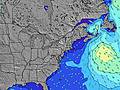 | 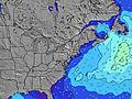 | 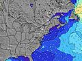 | ||||||||||||
Wave Height (m) Direction Period (s) | SE 4 | SE 5 | SE 8 | SE 8 | ESE 8 | ESE 6 | SE 7 | E 10 | SE 6 | SE 5 | E 9 | E 9 | E 10 | E 9 | E 9 | SE 8 | SE 8 | SE 8 | E 8 |
Wave Graph | |||||||||||||||||||
13 | 25 | 20 | 18 | 7 | 4 | 8 | 2 | 6 | 10 | 2 | 2 | 2 | 2 | 2 | 2 | 2 | 2 | 2 | |
Wind (km/h) | |||||||||||||||||||
Wind State on-shore cross-onshore cross-shore cross-offshore off-shore glassy | cross | cross-off | cross-off | off | off | cross-off | cross-off | cross | cross | cross-off | cross-off | cross-off | cross-off | cross-off | off | off | cross-off | cross-on | off |
High Tide | 2:50AM2.88m | 3:16PM2.90m | 3:34AM2.80m | 3:59PM2.96m | 4:24AM2.71m | 4:48PM2.99m | 5:20AM2.62m | 5:41PM3.02m | 6:20AM2.55m | 6:40PM3.05m | 7:23AM2.52m | 7:41PM3.08m | |||||||
Low Tide | 8:40PM0.19m | 9:00AM0.06m | 9:25PM0.15m | 9:43AM0.10m | 10:15PM0.13m | 10:29AM0.17m | 11:10PM0.12m | 11:22AM0.23m | 00:09AM0.11m | 12:20PM0.28m | 1:11AM0.09m | 1:20PM0.30m | 2:17AM0.03m | ||||||
— | 5:37 | — | — | 5:37 | — | — | 5:39 | — | — | 5:39 | — | — | 5:41 | — | — | 5:41 | — | — | |
8:01 | — | 8:00 | — | — | 7:59 | — | — | 7:58 | — | — | 7:57 | — | — | 7:55 | — | — | 7:53 | — | |
mm | 1 | 4 | 17 | 6 | — | — | — | 1 | 14 | 2 | — | — | — | — | — | 2 | — | — | — |
Temp °C | 25 | 24 | 23 | 22 | 26 | 30 | 25 | 23 | 22 | 23 | 28 | 32 | 28 | 30 | 34 | 30 | 28 | 31 | 30 |
Feels °C | 26 | 24 | 23 | 22 | 24 | 28 | 23 | 25 | 24 | 26 | 30 | 33 | 29 | 31 | 33 | 32 | 29 | 33 | 31 |
Swell 1 Height (m) Direction Period (s) | SE 4 | E 8 | SE 8 | SE 8 | ESE 8 | ESE 6 | SE 7 | SE 7 | E 8 | SE 5 | SE 6 | SE 8 | — | SE 7 | SE 8 | SE 8 | SE 8 | — | ESE 3 |
4 | 1 | 17 | 18 | 7 | 4 | 8 | 2 | 1 | 10 | 1 | 2 | — | 2 | 2 | 2 | 2 | — | 1 | |
Swell 2 Height (m) Direction Period (s) | E 9 | — | E 8 | E 8 | E 9 | SE 8 | E 10 | E 8 | E 9 | E 9 | E 8 | E 9 | SE 8 | E 9 | E 9 | E 8 | E 8 | SE 8 | E 8 |
1 | — | 1 | 1 | 2 | 3 | 2 | 1 | 2 | 2 | 1 | 2 | 2 | 2 | 2 | 1 | 1 | 2 | 1 | |
Swell 3 Height (m) Direction Period (s) | E 6 | — | — | — | E 9 | E 9 | — | E 10 | E 8 | E 8 | E 9 | E 9 | E 10 | — | SE 5 | E 8 | — | E 8 | SE 8 |
1 | — | — | — | 2 | 1 | — | 2 | 1 | 1 | 2 | 2 | 2 | — | 1 | 1 | — | 1 | 2 | |
Wind waves Height (m) Direction Period (s) | SE 4 | SE 5 | SSE 5 | — | — | — | — | — | SE 6 | — | — | SSE 3 | SSW 2 | — | — | — | — | — | — |
13 | 25 | 20 | — | — | — | — | — | 6 | — | — | 1 | 1 | — | — | — | — | — | — | |
Nearest Offshore or Glassy | |||||||||||||||||||
Distance (km) | 1256 | 1666 | 332 | 55 | 85 | 12 | 98 | 131 | 131 | 131 | 108 | 131 | 64 | 336 | 108 | 336 | 113 | 529 | 336 |
Best forecast wave conditions in Massachusetts | |||||||||||||||||||
Best forecast wave conditions in United States | |||||||||||||||||||
Header Global | |||||||||||||||||||
- Map Icons:
 Break
Break Live Wave Height (m)
 Live Wind Speed (km/h)
 Surf Rating (10 Max)
 Ocean Swells (m)
- Wind Speed (km/h)
Latest Updates


FREE! Surf-Forecast.com widget for your website
The surf report / weather widget below is available to embed on third party websites free of charge and provides a summary of our Nantasket Beach surf forecast. Simply grab the html code snippet that we provide and paste it into your own site. You can choose your preferred language and metric/imperial units for the surf forecast feed to suit users of your site. Click here to get the code.
Information about the Nantasket Beach Surf forecast
The above surf forecast table for Nantasket Beach provides essential information for determining whether the surfing conditions will be good over the next 16 days. A general guide to surfing at Nantasket Beach can be found by selecting the local surf guide option on the grey menu. Our Nantasket Beach surf forecast is unique since it includes wave energy (power) that defines the real feel of the surf rather than just the height or the period. If you surf the same spot (Nantasket Beach) regularly then make a mental note of the wave energy from the surf forecast table each time you go. Very soon you may start to choose your surf days based on the wave energy alone combined with our forecast of favourable offshore wind conditions. Our star ratings will help here and of course you will also find the usual wave height and period predictions on our surf forecasts as well as a full break down of the swell components under our advanced users option (to reveal that, click the little Einstein character under the tide times).
Further information to help with frequently asked questions about our surf forecast for Nantasket Beach may be found under the help tab on the top menu and also by moving your mouse over the question marks on the surf forecast table itself. Please always bear in mind that the forecast is for near-shore open water and local factors at each surf break influence the actual breaking wave height, such as the beach / reef profile, water depths offshore and shelter.
Nantasket Beach is 8 km (5 miles) from the city of Hingham. If you plan a vacation in Massachusetts, look for hotels and other accommodation in Hingham. Hingham has rooms for a wide range of budgets as well as car hire and transport links.
 Nearest