

Surf Forecasts:

La Caleta surf forecast from 18 Jul 2026:
- Most powerful swell: Saturday 25 Jul, 10AM (local time) - 8ft (2.4m), 8s period, NNE swell with 713 kJ wave energy.
Best Forecast Surf Conditions for La Caleta this week:
The most powerful waves expected at La Caleta in the next 16 days are 2.4m 8s and forecast to arrive on Saturday (Jul 25) at 10AM. Winds are predicted to be onshore at the time the swell arrives.
| Wave Type | Time (WEST) & Date | Wave Height & Period |
|---|---|---|
| Next good surf (1 star+) | - | - |
| Best Surf | - | - |
| Most Powerful | 10AM (Sat 25th Jul) | 8ft (2.4m) 8s |
Table - best surf conditions forecast for La Caleta over the next 16 days.
The Lowdown
Alright, surfers, Rusty here. Let's be straight with you – this is a tough one for the region. We're looking at La Caleta, a consistent reef break, but the conditions are just not cooperating for a good paddle session across the entire 16-day outlook.
The first chance for any surf is from Saturday the 18th of July, but don't get your hopes up. The swell is coming from the NNE, but it's being hammered by strong, onshore winds from the same direction. The water's sitting at 73°, which is a touch warmer than normal for this time of year, but that's the only good news. The wave energy is moderate early on, hitting 320 (moderate), but it's paired with a short, weak 7-second period and poor surf conditions. You'll be looking at a messy, blown-out sea.
This pattern just locks in. From Saturday through to Friday the 31st of July, it's the same story: consistent NNE swell, but constant onshore winds from the NNE to N, ramping up from a fresh breeze to a strong breeze. The swell builds from 6ft to 10ft, and the wave energy gets strong, peaking at 1627 (very strong) on the 29th of July. But with the wind howling directly onto the shore, these are expert-only, horrible conditions. The period barely climbs above 8 seconds, so there's no real shape to the waves. Honestly, for a beach or reef setup in this wind, it's looking more interesting for kite surfing than paddle surfing.
There's a slight change on the 1st and 2nd of August. The wind eases to a moderate breeze, and the swell drops to 5ft to 6ft, with the period finally stretching to 9 or 10 seconds. But the wind goes cross-onshore, making the surf choppy and "poor" according to the charts. The wave energy drops back to moderate, around 425 to 575. It's still not a good call.
Overall, there is not a single standout session in this 16-day window. The best of a bad bunch might be the very last day, Sunday the 2nd of August, with a smaller 5ft swell from the N and a 10-second period, but the cross-onshore wind will trash it. I wouldn't be paddling out for that. This is a blank run, plain and simple. Sometimes the forecasts can change, but for now, give the board a rest.
Rusty.
Short Range ForecastMostly dry. Warm (max 21°C on Sat morning, min 20°C on Sat morning). Mainly strong winds. | Days 4-6 Weather SummaryMostly dry. Warm (max 22°C on Tue afternoon, min 20°C on Tue night). Mainly strong winds. | ||||||||||||||||||||
Saturday 18 | Sunday 19 | Monday 20 | Tuesday 21 | Wednesday 22 | Thursday 23 | Friday 24 | |||||||||||||||
AM | PM | Night | AM | PM | Night | AM | PM | Night | AM | PM | Night | AM | PM | Night | AM | PM | Night | AM | PM | Night | |
Swell Height Map |  |  | 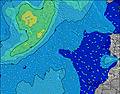 | 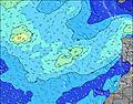 | 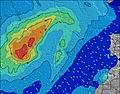 | 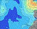 | 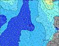 | ||||||||||||||
Wave Height (m) Direction Period (s) | NNE 7 | NNE 7 | NNE 7 | NNE 7 | NNE 7 | NNE 7 | NNE 8 | NNE 8 | NNE 8 | NNE 8 | NNE 7 | NNE 7 | NNE 7 | NNE 7 | NNE 7 | NNE 8 | NNE 8 | NNE 8 | NNE 8 | NNE 8 | NNE 8 |
Wave Graph | |||||||||||||||||||||
311 | 286 | 315 | 418 | 418 | 469 | 606 | 566 | 531 | 512 | 440 | 404 | 414 | 414 | 456 | 540 | 528 | 526 | 555 | 589 | 636 | |
Wind (km/h) | |||||||||||||||||||||
Wind State on-shore cross-onshore cross-shore cross-offshore off-shore glassy | on | on | on | on | on | on | on | on | on | on | on | on | on | on | on | on | on | cross-on | on | on | cross-on |
High Tide | 5:24PM2.45m | 5:53AM2.10m | 6:09PM2.26m | 6:38AM1.97m | 6:56PM2.06m | 7:29AM1.85m | 7:50PM1.86m | 8:28AM1.75m | 8:56PM1.71m | 9:38AM1.71m | 10:14PM1.64m | 10:51AM1.74m | 11:27PM1.67m | ||||||||
Low Tide | 11:02AM0.27m | 11:42PM0.23m | 11:46AM0.40m | 00:25AM0.40m | 12:34PM0.55m | 1:11AM0.57m | 1:28PM0.70m | 2:03AM0.72m | 2:34PM0.81m | 3:08AM0.81m | 3:56PM0.85m | 4:23AM0.84m | 5:13PM0.80m | ||||||||
7:05 | — | — | 7:07 | — | — | 7:07 | — | — | 7:07 | — | — | 7:07 | — | — | 7:09 | — | — | 7:09 | — | — | |
— | 8:53 | — | — | 8:52 | — | — | 8:52 | — | — | 8:52 | — | — | 8:52 | — | — | 8:51 | — | — | 8:51 | — | |
mm | — | — | — | — | — | — | — | — | — | — | — | — | — | — | — | — | — | — | — | — | — |
Temp °C | 21 | 21 | 20 | 21 | 21 | 20 | 21 | 21 | 21 | 21 | 22 | 20 | 21 | 21 | 21 | 22 | 22 | 21 | 22 | 22 | 21 |
Feels °C | 19 | 18 | 17 | 18 | 17 | 16 | 17 | 17 | 17 | 17 | 19 | 17 | 17 | 17 | 18 | 20 | 20 | 19 | 19 | 19 | 18 |
Swell 1 Height (m) Direction Period (s) | WNW 8 | WNW 8 | WNW 8 | WNW 9 | WNW 9 | WNW 8 | WNW 8 | WNW 8 | WNW 8 | WNW 11 | NW 11 | NW 11 | NW 10 | WNW 10 | NW 10 | NW 9 | NW 9 | WNW 9 | WNW 9 | WNW 8 | NNE 8 |
6 | 6 | 6 | 16 | 15 | 14 | 13 | 11 | 6 | 13 | 30 | 29 | 25 | 37 | 23 | 21 | 21 | 16 | 7 | 7 | 636 | |
Swell 2 Height (m) Direction Period (s) | W 12 | W 11 | NW 10 | — | — | N 11 | — | W 13 | NNW 9 | NW 8 | — | NW 8 | WNW 8 | — | — | — | — | — | — | — | WNW 8 |
3 | 2 | 4 | — | — | 2 | — | 3 | 8 | 3 | — | 3 | 6 | — | — | — | — | — | — | — | 7 | |
Swell 3 Height (m) Direction Period (s) | — | — | — | — | — | — | — | — | NW 12 | W 9 | — | — | — | — | — | — | — | — | — | — | WNW 8 |
— | — | — | — | — | — | — | — | 6 | 2 | — | — | — | — | — | — | — | — | — | — | 7 | |
Wind waves Height (m) Direction Period (s) | NNE 7 | NNE 7 | NNE 7 | NNE 7 | NNE 7 | NNE 7 | NNE 8 | NNE 8 | NNE 8 | NNE 8 | NNE 7 | NNE 7 | NNE 7 | NNE 7 | NNE 7 | NNE 8 | NNE 8 | NNE 8 | NNE 8 | NNE 8 | — |
311 | 286 | 315 | 418 | 418 | 469 | 606 | 566 | 531 | 512 | 440 | 404 | 414 | 414 | 456 | 540 | 528 | 526 | 555 | 589 | — | |
Nearest Offshore or Glassy | |||||||||||||||||||||
Distance (km) | 256 | 231 | 256 | 256 | 331 | 335 | 326 | 330 | 256 | 256 | 331 | 331 | 331 | 331 | 331 | 331 | 331 | 332 | 231 | 534 | 38 |
Best forecast wave conditions in Lanzarote | |||||||||||||||||||||
Best forecast wave conditions in Spain (Africa) | |||||||||||||||||||||
Header Global | |||||||||||||||||||||
- Map Icons:
 Break
Break Live Wave Height (m)
 Live Wind Speed (km/h)
 Surf Rating (10 Max)
 Ocean Swells (m)
- Wind Speed (km/h)


FREE! Surf-Forecast.com widget for your website
The surf report / weather widget below is available to embed on third party websites free of charge and provides a summary of our La Caleta surf forecast. Simply grab the html code snippet that we provide and paste it into your own site. You can choose your preferred language and metric/imperial units for the surf forecast feed to suit users of your site. Click here to get the code.
Information about the La Caleta Surf forecast
The above surf forecast table for La Caleta provides essential information for determining whether the surfing conditions will be good over the next 16 days. A general guide to surfing at La Caleta can be found by selecting the local surf guide option on the grey menu. Our La Caleta surf forecast is unique since it includes wave energy (power) that defines the real feel of the surf rather than just the height or the period. If you surf the same spot (La Caleta) regularly then make a mental note of the wave energy from the surf forecast table each time you go. Very soon you may start to choose your surf days based on the wave energy alone combined with our forecast of favourable offshore wind conditions. Our star ratings will help here and of course you will also find the usual wave height and period predictions on our surf forecasts as well as a full break down of the swell components under our advanced users option (to reveal that, click the little Einstein character under the tide times).
Further information to help with frequently asked questions about our surf forecast for La Caleta may be found under the help tab on the top menu and also by moving your mouse over the question marks on the surf forecast table itself. Please always bear in mind that the forecast is for near-shore open water and local factors at each surf break influence the actual breaking wave height, such as the beach / reef profile, water depths offshore and shelter.
La Caleta is 8 km (5 miles) from Teguise. If you plan a holiday in Lanzarote, look for hotels and other accommodation in Teguise. Teguise has rooms for a wide range of budgets as well as car hire and transport links.
 Nearest