

Surf Forecasts:

Kellys Cove surf forecast from 4 Jul 2026:
- Most powerful swell: Thursday 9 Jul, 8PM (local time) - 8ft (2.5m), 9s period, WNW swell with 1,157 kJ wave energy.
Best Forecast Surf Conditions for Kellys Cove this week:
The most powerful waves expected at Kellys Cove in the next 16 days are 2.5m 9s and forecast to arrive on Thursday (Jul 09) at 8PM. Winds are predicted to be cross-onshore at the time the swell arrives.
| Wave Type | Time (PDT) & Date | Wave Height & Period |
|---|---|---|
| Next good surf (1 star+) | - | - |
| Best Surf | - | - |
| Most Powerful | 8PM (Thu 9th Jul) | 8ft (2.5m) 9s |
Table - best surf conditions forecast for Kellys Cove over the next 16 days.
Updates in hr min s Forecast update imminent
Hey, Rusty here. Let’s break down Kellys Cove in feet and miles per hour for you.
The next couple of weeks are pretty grim, to be honest. The first week is a near-total washout. Winds are mostly cross-onshore or onshore, and the surf is choppy or poor. There’s some size – like the morning of Wednesday the 8th of July with 7ft from the NW – but that short 8-second period and cross-on breeze make it a mess. The combined energy is high (1419), but it doesn’t matter if the waves are junky.
The one bright spot – and I mean the only one – is the morning of Monday the 13th of July. The conditions go glassy with 4ft of WNW swell and a 9-second period. That’s clean, smooth, and surfable. Combined energy is moderate (382), but with zero wind, you’ll be stoked on whatever comes through. It’s an advanced spot, beach and reef, fairly consistent. Crowds are often, so expect a few locals, but for a glassy session, it’s worth the company.
Water temp is 62°F, which is much warmer than usual for this time of year – a big anomaly of 7°F, so you might not even need a full wetsuit.
After that Monday morning, it’s back to the same story: cross-on winds and rough conditions. A few glimmers in the second week – like Wednesday the 15th has a tiny 1ft swell from the west with a very long 21-second period, but the wind is onshore and ruins it. Bigger days like Wednesday the 8th (7ft) with strong cross-onshore winds would be better for kite surfing than paddling.
So, save your energy for the Monday the 13th glass-off. The rest is a waiting game.
Rusty
Short Range ForecastMostly dry. Very mild (max 16°C on Sat afternoon, min 11°C on Fri night). Wind will be generally light. | Days 5-7 Weather SummaryMostly dry. Very mild (max 15°C on Wed afternoon, min 11°C on Tue night). Wind will be generally light. | ||||||||||||||||||||
Saturday 4 | Sunday 5 | Monday 6 | Tuesday 7 | Wednesday 8 | Thursday 9 | Fri 10 | |||||||||||||||
Night | AM | PM | Night | AM | PM | Night | AM | PM | Night | AM | PM | Night | AM | PM | Night | AM | PM | Night | AM | PM | |
Swell Height Map | 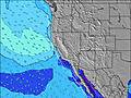 |  |  |  |  |  |  | 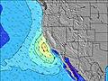 | |||||||||||||
Wave Height (m) Direction Period (s) | SW 16 | WNW 8 | SW 19 | SW 19 | SW 18 | SW 18 | SW 18 | SW 16 | SW 16 | SW 20 | SW 19 | SW 18 | SW 18 | SW 18 | WNW 8 | WNW 8 | WNW 9 | WNW 9 | WNW 9 | WNW 9 | WNW 9 |
Wave Graph | |||||||||||||||||||||
201 | 119 | 184 | 103 | 252 | 249 | 152 | 314 | 206 | 455 | 303 | 379 | 455 | 510 | 454 | 675 | 656 | 954 | 742 | 474 | 416 | |
Wind (km/h) | |||||||||||||||||||||
Wind State on-shore cross-onshore cross-shore cross-offshore off-shore glassy | cross-on | cross-on | cross-on | cross-on | cross-on | cross-on | cross-on | on | on | on | on | on | on | cross-on | on | on | on | on | cross-on | cross-on | cross-on |
High Tide | 1:28AM1.60m | 3:30PM1.50m | 2:17AM1.46m | 4:02PM1.57m | 3:14AM1.32m | 4:37PM1.66m | 4:26AM1.19m | 5:15PM1.76m | 5:58AM1.11m | 5:58PM1.87m | 7:45AM1.12m | 6:46PM1.97m | 9:17AM1.23m | 7:38PM2.07m | |||||||
Low Tide | 8:13AM-0.05m | 8:49PM0.86m | 8:49AM0.08m | 9:52PM0.74m | 9:27AM0.24m | 10:59PM0.59m | 10:11AM0.44m | 00:04AM0.39m | 11:04AM0.64m | 1:05AM0.17m | 12:07PM0.81m | 2:02AM-0.05m | 1:14PM0.94m | ||||||||
— | 5:52 | — | — | 5:52 | — | — | 5:54 | — | — | 5:54 | — | — | 5:54 | — | — | 5:56 | — | — | 5:56 | — | |
8:35 | — | 8:35 | — | — | 8:35 | — | — | 8:35 | — | — | 8:34 | — | — | 8:34 | — | — | 8:34 | — | — | 8:32 | |
mm | — | — | — | — | — | — | — | — | — | — | — | — | — | — | — | — | — | — | — | — | — |
Temp °C | 13 | 15 | 16 | 13 | 14 | 15 | 13 | 13 | 14 | 13 | 13 | 14 | 13 | 14 | 15 | 15 | 15 | 15 | 13 | 15 | 15 |
Feels °C | 10 | 13 | 12 | 9 | 12 | 11 | 10 | 10 | 10 | 9 | 10 | 9 | 8 | 12 | 10 | 11 | 14 | 12 | 9 | 13 | 11 |
Swell 1 Height (m) Direction Period (s) | WNW 8 | WNW 8 | WNW 8 | WNW 8 | WNW 8 | WNW 8 | WNW 8 | WNW 8 | WNW 12 | SW 20 | SW 16 | SW 18 | SW 18 | WNW 8 | SW 16 | SW 16 | SW 16 | SW 16 | SW 16 | WNW 9 | SW 15 |
119 | 119 | 100 | 100 | 125 | 103 | 103 | 128 | 111 | 455 | 196 | 379 | 455 | 291 | 443 | 310 | 437 | 306 | 291 | 474 | 273 | |
Swell 2 Height (m) Direction Period (s) | SW 16 | SW 14 | SSW 14 | SW 14 | SW 18 | SW 18 | SW 18 | SW 16 | SW 16 | SW 16 | SW 19 | SW 14 | SW 15 | SW 18 | — | SW 13 | — | — | SW 16 | SW 16 | SW 15 |
201 | 102 | 140 | 103 | 252 | 249 | 152 | 314 | 206 | 161 | 303 | 103 | 104 | 510 | — | 27 | — | — | 196 | 291 | 229 | |
Swell 3 Height (m) Direction Period (s) | SSW 21 | SW 20 | SW 19 | SW 19 | W 12 | WNW 13 | SW 13 | W 12 | SW 21 | WNW 11 | WNW 11 | S 8 | SSW 11 | — | — | SW 13 | — | — | — | — | — |
44 | 62 | 184 | 96 | 47 | 55 | 85 | 72 | 160 | 97 | 64 | 1 | 12 | — | — | 28 | — | — | — | — | — | |
Wind waves Height (m) Direction Period (s) | — | — | — | — | — | — | — | — | WNW 8 | WNW 7 | WNW 7 | WNW 7 | WNW 7 | NW 8 | WNW 8 | WNW 8 | WNW 9 | WNW 9 | WNW 9 | — | WNW 9 |
— | — | — | — | — | — | — | — | 113 | 151 | 157 | 209 | 343 | 473 | 454 | 675 | 656 | 954 | 742 | — | 416 | |
Nearest Offshore or Glassy | |||||||||||||||||||||
Distance (km) | 46 | 51 | 5 | 101 | 5 | 5 | 46 | 5 | 46 | 101 | 100 | 5 | 101 | 5 | 5 | 101 | 5 | 5 | 101 | 5 | 5 |
Best forecast wave conditions in Marin County | |||||||||||||||||||||
Best forecast wave conditions in United States | |||||||||||||||||||||
Header Global | |||||||||||||||||||||
- Map Icons:
 Break
Break Live Wave Height (m)
 Live Wind Speed (km/h)
 Surf Rating (10 Max)
 Ocean Swells (m)
- Wind Speed (km/h)


FREE! Surf-Forecast.com widget for your website
The surf report / weather widget below is available to embed on third party websites free of charge and provides a summary of our Kellys Cove surf forecast. Simply grab the html code snippet that we provide and paste it into your own site. You can choose your preferred language and metric/imperial units for the surf forecast feed to suit users of your site. Click here to get the code.
Information about the Kellys Cove Surf forecast
The above surf forecast table for Kellys Cove provides essential information for determining whether the surfing conditions will be good over the next 16 days. A general guide to surfing at Kellys Cove can be found by selecting the local surf guide option on the grey menu. Our Kellys Cove surf forecast is unique since it includes wave energy (power) that defines the real feel of the surf rather than just the height or the period. If you surf the same spot (Kellys Cove) regularly then make a mental note of the wave energy from the surf forecast table each time you go. Very soon you may start to choose your surf days based on the wave energy alone combined with our forecast of favourable offshore wind conditions. Our star ratings will help here and of course you will also find the usual wave height and period predictions on our surf forecasts as well as a full break down of the swell components under our advanced users option (to reveal that, click the little Einstein character under the tide times).
Further information to help with frequently asked questions about our surf forecast for Kellys Cove may be found under the help tab on the top menu and also by moving your mouse over the question marks on the surf forecast table itself. Please always bear in mind that the forecast is for near-shore open water and local factors at each surf break influence the actual breaking wave height, such as the beach / reef profile, water depths offshore and shelter.
Kellys Cove is 6 km (4 miles) from the city of San Francisco. If you plan a vacation in Marin County, look for hotels and other accommodation in San Francisco. San Francisco has rooms for a wide range of budgets as well as car hire and transport links.
 Nearest