

Surf Forecasts:

JP Luby Pier surf forecast from 28 Jul 2026:
- Best quality surf: Sunday 2 Aug, 7AM (local time) - 3.5ft (1.1m), 6s period, SSE swell with cross-offshore winds.
- Most powerful swell: Monday 3 Aug, 4AM (local time) - 5ft (1.5m), 6s period, S swell with 146 kJ wave energy.
- Next surfable swell (1★+): Sunday 2 Aug, 7AM (local time) - 3.5ft (1.1m), 6s period with SSE swell.
Best Forecast Surf Conditions for JP Luby Pier this week:
The surf forecast for JP Luby Pier over the next 16 days: The first swell (rated 1 star or higher) is forecast to arrive on Sunday (Aug 02) at 7AM. The primary swell is predicted to be 1.1m and 6s period with a secondary swell of 0.1m and 9s. The wind is predicted to be cross-offshore as the swell arrives.
The most powerful waves expected at JP Luby Pier in the next 16 days are 1.5m 6s and forecast to arrive on Monday (Aug 03) at 4AM. Winds are predicted to be cross-shore at the time the swell arrives.
| Wave Type | Time (CDT) & Date | Wave Height & Period |
|---|---|---|
| Next good surf (1 star+) | 7AM (Sun 2nd Aug) | 3.5ft (1.1m) 6s |
| Best Surf | 7AM (Sun 2nd Aug) | 3.5ft (1.1m) 6s |
| Most Powerful | 4AM (Mon 3rd Aug) | 5ft (1.5m) 6s |
Table - best surf conditions forecast for JP Luby Pier over the next 16 days.
The Lowdown
Alright, Rusty here. I’ve looked over the local surf outlook for the next 16 days. Gotta be straight with you: it’s a tough run. The forecast is showing a solid gap with no surf worth paddling out for. From right now, we’re looking at day after day of poor surf conditions. The first real chance of anything resembling a wave comes on August 4th, but even then, it’s not going to be anything to write home about.
Let’s break it down. For the first stretch, from July 27th straight through to August 3rd, it’s a write-off. The wind is relentless, cross-onshore and choppy, and the swell is weak. You’re looking at a combined wave energy of just 26 (July 27th) to 91 (August 3rd afternoon). That’s weak to barely moderate, but the wind just ruins it. The swell period is a short 5 to 6 seconds, so it’s all windswell, no grunt to it.
The first point where we see a little something is on Tuesday, August 4th. The morning shows a 4 ft swell from the SSE, with a period of 6 seconds and a combined energy of 110 (moderate). It’s still cross-onshore at 25 km/h (16 mph) from the SSE, so it’ll be choppy and lumpy. Not a standout, not a day to get excited about. The water temp is 83°F, which is about average for this time of year – no anomaly, so it’s just your usual warm summer water.
From there, the pattern holds. We get a sniff of offshore wind on Wednesday, August 5th afternoon and Thursday, August 6th morning at JP Luby Pier, with the wind turning onshore from the ESE. That’s a better direction for this spot, but the swell is still weak and short-period. On August 6th morning, the swell is 3 ft from the SE, period 6 seconds, energy 68, with a light breeze from the ESE. That’s the closest to clean you’ll get, but the waves will be small and weak.
Later in the run, Sunday, August 9th sees a 3 ft to 4 ft SSE swell, but the wind is back to a fresh cross-onshore, so it’s lumpy and messy. The combined energy maxes out at 68 that afternoon. Nothing is breaking through the wind.
Honestly, the only real standout in this whole 16-day window is the Thursday, August 6th morning session. The wind is light, from the ESE at 10 km/h (6 mph), which is onshore but light enough that it could be glassy early. The swell is 3 ft from the SE, period 7 seconds – the longest period we see in the whole forecast. That’s still a short period, but it’s the best of a bad bunch. The combined energy is 68, so weak, but the clean conditions might give you a fun, small wave if you’re on a log. It’s a beginner-friendly spot, so that’s a plus. Just remember, it’s a beach/pier setup, so don’t expect perfection.
Other than that, it’s a long, flat, windy slog. The swell directions are all from the SSE or SE, which is on the nose for this spot, and the wind never aligns properly to give us a clean, groomed wave. This is a tough period for the area. It’s not unusual – sometimes it just goes quiet. But the forecasts can change, so keep an eye on it.
Rusty.
Short Range ForecastMostly dry. Warm (max 28°C on Mon afternoon, min 27°C on Mon night). Mainly fresh winds. | Days 5-7 Weather SummaryMostly dry. Warm (max 28°C on Thu afternoon, min 27°C on Thu night). Mainly fresh winds. | |||||||||||||||||||
Mon 27 | Tuesday 28 | Wednesday 29 | Thursday 30 | Friday 31 | Saturday 1 | Sunday 2 | ||||||||||||||
PM | Night | AM | PM | Night | AM | PM | Night | AM | PM | Night | AM | PM | Night | AM | PM | Night | AM | PM | Night | |
Swell Height Map | 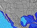 | 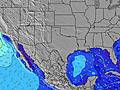 | 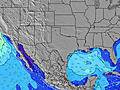 | 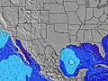 | 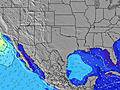 | 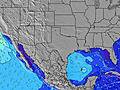 | 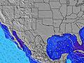 | |||||||||||||
Wave Height (m) Direction Period (s) | SE 5 | SSE 5 | SSE 5 | SSE 5 | SSE 5 | SSE 6 | SSE 6 | SSE 5 | SSE 5 | SE 5 | SSE 5 | SSE 5 | SSE 5 | SSE 5 | SE 5 | SE 5 | SSE 5 | SSE 6 | SSE 6 | SSE 6 |
Wave Graph | ||||||||||||||||||||
23 | 42 | 49 | 49 | 59 | 58 | 39 | 56 | 37 | 28 | 27 | 19 | 15 | 42 | 25 | 23 | 98 | 60 | 39 | 130 | |
Wind (km/h) | ||||||||||||||||||||
Wind State on-shore cross-onshore cross-shore cross-offshore off-shore glassy | cross-on | cross-on | cross-on | cross-on | cross-on | cross-on | cross-on | cross-on | cross-on | cross-on | cross-on | cross-on | cross-on | cross-on | cross-on | cross-on | cross | cross | cross-on | cross |
High Tide | 1:34PM0.05m | 1:58PM0.04m | 1:41PM0.03m | 12:44PM0.02m | 11:47AM0.02m | 10:57AM0.02m | ||||||||||||||
Low Tide | 1:42AM-0.09m | 2:23AM-0.09m | 2:55AM-0.07m | 3:16AM-0.06m | 3:24AM-0.04m | 3:09AM-0.02m | 6:47PM-0.02m | |||||||||||||
— | — | 6:48 | — | — | 6:50 | — | — | 6:50 | — | — | 6:50 | — | — | 6:50 | — | — | 6:52 | — | — | |
8:21 | — | — | 8:20 | — | — | 8:20 | — | — | 8:19 | — | — | 8:17 | — | — | 8:17 | — | — | 8:16 | — | |
mm | — | — | — | — | — | — | — | — | — | — | — | — | — | — | — | — | — | — | — | — |
Temp °C | 28 | 28 | 28 | 28 | 28 | 28 | 28 | 28 | 28 | 28 | 28 | 28 | 28 | 28 | 28 | 28 | 28 | 28 | 29 | 28 |
Feels °C | 30 | 28 | 29 | 28 | 29 | 30 | 29 | 29 | 31 | 30 | 30 | 31 | 29 | 29 | 30 | 29 | 27 | 33 | 31 | 29 |
Swell 1 Height (m) Direction Period (s) | E 7 | SE 9 | SE 9 | ESE 8 | ESE 8 | SE 8 | ESE 8 | SE 8 | SSE 5 | SE 8 | SE 8 | SE 7 | SE 7 | ESE 7 | SE 5 | — | — | SSE 6 | SE 9 | SE 10 |
1 | 3 | 3 | 7 | 6 | 3 | 6 | 3 | 37 | 2 | 2 | 2 | 2 | 5 | 25 | — | — | 60 | 3 | 4 | |
Swell 2 Height (m) Direction Period (s) | E 9 | — | — | — | — | ESE 7 | — | — | SE 8 | — | — | SE 7 | — | — | SE 6 | — | — | E 9 | — | — |
2 | — | — | — | — | 5 | — | — | 2 | — | — | 2 | — | — | 9 | — | — | 2 | — | — | |
Swell 3 Height (m) Direction Period (s) | — | — | — | — | — | — | — | — | — | — | — | — | — | — | — | — | — | — | — | — |
— | — | — | — | — | — | — | — | — | — | — | — | — | — | — | — | — | — | — | — | |
Wind waves Height (m) Direction Period (s) | SE 5 | SSE 5 | SSE 5 | SSE 5 | SSE 5 | SSE 6 | SSE 6 | SSE 5 | — | SE 5 | SSE 5 | SSE 5 | SSE 5 | SSE 5 | S 4 | SE 5 | SSE 5 | — | SSE 6 | SSE 6 |
23 | 42 | 49 | 49 | 59 | 58 | 39 | 56 | — | 28 | 27 | 19 | 15 | 42 | 10 | 23 | 98 | — | 39 | 130 | |
Nearest Offshore or Glassy | ||||||||||||||||||||
Distance (km) | 1139 | 1036 | 1040 | 1139 | 1036 | 1040 | 1141 | 1036 | 1040 | 1154 | 1024 | 1040 | 1139 | 1036 | 1040 | 1139 | 1036 | 21 | 1302 | 1036 |
Best forecast wave conditions in Texas | ||||||||||||||||||||
Best forecast wave conditions in United States | ||||||||||||||||||||
Header Global | ||||||||||||||||||||
- Map Icons:
 Break
Break Live Wave Height (m)
 Live Wind Speed (km/h)
 Surf Rating (10 Max)
 Ocean Swells (m)
- Wind Speed (km/h)


FREE! Surf-Forecast.com widget for your website
The surf report / weather widget below is available to embed on third party websites free of charge and provides a summary of our JP Luby Pier surf forecast. Simply grab the html code snippet that we provide and paste it into your own site. You can choose your preferred language and metric/imperial units for the surf forecast feed to suit users of your site. Click here to get the code.
Information about the JP Luby Pier Surf forecast
The above surf forecast table for JP Luby Pier provides essential information for determining whether the surfing conditions will be good over the next 16 days. A general guide to surfing at JP Luby Pier can be found by selecting the local surf guide option on the grey menu. Our JP Luby Pier surf forecast is unique since it includes wave energy (power) that defines the real feel of the surf rather than just the height or the period. If you surf the same spot (JP Luby Pier) regularly then make a mental note of the wave energy from the surf forecast table each time you go. Very soon you may start to choose your surf days based on the wave energy alone combined with our forecast of favourable offshore wind conditions. Our star ratings will help here and of course you will also find the usual wave height and period predictions on our surf forecasts as well as a full break down of the swell components under our advanced users option (to reveal that, click the little Einstein character under the tide times).
Further information to help with frequently asked questions about our surf forecast for JP Luby Pier may be found under the help tab on the top menu and also by moving your mouse over the question marks on the surf forecast table itself. Please always bear in mind that the forecast is for near-shore open water and local factors at each surf break influence the actual breaking wave height, such as the beach / reef profile, water depths offshore and shelter.
JP Luby Pier is 27 km (17 miles) from Corpus Christi. If you plan a vacation in Texas, look for hotels and other accommodation in Corpus Christi. Corpus Christi has rooms for a wide range of budgets as well as car hire and transport links.
 Nearest