

Surf Forecasts:

Teacapan surf forecast from 29 Jul 2026:
- Best quality surf: Wednesday 29 Jul, 5AM (local time) - 5ft (1.6m), 16s period, SW swell with cross-offshore winds.
- Most powerful swell: Wednesday 29 Jul, 5AM (local time) - 5ft (1.6m), 16s period, SW swell with 1,239 kJ wave energy.
- Next surfable swell (1★+): Wednesday 29 Jul, 5AM (local time) - 5ft (1.6m), 16s period with SW swell.
Best Forecast Surf Conditions for Teacapan this week:
The surf forecast for Teacapan over the next 16 days: The first swell (rated 1 star or higher) is forecast to arrive on Wednesday (Jul 29) at 5AM. The primary swell is predicted to be 1.6m and 16s period with a secondary swell of 1.0m and 10s. The wind is predicted to be cross-offshore as the swell arrives.
The most powerful waves expected at Teacapan in the next 16 days are 1.6m 16s and forecast to arrive on Wednesday (Jul 29) at 5AM. Winds are predicted to be cross-offshore at the time the swell arrives.
| Wave Type | Time (MST) & Date | Wave Height & Period |
|---|---|---|
| Next good surf (1 star+) | 5AM (Wed 29th Jul) | 5ft (1.6m) 16s |
| Best Surf | 5AM (Wed 29th Jul) | 5ft (1.6m) 16s |
| Most Powerful | 5AM (Wed 29th Jul) | 5ft (1.6m) 16s |
Table - best surf conditions forecast for Teacapan over the next 16 days.
The Lowdown
Alright folks, Rusty here. Let’s get straight into it for Teacapan. These next couple of weeks are looking pretty slim, so don’t get your hopes up too high.
The best window we’ve got is right at the start. Wednesday morning, July 29th, we’ve got a long-period groundswell pushing in from the SW at 4ft, with a period of 16 seconds. That’s a proper groundswell for this point/river setup. The energy is moderate, sitting at 897, and while the wind is a light cross-onshore, it’s manageable. This is the standout of the whole outlook, but it’s still a marginal call for quality. The water temp is about average for the time of year, nothing unusual to report.
The afternoon of the 29th sees a similar 4ft SW swell, but there’s a risk of thunderstorms, so keep an eye on the sky.
After that, it’s a long, slow fade. From Thursday the 30th all the way through to the end of the first week, we’re looking at weak, fading swells from the SW, dropping from 3ft down to 1ft. The wind is mostly onshore or cross-onshore, and the energy drops into the two-digit range, which is weak. The surf quality is poor, and most days are rated as a no-go.
There’s a silver lining way out there on Friday morning, August 7th. We’ve got a 2ft SW swell with a very long period of 18 seconds and a light cross-offshore breeze. The energy is moderate at 326, and it’s described as “clean” and “expect good surf conditions.” That’s the best-looking session in the second week, but it’s a long way off and the swell is tiny. It’s promising for the wave shape, but don’t expect much size.
The rest of the period into mid-August stays small, with swells between 1ft and 2ft, mostly onshore winds, and poor to marginal conditions. There’s a long gap of several days, from the 30th of July right through to the 6th of August, with nothing really worth paddling out for.
For a spot that’s fairly consistent, this is a disappointing run. But it’s a point/river break, so when the swell is this small and the period is this long, the waves might be too straight and walled-up to be any fun anyway. The setup here looks more interesting for kite surfing than paddle surfing on most of these days.
Stay patient, and keep an eye on that Friday morning, August 7th window.
Rusty.
Short Range ForecastHeavy rain (total 23mm), heaviest during Tue night. Warm (max 31°C on Fri morning, min 26°C on Tue night). Wind will be generally light. | Days 5-7 Weather SummaryHeavy rain (total 30mm), heaviest during Sun night. Warm (max 31°C on Sat morning, min 25°C on Sun night). Wind will be generally light. | ||||||||||||||||||
Wednesday 29 | Thursday 30 | Friday 31 | Saturday 1 | Sunday 2 | Monday 3 | ||||||||||||||
Night | AM | PM | Night | AM | PM | Night | AM | PM | Night | AM | PM | Night | AM | PM | Night | AM | PM | Night | |
Swell Height Map |  |  |  | 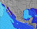 | 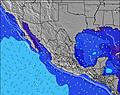 | 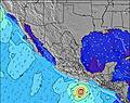 | 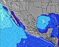 | ||||||||||||
Wave Height (m) Direction Period (s) | SW 16 | SW 16 | SW 16 | SW 15 | SW 14 | SW 14 | SW 14 | SW 13 | SW 13 | SW 13 | SW 12 | SW 12 | SW 13 | SW 13 | SW 13 | SW 13 | SW 13 | SW 13 | SW 12 |
Wave Graph | |||||||||||||||||||
1255 | 729 | 620 | 795 | 346 | 341 | 284 | 215 | 205 | 161 | 122 | 71 | 144 | 111 | 111 | 106 | 59 | 60 | 55 | |
Wind (km/h) | |||||||||||||||||||
Wind State on-shore cross-onshore cross-shore cross-offshore off-shore glassy | glassy | cross-on | on | cross-off | cross-on | on | cross-off | on | cross-on | off | on | cross-on | glassy | on | on | cross-off | on | on | cross-off |
High Tide | 9:23AM1.42m | 8:21PM1.77m | 9:44AM1.45m | 8:52PM1.76m | 10:05AM1.49m | 9:23PM1.70m | 10:26AM1.52m | 9:56PM1.60m | 10:49AM1.54m | 10:32PM1.46m | 11:14AM1.56m | 11:16PM1.29m | |||||||
Low Tide | 2:49AM0.12m | 2:24PM0.81m | 3:13AM0.13m | 2:54PM0.75m | 3:36AM0.18m | 3:26PM0.71m | 3:59AM0.26m | 4:02PM0.67m | 4:22AM0.37m | 4:41PM0.66m | 4:45AM0.50m | 5:29PM0.66m | |||||||
— | 5:33 | — | — | 5:33 | — | — | 5:33 | — | — | 5:33 | — | — | 5:33 | — | — | 5:35 | — | — | |
— | — | 6:45 | — | — | 6:45 | — | — | 6:44 | — | — | 6:44 | — | — | 6:43 | — | — | 6:43 | — | |
mm | 14 | — | 1 | 8 | — | — | — | — | — | 2 | — | — | 9 | — | — | 19 | — | — | 7 |
Temp °C | 29 | 30 | 30 | 29 | 30 | 29 | 29 | 31 | 30 | 28 | 31 | 31 | 26 | 30 | 30 | 28 | 29 | 30 | 28 |
Feels °C | 33 | 33 | 32 | 35 | 33 | 32 | 34 | 34 | 32 | 32 | 34 | 34 | 28 | 33 | 32 | 34 | 32 | 32 | 33 |
Swell 1 Height (m) Direction Period (s) | SW 16 | SW 16 | SW 16 | SW 15 | SW 14 | SW 14 | SW 14 | SW 13 | SW 13 | SW 13 | SW 12 | SW 12 | SW 13 | SW 13 | SW 13 | SW 13 | SW 13 | SW 13 | SW 12 |
1255 | 729 | 620 | 795 | 346 | 341 | 284 | 215 | 205 | 161 | 122 | 71 | 144 | 111 | 111 | 106 | 59 | 60 | 55 | |
Swell 2 Height (m) Direction Period (s) | SW 11 | SW 11 | WSW 12 | SSW 7 | WSW 11 | WSW 11 | WSW 10 | WSW 10 | WSW 9 | WSW 9 | W 8 | W 8 | W 8 | WSW 8 | WSW 8 | WSW 5 | WSW 5 | WSW 16 | WSW 5 |
249 | 163 | 171 | 9 | 138 | 164 | 102 | 100 | 64 | 68 | 37 | 34 | 33 | 19 | 19 | 9 | 8 | 51 | 8 | |
Swell 3 Height (m) Direction Period (s) | — | W 4 | S 7 | — | S 6 | S 6 | S 6 | W 22 | W 21 | SW 16 | SW 20 | SW 14 | WSW 19 | W 4 | WSW 18 | W 9 | W 8 | W 8 | WSW 16 |
— | 5 | 8 | — | 7 | 3 | 1 | 9 | 9 | 10 | 15 | 54 | 37 | 3 | 31 | 13 | 12 | 11 | 51 | |
Wind waves Height (m) Direction Period (s) | W 8 | — | W 4 | — | — | — | — | — | WSW 2 | — | — | W 2 | — | — | W 5 | — | — | W 5 | — |
1 | — | 6 | — | — | — | — | — | 1 | — | — | 1 | — | — | 7 | — | — | 12 | — | |
Nearest Offshore or Glassy | |||||||||||||||||||
Distance (km) | 0 | 19 | 200 | 0 | 125 | 200 | 0 | 19 | 200 | 0 | 19 | 200 | 0 | 19 | 200 | 0 | 19 | 384 | 0 |
Best forecast wave conditions in Sinaloa | |||||||||||||||||||
Best forecast wave conditions in Mexico | |||||||||||||||||||
Header Global | |||||||||||||||||||
- Map Icons:
 Break
Break Live Wave Height (m)
 Live Wind Speed (km/h)
 Surf Rating (10 Max)
 Ocean Swells (m)
- Wind Speed (km/h)


FREE! Surf-Forecast.com widget for your website
The surf report / weather widget below is available to embed on third party websites free of charge and provides a summary of our Teacapan surf forecast. Simply grab the html code snippet that we provide and paste it into your own site. You can choose your preferred language and metric/imperial units for the surf forecast feed to suit users of your site. Click here to get the code.
Information about the Teacapan Surf forecast
The above surf forecast table for Teacapan provides essential information for determining whether the surfing conditions will be good over the next 16 days. A general guide to surfing at Teacapan can be found by selecting the local surf guide option on the grey menu. Our Teacapan surf forecast is unique since it includes wave energy (power) that defines the real feel of the surf rather than just the height or the period. If you surf the same spot (Teacapan) regularly then make a mental note of the wave energy from the surf forecast table each time you go. Very soon you may start to choose your surf days based on the wave energy alone combined with our forecast of favourable offshore wind conditions. Our star ratings will help here and of course you will also find the usual wave height and period predictions on our surf forecasts as well as a full break down of the swell components under our advanced users option (to reveal that, click the little Einstein character under the tide times).
Further information to help with frequently asked questions about our surf forecast for Teacapan may be found under the help tab on the top menu and also by moving your mouse over the question marks on the surf forecast table itself. Please always bear in mind that the forecast is for near-shore open water and local factors at each surf break influence the actual breaking wave height, such as the beach / reef profile, water depths offshore and shelter.
Are you planning a holiday in Sinaloa? If you are looking for accommodation near Teacapan, camping, hotels and holiday cottages in Sinaloa, consider staying in Escuinapa de Hidalgo which is 33 km (20 miles) away. Other places in and around Sinaloa where you can find information about places to rent, and car hire include Acaponeta which is 42 km (26 miles) away, Mazatlan and Santiago Ixcuintla.
 Nearest