

Surf Forecasts:

Celestino surf forecast from 29 Jul 2026:
- Best quality surf: Wednesday 29 Jul, 8AM (local time) - 5ft (1.6m), 16s period, SSW swell with offshore winds.
- Most powerful swell: Wednesday 29 Jul, 2PM (local time) - 6ft (1.9m), 16s period, SSW swell with 1,721 kJ wave energy.
- Next surfable swell (1★+): Wednesday 29 Jul, 8AM (local time) - 5ft (1.6m), 16s period with SSW swell.
Best Forecast Surf Conditions for Celestino this week:
The surf forecast for Celestino over the next 16 days: The first swell (rated 1 star or higher) is forecast to arrive on Wednesday (Jul 29) at 8AM. The primary swell is predicted to be 1.6m and 16s period with a secondary swell of 1.2m and 11s. The wind is predicted to be offshore as the swell arrives.
The most powerful waves expected at Celestino in the next 16 days are 1.9m 16s and forecast to arrive on Wednesday (Jul 29) at 2PM. Winds are predicted to be onshore at the time the swell arrives. The largest open ocean swell (not directed at the beach) is 0.4m 3s period and expected on Tuesday (Aug 04) at 8AM.
| Wave Type | Time (MST) & Date | Wave Height & Period |
|---|---|---|
| Next good surf (1 star+) | 8AM (Wed 29th Jul) | 5ft (1.6m) 16s |
| Best Surf | 8AM (Wed 29th Jul) | 5ft (1.6m) 16s |
| Most Powerful | 2PM (Wed 29th Jul) | 6ft (1.9m) 16s |
Table - best surf conditions forecast for Celestino over the next 16 days.
The Lowdown
Right, let’s have a look at what’s on over the next couple of weeks. The swell is coming from the SSW, which is a good direction for Celestino, a point break that’s consistent and exposed. The water is sitting at 89°F which is much warmer than usual for this time of year – that’s a serious anomaly, you’ll be sweating in the lineup.
The first few days are a bit of a mixed bag, honestly. Wednesday the 29th has some solid energy pumping in – we’re talking about 5ft to 6ft of SSW swell with a very long period of 16 seconds (1433 to 1579 combined energy). That’s a serious groundswell. But the wind is on it or cross-on, and the forecast mentions “marginal surf forecast or questionable tide conditions,” so it’s not going to be clean. This kind of long-period swell can be tricky at a point break, but Celestino is a point, so it should handle it better than a beach. Still, it’s not a standout.
Thursday the 30th drops a little, with 5ft to 5ft, period dropping to 14 seconds, but the wind is cross-on or on again. The energy is still high (1231 to 1069), but the conditions are ordinary. Friday the 31st and Saturday the 1st of August see the swell drop to 3ft and 3ft, and the energy falls off a cliff (435 down to 283). The wind stays cross-on, and it’s all “poor surf conditions.” Sunday the 2nd and Monday the 3rd are tiny, 2ft, with hardly any energy left (162 to 222). It’s a real flat spell.
Now, there’s a glimmer on Tuesday the 4th of August. The swell is down to 1ft to 2ft, but the wind goes offshore from the NE in the morning, and then in the afternoon it goes glassy – zero wind. The energy is weak (141 to 121), but clean conditions on a point break? That’s a quiet session for the patient surfer. Don’t expect much push, but it’ll be pretty.
The real standout, the one you’ve been waiting for, is Saturday the 8th of August. The morning has that glassy feel again, with a light offshore from the ENE. The swell is 3ft from the SSW with a 16-second period (494 energy). It’s not huge, but the combination of a very long period groundswell, glassy conditions, and a point break that lines up with the swell direction – that’s the best on offer in this whole window. The afternoon gets ruined by a cross-on wind, so get in early.
After that, the rest of the outlook is a slow fade. Sunday the 9th has 3ft in the afternoon with 14-second period (512 energy), but cross-on wind. Monday the 10th has a super long period of 20 seconds, but the swell is only 2ft (569 energy) – that’s a lot of period for not much height, and it’s cross-on. From Tuesday the 11th to Thursday the 13th, it’s all 3ft to 3ft, period dropping from 18 to 15 seconds, with onshore or cross-on winds. The energy stays moderate (323 to 736), but the conditions are marginal at best. There’s nothing to get excited about.
So, bottom line: if you want the cleanest, most surfable wave, you’re looking at the morning of Saturday the 8th of August. It’s not a bomb, but it’ll be a fun, glassy session on a point break. The early part of the window has size but messy wind, and the second week is small and choppy. Enjoy the warm water.
Rusty.
Short Range ForecastLight rain (total 7mm), mostly falling on Wed night. Warm (max 31°C on Wed morning, min 27°C on Wed night). Wind will be generally light. | Days 4-6 Weather SummaryHeavy rain (total 29mm), heaviest during Mon night. Warm (max 31°C on Sun afternoon, min 25°C on Sun night). Wind will be generally light. | ||||||||||||||||||||
Wednesday 29 | Thursday 30 | Friday 31 | Saturday 1 | Sunday 2 | Monday 3 | Tuesday 4 | |||||||||||||||
AM | PM | Night | AM | PM | Night | AM | PM | Night | AM | PM | Night | AM | PM | Night | AM | PM | Night | AM | PM | Night | |
Swell Height Map |  |  |  | 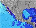 | 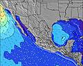 | 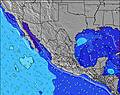 | 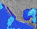 | ||||||||||||||
Wave Height (m) Direction Period (s) | SSW 16 | SSW 16 | SSW 15 | SSW 14 | SW 14 | SSW 14 | SSW 13 | SSW 13 | SSW 13 | SSW 12 | SSW 12 | SSW 13 | SSW 13 | SSW 13 | SSW 13 | SSW 13 | SSW 13 | SSW 13 | SW 16 | SSW 12 | SW 15 |
Wave Graph | |||||||||||||||||||||
1067 | 1479 | 1190 | 947 | 834 | 474 | 373 | 331 | 265 | 245 | 199 | 201 | 156 | 154 | 151 | 151 | 149 | 111 | 64 | 101 | 56 | |
Wind (km/h) | |||||||||||||||||||||
Wind State on-shore cross-onshore cross-shore cross-offshore off-shore glassy | on | cross-on | glassy | cross-on | on | cross-off | cross-on | on | glassy | cross-on | on | glassy | cross-on | cross-on | cross-off | cross-on | on | cross-off | off | glassy | glassy |
High Tide | 9:27AM1.40m | 8:19PM1.76m | 9:47AM1.43m | 8:50PM1.74m | 10:08AM1.46m | 9:22PM1.68m | 10:29AM1.50m | 9:55PM1.58m | 10:51AM1.53m | 10:33PM1.45m | 11:17AM1.55m | 11:18PM1.28m | 11:48AM1.56m | 00:25AM1.09m | |||||||
Low Tide | 2:23PM0.84m | 3:14AM0.15m | 2:54PM0.78m | 3:38AM0.19m | 3:27PM0.73m | 4:01AM0.27m | 4:03PM0.70m | 4:23AM0.38m | 4:44PM0.67m | 4:46AM0.51m | 5:33PM0.67m | 5:08AM0.65m | 6:37PM0.67m | ||||||||
5:35 | — | — | 5:35 | — | — | 5:35 | — | — | 5:35 | — | — | 5:37 | — | — | 5:37 | — | — | 5:37 | — | — | |
— | 6:52 | — | — | 6:51 | — | — | 6:51 | — | — | 6:50 | — | — | 6:50 | — | — | 6:49 | — | — | 6:47 | — | |
mm | — | — | 6 | — | — | — | — | — | 1 | — | — | 5 | — | 1 | 5 | — | — | 18 | 19 | 1 | 4 |
Temp °C | 31 | 31 | 30 | 31 | 31 | 29 | 31 | 31 | 29 | 30 | 30 | 28 | 30 | 31 | 27 | 30 | 31 | 28 | 25 | 28 | 27 |
Feels °C | 35 | 34 | 36 | 34 | 34 | 33 | 35 | 34 | 34 | 34 | 33 | 32 | 34 | 34 | 31 | 33 | 34 | 33 | 28 | 34 | 32 |
Swell 1 Height (m) Direction Period (s) | SSW 16 | SSW 16 | SSW 15 | SSW 14 | SW 14 | SSW 14 | SSW 13 | SSW 13 | SSW 13 | SSW 12 | SSW 12 | SSW 13 | SSW 13 | SSW 13 | SSW 13 | SSW 13 | SSW 13 | SSW 13 | SSW 12 | SSW 12 | SSW 12 |
1067 | 1479 | 1190 | 947 | 834 | 474 | 373 | 331 | 265 | 245 | 199 | 201 | 156 | 154 | 151 | 151 | 149 | 111 | 60 | 101 | 56 | |
Swell 2 Height (m) Direction Period (s) | SSW 11 | S 7 | WSW 12 | SW 12 | SW 11 | SW 9 | SW 9 | SW 8 | SW 8 | WSW 8 | WSW 7 | SW 4 | SW 5 | SW 5 | WSW 5 | SW 5 | SW 5 | SW 16 | SW 16 | SSW 9 | SW 15 |
317 | 16 | 247 | 273 | 224 | 62 | 59 | 57 | 31 | 23 | 21 | 4 | 12 | 13 | 4 | 7 | 8 | 66 | 64 | 15 | 54 | |
Swell 3 Height (m) Direction Period (s) | SW 14 | SW 12 | SSW 7 | S 12 | S 12 | S 6 | S 6 | S 6 | SW 21 | SW 20 | SSW 20 | WSW 7 | SSW 18 | SSW 18 | SW 18 | S 12 | SW 16 | SW 4 | SSW 9 | WSW 4 | S 9 |
49 | 75 | 16 | 11 | 11 | 3 | 3 | 1 | 18 | 15 | 37 | 5 | 31 | 31 | 49 | 3 | 65 | 4 | 16 | 2 | 13 | |
Wind waves Height (m) Direction Period (s) | — | WSW 5 | — | — | — | — | — | — | — | — | WSW 4 | — | — | — | S 3 | SSE 3 | — | — | SSE 3 | S 3 | — |
— | 9 | — | — | — | — | — | — | — | — | 4 | — | — | — | 1 | 1 | — | — | 1 | 3 | — | |
Nearest Offshore or Glassy | |||||||||||||||||||||
Distance (km) | 79 | 302 | 0 | 204 | 310 | 0 | 204 | 372 | 0 | 204 | 622 | 0 | 204 | 302 | 0 | 204 | 262 | 0 | 0 | 0 | 0 |
Best forecast wave conditions in Sinaloa | |||||||||||||||||||||
Best forecast wave conditions in Mexico | |||||||||||||||||||||
Header Global | |||||||||||||||||||||
- Map Icons:
 Break
Break Live Wave Height (m)
 Live Wind Speed (km/h)
 Surf Rating (10 Max)
 Ocean Swells (m)
- Wind Speed (km/h)


FREE! Surf-Forecast.com widget for your website
The surf report / weather widget below is available to embed on third party websites free of charge and provides a summary of our Celestino surf forecast. Simply grab the html code snippet that we provide and paste it into your own site. You can choose your preferred language and metric/imperial units for the surf forecast feed to suit users of your site. Click here to get the code.
Information about the Celestino Surf forecast
The above surf forecast table for Celestino provides essential information for determining whether the surfing conditions will be good over the next 16 days. A general guide to surfing at Celestino can be found by selecting the local surf guide option on the grey menu. Our Celestino surf forecast is unique since it includes wave energy (power) that defines the real feel of the surf rather than just the height or the period. If you surf the same spot (Celestino) regularly then make a mental note of the wave energy from the surf forecast table each time you go. Very soon you may start to choose your surf days based on the wave energy alone combined with our forecast of favourable offshore wind conditions. Our star ratings will help here and of course you will also find the usual wave height and period predictions on our surf forecasts as well as a full break down of the swell components under our advanced users option (to reveal that, click the little Einstein character under the tide times).
Further information to help with frequently asked questions about our surf forecast for Celestino may be found under the help tab on the top menu and also by moving your mouse over the question marks on the surf forecast table itself. Please always bear in mind that the forecast is for near-shore open water and local factors at each surf break influence the actual breaking wave height, such as the beach / reef profile, water depths offshore and shelter.
Celestino is 89 km (55 miles) from Mazatlan. If you plan a holiday in Sinaloa, look for hotels and other accommodation in Mazatlan. Mazatlan has rooms for a wide range of budgets as well as car hire and transport links.
 Nearest