

Surf Forecasts:

Hunting Island surf forecast from 1 Aug 2026:
- Most powerful swell: Sunday 2 Aug, 8PM (local time) - 6ft (1.8m), 6s period, S swell with 239 kJ wave energy.
Best Forecast Surf Conditions for Hunting Island this week:
The most powerful waves expected at Hunting Island in the next 16 days are 1.8m 6s and forecast to arrive on Sunday (Aug 02) at 8PM. Winds are predicted to be cross-offshore at the time the swell arrives. The largest open ocean swell (not directed at the beach) is 1.8m 6s period and expected on Sunday (Aug 02) at 11PM.
| Wave Type | Time (EDT) & Date | Wave Height & Period |
|---|---|---|
| Next good surf (1 star+) | - | - |
| Best Surf | - | - |
| Most Powerful | 8PM (Sun 2nd Aug) | 6ft (1.8m) 6s |
Table - best surf conditions forecast for Hunting Island over the next 16 days.
The Lowdown
Alright, let’s get real about the next two weeks at Hunting Island. Right now, things are looking pretty flat and messy. The water is cranking at 87° with a temperature anomaly of 5°, which is much warmer than normal for this time of year. Feels more like a bath than the ocean.
The whole 16-day window is a struggle. There’s nothing on the cards for the first week really – from Saturday the 1st right through to the middle of the month, the surf is tiny and the conditions are all over the place. You’re looking at swell heights barely scraping 3 ft, with periods mostly under 8 seconds, and the combined energy rarely breaks out of the weak range. Winds are a constant problem – cross-onshore, choppy, or just plain messy. There’s a brief flicker of something on Sunday the 2nd afternoon with a 5 ft swell from the south, but the period is a short 5 seconds and the wind is a fresh 22 mph cross-off. It’s clean but weak and won’t hold any shape. Not worth paddling out for.
The only real standout comes in the second week. On the morning of Thursday the 13th of August, things finally line up. The wind swings offshore from the west-southwest at a gentle 9 mph, making for clean, glassy conditions. The swell is still small – 2 ft from the southeast with an 8-second period – but the energy climbs to 69 (still weak, but it’s the best we’ll see). The break is exposed to the east and the optimum swell direction is east, so we’re getting what little there is straight on. It’s a beginner-friendly spot, fairly consistent, and with the offshore wind, it’ll be the cleanest surf of the whole forecast. Crowds are possible, but honestly, with this tiny swell, I doubt many will show.
After that, it’s back to the doldrums. The rest of the 16 days are a write-off – tiny waves, poor wind, and often stormy skies. Surfable waves but very ordinary conditions is the best we get, and that’s only for one session.
So, bottom line: if you’re desperate, hit Hunting Island on the morning of the 13th of August for a little 2 ft southeast swell with clean offshore winds. It’s not going to be epic, but it’s the only real chance in a very flat two weeks.
Rusty.
Short Range ForecastHeavy rain (total 26mm), heaviest during Mon morning. Warm (max 29°C on Sat morning, min 25°C on Sat night). Winds increasing (light winds from the WSW on Sat night, fresh winds from the SSW by Sun afternoon). | Days 4-6 Weather SummaryModerate rain (total 11mm), heaviest on Tue morning. Warm (max 29°C on Wed afternoon, min 26°C on Tue morning). Wind will be generally light. | ||||||||||||||||||||
Saturday 1 | Sunday 2 | Monday 3 | Tuesday 4 | Wednesday 5 | Thursday 6 | Friday 7 | |||||||||||||||
AM | PM | Night | AM | PM | Night | AM | PM | Night | AM | PM | Night | AM | PM | Night | AM | PM | Night | AM | PM | Night | |
Swell Height Map | 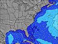 | 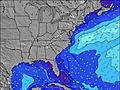 | 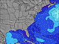 | 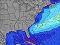 | 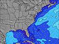 | 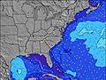 | 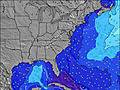 | ||||||||||||||
Wave Height (m) Direction Period (s) | SE 6 | ESE 9 | S 4 | SE 7 | S 5 | SE 8 | SE 7 | S 6 | S 7 | SE 7 | ESE 7 | ESE 7 | SE 7 | SE 7 | SE 7 | SE 7 | SE 7 | SE 7 | SE 7 | SE 7 | SE 7 |
Wave Graph | |||||||||||||||||||||
15 | 8 | 18 | 61 | 141 | 45 | 67 | 116 | 167 | 25 | 30 | 32 | 36 | 48 | 85 | 55 | 45 | 45 | 45 | 47 | 51 | |
Wind (km/h) | |||||||||||||||||||||
Wind State on-shore cross-onshore cross-shore cross-offshore off-shore glassy | cross-on | cross-on | cross-off | cross-off | cross-off | cross-off | cross-off | cross-off | cross-off | cross-off | cross | cross | cross-off | cross | cross | cross-on | cross-on | cross-on | on | on | cross-on |
High Tide | 10:24AM1.85m | 10:43PM1.96m | 11:05AM1.88m | 11:23PM1.91m | 11:51AM1.92m | 00:10AM1.85m | 12:42PM1.97m | 1:02AM1.79m | 1:38PM2.01m | 1:59AM1.74m | 2:37PM2.04m | 3:00AM1.70m | 3:39PM2.08m | 4:04AM1.70m | |||||||
Low Tide | 4:30PM0.14m | 5:01AM0.03m | 5:13PM0.16m | 5:40AM0.03m | 5:58PM0.20m | 6:23AM0.03m | 6:49PM0.26m | 7:11AM0.05m | 7:49PM0.31m | 8:08AM0.07m | 8:58PM0.34m | 9:12AM0.07m | 10:10PM0.31m | ||||||||
6:35 | — | — | 6:35 | — | — | 6:37 | — | — | 6:37 | — | — | 6:37 | — | — | 6:39 | — | — | 6:39 | — | — | |
— | 8:19 | — | — | 8:17 | — | — | 8:17 | — | — | 8:16 | — | — | 8:15 | — | — | 8:15 | — | — | 8:14 | — | |
mm | — | — | 2 | — | 4 | 5 | 9 | 4 | 2 | 6 | 1 | 3 | — | — | — | 1 | — | — | 3 | 1 | — |
Temp °C | 29 | 29 | 28 | 27 | 27 | 27 | 27 | 29 | 27 | 26 | 28 | 28 | 28 | 29 | 28 | 28 | 29 | 28 | 28 | 29 | 28 |
Feels °C | 31 | 30 | 28 | 27 | 25 | 25 | 27 | 29 | 25 | 27 | 28 | 28 | 30 | 30 | 30 | 31 | 31 | 30 | 31 | 31 | 30 |
Swell 1 Height (m) Direction Period (s) | ESE 9 | SE 6 | SE 6 | SE 7 | SE 7 | SE 8 | SE 7 | — | SE 8 | SE 7 | ESE 7 | ESE 7 | SE 7 | SE 7 | — | SE 7 | SE 7 | S 5 | SE 7 | S 5 | SE 7 |
8 | 5 | 5 | 61 | 54 | 45 | 67 | — | 16 | 25 | 30 | 32 | 36 | 48 | — | 55 | 45 | 1 | 45 | 1 | 51 | |
Swell 2 Height (m) Direction Period (s) | SE 6 | ESE 9 | ESE 8 | — | — | — | — | — | — | — | — | — | — | — | — | — | — | E 10 | E 11 | E 11 | S 5 |
2 | 8 | 7 | — | — | — | — | — | — | — | — | — | — | — | — | — | — | 2 | 2 | 2 | 1 | |
Swell 3 Height (m) Direction Period (s) | — | — | — | — | — | — | — | — | — | — | — | — | — | — | — | — | — | — | E 11 | E 11 | — |
— | — | — | — | — | — | — | — | — | — | — | — | — | — | — | — | — | — | 2 | 2 | — | |
Wind waves Height (m) Direction Period (s) | SE 6 | SSE 3 | S 4 | SSE 6 | S 5 | SSW 6 | SW 6 | S 6 | S 7 | S 6 | S 5 | SSW 4 | SSW 4 | — | SE 7 | — | — | SE 7 | — | SE 7 | — |
15 | 4 | 18 | 59 | 141 | 197 | 31 | 116 | 167 | 66 | 52 | 11 | 3 | — | 85 | — | — | 45 | — | 47 | — | |
Nearest Offshore or Glassy | |||||||||||||||||||||
Distance (km) | 586 | 850 | 1453 | 243 | 302 | 286 | 286 | 286 | 188 | 162 | 221 | 302 | 243 | 304 | 642 | 304 | 1262 | 1053 | 557 | 566 | 457 |
Best forecast wave conditions in South Carolina | |||||||||||||||||||||
Best forecast wave conditions in United States | |||||||||||||||||||||
Header Global | |||||||||||||||||||||
- Map Icons:
 Break
Break Live Wave Height (m)
 Live Wind Speed (km/h)
 Surf Rating (10 Max)
 Ocean Swells (m)
- Wind Speed (km/h)
Latest Updates


FREE! Surf-Forecast.com widget for your website
The surf report / weather widget below is available to embed on third party websites free of charge and provides a summary of our Hunting Island surf forecast. Simply grab the html code snippet that we provide and paste it into your own site. You can choose your preferred language and metric/imperial units for the surf forecast feed to suit users of your site. Click here to get the code.
Information about the Hunting Island Surf forecast
The above surf forecast table for Hunting Island provides essential information for determining whether the surfing conditions will be good over the next 16 days. A general guide to surfing at Hunting Island can be found by selecting the local surf guide option on the grey menu. Our Hunting Island surf forecast is unique since it includes wave energy (power) that defines the real feel of the surf rather than just the height or the period. If you surf the same spot (Hunting Island) regularly then make a mental note of the wave energy from the surf forecast table each time you go. Very soon you may start to choose your surf days based on the wave energy alone combined with our forecast of favourable offshore wind conditions. Our star ratings will help here and of course you will also find the usual wave height and period predictions on our surf forecasts as well as a full break down of the swell components under our advanced users option (to reveal that, click the little Einstein character under the tide times).
Further information to help with frequently asked questions about our surf forecast for Hunting Island may be found under the help tab on the top menu and also by moving your mouse over the question marks on the surf forecast table itself. Please always bear in mind that the forecast is for near-shore open water and local factors at each surf break influence the actual breaking wave height, such as the beach / reef profile, water depths offshore and shelter.
Hunting Island is 23 km (14 miles) from Port Royal. If you plan a vacation in South Carolina, look for hotels and other accommodation in Port Royal. Port Royal has rooms for a wide range of budgets as well as car hire and transport links.
 Nearest