

Surf Forecasts:

Castle Island surf forecast from 12 Jul 2026:
- Most powerful swell: Sunday 19 Jul, 3AM (local time) - 6ft (1.8m), 7s period, WSW swell with 316 kJ wave energy.
Best Forecast Surf Conditions for Castle Island this week:
The most powerful waves expected at Castle Island in the next 16 days are 1.8m 7s and forecast to arrive on Sunday (Jul 19) at 3AM. Winds are predicted to be cross-offshore at the time the swell arrives. The largest open ocean swell (not directed at the beach) is 1.5m 6s period and expected on Friday (Jul 17) at 12PM.
| Wave Type | Time (ADT) & Date | Wave Height & Period |
|---|---|---|
| Next good surf (1 star+) | - | - |
| Best Surf | - | - |
| Most Powerful | 3AM (Sun 19th Jul) | 6ft (1.8m) 7s |
Table - best surf conditions forecast for Castle Island over the next 16 days.
Alright surfers, Rusty here, and I’ve been studying the charts for Castle Island. It’s a tough 16-day outlook, not gonna lie. We’ve got some swell, but the conditions are fighting us every step of the way. You’ll need to be selective.
The first week kicks off with a small, short-period west swell coming in on Sunday the 12th. Waves are around 4 to 5ft, but the period is a weak 7 seconds, and the wind is a cross-off. The combined energy is moderate (188 to 207), but it’s just not clean. The water temp is what you’d expect for this time of year. A total lull hits from Thursday the 16th through Friday morning the 17th, with the surf dropping to flat.
The pulse returns Friday afternoon the 17th with a 5ft swell from the WSW, but it’s a messy 6-second period. The wind is a fresh cross-off, so the surface is going to be bumpy. The energy is moderate (207), but it’s still considered poor.
The main event, the only real window to get excited about, is Saturday the 18th and Sunday the 19th. The swell builds to 6-6ft from the WSW, with a period of 7 seconds. The combined energy gets up to a solid 327 to 349 (moderate-to-strong). This is the biggest swell of the run. Here’s the kicker: the wind is a strong cross-off from the WSW, blowing 20-25 mph. It’s clean in the sense it’s not onshore, but that’s a stiff breeze. Because Castle Island is a point break and it’s a rarely breaks spot, this could actually set up some decent, long walls for the confident intermediate surfer if you can find a bit of shelter. The swell direction (WSW) is close to the optimum (SW) for the spot, which is a good sign. Since it rarely breaks, seeing it work is a big deal. Crowds are listed as sometimes, so you might have a few others in the water.
After that, the wind goes onshore from Monday the 20th, ruining the shape. The waves drop and get choppy. For the rest of the period, it’s a no-go for proper surfing. Honestly, with the strong winds and poor quality, this could be more interesting for kite-surfing than paddling.
So, the standout is the weekend of the 18th and 19th. It’s your best shot at some bigger, rideable waves, but it’s a short-period, wind-affected point break. Only for the determined.
Rusty.
Short Range ForecastHeavy rain (total 22mm), heaviest during Mon night. Warm (max 27°C on Sat night, min 26°C on Sat night). Mainly fresh winds. | Days 5-7 Weather SummarySome drizzle, heaviest during Thu night. Warm (max 27°C on Thu afternoon, min 25°C on Tue night). Wind will be generally light. | ||||||||||||||||||||
Sunday 12 | Monday 13 | Tuesday 14 | Wednesday 15 | Thursday 16 | Friday 17 | Sat 18 | |||||||||||||||
Night | AM | PM | Night | AM | PM | Night | AM | PM | Night | AM | PM | Night | AM | PM | Night | AM | PM | Night | AM | PM | |
Swell Height Map |  | 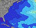 | 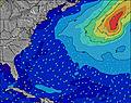 | 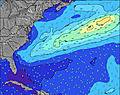 | 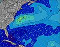 | 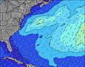 | 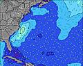 | 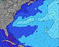 | |||||||||||||
Wave Height (m) Direction Period (s) | W 7 | W 7 | W 7 | W 7 | W 7 | W 7 | W 7 | W 7 | W 7 | WSW 6 | SE 8 | SE 8 | SE 8 | SE 8 | SE 8 | SE 8 | SE 8 | WSW 6 | WSW 6 | WSW 7 | WSW 7 |
Wave Graph | |||||||||||||||||||||
200 | 159 | 178 | 216 | 168 | 92 | 44 | 44 | 33 | 13 | 11 | 11 | 11 | 0 | 0 | 11 | 10 | 197 | 160 | 268 | 311 | |
Wind (km/h) | |||||||||||||||||||||
Wind State on-shore cross-onshore cross-shore cross-offshore off-shore glassy | cross-off | cross-off | cross-off | cross-off | cross-off | cross-off | cross-off | cross-off | cross-off | cross-off | cross | cross-off | glassy | cross-on | cross | cross | cross-off | cross-off | cross-off | cross-off | cross-off |
High Tide | 7:06AM0.67m | 7:39PM0.94m | 8:06AM0.71m | 8:36PM0.95m | 9:03AM0.75m | 9:30PM0.95m | 9:57AM0.78m | 10:21PM0.93m | 10:49AM0.81m | 11:11PM0.88m | 11:40AM0.82m | 11:59PM0.83m | 12:31PM0.82m | ||||||||
Low Tide | 1:20AM0.01m | 1:06PM-0.04m | 2:17AM-0.03m | 2:07PM-0.07m | 3:10AM-0.07m | 3:06PM-0.09m | 4:00AM-0.09m | 4:02PM-0.09m | 4:48AM-0.09m | 4:57PM-0.07m | 5:34AM-0.08m | 5:51PM-0.04m | 6:19AM-0.05m | ||||||||
— | 6:20 | — | — | 6:20 | — | — | 6:20 | — | — | 6:22 | — | — | 6:22 | — | — | 6:22 | — | — | 6:24 | — | |
8:28 | — | 8:27 | — | — | 8:27 | — | — | 8:27 | — | — | 8:25 | — | — | 8:25 | — | — | 8:24 | — | — | 8:24 | |
mm | 1 | — | — | 3 | 4 | 1 | 9 | 3 | 1 | — | — | — | — | — | — | 1 | — | — | 2 | — | — |
Temp °C | 27 | 26 | 26 | 26 | 26 | 27 | 26 | 26 | 26 | 26 | 25 | 25 | 25 | 26 | 27 | 27 | 26 | 27 | 27 | 26 | 27 |
Feels °C | 28 | 27 | 26 | 26 | 26 | 29 | 27 | 26 | 26 | 29 | 26 | 28 | 28 | 28 | 28 | 28 | 27 | 27 | 28 | 27 | 28 |
Swell 1 Height (m) Direction Period (s) | SE 9 | SE 9 | SE 9 | SE 9 | W 7 | W 7 | NE 7 | NE 7 | NE 6 | WSW 6 | ENE 6 | ENE 7 | ENE 6 | E 6 | ENE 6 | ENE 6 | SE 8 | SE 8 | SE 8 | SE 8 | SE 8 |
29 | 29 | 29 | 29 | 168 | 92 | 67 | 63 | 58 | 13 | 60 | 58 | 33 | 20 | 12 | 7 | 10 | 10 | 10 | 9 | 10 | |
Swell 2 Height (m) Direction Period (s) | N 6 | NE 7 | NE 6 | N 6 | SE 9 | NNE 7 | W 7 | W 7 | W 7 | SE 8 | SE 8 | SE 8 | SE 8 | SE 8 | SE 8 | SE 8 | ENE 6 | E 6 | NE 9 | ENE 9 | NE 8 |
1 | 2 | 2 | 1 | 29 | 48 | 44 | 44 | 33 | 18 | 11 | 11 | 11 | 17 | 17 | 11 | 8 | 3 | 3 | 8 | 3 | |
Swell 3 Height (m) Direction Period (s) | E 9 | E 9 | E 9 | E 8 | N 7 | SE 9 | SE 9 | SE 8 | SE 8 | N 5 | WSW 6 | W 6 | N 5 | NE 6 | NE 5 | SE 8 | SE 14 | NE 10 | SE 13 | SE 13 | SE 12 |
2 | 2 | 1 | 1 | 4 | 28 | 27 | 25 | 17 | 2 | 7 | 2 | 2 | 1 | 1 | 3 | 7 | 4 | 7 | 7 | 6 | |
Wind waves Height (m) Direction Period (s) | W 7 | W 7 | W 7 | W 7 | — | — | — | — | — | NE 6 | — | — | WSW 5 | WSW 3 | WSW 4 | WSW 4 | WSW 5 | WSW 6 | WSW 6 | WSW 7 | WSW 7 |
200 | 159 | 178 | 216 | — | — | — | — | — | 94 | — | — | 6 | 3 | 8 | 26 | 95 | 197 | 160 | 268 | 311 | |
Nearest Offshore or Glassy | |||||||||||||||||||||
Distance (km) | 1059 | 1064 | 1369 | 1148 | 1145 | 1135 | 1135 | 1053 | 1053 | 1 | 1057 | 1 | 1162 | 1217 | 1314 | 1053 | 1170 | 1582 | 1217 | 1289 | 1166 |
Best forecast wave conditions in Bermuda | |||||||||||||||||||||
Best forecast wave conditions in Bermuda | |||||||||||||||||||||
Header Global | |||||||||||||||||||||
- Map Icons:
 Break
Break Live Wave Height (m)
 Live Wind Speed (km/h)
 Surf Rating (10 Max)
 Ocean Swells (m)
- Wind Speed (km/h)


FREE! Surf-Forecast.com widget for your website
The surf report / weather widget below is available to embed on third party websites free of charge and provides a summary of our Castle Island surf forecast. Simply grab the html code snippet that we provide and paste it into your own site. You can choose your preferred language and metric/imperial units for the surf forecast feed to suit users of your site. Click here to get the code.
Information about the Castle Island Surf forecast
The above surf forecast table for Castle Island provides essential information for determining whether the surfing conditions will be good over the next 16 days. A general guide to surfing at Castle Island can be found by selecting the local surf guide option on the grey menu. Our Castle Island surf forecast is unique since it includes wave energy (power) that defines the real feel of the surf rather than just the height or the period. If you surf the same spot (Castle Island) regularly then make a mental note of the wave energy from the surf forecast table each time you go. Very soon you may start to choose your surf days based on the wave energy alone combined with our forecast of favourable offshore wind conditions. Our star ratings will help here and of course you will also find the usual wave height and period predictions on our surf forecasts as well as a full break down of the swell components under our advanced users option (to reveal that, click the little Einstein character under the tide times).
Further information to help with frequently asked questions about our surf forecast for Castle Island may be found under the help tab on the top menu and also by moving your mouse over the question marks on the surf forecast table itself. Please always bear in mind that the forecast is for near-shore open water and local factors at each surf break influence the actual breaking wave height, such as the beach / reef profile, water depths offshore and shelter.
Castle Cove is 98 km (61 miles) from the city of Warrnambool. If you plan a holiday in Far West of Victoria, look for hotels and other accommodation in Warrnambool. Warrnambool has rooms for a wide range of budgets as well as car hire and transport links.
 Nearest